

NOAA Teacher at Sea
Elli Simonen (she/her)
Aboard NOAA Ship Fairweather
July 10, 2023 – July 28, 2023
Mission: Hydrographic Survey of the Pribilof Islands
Geographic Area of Cruise: Pribilof Islands, Alaska
Date: July 19, 2023
Weather DataLocation: 57°11.82’N, 170°27.52’W
Outside temperature: 13°C
Water temperature: 11°C
True Winds: Direction 242.4°, 13.7 kn
Skies: Overcast and Foggy
Visibility: 2 nm
Sea Wave: 2 ft
Swell Wave: Direction 240°, 4 feet height
Science and Technology Log
We have arrived at the Pribilof Islands after being en route from Kodiak for 3 days. We are currently surveying.
Geology of the Aleutian Islands
The Aleutian islands stretch from North America into the Pacific and contain 40 active volcanoes. This string of islands is where the Pacific Plate sinks under the North American Plate causing some of the largest earthquakes of the last 100 years. NOAA Ship Fairweather often receives alerts about Volcanic Eruptions including information about ash in the water when sailing around the Aleutian Islands.
On July 15th at 10:48 pm, at a depth of 13 miles, a 7.2 magnitude earthquake struck just south of the Aleutian Peninsula, triggering a tsunami watch and then warning. NOAA Ship Fairweather was in the direct vicinity, but did not feel a noticeable shake. Luckily the tsunami watch and warning were canceled shortly after, and the earthquake did not cause significant wave heights. Investigation of observed water levels at the Sand Point, AK tide station showed some variability when compared to the tide predictions.

Observed water levels the night of the earthquake and tsunami warning.
Engineering On Board
The engineering team on NOAA Ship Fairweather consists of 8 engineers. They are in charge of maintaining the engine, all power and water on board. They typically work in 4-8 hour shifts, 24-hours per day, to ensure everything is running smoothly. The ship’s two main engines power shafts that are connected to controllable pitch propellers. To move a boat forward, both the pitch of the propellers and Revolutions Per Minute (RPM) are adjusted. Pitch is the angle of the propeller blades and RPM is how many times the propellers rotate per minute.
The engine room also supplies clean potable water for the entire ship. Through the process of reverse osmosis, sea water is compressed in cylinders and salt is filtered out. The water then goes through multi-stage and UV filters to ensure safe sanitation.
Power is supplied by three generators and one emergency generator. These generators power all electric, navigational and satellite receiver systems.

One of the Engines

Reverse Osmosis Unit, used to make potable water from seawater

TAS Elli Simonen in the Engine Room
Surveying with NOAA Ship Fairweather
We have been surveying at the Pribilof Islands for the last 1-2 days. We are surveying using the ship and the team is on a 24 hour rotation. The survey area is divided up into polygons, or smaller areas, of which we completely cover one at a time. The ship drives back and forth in overlapping lines over the designated polygon. In addition to the MBES data, we gather both backscatter and water column data as well.
Backscatter is a visual representation of the surface of the seafloor. Backscatter provides information about the intensity of the returned echos, from which the “hardness” of the bottom as well as other characteristics can be used to differentiate between different types of seafloor composition. Darker colors represent harder surfaces such as rocks and hard coral and lighter colors represent softer surfaces such as sand and mud. This information is important for ships to know for anchoring purposes, as well as benthic habitat characteristics.
The water column data shows us what is under the ship throughout the water column– from the surface of the water to the seafloor. It detects bubbles, objects protruding from the seafloor, fish, or even a whale or a seal.

Water column Data
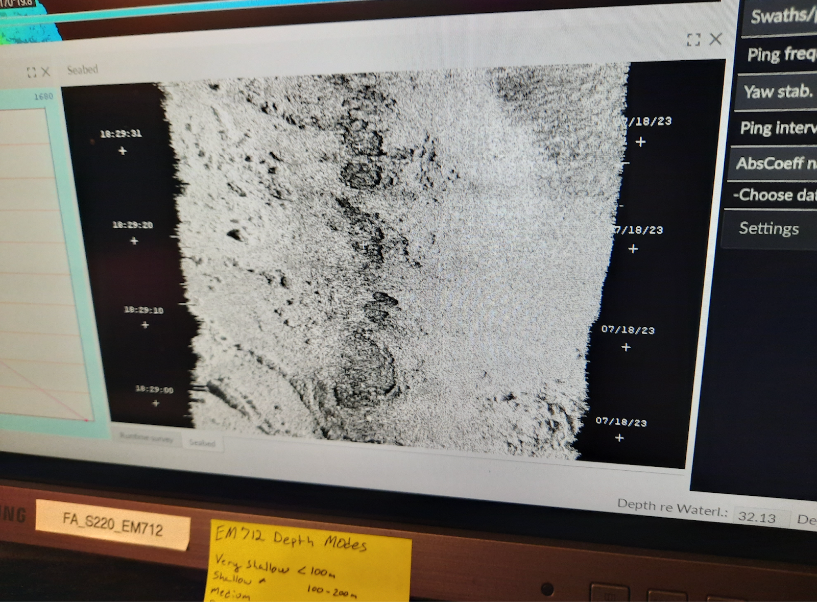
Backscatter showing a representation of the seafloor

TAS Elli Simonen with Survey Technician Finnegan Sougioultzoglou
Personal Log
Safety and Routine Checks
Before coming on board, I did not realize all the preemptive safety measures that need to be taken to ensure the health and safety of everyone on board. The staff and crew need to be self-sustaining on all accounts; another person, equipment or supplies cannot be added mid-sail. There are cooks onboard as well as medical staff. There are 3 drills and situations that the entire crew participates in, including myself – Fire, Mariner Overboard and Abandon Ship. You need to know the pattern of alarms for each, as well as where to go and what to do. For example, for Mariner Overboard I go to the fantail of the ship, with others, and point at the person in the water until a small boat can go out and rescue them. Each one of these drills is practiced periodically. Additionally there are two sets of rounds every hour, 24 hours a day – a deck round and engine rounds. Deck rounds check all public spaces for anything abnormal. Engine rounds check the engine room to see if everything is working properly. Every week, refrigerators are checked for correct temperatures and water is checked for potential bacteria.
New Terms/Phrases
I’ve learned several acronyms and initials since I have been on board NOAA Ship Fairweather. Sometimes I feel two consecutive sentences cannot be said without some type of abbreviation. These are some that have become part of my vocabulary:
- HIC: Hydrographer in Charge
- POD: Plan of the Day
- SOP: Standard Operating Procedure
- NM: Nautical Miles
- CO: Commanding Officer