Sue Zupko: 13 Who Ya Gonna Call? Mud Busters!

NOAA Teacher at Sea: Sue Zupko
NOAA Ship: Pisces
Mission: Extreme Corals 2011; Study deep water coral and its habitat off the east coast of FL
Geographical Area of Cruise: SE United States from off Mayport, FL to Biscayne Bay, FL
Date: June 9, 2011
Time: 1900

Weather Data from the Bridge
Position: 25.4°N  79.5°W
Present weather: overcast
Visibility: 10 n.m.
Wind Direction: 075°true
Wind Speed:  20 kts
Surface Wave Height:  4 ft
Swell Wave Direction: 100° true
Swell Wave Height:  4 ft
Surface Water Temperature:28.5 °C
Barometric Pressure: 1011.8 mb
Water Depth:  308 m
Salinity: 36.5 PSU
Wet/Dry Bulb: 28°/24.8°

This blog runs in chronological order.  If you haven’t been following, scroll down to “1 Introduction to my Voyage on the Pisces” and work your way back.

Take this quiz before reading this post.


James and Jeff wait for the winch to lift the pyramind-shaped grey grab
Waiting to lift the grab

When I started my journey as a Teacher at Sea, I wondered what scientific research the ship I would be placed on would be doing.  Would it be marine mammals in Alaska or Hawaii, hydrography (bottom mapping), a fishery study, buoy placement, or something I’d never heard of.  When I was told I was placed on the Pisces and we’d be using an ROV (remotely operated vehicle), I only knew we’d be using the vehicle to go to the bottom and look at corals since it is too deep to scuba dive.  I had no real concept of what else would be going on.  I did know my students liked the idea of the ROV since I am the Robotics Club advisor at Weatherly Heights Elementary.

Pyramid shaped grey grabber hanging over the ocean
Benthic Van Veer Grab

We have three missions on the Pisces.  One is to look at the bottom through the eyes of the camera lens to see what is actually happening with the coral and its habitat.  Another purpose was to update existing maps.  The third mission was the most difficult for me to get a grasp of just because it sounds so strange.  Benthic grabbing.  Benthos means bottom in Greek.  Like the soil on land, sediment lying on the bottom of the sea is full of creatures and information needed to fully understand the health of the corals and their habitat.  You don’t see the most of the animals living in soil usually either.  In soil on land and in the sea sediment, the animals living inside are called infauna, and provide food and nutrients to the epifauna (those living above the surface).  What effect has man had on this foundation of the coral reef?  What diversity of life is there and how plentiful are they?  What size are the lithogenic (of rock origin) particles?  It all means something and needs to be studied.

Sand on bottom of ocean
Sandy bottom for grab

According to Dr. Jeff Hyland, NOAA NCCOS (National Centers for Coastal Ocean Sciences), “People may wonder why scientists want to study the seemingly ‘barren’ sand (or muddy sand) layer that covers vast stretches of the ocean floor.  One good reason is because this important habitat is not barren at all!  The unconsolidated (loose) bottom that occupies the majority of the sea floor can be teaming with life.  The types of animals found can include polycheate worms, mollusks, crustaceans, and fish.  Some are large enough to see with the naked eye, but many are so small that you would need to use a microscope to see them. “

Three men in safety gear standing behind the pyramid shaped grey grab
James, Steve, and Jeff harvest their grab

The crew of scientists using the Van Veen grab equipment include: Dr. Jeff Hyland, James Daugomah, and Steve Roth (Grab Guys) of NOAA’s NCCOS Laboratory in Charleston, SC.  Ocean floor mapping is done prior to an ROV dive to help pinpoint the choicest spots for investigation.  After the ROV records the video from its dive, the “Grab Guys” go to work.  The science team confers and selects the best spots for study.  The beginning spot is relayed to the bridge, which then “makes it so” by taking the ship to those coordinates.

So, now what?  Every group on deck must wear hard hats and PFDs (life jackets—Personal Floatation Devices) since the winch will be used and they will be working near the side rail of the ship.   The fishermen (deck hands), scientists (both observers and the Grab Guys), and anyone who happens to be nearby must wear this equipment.  Safety first.

The fishermen and Grab Guys prepare for the sampling by dragging the 300 pound Van Veen grab close to the side.  It sits on a specially constructed table made of 2×4 wood and is painted grey.

Sink with water and plug plus two buckets on the left
Benthic cleaning equipment

Nearby, Steve sets up a smaller table with a sink in it, plus several buckets, a large spoon, and two rectangular plastic tubs nearby.  I really wondered what that was all about.

The winch hook is attached to the Van Veer grab and everyone stands ready.  When the bridge radios to the fishermen that the ship is over the drop site, they spring into action.  The winch operator waits for the signal from the lead fisherman that all is ready and is told by hand signals to raise it up.  As the winch lifts up the grab, those working the equipment help steady it over the deck and release it when it’s over the side.  The grab is lowered to the bottom as the winch operator monitors the amount of cable deployed.  The idea is that when the grab hits the bottom the release bar will pop and close the “grab jaws”.  If the grab isn’t going fast enough or lands on an angle it won’t close.  Plus, it might not go deep enough into the sediment to get a good sample.

Men standing in protective gear looking upward at the winch pulley
Watching the pulley for movement

It takes longer than you would think for that grab to hit bottom.  Remember, patience is a virtue.  The equipment drops 80 meters per minute.  Yesterday we were dropping to 320 meters.  All eyes are targeted on the winch’s pulley.  When the grab hits the bottom, it causes the pulley on the winch cable to swing, meaning that the grab has made contact.  Everyone crosses their fingers that the grab not only closed, but also got a large enough sample for an accurate test.  The winch driver begins to retrieve the gear.  It’s just like doing a science fair project.  You must repeat your experiment and have the right amount of sample so your repeated experiments  are as similar as possible when you repeat your procedure.  They must make three grabs which bring up the correct amount of sediment.  Often trial and error comes into play.  The current not only made things difficult for the ROV operations, it made the grab go down at an angle so it wouldn’t close (grab or fire) a few times.  They had to keep dropping until it worked correctly.  At one point the bottom was 370 meters and we had let out 425 meters of cable.  That meant that the wind and the current were really strong and pulling the grab out at an angle.

Pulley wheel hanging from an orange support
The winch pulley moved
Sieve bucket being swirled around in sink
Cleaning the mud off

Once the grab gets a sample, they scoop out sediment with a spoon and put it in a blue bin.  This is carried over to a sieve bucket and is half submerged and swished around in the sink to get the mud off.  This is repeated until all the sediment particles are clean.

Jeff in white helmet and orange PFD write information on a clipboard
Jeff records important information

The samples are scooped out of the sieve bucket and placed in containers which will be processed back at the laboratory.  In general, they are looking for sediment size (grain size), infauna (living organisms from the sediment), and chemicals from man.  The containers have been labeled with what tests need to be run.  Jeff is recording the numbers on the containers and whether that sediment should be tested for metals, toxicology, total carbon, organics, and sediment size.

Steve in PFD holding container with sediment and pink color
Steve holding organics sample

A special insert is placed in the grab to measure an exact amount of sediment to determine the amount of  the infauna.  This sample is cleaned and put in a large container with formalin mixed with rose bengal.  The rose bengal had been premixed by Dr. Hyland the first day so that when added to the sediment it will turn the living organisms a pink color, making them easier to find.

After the sediment samples are put in the smaller bottles, the top is screwed on, sealed with electrical tape to make sure it doesn’t open, and stored in the refrigerator or freezer. All these benthic samples will be sent to Barry Vittor, a company specializing in sediment analysis.

I have a new appreciation for the sediment in the ocean.  I’ve learned that sediment on the north side of a coral mound in the Gulf Stream usually has less nutrients since the current flows from south to north.  The coral and other plankton-consuming animals eat a lot of the food flowing in the current over the mound so the water on the north side contains less food and can support less infauna.  I hope my students enjoy learning about the benthos as much as I have.  Perhaps with the data we collected, scientists will be able to help determine what we need to do to preserve the corals of the reefs.

My Travails Thus Far…

I left for Alaska on the morning of June 10th- my flight out of Ft. Lauderdale was at 11:50.  Being the smart packer I am, I had a carry on bag with an extra change of clothes, some toiletries, and my heavy jacket.  This was going to be a long trip to get to Alaska, with lots of opportunities for my checked luggage to get lost, so I thought I’d be proactive.

No problems getting to Houston, and then on another plane from Houston to Anchorage.  Once I arrived in Anchorage Friday night around 7:45 their time (which is 4 hours behind us), my short flight to Kodiak was delayed by an hour.  Then two hours, three, then canceled altogether.  Apparently, the weather is very overcast in Kodiak and no planes are flying in or out.  So now, I’m in Anchorage (with all my bags, yay!) and have to find a hotel room, which was no biggie.  I go outside to wait for the hotel shuttle, and it’s about 10:45 p.m. and it’s bright sunlight!  Kind of weird, think about it- you’re getting ready to go out on a Friday night, and leave the house at 11:00, and it’s still light out.

My flight to Kodiak is re booked for Saturday at 9:45 a.m., so I get to the airport at 8:45, and my flight is already delayed due to weather.  One hour turns to two, two to three…I’m making phone calls to make sure the ship doesn’t leave without me(!) and I find out that most of the scientific party is stuck in Anchorage as well, so that makes me feel better.  My flight is now rescheduled to 7:20 p.m., so I just hang out at the airport all day.  What fun.

7:20 rolls around, and flight is delayed…until about 9:00 when it finally clears up enough in Kodiak for the pilot to land the plane.  So yipee, I’m finally getting on the plane to Kodiak and will be getting on the ship!!  I arrive in Kodiak and no bags show up.

Leaving Anchorage (at 9:30 p.m.) on my way to Kodiak finally!

Remember when I was bragging earlier about how smart I was, bringing my carryon with extra clothes in it?  Well, I checked it for this leg of the trip b/c I was lazy and didn’t feel like carrying it anymore 🙁  So now I’m in Kodiak with just a backpack of electronics and money.  Great.  One last flight from Anchorage arrives about 20 minutes after mine, and I barely want to look at the bags on the carousel.  Of course neither of mine are there.  They’re still in Anchorage, and will arrive on the first flight Sunday.  Keep in mind that as I’m writing this, it’s 3:20 p.m. Sunday, and no flights have yet to arrive because of the inclement weather.  I hop in a cab and speed to Wal-Mart (b/c it closes at midnight, and it’s 11:30 by the time I get in the cab) to grab some sweats to sleep in (I’ve been wearing the same jeans and t-shirt since Friday morning) and toiletries.  My bags DID get on a plane to Kodiak around 7:00 this morning, but the plane had to return to Anchorage b/c of the bad weather here.  Luckily (for me, not them), some of the scientific party is still stuck in Anchorage, and they’ve gotten my bags and will bring them whenever they get here.  So at least I know (hope) the bags are in reliable hands.  I’ve spent today just hanging out on the ship, because it’s been raining all day, and I have no raingear to protect me, so I can’t even go out exploring some of the hiking trails around here without fear of soaking the only clothes I have.

The harbor where the Oscar Dyson is docked. Just a bit overcast.

This has been quite an eventful trip thus far, and we haven’t even left port yet. We’re scheduled to leave at 0900 Monday, but the rest of the science crew and some deckhands aren’t here yet, so we’ll just have to wait and see.

Jason Moeller: June 11, 2011

NOAA TEACHER AT SEA
JASON MOELLER
ONBOARD NOAA SHIP OSCAR DYSON
JUNE 11 – JUNE 30, 2011

NOAA Teacher at Sea: Jason Moeller
Ship: Oscar Dyson
Mission: Walleye Pollock Survey
Geographic Location: Gulf of Alaska
Date: June 11, 2011

Personal Log

Welcome back, explorers!

Kodiak
Kodiak, Alaska

Today was my official first day in Kodiak Alaska! Kodiak is a small city on Kodiak Island, which lies off the southern coast of Alaska. The city had a population of 6,653 people in 2009, and is likely growing due to its unique population of animals, including salmon, Kodiak bears, and bald eagles. The city’s main livelihood comes from the ocean, where halibut, pollock, several species of salmon, scallops, and crabs are pulled from the waters surrounding the island. A second source of income comes from tourism.

I woke up today to find the city covered in mist with rain steadily falling. This was bad news for several of our scientists and Tammy, the other teacher at sea on our trip, as they were unable to fly in from Anchorage due to the weather.

Stateroom
Jason's Stateroom on the Oscar Dyson

The weather, however, did not stop me from having an active day in the city. The first thing that I did was move onto the ship into my stateroom, where I will be sleeping during the research expedition. I was surprised at the size, as the room was larger than several college dorm rooms that I had seen.

Once I was moved in, I began to explore the ship. While I have not been given an official guided tour as of yet (that will happen when Tammy arrives), I was able to move around and find some of the rooms that I will be in frequently during the trip.

Acoustic Room
This is the sound/acoustic room, where we will look for the fish using sonar!
Command Deck
This is the command deck of the Oscar Dyson. If I ask nicely, will they let me drive?
Mess hall
The all important mess hall!
Kodiak Bridge
Fred Zharoff Memorial Bridge

In talking with several individuals onboard, I found out that some of the best hiking in the area was within walking distance of the Oscar Dyson. Even better, hikers in this area occasionally saw bears. As I still wanted to see a bear in the wild, I immediately left for the bridge that would take me to another island right off the coast of Kodiak Island. I passed through town on the way.

After walking through town, I reached this bridge and crossed it.

The Island
This is the island that I was headed to.

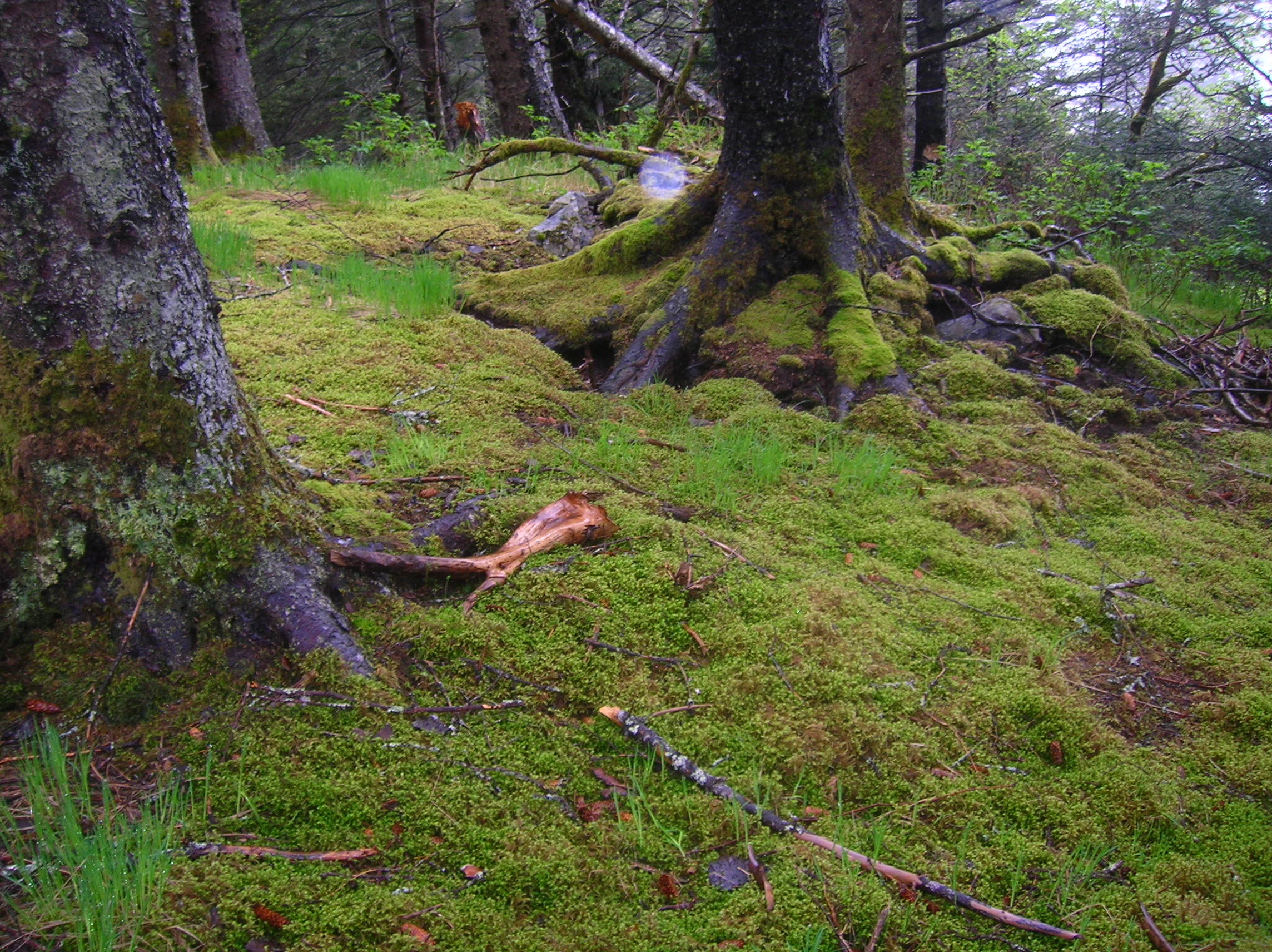
After crossing the bridge, I came across the following park which had some stunning nature trails. I am going to let my photographs do the talking for this next part of the blog, as words do not do justice for the beauty of this place.

Tree
There were many of these thick bodied pines in the park.
Moss
This image, as well as the next, shows the abundant moss in the woods. It carpeted the forest floor completely!

moss image 2

ocean view
A nice view of the ocean from the trail.
ocean view 2
Another beautiful view of the ocean from the trail.
moss on bushes
Many of the low-lying bushes also had moss and lichens on them.
Elderberries
One of the most common trees was the Pacific Red Elderberry. Elderberries are often used for making wines, and occasionally as the punchline in a joke.
Trees
A few Elderberry trees!

Surprisingly, I did not see a great deal of wildlife, only seeing songbirds. I still have time to see a bear, but I did not spot one today and did not see any bear tracks. Deer tracks were in abundance but I did not see any deer on the pathways.

All in all, I was out hiking on the trails for over three hours, and was soaking wet when I got back.

After the hike and a change of clothes (it rained the entire time), I went out to dinner with a few of the ship’s engineers to a sushi/seafood restaurant. The salmon just melted in my mouth, I have never had salmon that fresh. I also had the opportunity to taste Alaskan king crab, and wish that I hadn’t. I am now addicted, and it is expensive at $47.00 a pound being the market price!

Science and Technology Log

The science and technology section of this blog will begin after the survey of the Walleye Pollock has been started.

Species Seen

Arctic Tern

Pacific Red Elderberry

Reader Question(s) of the Day!

The reader question(s) of the day will start after the survey of the walleye pollock begins. I will answer at least one question during each log, and hopefully will be answering more than one. Please submit your questions to me at jmoeller@knoxville-zoo.org.

Kathleen Brown: Sea Science, June 11, 2011

NOAA Teacher at Sea
Kathleen Brown
Aboard R/V Hugh R. Sharp
June 7 – 18, 2011

Mission: Sea Scallop Survey
Geographical area of cruise: North Atlantic
Date: June 11, 2011

June 11, 2011

Weather Data from the Bridge
Time: 12:50 PM
Winds 12.9 KTs
Air Temperature: 11.94 C
Latitude 41 05.84N
Longitude 067 25.88 W

Science and Technology Log

Lowering the CTD
Lowering the CTD

Every third station along the journey, the crew takes a CTD reading. CTD stands for conductivity, temperature, and depth. Using a submersible set of probes, the characteristics of the ocean water are measured at set intervals, from the surface to the sea bottom, and then again from the sea bottom to the surface. Wynn, the marine technician, takes the time to explain to me that on this cruise the equipment is set to measure temperature, salinity, oxygen and phosphorescence. The probe is extremely heavy and must be lowered with a winch. The capability of the equipment is quite sophisticated and can take a water sample at any depth. A canister can be programmed to shut quickly, capturing approximately ten liters of water. The timing of the data collection process depends upon the depth of the water, but today it takes about five minutes. The data is collected for the NOAA team back on land.

Our journey will circle the outer edges of George’s Bank. We are on the eastern leg of the trip, somewhere between 80 and 100 miles from land. As far as the eye can see, it is ocean. Once in a while, we can see a fishing vessel off in the distance and we have seen dolphins and sunfish swimming near the ship. This afternoon I heard Mary, the First Mate, announce over the radio that she spotted a whale. I ran up to the bridge to see if I could get a look, but I was too late!

I have been eager to learn the stories of the scientists and crew, and to find out what has drawn them to the work at sea. The backgrounds of the people on the ship are varied, and they are both men and women of all ages. One person reports, “ I knew that I wanted to be a marine biologist since fifth grade.” Another says, “I grew up around boats.” Yet another speaks about wanting a hands-on career that could last a lifetime. There are several students on this leg of the cruise. I have learned there are many paths to the career at sea: experience in the military, technical school, college and university, and hands on experience over the years It seems that if you are attracted to the sea, you have a place on a scientific research vessel.

Personal Log
Toward the end of the day, the boat starts to roll a bit more than it has. We have been informed that the wave heights tomorrow may increase to 5 to 8 feet. Taking a shower while the boat rocks from side to side is challenging. I grip my flip flops to the floor of the shower and hang on!

Question of the Day
What do you think the level of salt in the water can tell scientists?

Jason Moeller: June 10, 2011

NOAA TEACHER AT SEA
JASON MOELLER
ONBOARD NOAA SHIP OSCAR DYSON
JUNE 11 – JUNE 30, 2011

NOAA Teacher at Sea: Jason Moeller
Ship: Oscar Dyson
Mission: Walleye Pollock Survey
Geographic Location: Gulf of Alaska
Date: June 10, 2011

Personal Log

Welcome aboard, explorers!

For those of you who do not know me, my name is Jason Moeller, and I am the on-site coordinator of education at Knoxville Zoological Gardens. I teach the school groups, scouts, homeschool students, and student researchers who come to the Zoo to learn about the natural world.

Oscar Dyson

The Oscar Dyson sits in Kodiak Harbor

The National Oceanic and Atmospheric Administration, or NOAA, has invited me on board the Oscar Dyson, a research vessel that will be spending the next three weeks researching a fish known as the walleye pollock in Alaska’s Bering Sea. According to NOAA’s website, the pollock made up 56.3% of Alaska’s groundfish catch, easily making it the most caught fish in Alaska’s waters. Pollock is commonly found in imitation crabmeat as well as a variety of fast food fish sandwiches.

The crew of the Oscar Dyson will be studying the population of pollock over the course of the next three weeks. I will be working with Tammy Orilio (another teacher at sea) in processing the catch. Orientation will be on June 11th, and we will set sail on June 12th.

Clouds from an airplane

Clouds above Canada

Today (June 10th), however, was mainly a travel day. After waking up at four in the morning, I caught a two-hour flight from Knoxville to Chicago, which was then followed by a six-hour flight to Anchorage. Finally, I had a forty-one minute flight from Anchorage to Kodiak. Cloud cover marred what would have been spectacular scenery, but there were some beautiful views from the aircraft otherwise.

After a quick look at the Oscar Dyson and dinner at the hotel, I went to explore the river running by our hotel. According to several fishermen, Sockeye Salmon are beginning their yearly run upriver. Grizzly Bears, though uncommon this time of year, are also occasionally spotted.

Possible Bear track

Unknown Large Track

Unfortunately, I did not see bears or salmon, but I did see this track. While faded, it did look suspiciously like the mold of a track back at the zoo.

While I did not see any bears or salmon, I did get lucky in other regards. I saw a beautiful red fox, which moved too quickly to catch on film, and rabbits were in abundance. The scenery was also beautiful.

Sideways trees

Wind on a hill shaped these trees

river in Kodiak

A river in Kodiak

Science and Technology Log

The Science and Technology segment of this blog will begin after the Walleye Pollock Survey aboard the Oscar Dyson begins.

Species Seen

Red Fox

Rabbit

Reader Question(s) of the Day!

The reader question(s) of the day will also begin after the start of the Walleye Pollock Survey aboard the Oscar Dyson. Readers are encouraged to send questions to jnmoelle@knoxville-zoo.org. I will attempt to answer one or more questions in future posts.