NOAA Teacher at Sea: Karen Rasmussen
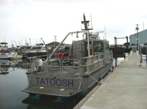
Ship: R/V Tattoosh
Geographical area of the cruise: Olympic Coast NMS
Date: June 27, 2011
Cruise to: Port Angeles Harbor
Crew: Nathan Witherly, Karen Rasmussen
Time: Start 10:30 – End 12:2
Mission
The first part of mission is to conduct Multibeam mapping and to collect ground-truthings at the LaPush/Teahwhit areas of the Olympic Coast National Marine Sanctuary. We will also service the OCNM buoy, Cape Alava 42 (CA42). The second week of this mission is to explore the Teahwhit Head moorings, ChaBa and sunken ships, and North and South moorings.
Weather Data
Calm seas/wind
Science and Technology Log

We began this morning at 8:00 a.m. Tatoosh had been dry docked at the Port of Port Angeles to have the multibeam fixed. This mission was to have started last week but had to be postponed because of a small leak in the multibeam. This morning the Tatoosh was lowered into the water to take the measurements in order to check the accuracy of the multibeam. Nathan drove the boat to Hollywood Beach (Port Angeles, WA) so we could help take readings. Rick and Nancy stayed onshore and used a surveyor’s tripod with an optical level. I held the surveyor’s rod and we completed a dynamic draft measurement of the Tatoosh. Rick took 3 readings from each position the Tatoosh was in over approximately two hours. Later Nancy and I entered their data into the Hypack software program. I read the data as she typed it in. We finished and found that our computer software programs are not interfacing with each other.

The HYPAK Program Inc. is Windows-based software created for the hydrographic
and dredging industries. It includes ways to complete surveys, collect data, process it, and generate final products. It can be used on small or large vessels and is also used to collect environmental data.
HYSWEEP is a module of HYPACK and is used with multibeam and side scan sonar. It gives on-the-spot information about the ocean’s bottom condition and data quality from your multibeam devise.
HYSWEEP measures:
- Depth – Nadir beam depth in survey units (ten units to one foot)
- Time (Event)
- Tide Corrections
- Draft Correction
- Heave (in survey units, positive upward)
- Roll – port side
- Pitch – bow up
- Heading
- Easting/Northing (Like XY coordination, X= Easting, Y=Northing)
Personal Log
My learning curve is tremendous today and I am extremely tired. Last night I stayed at the Red Lion in Port Angeles. I was up until almost 4 a.m. Apparently, they are having teenager issues. Lots of horn blowing, yelling, and fighting all night long. I am hoping that tonight will be better.
I really enjoyed being part of the team today. Nancy, Rick, and Nathan have been wonderful with answering all of my questions. Some of the questions I’ve been asking must seem so obvious to them, but my knowledge of underwater geography is so limited. Every aspect of this day has been interesting. I am truly amazed at what these people are doing with the limited and older materials they are using.

