

NOAA Teacher at Sea Lisa Battig
Aboard Fairweather, Alaskan Hydrographic Survey vessel
September 5, 2017
Location: 56o20.5N 166o07.1W (We are currently ~ 170 miles due east of the Alaskan Peninsular National Wildlife Refuge!)
Weather from the bridge: 51o F, Wind 8-10 knots from 285o, high thin clouds, seas 2-3 ft (1 hour after I wrote this we were socked in with fog, which is fairly common for this part of Alaska during this time of year.)
Science and Technology Log:
Fairweather was commissioned in 1968 and has 2 engines. The engines are pretty ridiculously big. They are diesel combustion engines and run similarly to a diesel tractor engine.

She was built with Controllable Pitch Propellers. This technology is fascinating!! It allows for very fine control of the ship’s motion.
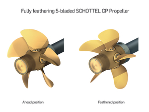
The CPP technology works by turning each of the propeller blades on its individual axis. In this way, the propellers never have to change the direction of spin, but instead the spin continues the same direction but the ship can come to a stop and then reverse direction. This differs from the fixed propeller system that is on the small launches. The Fairweather’s propeller blades are about 3 feet each in size for a total propeller diameter of 7 feet.
She also has a bow thruster which can be used in certain circumstances. The bow thruster enables the bow to move from side to side while the stern of the ship is static. It is essentially a propeller mounted into a tunnel/hole in the bow giving thrust perpendicular to the typical direction of travel. For a large ship like Fairweather, this is especially helpful when moving in and out of docking locations.
The next two technologies are of particular interest for my environmental science classes. Because the ship is often at sea for extended periods, it is necessary to make fresh water from the salt water. Typically Fairweather will take on ~16,000 gallons of water in port, but evaporators will be used to generate supplemental freshwater when it is needed.

The evaporators on Fairweather are flash (plate) evaporators and they can generate around 160 gallons of water per hour when operating optimally. The evaporators are running a distillation process by evaporating the water using heat from the boilers at a low pressure and then separating the freshwater from the brine (highly saline water). Because of the constant removal of salt from the water, the evaporators need to be cleaned often for best use.

The brine is then discharged and the freshwater is added to the supply tanks. When leaving the tanks, it is pumped to higher pressure and further treated through filters and with UV light to kill off any bacteria that may have made it through. That water is stored in a hydropneumatic tank at high pressure so that water can be delivered to all parts of the ship without the need for continuously running pumps.
People eat and drink and then they pee and poop. They also like to shower and brush their teeth and wash their hands. They also need water to drink and cook with and to make coffee and tea. Obviously there is also a lot of gray water (sinks and showers) and black water (toilets) that is produced on a ship of this size carrying ~40 people. So what is done with all of it? Well, blackwater goes through the MSD (marine sanitation device) before it is discharged outside of 3 nautical miles from land. MSDs are standard on all ships and work similarly to land based sewage treatment on a much smaller scale. Gray water can be acceptably discharged as is in most places, but must be stored within NDZs or No Discharge Zones.

Other necessary technologies on the ship are the refrigeration system, the boilers and the generators. But I won’t go into all of those processes. It’s just amazing to me that there are so many things that must be accounted for on a ship if it will be at sea for multiple days!
Crew of the Day! Engineering


The Engineering crew on this ship is a highly eclectic bunch! They are also a REALLY difficult group to get together for pictures. They have about a 40 year span in age and include folks from all over the world with a great diversity of backgrounds. There are several levels within the engineering crew. The entry level position is termed a wiper, next is an oiler, and then engineering utility, and junior engineer. These positions are unlicensed, analogous to enlisted positions in the military. The licensed positions are 3rd Engineer, 2nd Engineer, 1st Engineer and Chief Engineer. There are five licensed engineers on board right now and another six in the department who are oilers and junior engineers.
Anything that is mechanized, motorized, has an electric cable going to it, or needs to be oiled or lubed, those things all fall under the watchful eye of the Engineering crew. One of the young 3rd Engineers, Connor (nicknamed Titan because he really is giant) also describes them overseeing “Hotel Services” – plumbing, lighting, heating & cooling. The crew keeps a 24 hour watch whenever the ship is underway, and can take over aft steering if something were to fail with the bridge steering. They are also on watch whenever the small launches are being deployed or replaced to their cradles. If the bow thruster is being used, a crew member will also watch to see that it engages properly for use.
The well-being of the ship is in the hands of the Engineers and therefore the Chief Engineer reports directly to the Commanding Officer (where all other department heads report to the Executive Officer). The CO and the Chief Engineer really share the task of running the ship, but ultimate responsibility lies with the CO.
Personal Log:
The food! OH MY GOODNESS!!! The food on Fairweather has been terrific. There are two amazing cooks here currently. Tyrone, who is the Chief Cook, has been with Fairweather for 5 years. Prior to that, he cooked for the Navy. Kathy is the Chief Steward (which means she is in charge of the kitchen and develops the daily menus) and has been with NOAA ships cooking in some capacity for almost 20 years! You’ll learn more about her in my next blog… The Interview Issue!
So, here’s a sampling of what’s been on the menu since I’ve been here: Prime Rib, Lobster, Argentinian flap steak with Chimichurri, Halibut with some crazy good pesto type sauce… I am going to leave the ship about 10 pounds heavier than when I got here. So, this is not what you always get on NOAA ships, but this particular pairing of Kathy and Tyrone makes some serious magic!!


 A. search and rescue transponder B. an emergency flashlight C. a marker buoy D. a flare gun


 A. an ocean desalinization unit B. an oil filter C. a fuel tank D. a sewage treatment unit