NOAA Teacher at Sea
Jacob Tanenbaum Onboard NOAA Ship Miller Freeman June 1 – 30, 2006
Mission: Bering Sea Fisheries Research Geographic Region: Bering Sea Date: June 20, 2006
Personal Log
Click here if you would like to look at the results from the Pollock Study.
This will be my last blog entry for the trip. As the project draws to a close, I would like to evaluate how effective it was. There is a link to an electronic survey. I would like to ask students, teachers, parents, and other visitors to the site to take a few moments to let me know what you think of this idea. The survey is all electronic and only takes a minute or two to complete. Thank you in advance for your time. Click here to access the survey.
Wild horses
Today we arrived in the port of Dutch Harbor, Alaska early this morning. Dutch Harbor is a fishing village full of interesting sites to see and people to meet. It is also where the fishing vessels featured in the TV show “Deadliest Catch” are based, so a lot of you may have heard of it. The highlights of an incredible included a herd of wild horses. Their ancestors were released here by US soldiers stationed here after World War 2. We couldn’t figure out what they ate until… 🙂
Climbing in mountains full of wildflowers.Standing on the glacier
An incredible end to an incredible journey. Thanks all of you for sharing it with me.
Final Thoughts:
I would like to express my profound appreciation to everyone on board NOAA Ship MILLER FREEMAN. Every single person on board the ship welcomed me and helped me in every possible way with this project. The scientists and ships personnel answered every one of mine and your thousands of questions and opened the entire ship up to us all. Many of the people on board shared the blog with their families back home, and the notes I have gotten back from them touched me deeply.
To Commander Gallagher, Lieutenant Commander Boland, Dr. Paul Walline and the everyone on board, thank you for making this project possible and for all you have done to welcome me on board the ship these past weeks.
Thank you as well to the Jennifer Hammond, Elizabeth McMahon and everyone at the Teacher At Sea program for creating this wonderful opportunity and for all of your support before and during the project.
Thank you as well to all of you back home for taking part in this experiment. Teaching and learning with you from the Bering Sea has been one of the most rewarding experiences of my 19 years as an educator.
NOAA Teacher at Sea
Jacob Tanenbaum Onboard NOAA Ship Miller Freeman June 1 – 30, 2006
Mission: Bering Sea Fisheries Research Geographic Region: Bering Sea Date: June 19, 2006
Mountains in the clouds
Weather Data from the Bridge
Visibility: Less than 1 mile
Wind Speed: 14 miles per hour
Sea Wave Height: 2 feet
Water Temperature: 44.06 degrees
Air Temperature: 41.36 degrees
Pressure: 1018 Millibars
Personal Log
NOTE: We will arrive in the port of Dutch Harbor, Alaska on June 20. As the project draws to a close, I would like to evaluate how effective it was. There is a link to an electronic survey. I would like to ask students, teachers, parents, and other visitors to the site to take a few moments to let me know what you think of this idea. The survey is all electronic and only takes a minute or two to complete. Thank you in advance for your time. Click here to access the survey. I should be able to send one more blog tomorrow from Dutch Harbor. Check back and I will let you know what being on land again feels like. Dutch Harbor should be an interesting place.
Large sea stars from the bottom trawl
We passed the Pribilof Islands. Home to one of the largest worlds largest gatherings of marine mammals in the summer time. I got up to see the islands at midnight and again when we passed a second one at 4:00 AM. We were covered in fog both times, so we will have to come back another day. At midnight, the sun had not yet set. Our sun set last night at about 12:15 and it took a long time to grow dark after that. The sky began to grow light at about 5:00 and it came up a little after 6. A short night.
Science Log
Last night we had another bottom trawl. This one had some of the largest sea stars I have ever seen. One was close to a foot long. In addition, there is a coral here called sea raspberry. It is common along the Bering Sea Shelf. I thought coral was only in tropical seas, but here it is in the Bering Sea. Since it is our last day at sea, I spoke to our Chief Scientist Dr. Paul Walline from the Alaska Fisheries Science Center in Seattle Washington about what we have learned so far.
Finally, we were testing a platform today that can open nets at different depths. We lowered the platform to about 390 feet before a technical problem forced us to raise it back up to the surface. As an experiment of my own, I tied a bag of Styrofoam cups to the platform to see what the pressure at that depth would do to them. Want to see more? Click here for a video
Question of the Day:
What was your favorite part about participating in this project. Please write and let me know.
NOAA Teacher at Sea
Jacob Tanenbaum Onboard NOAA Ship Miller Freeman June 1 – 30, 2006
Mission: Bering Sea Fisheries Research Geographic Region: Bering Sea Date: June 18, 2006
Weather Data from the Bridge
Visibility: 10 miles
Wind Speed: 9 miles per hour
Sea Wave Height:2 feet
Water Temperature:41 degrees
Air Temperature:40.8 degrees
Pressure: 1013 Millibars
Personal Log
NOTE: We will arrive in the port of Dutch Harbor, Alaska on June 20. As the project draws to a close, I would like to evaluate how effective it was. There is a link to an electronic survey. I would like to ask students, teachers, parents, and other visitors to the site to take a few moments to let me know what you think of this idea. The survey is all electronic and only takes a minute or two to complete. Thank you in advance for your time. Click here to access the survey.
Sea cucumbers
By now, you have met many of the interesting people aboard NOAA ship MILLER FREEMAN. There are three groups of people aboard these ships. The officers on the ship are part of the NOAA Corps. This is a uniformed service of the United States consisting of about 300 officers who complete rigorous training and hold ranks, like ensign, or commander. They are in charge of ships operations and stand watch on the bridge. The scientists aboard are mostly from NOAA research labs, like the Alaska Fisheries Science Center in Seattle. Many of the other members of the crew are civilian wage mariners. These are professional sailors who handle many of the day to day operations of the ship. Some, such as Chief Engineer Bus, have made their home on this ship for close to 30 years. Other sailors are contract workers who come aboard for a few months, go home and take a break, then join the crew of another ship for a different sort of cruise. Sometimes they are on research vessels, sometimes they are on freighters, sometimes they are on tankers. Today, lets meet able-bodied seaman, or AB Michael O’Neal. Click each question to listen to the answer.
We had another in a series of amazing bottom trawls last night. When the nets trawl along the bottom out here, some of the most interesting creatures of all get swept into our nets. Creatures that live on the bottom are often stranger looking for a few reasons. They are adapted to blend into the bottom so that predators cannot see them. They often wind up looking like rocks or plants as a kind of defense. They are also adapted to an environment with higher pressure and less light than the surface. Some of their adaptations can also make them look very different from other fish. Since they don’t have to worry about predators below them, these fish may be flat and have both their eyes sticking up. These creatures often do not need to be fast swimmers, since their defense is to blend into the environment rather than swim away when predators approach. The basket of sea cucumbers was one of the strangest things I’ve seen so far. These sticky blobs are not plants. They are sea creatures that live on the bottom of the sea and sift through the sand or water to find food. There are several different kinds of sea cucumbers in this basket. Can you see the different types? Mud stars, on the other hand, are soft and sticky, not like the sea stars we have at home. It may be called a mud star, but I think looks like Patrick from Sponge Bob.
Another kind of sculpin with large fins that look like the wings of a butterfly, called a Butterfly sculpin.
Question of the Day
Now that you have seen some of the different jobs aboard NOAA Ship MILLER FREEMAN, if you were on a ship, which job would you prefer? Write me a comment on the blog and let me know!
Answer to Yesterday’s Question
Look at the movements of the ship described above. When the ship drives into the wind and waves, sailors call it a corkscrew motion. Can you think why?
A corkscrew motion occurs when the ship is struck by waves in such a way that it moves in several motions at once. In other words, it may pitch, roll, surge, and sway all at the same time. I’m getting a funny feeling in my stomach just thinking about it!
Answers to Your Questions
Sorry that I left off the link from Friday where you can see the position of the ship. Here it is. Fair warning, the site was down for most of today, so if it does not work, just try again later.
After we put in to port, I’ll have a day or two in Dutch Harbor to look around, before I can get a flight in to Anchorage. After that, I’ll be visiting some friends and family out west before I head back east. Thanks for writing.
NOAA Teacher at Sea
Jacob Tanenbaum Onboard NOAA Ship Miller Freeman June 1 – 30, 2006
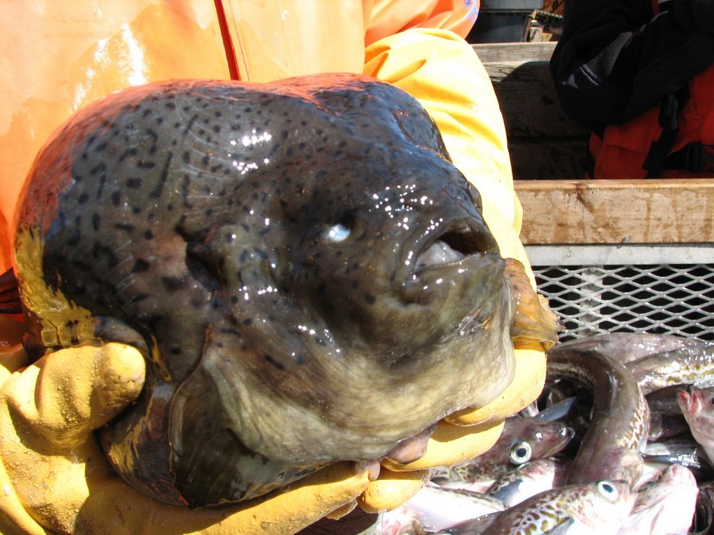
Mission: Bering Sea Fisheries Research Geographic Region: Bering Sea Date: June 17, 2006
Smooth Lumpsucker fish.
Weather Data from the Bridge
Visibility: 14 miles
Wind Speed: 25 miles per hour
Sea Wave Height 7: feet
Water Temperature: 44.06 degrees
Air Temperature: 44.96 degrees
Pressure: 1009 Millibars
Personal Log
NOTE: We will arrive in the port of Dutch Harbor, Alaska on June 20. As the project draws to a close, I would like to evaluate how effective it was. There is a link to an electronic survey. I would like to ask students, teachers, parents, and other visitors to the site to take a few moments to let me know what you think of this idea. The survey is all electronic and only takes a minute or two to complete. Thank you in advance for your time. Click here to access the survey.
Well, we had pea soup for lunch today, also called storm soup by sailors. Legend is that when you serve pea soup, the weather will turn stormy, and sure enough, a gale is blowing nearby and the waves are picking up. The soup was great, though. As the ship rocks and rolls to the rhythm of the waves, lets take a closer look at how it moves. Sailors have lots of different terms for ships movement:
Pitch – refers to the up and down movement of the front, and back, or bow and stern of the ship
Yaw — when the ship spins from side to side.
Heave — When the entire ship moves up and down.
Roll — When the ship rocks from side to side.
Surge – When the ship jumps forward or backward.
Sway – When the ship jumps sideways.
Happy Father’s Day to all. A special hello to my own father, Elias, and my two son’s Nicky and Simon. I miss you, guys.
Science Log
Our trawl nets picked up the smooth lumpsucker fish near the bottom last night. This fish tends to say near the bottom and can inflate itself with water as a defense against predators. A good defense, I would say. Would you want to eat it?
Our survey continues. We brought in two hauls of fish this morning. Tamara is having less time on the bridge looking for birds in the last day or so. Her time is limited because we are fishing more and a large group of birds following a fishing net is not considered a natural occurrence, so she does not count them in her study. If the waves are too high, she cannot see the small birds in the troughs of the waves, so she can’t count during heavy seas, and right now, the seas are fairly heavy.
Question of the Day:
Look at the movements of the ship described above. When the ship drives into the wind and waves, sailors call it a corkscrew motion. Can you think why?
Answer to Yesterday’s Question
It is about 8:00 AM on Saturday morning. If the ship uses 2100 gallons of fuel a day, how many gallons of fuel will we need to get to Dutch Harbor on Tuesday Morning at about 8:00 AM?
It will take 3 days to reach Dutch Harbor. Since the ship uses 2100 gallons of fuel a day, we have to multiply 2100 x 3 which equals 6300 gallons of fuel. Enough for my car to drive 157500 miles. Wow.
Answers to Your Questions
NOAA Teacher at Sea
Jacob Tanenbaum Onboard NOAA Ship Miller Freeman June 1 – 30, 2006
Waves washing over the bow of NOAA Ship MILLER FREEMAN
Mission: Bering Sea Fisheries Research Geographic Region: Bering Sea Date: June 16, 2006
Weather Data from the Bridge
Visibility: 14 miles
Wind Speed: 27 miles per hour
Sea Wave Height: 7 feet
Water Temperature: 41.7 degrees
Air Temperature: 42.4 degrees
Pressure: 1013.8 Millibars
Plotting longitude and latitude
Personal Log
NOTE: We will arrive in the port of Dutch Harbor, Alaska on June 20. As the project draws to a close, I would like to evaluate how effective it was. There is a link to an electronic survey. I would like to ask students, teachers, parents, and other visitors to the site to take a few moments to let me know what you think of this idea. The survey is all electronic and only takes a minute or two to complete. Thank you in advance for your time. Click here to access the survey. How do you find your way around when you can’t see any land? I spent some time with Ensign Lindsey Vandenberg, on NOAA Ship MILLER FREEMAN.
Plotting longitude and latitude
Every 30 minutes or so, the bridge officers take a “fix” on their position. How do they do it? When they are out at sea, they take the latitude and longitude from the GPS and plot their exact position on a chart. A GPS is a machine that uses satellites to display the exact longitude and Latitude on a screen. The charts also have the latitude and longitudes written on them, but there is a problem. The longitude and latitudes scales on the chart are on the side and bottom of the chart, not where the ship is located. Every so often, there is a line across the entire chart. The navigator must use a tool, like the same compass you might use in math class, to mark the distance to the exact point on a scale from a line on the chart. She can then use the same tool to mark the distance in the part of the chart where we actually are. This must be done for both the longitude and latitude of the ship.
Ploting the bearing on a map
When we are near land, we can use Terrestrial Navigation. This means we can use the distance to an object on the shore, such as a lighthouse, to find out wherewe are. With a large ship close to shore, it is very important that we know exactly where we are so that we don’t wind up in shallow water. Ensign Vandenberg uses a tool called an alidade to help her. She puts the alidade over a large compass outside of the ship. The instrument reflects the compass into the viewer so she can see both the object on shore and the exact compass heading. If she takes a few bearings to objects on shore, she can use tools to chart her exact position on the chart.
Science Log:
I’ve been asking many of the people on the ship what becomes of the data that we are collecting. This survey will be used to set quotas for one of the most important fisheries in the world. Here is how it works. If too many fish are caught in an area, there will not be enough fish left for the species to come back the next year. That is bad for the fish, and bad for the fisherman. To prevent this “overfishing,”. A quota, or limit to the number of fish that can be safely caught, is established. Methods are put in place to make sure that all fishing boats in the area respect the quotas. Do you want to learn more? Take a look at this short video on the subject.
Question of the Day:
It is about 8:00 AM on Saturday morning. If the ship uses 2100 gallons of fuel a day, how many gallons of fuel will we need to get to Dutch Harbor on Tuesday Morning at about 8:00 AM?
Answers to Yesterday’s Question:
If our ship wants to do a trawl 50 meters below the surface, how much wire would it need.
The ship must put out two feet of wire for every one foot of depth. So you have to multiply 50 x 2 which gives 100 meters of wire. Each net has, not one, but three wires holding it to the ship. So you would need 3 wires. All three are 100 meters in length. That gives us 300 meters of wire to do our trawl.
Answers to Your Questions:
Hello to all who wrote today.
Colin, no seawater on the equipment yet. They have a couple of computers in the lab where we process fish that can be drenched with water and will still work. Maybe I need one of those.
Mrs. Z. Click here to see the route we have taken so far. I do not think it will give you exact miles, but you can get a good idea of our total.


 Mission: Bering Sea Fisheries Research