NOAA Teacher at Sea Cathrine Prenot Aboard Bell M. Shimada July 17-July 30, 2016
Mission: 2016 California Current Ecosystem: Investigations of hake survey methods, life history, and associated ecosystem
Geographical area of cruise: Pacific Coast from Newport, OR to Seattle, WA
Date: Sunday, July 24, 2016
Weather Data from the Bridge
Lat: 47º32.20 N
Lon: 125º11.21 W
Speed: 10.4 knots
Windspeed: 19.01 deg/knots
Barometer: 1020.26 mBars
Air Temp: 16.3 degrees Celsius
Water Temp: 17.09 degrees Celsius
Science and Technology Log
Typical evening view from the flying bridge of the Bell M. Shimada
We have been cruising along watching fish on our transects and trawling 2-4 times a day. Most of the trawls are predominantly hake, but I have gotten to see a few different species of rockfish too—Widow rockfish, Yellowtail rockfish, and Pacific Ocean Perch (everyone calls them P.O.P.)—and took their lengths, weights, sexes, stomachs, ovaries, and otoliths…
…but you probably don’t know what all that means.
The science team sorts all of the catch down to Genus species, and randomly select smaller sub-samples of each type of organism. We weigh the total mass of each species. Sometimes we save whole physical samples—for example, a researcher back on shore wants samples of fish under 30cm, or all squid, or herring, so we bag and freeze whole fish or the squid.
For the “sub samples” (1-350 fish, ish) we do some pretty intense data collection. We determine the sex of the fish by cutting them open and looking for ovaries or testes. We identify and preserve all prey we find in the stomachs of Yellowtail Rockfish, and preserve the ovaries of this species’ females and others as well. We measure fish individual lengths and masses, take photos of lamprey scars, and then collect their otoliths.
Fish Otolith showing concentric growth rings from here.
Otoliths are hard bones in the skull of fish right behind the brain. Fish use them for balance in the water; scientists can use them to determine a fish’s age by counting the number of rings. Otoliths can also be used to identify the species of fish.
Here is how you remove them: it’s a bit gross.
Otolith instructions from here.Cod, Redfish, and Hake otoliths from here.
A bigger fish species does not necessarily mean a larger otolith. From here.
If you want to check out an amazing database of otoliths, or if you decide to collect a few and want to see what species or age of fish you caught, or if you are an anthropologist and want to see what fish people ate a long time ago? Check out the Alaska Fisheries Science Center—they will be a good starting spot. You can even run a play a little game to age fish bones!
Pacific Ocean Perch, or P.O.P.
Personal Log
I haven’t had a lot of spare time since we’ve been fishing, but I did manage to finagle my way into the galley (kitchen) to work with Chief Steward Larry and Second Cook Arlene. They graciously let me ask a lot of questions and help make donuts and fish tacos! No, not donut fish tacos. Gross.
How to make friends and influence people
Working in the galley got me thinking of “ship jargon,” and I spent this morning reading all sorts of etymology. I was interested to learn that the term crow’s nest came from the times of the Vikings when they used crows or raven to aid navigation for land. Or that in the days of the tall ships, a boat that lost a captain or officer at sea would fly blue flags and paint a blue band on the hull—hence why we say we are “feeling blue.” There are a lot more, and you can read some interesting ones here.
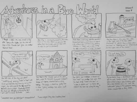
You can also click on Adventures in a Blue World below (cartoon citations 1 and 2).
And here is a nautical primer from Adventures in a Blue World Volume 1:
A Nautical Primer from 2011 aboard the Oscar Dyson
Did You Know?
Working in the wet lab can be, well, wet and gross. We process hundreds of fish for data, and then have hoses from the ceiling to spray off fish parts, and two huge hoses to blast off the conveyor belt and floors when we are done. But… …I kind of love it.
Interestingly enough, the very words “Sea Speak” have a meaning. When an Officer of the Deck radios other ships in the surrounding water, they typically use a predetermined way of speaking, to avoid confusion. For example, the number 324 would be said three-two-four.
NOAA Teacher at Sea
Dave Grant
Onboard NOAA Ship Ronald H. Brown November 6 – December 3, 2008
Mission: VOCALS, an international field experiment designed to better understand the physical and chemical processes of oceanic climate systems Geographical area of cruise: Southeast Pacific Date: November 11, 2008
Pilot boat alongside the Brown
Science and Technology Log
The ship was cheered, the harbor cleared, Merrily did we drop, Below the kirk, below the hill, Below the lighthouse top – Coleridge
Finally, it is time to cast off. For days the scuttlebutt has kept us guessing about what has been holding up the cruise. It is approaching Midnight and dock workers have suddenly arrived, crew is adjusting lines and has flushed the birds, and new sounds and rumbling from the engine room are emanating through the deck. I am half asleep, lying in my bunk, and starting to hear announcements from the bridge that remind me of HAIKU: All stations report. Testing bow thrusters. Visitors must leave the ship. Cast off lines.
The Ron Brown has come to life! Leaving port is complicated since even the most experienced captain is usually in strange waters. For this reason, a local ship’s pilot is taken onboard to guide us. Thoreau wrote about the pilots off of Cape Cod in the 1800’s and describes how after lookouts spotted a vessel, pilots would race their sailboats to claim the fee for guiding the ship safely to port. Our pilot boarded with great fanfare and salutations from the deck hands. Even though it was calm, it can be dangerous transferring between vessels. Once aboard, he headed to the bridge to take over the wheel.
Close up of the radiosonde
Hands-on training started immediately. Our first task was to use a sonde to take radio soundings of the atmosphere above the ship. Radiosondes are lifted by balloons and as they rise, broadcast atmospheric pressure, temperature and humidity data to the ground station. (In this case the lab on the ship.) This allows atmospheric scientists to record a slice of the air up through the cloud levels through most of the troposphere, where our weather is generated. Radiosondes can also be modified to conduct ozone and radioactivity soundings for pollution studies, but the emphasis of the VOCALS research is the marine layer and its interaction (linkage) between the ocean and atmosphere. Here in the Southeast Pacific, away from continents and major cities, the air should be some of the least polluted on the planet.
Radar reflectors and parachute accessories are available too, but not needed out here since recovery is not an option. Once the balloon reaches low enough air pressure, it expands too much and bursts, and the unit falls into the ocean. (Now, before you start worrying about sea turtles swallowing balloons and meteorologists littering the ocean…this was my first question, and I was told that these materials deteriorate rapidly once they are removed from the hermetically sealed foil containers.)
Many students will state that observing weather and collecting data was the “hook” that got them interested in science; and that certainly applies to me too. As an elementary student helping Mr. Giffin and Mr. “Z” set up mercury column barometers, and seeing 16mm movies of “real scientists” launching weather balloons, really piqued my curiosity. And here I am, so many years later, sending up my own balloons – and for that matter, launching them off a ship in the middle of the ocean!
The science of radiosondes has been around since before WWII and is fairly straight forward. First, read the SAFETY INSTRUCTIONS FOR BALLOON OPERATORS:
Do not use in an area with power lines or overhead obstructions.
Do not use without consultation and cooperation with aviation authorities. (We will not see any air traffic here, except the scheduled flyovers from VOCALS research aircraft.)
Use extreme caution if generating hydrogen gas. (No problem. We use helium; but I did have a flashback of our grandmother Hinemon’s tale about witnessing the Hindenburg explosion from the family farm near Lakehurst, NJ.)
The balloon film is only 0.05 mm thick upon launch, so ensure that there are no sharp or pointed objects nearby. (That seems pretty obvious now, doesn’t it Homer Simpson?)
And finally, the Dennis the Menace clause: It is not advisable to deflate the balloon if it is leaking. Instead, release the balloon without a load.
Balloon with message that says, “Thanks TAS!”
The units we send aloft are made in Sweden and have a small GPS omni-directional receiving antenna that looks like an eggbeater; a 9-inch wire broadcast antenna; and a thin metal sensor “boom” for temperature and humidity. Power is supplied by a curious little low voltage battery that is activated when soaked in water for a few minutes while the sonde is calibrated by the radio receiver and computer. There are a dozen steps to remember for a successful flight. First the unit is unpacked from its shipping container. Then it is checked to confirm it is functioning and calibrated to the local conditions of temperature, pressure and humidity; as well as the current latitude and longitude. Fortunately the ship monitors these conditions continuously, so you just have to punch in the numbers prior to release. There is a science to filling the balloons. Too much Helium and it rises too fast for the sensors to record good information. Too little Helium and it may hit the water and malfunction. (You don’t get any second chances!)
Once the balloon is filled, and any messages you wish to photograph are attached to it, clearance is requested from the bridge by letting the duty officer know you will be on the “lee side of the stern” to launch it. Just like when you are seasick…this keeps things blowing away from the boat, instead of in your face. I thought I was clever putting our college logo and president’s name on one, until I saw the Great Pumpkin – a well-decorated balloon that made it to a whopping 23,464 meters on Halloween! (Not to be outdone next time, I am working secretly at night on a Thanksgiving turkey design.) The wind has been remarkably gentle most days, but with the ship rocking and steaming ahead constantly, handling a large balloon while zigzagging across deck between equipment and storage boxes can be challenging, especially in the dark. Sounding balloons are sent up every four hours, so the work is shared by everyone. There is a friendly competition to see whose makes it the highest and gets the best data.
Data from the sounding balloon
Note the details in the above image of data from a sounding balloon. Air PRESSURE (Green line) decreases to 25.7 hPa and the balloon finally bursts. The unit then plunges back to the ocean and pressure increases back to “normal” sea level values. HUMIDITY (Blue line) shows three (3) peaks (About 95%, 75%, and 15%. The highest humidity is at sea level and when the sensor reaches cloud level. The next sharp peak is moisture moving south from the ITCZ (Meteorological Equator). The small, wide peak is probably Cirrus clouds that were seen earlier before the lower Stratus clouds moved in to block our view. TEMPERATURE (Red line) decreases with height and humidity until the sonde reaches the Tropopause, then begins to rise where higher intensity UV light adds heat. At the top of the image, all three lines merge as the sonde plunges back to sea level.
From the flow of data while this remarkable little instrument is aloft, we can study the decreases in temperature and pressure, and the changes in humidity from sea level to the moment the balloon reaches the bottom of the clouds. An hour or two later, the computer screen even shows the poignant moment (For the launch person, at least), and the decent rate when the balloon bursts and falls back to Earth.
Tracking of the sonde shows drifting in relation to the ship.GPS tracking of the sonde is accomplished with at least four ($) satellites
I’ve looked at clouds from both sides now, From up and down and still somehow, It’s cloud’s illusions I recall, I really don’t know clouds at all. – Joni Mitchell
A sunset launch
Personal Log
I have the best cabin on the ship! Below us is the freshwater tank – the Brown produces over 4,000 gallons of freshwater every day (About 30% more than is needed) and the sloshing of all that water each time we rock not only drowns out the noise of the ship, but it sounds to me like I’m right on the surface of the water. Falling asleep, I dream that I’m Thor Heyerdahl on Kon-Tiki!
As soon as we hit the open sea you could see some people getting uncomfortable, but as always, “Doc” was on top of it dispensing sea-sickness tablets and in a very few cases, injections. Within a day everyone was moving about and within two days even the dizziest landlubber was up for duty and at every meal. There are few things worse than mal de mer. In part because, as the fishermen like to say, you can’t buy the boat from the captain once you are out there. Years ago on a long and stormy cruise to Madiera, I was issued an experimental device that was part of a NASA trial to treat motion sickness. It was a CD player with headphones that were flat plates fitted behind your ears, which sent out random vibrations to “reset” your middle ear. It reminded me of one of those hearing tests you got in grade school, and seemed to help. However, when I quizzed the ship’s surgeon Dr. Bob (Ex-marine, Vietnam-era Army helicopter pilot, emergency room specialist; trainee in NASA’s early space program, humanitarian and great storyteller) about how his gadget works, he only shrugged his shoulders and replied, “We haven’t a clue.”
An unbelievable sunset
As it turns out, even NASA doesn’t understand why 80% of us get motion sickness at some point in our lives; but current research is pointing away from the traditional disoriented “middle ear” hypothesis. Over the years I have had success with my own remedies, including: acupressure, ginger cubes, Coca-Cola (Not a commercial endorsement) and as a last resort, over-the-counter remedies with Meclizine. They seem to do the trick, but this night as we sail west to Point Alpha, all I needed to put myself to sleep was Richard Rodger’s soothing tango from the US Navy’s classic WWII Victory At Sea documentary – Beneath the Southern Cross.
“The sea language is not soon learned, much less understood, being only proper to him that has served his apprenticeship.” (Sir William Monson’s “Naval Tracts”)
The world’s worst tale of seasickness? As told by Ulysses S. Grant in his Memoirs
One amusing circumstance occurred while we were lying at anchor in Panama Bay.
In the regiment there was a Lieutenant Slaughter who was very liable to seasickness. It almost made him sick to see the wave of a table-cloth when the servants were spreading it.
Soon after his graduation [from West Point] Slaughter was ordered to California and took passage by a sailing vessel going around Cape Horn. The vessel was seven months making the voyage, and Slaughter was sick every moment of the time, never more so than while lying at anchor after reaching his place of destination.
On landing in California he found orders that had come by way of the Isthmus [Panama], notifying him of a mistake in his assignment; he should have been ordered to the northern lakes.
He started back by the Isthmus route and was sick all the way. But when he arrived back East he was again ordered to California, this time definitely, and at this date was making his third trip. He was sick as ever, and had been so for more than a month while lying at anchor in the bay.
I remember him well, seated with his elbows on the table in front of him, his chin between his hands, and looking the picture of despair.
At last he broke out, “I wish I had taken my father’s advice; he wanted me to go into the navy; if I had done so, I should not have had to go to sea so much.”
Poor Slaughter! It was his last sea voyage. He was killed by Indians in Oregon.
NOAA Teacher at Sea
Allison Schaffer
Onboard NOAA Ship Gordon Gunter September 14 – 27, 2007
Mission: Ichthyoplankton Survey Geographical Area: Gulf of Mexico Date: September 27, 2007
A beautiful sunset on the Gulf of Mexico
Science and Technology Log
The past few days have been kind of crazy on the ship. Two days ago we did a fire drill and an abandon ship drill. We did these drills the within the first few days of our cruise and I got lost trying to get to my correct area for the abandon ship drill. But this time, not a problem. First we did a fire drill. They sounded the horn and let us know it’s a drill and all the scientists report to the same area where wait for word from the bridge to release us from our drill. While we were waiting, the crew suited up in the gear they would need for a real fire and the Executive Officer, or XO, Nathan Hancock, picked me and one of the other scientists to help out with the fire hose. I was up front and held the nozzle while the other scientist supported the hose. That was my very first fire hose experience! Next we did an abandon ship drill. Everyone on board is assigned a specific area to report to and you must bring with you few items: your survival suit for cold water, a long sleeve shirt, long pants and a hat. Once everyone has reported to their area, we wait for word from the crew to let us know we can head back to the lab. Then yesterday, we did a man overboard drill. To simulate a real man overboard situation, the crew threw a dummy into the water, sounded the man overboard alarm and alerted everyone that there was a man overboard on the port (left) side.
The scientists all report to the same area and have the important job of being the eyes for the crew while they ready the rescue boat. For this drill, we stood up on deck and pointed in the direction of the man overboard as the crew deployed the rescue boat and headed in the direction we were pointing. We did that until the rescue boat was in view of the man overboard. I liked watching the crew in action and seeing how well they worked together. Last night I was able to visit the bridge to see how they run everything up there. My shift was over and the night shift was getting set up to do their first station of the night. I asked if I could stick around and watch them do a station so I would know what it’s like from the perspective of the officers. It was very cool. And then we had our last full station today. I finished my last bongo, Neuston and CTD tonight. We will be doing some more methot samples as we head home for me and some other teachers to bring to their classrooms. So we aren’t completely done with everything, but the cruise is definitely winding down.
Personal Log
Last day of stations was today! This is exciting because it means that we successfully finished the leg of our cruise. But at the same time it’s sad because that means I will be going home soon. And I just figured out how to get everywhere on the ship. As educational and fun as this has been, I am excited to get home. I have so many stories that I can’t wait to share with everyone and hopefully inspire some of my co-workers to get involved with experiences like this.
Addendum: Glossary of Terms
Visibility is how far ahead you can see from the ship. On a very foggy day you may only have a visibility of 10 ft whereas on a clear day you can see all the way to the horizon, or 12 nautical miles.
Wind direction tells you which way the wind is blowing from: 0° is north, 90° is east, 180° is south, and 270° is west.
Sea wave height is the height of the smaller ripples
Swell height is the estimates larger waves
Sea level pressure (or Barometric Pressure) indicates what the trend of the weather has been. High barometric pressure usually means sunny weather and rain can not build up in clouds if they are being squeezed together by high pressure. Low barometric pressure means rainy or stormy weather is on the way.
Present Weather is a description of what the day’s weather is.
– Courtesy of Thomas Nassif, NOAA Teacher at Sea, 2005 Field Season
Field Party Chief or FPC is in charge of the team of scientists on board the ship. This person oversees all activities having to do with collection of samples and is the go to person in case anything goes wrong that the scientists can’t handle. They also act as an extra set of hands when needed.
Bongo Net is two circular frames 60 cm in diameter sitting side by side with two 333 micron nets and a weight in the center to help it sink. At the base of each net is a plastic container used to collect all the plankton that can be easily removed so we can retrieve the samples
Lab Scientist is the scientist that stays in the lab to work the computers recording the data on sample time, sample depth and is the one that relays information to the deck
personnel about when the nets have hit maximum depth. They keep watch in case anything goes wrong underwater.
Deck Scientist is the scientist out on deck getting the nets ready, rinsing the nets, collecting and preserving samples. They are the eyes on deck in case anything goes wrong at the surface or on deck.
Neuston Net is one net 1 X 2 meters with a 947 micron net. Neuston samples are done only at the surface and placed in the water for ten minutes.
The Bridge is the navigational hub of the ship. This is where the officers steer and navigate the ship and where all the equipment is located to help them to do so. It is usually the top deck on ships to give the crew the best visual of the water.
XO or Executive Officer is the second in command to the CO. The XO is responsible for the administration of the ship, supervising department chiefs as well as all officers. They are also responsible for the budget.
NOAA Teacher at Sea
Allison Schaffer
Onboard NOAA Ship Gordon Gunter September 14 – 27, 2007
Mission: Ichthyoplankton Survey Geographical Area: Gulf of Mexico Date: September 25, 2007
Science and Technology Log
Today I took my first CUFES sample. CUFES stands for Continuous Underway Fish Egg Sampler. The purpose of this is to map the distributions of fish eggs along our cruise path and the samples are collected every 30 minutes. Basically what happens is there is an intake pump at the bow of the ship to collect water at the surface. From there the water pumped into a collector where the water is run over a sieve to catch any eggs. We preserve the eggs for ID back at the lab on land. This is something that usually just the lab scientist handles, but they allowed me the opportunity to try it out a few times. Along with collecting all the samples, all the information about latitude and longitude, time, and sample number must be input into the computer to collect all the information needed to map the distribution once the numbers have been collected.
Since I have been working as a deck scientist since we started stations, the FPC (Field Party Chief) offered me a chance to stay inside and to see what the lab scientist does while we are working out on deck. This way I would get to see both sides of the collection process. We got the 10 minute to station notice from the bridge, the lab scientist started filling in station information into the computer. She inputs longitude and latitude, time, sample number, and station number in databases for each of the different sample methods. For this station we were doing bongo, Neuston and CTD sample collections. Once we got the OK that the deck and bridge were ready, she sent out the OK that she was ready and the deck got started placing the bongo in the water. She let them know the final depth they were going to give them an idea of how long the collection will take. The sensor that goes in with the bongo relayed all the information about depth back to her. Once we hit maximum depth, she gave them the “all stop” and they started hauling it back in. The Neuston involves the same information being entered into the computer but all she needs to relay to the deck personnel is the 2 minute warning and so they could start hauling the net back in. The CTD seemed very complicated so I just sat quiet and tried not to ask too many questions and distract her. For this the graphs on the screen displayed everything that the CTD reads and as they lowered into the water column I watched as the graphs collected all the data. She let them know how deep to go, when to pull it back up and how long to leave the CTD at each depth. She also fired the three bottles to collect water for chlorophyll measurements. They brought it back on deck and that was it for this station up in the lab.
Personal Log
I am very thankful that I got put on a cruise with such a great team of people. Between the crew and scientists, everyone has been so helpful and accommodating. The FPC always goes out of his way to take pictures for me, explain things further and give me opportunities to experience everything the scientists do. Coming on as a volunteer I wasn’t sure how much of the different tasks they would allow me to do, but they have been great explaining everything and showing me the different things. They have also been helpful showing me different techniques when rinsing samples and helping me out with the different ship terms and names.
Addendum: Glossary of Terms
Visibility is how far ahead you can see from the ship. On a very foggy day you may only have a visibility of 10 ft whereas on a clear day you can see all the way to the horizon, or 12 nautical miles.
Wind direction tells you which way the wind is blowing from: 0° is north, 90° is east, 180° is south, and 270° is west.
Sea wave height is the height of the smaller ripples
Swell height is the estimates larger waves
Sea level pressure (or Barometric Pressure) indicates what the trend of the weather has been. High barometric pressure usually means sunny weather and rain can not build up in clouds if they are being squeezed together by high pressure. Low barometric pressure means rainy or stormy weather is on the way.
Present Weather is a description of what the day’s weather is.
– Courtesy of Thomas Nassif, NOAA Teacher at Sea, 2005 Field Season
Field Party Chief or FPC is in charge of the team of scientists on board the ship. This person oversees all activities having to do with collection of samples and is the go to person in case anything goes wrong that the scientists can’t handle. They also act as an extra set of hands when needed.
Bongo Net is two circular frames 60 cm in diameter sitting side by side with two 333 micron nets and a weight in the center to help it sink. At the base of each net is a plastic container used to collect all the plankton that can be easily removed so we can retrieve the samples
Lab Scientist is the scientist that stays in the lab to work the computers recording the data on sample time, sample depth, station number, sample time and is the one that relays information to the deck personnel about when the nets have hit maximum depth. They are the eyes underwater.
Deck Scientist is the scientist out on deck getting the nets ready, rinsing the nets, collecting and preserving samples. They are the eyes on deck in case anything goes wrong at the surface or on deck.
Neuston Net is one net 1 X 2 meters with a 947 micron net. Neuston samples are done only at the surface and placed in the water for ten minutes.
CTD stands for conductivity, temperature and depth. It is lowered into the water column to get salinity, chlorophyll, dissolved oxygen and turbidity readings at the stations. There are three bottles that are attached to the CTD to take water samples at the surface, mid layer and bottom of the water column at that station.
The Bridge is the navigational hub of the ship. This is where the officers steer and navigate the ship and where all the equipment is located to help them to do so. It is usually the top deck on ships to give the crew the best visual of the water.


