Theresa Paulsen: Ship Navigation, March 28, 2015

NOAA Teacher at Sea
Theresa Paulsen
Aboard NOAA Ship Okeanos Explorer
March 16 – April 3, 2015

Mission: Caribbean Exploration (Mapping)
Geographical Area of Cruise: Puerto Rico Trench
Date: March 28, 2015

Weather Data from the Bridge: Scattered Clouds, 26˚C, Wind speed 13-18 knots, Wave height 5-7ft

Science and Technology Log

Mapping of our first priority area is now compete and we have moved to the priority two area on the north side of the Puerto Rico Trench.  We are more than 100 miles from shore at this point.  Land is nowhere in sight.  Able-Bodied Seaman Ryan Loftus tells me that even from the bridge the horizon is only 6.4 nautical miles away due to the curvature of the earth.  At this point with no frame of reference other than celestial bodies, navigation equipment becomes essential.

The ship uses Global Positioning Systems, GPS units:

GPS Units
GPS Units aboard the vessel

Radar:

Radar display
The radar display.


On the radar display, we are in the center of the circle. Our heading is the blue line. Since this photo was taken near shore, the yellow patches on the bottom indicate the land mass, Puerto Rico. The two triangles with what look like vector lines to the left of us are approaching vessels. On the right, the Automated Identification System displays information about those vessels, including their name, type, heading and speed.  The radar uses two radio beams, an S-Band at 3050 MHz and an X-band at 9410 MHz, to determine the location of the vessel relative to other vessels and landmarks within a 1% margin of error.

Gyrocompasses:

A gyrocompass
A gyrocompass

A standard compass points to the magnetic north pole rather than true north, therefore mariners prefer to use gyrocompasses for navigation.  Before departing, a gyrocompass is pointed to true north.  Using an electric current, the gyroscope in the device is spun very fast so that it will continually maintain that direction during the voyage.  Slight errors build up over time and must be corrected.  The watch standers post the necessary correction on the bridge.  Since the device is electronic, it can feed data into the system allowing for automated navigation and dynamic positioning systems to work well.

ECDIS Screen
The Electronic Chart Display Information System (ECDIIS) Screen

On the Electronic Chart Display Information System (ECDIS) screen, watchstanders can view the course planned by the Expedition Coordinator in charge of the science conducted on the voyage (in red), see the bearing they have set (thin black line), and see the actual course we are on (the black, dashed, arrowhead line).

The Dynamic Postioning System
The Dynamic Positioning System

The dynamic positioning system allows the vessel to remain in one spot in very delicate situations, such as when they lower a tethered device like the robotic vehicle they will be using on the next cruise or a CTD (Conductivity, Temperature and Depth probe).  It is also helpful for docking.

The electronics are able to control the ship due to the ingenious way the engine system is designed.  The diesel engine powers generators that convert the mechanical energy into electrical energy.  This way electrical energy can be used to control main hydraulic propellers at the stern as well as electric bow and side thrusting propellers.

This slideshow requires JavaScript.

What happens if the power goes out and the electronic navigation devices fail?  There are back ups – no worries, students and family!!

The vessel can sail onward.  It is equipped with a magnetic compass and the watchstanders are well versed in reading charts, using a sextant, and plotting courses by hand – they often do that just to check the radar and GPS for accuracy.

The magnetic compass
The superimposed red arrow is directing your attention to the magnetic compass above the bridge.
Using Nautical Charts
Operations Officer, Lt. Emily Rose cross checking the radar and GPS with nautical charts.
Using a Sextant
Seaman Ryan Loftus teaching me how to use a sextant.

They also have a well-used copy of the “bible of navigation,” The American Practical Navigator written in 1802 by Nathaniel Bowditch.

The American Practical Navigator
The American Practical Navigator, The “Bible” of navigation for over 200 years.

They even let me take it for a spin – okay it was about a 90˚ turn – but hey, it feels pretty cool to be at the helm of a 224ft vessel!

At the helm
Steady as she goes! Mrs. Paulsen’s at the helm!

So where are we right now?

As I said we have begun mapping in our second priority zone, more than 100 miles north of Puerto Rico.  We are near the boundary of the Sargasso Sea.  It is not bordered by land, like other seas.  Instead it is bordered by ocean currents that keep the surface water in one area.

The Sargasso Sea
The Sargasso Sea. Image Credit: US Fish and Wildlife Service

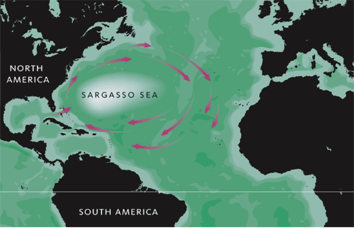
Remember the seaweed I wondered about in an earlier post?  It is called Sargassum.  It grows in rafts in the Sargasso Sea.  This is actually where the Sargasso sea got its name.  According to NOAA’s National Ocean Service, these rafts provide habitat for certain fish and marine life.  Turtles use them as nurseries for their hatchlings.  In recent years large blooms of Sargassum have been washing up on nearby coastlines causing problem along the shore.  (Oct 1, 2014, USA Today)  More research needed!  There are always more questions.  Is this caused by warming oceans, by oil spills, or by a combination?  Nothing lives in isolation.  All life forms are connected to each other and to our environment.  Changes in the ocean impact us all, everywhere on the globe.

A Sargassum Mat. Photo courtesy of NOAA.


Want to explore yourself?  Check out NOAA Corps to become ship officer!

Career Profile of a NOAA Corps Officer:

Acting Executive Officer (XO) Lieutenant Fionna Matheson is augmenting on this leg of the trip, meaning she is filling in for the XO currently on leave.  Otherwise, in her current “land job” she works at NOAA headquarters for the NOAA Administrator, Dr. Kathryn Sullivan.  Dr. Sullivan, a former astronaut and the first American woman to walk in space, reports to the Secretary of Commerce, Penny Pritzker. Working on the headquarters team, LT Matheson learns a great deal about the breadth and importance of NOAA’s mission.

Lt. Fionna Matheson
Lt. Fionna Matheson

To become a member of the NOAA Corps you must have a Bachelor’s degree in Science or Math. It is a competitive process, so some sort of experience with boating is advantageous, but not required.  NOAA Corps officers are trained not only to drive and manage ships, but also to handle emergencies including fire-fighting, and follow maritime law.  They act as the glue between the scientists and the crew (wage mariners), making sure the scientific mission is accomplished and the safety of the crew and the vessel are secure.  Fionna has been part of the corps for 11 years.  She explains that NOAA Corps officers are stationed for about 2 years at sea (with some shore leave) followed by 3 years on land throughout their careers. During her NOAA career, Fionna has sailed in the tropical Pacific maintaining deep-ocean buoys, fished in the North Atlantic, collected oceanographic samples in the Gulf of Mexico, and now mapped part of the Caribbean. She has also worked as part of an aerial survey team in San Diego, studying whales and dolphins.

Fionna’s advice to high school students is this, “The difference between who you are and who you want to be is action.  Take the initial risk.”

Personal Log

What do we do for fun in our free time?

We read.

Jason Meyer, Mapping Watch Lead, reading on the Okeanos.
Jason Meyer, Mapping Watch Lead, reading on the Okeanos during his off hours.

We play games like chess, although I am not very good.  I try, and that is what is important, right?

Chess Tournament
Chief Steward Dave Fare and CO Mark Wetzler playing a warm up game before the chess tournament.

We watch movies – even watched Star Trek on the fantail one evening.   Very fitting since we are boldly going where no one has gone before with our high-resolution sonar.

Movie Night
Movie night on the fantail.

And we watch the sun go down on the ocean.

Sunset
A view from the fantail of the ship.

Mostly, I like watching the water when I have time.   I would have made a great lookout – I should look into it after I retire from teaching.  I have been trying to use my Aquaman powers to summon the whales and dolphins, but so far – no luck.   Maybe on the way back in to shore we’ll catch another glimpse.

What do I miss?

My family and friends.  Hi Bryan, Ben, Laura, Dad, Mom, and the rest of the gang.

My family
My family

And my students and coworkers.  Go Ashland Oredockers!

Ashland Public Schools, Ashland, Wi

I am fortunate to have such supportive people behind me!  Thanks, guys!

I do not miss snow and cold weather, so if you all could warm it up outside in northern Wisconsin over the next week, I’d appreciate it.  I’ll see what kind of strings I can pull with these NOAA folks!   ¡No me gusta la nieve o el frío en la primavera!

Did you know?

Sky conditions on the bridge are determined by oktas.  An okta is 1/8th of the sky.  If all oktas are free of clouds the sky is clear.  If 1-2 oktas contain clouds, the bridge reports few clouds, 3-4 filled oktas equal scattered clouds, 5-7 equal broken clouds, and 8 filled oktas means the sky is overcast.

Question of the Day

Theresa Paulsen: Getting my Hands Dirty with Data, March 24, 2015

NOAA Teacher at Sea
Theresa Paulsen
NOAA Ship Okeanos Explorer
March 16 – April 3, 2015

Mission:  Caribbean Exploration (Mapping)
Geographical Area:  Puerto Rico Trench
Date:  March 24, 2015

Weather from the Bridge:  Scattered Clouds, 26.6˚C, Wind 10kts from 100˚, Waves 1-2ft, swells 2-3ft

Science and Technology Log

Now that the interns have been trained in data collection and processing, it was my turn to learn.

Mapping Intern Chelsea Wegner taught me how to launch an XBT and how to process the data gathered by the multibeam sonar. It is a fairly simple procedure that requires diligent record keeping in logs.  I processed four “lines.” A line is about one hour of data collection, or shorter. Two of my lines were shorter because the sonar had to be turned off due to a whale sighting! This is bad for data collecting, but AWESOME for me! Again, I missed it with the camera, though.

Mapping Instructors
My Mapping Instructors: Intern, Chelsea Wegner; Expedition Coordinator, Meme Lobecker; and Mapping Watch Lead, Jason Meyer.

I have also been given the task of using a sun photometer to measure direct sunlight over the ocean as part of the Maritime Aerosol Network, a component of AERONET, a NASA project through the Goddard Space Flight Center.  Every two hours when the sun is shining and there are no clouds in the way of the sun, I use this tool to measure the amount of sunlight able to penetrate our atmosphere.

Using the Sun Photometer

I use a GPS to determine our location and transfer that information to the sun photometer.  Then I scan the sunlight with the photometer for about 7 seconds and repeat 5 times within two minutes.  Keeping the image of the sun in the target location on the photometer while standing on a rocking boat is harder than it may look!

Sun Photometer
The little bright light in the dark circle above my right hand is the image of the sun.  It must remain in the center of the traget circle during a solar scan.

According to the Maritime Network, the photometer readings taken from ground level helps determine the Aerosol Optical Depth, meaning the fraction of the sun’s energy that is scattered or absorbed while it passes through the earth’s atmosphere. The reduction in energy is assumed to be caused by aerosols when the sunlight’s path to earth is free of clouds.  Aerosols are solid or liquid particles suspended in the atmosphere.  Sea-salt is a major contributor over the ocean as well as smoke and dust particles from land that are lifted and transported over the oceans.  There are many stations over land that collect this data, but using ships is also important because the data is used to provide “ground truth” to satellite measurements over the entire earth, including the oceans.  The data is also used in climate change research and aerosol distribution and transport modeling.

Aerosols in our Atmosphere
“This portrait of global aerosols was produced by a GEOS-5 simulation at a 10-kilometer resolution. Dust (red) is lifted from the surface, sea salt (blue) swirls inside cyclones, smoke (green) rises from fires, and sulfate particles (white) stream from volcanoes and fossil fuel emissions.” (NASA,Goddard website)
Image credit: William Putman, NASA/Goddard

It is pretty cool to be part of such an interesting project!  The people here are interesting too.  I thought I’d highlight some of their stories in my next few blogs.

Career Profile of Intern Chelsea Wegner

Chelsea’s story is a great example for high school students.  She graduated from a high school in Virginia that is similar in size to Ashland High School, where I teach.  Her family enjoyed spending time near the ocean and had a library of books about ocean adventures.  Her grandfather served in the Navy on Nuclear Submarines and liked to build models of ships.

Chelsea Wegner reading "My Father, the Captain:  My Life with Jacque Cousteau"  by Jean Michel Cousteau  in her free time.
Chelsea Wegner reading “My Father, the Captain: My Life with Jacque Cousteau” by Jean Michel Cousteau in her free time.

In high school, her career interests began to take shape in her Environmental Science in Oceanography class.   She went to college at the University of Mary Washington in Virginia majoring in environmental science with particular interest in geology and river systems.  She took advantage of a research opportunity studying sediment transport from rivers to the coast during her undergraduate career.  She took sediment core samples and analyzed them to determine human impacts, contamination, and dated the sediment layers.  She took more research courses that took her to the US Virgin Islands to conduct a reef survey, identifying and counting fish.  She described that as a pivotal experience that led her toward her Masters Degree in Marine Science.  Her Masters thesis project was a coastal processes study the potential effects of sea level rise on coral reefs and the corresponding coastline.  She used the connections she had in the US Virgin Islands and in her university to fund and/or support her research.

After competing her Masters Chelsea applied for a marine science and policy fellowship, the Knauss Fellowship, which allowed her to work as an assistant to the Assistant Administrator of Oceanic and Atmospheric Research (OAR) within NOAA, Craig McLean, for one year.  Through this fellowship, Chelsea traveled the world to places like Vietnam, the Philippines, New Zealand, and France getting a first-hand look at how science informs marine policy and vice versa.

Chelsea learned early on that experience matters most when trying to make yourself marketable.  That is why she is here now serving as a mapping intern.  She takes the opportunity to learn every piece of equipment and software available to her.  She is a rising star in the world of science.  After this voyage, she will begin her new job as a program analyst at OAR headquarters working in the international office handling engagements with other countries such as Indonesia and Japan.  And she is only 28!

Did You Know? 

At 10 AM this morning there was tsunami drill, LANTEX (Large Atlantic Tsunami Exercise) on the east coast from Canada all the way down to the Caribbean.   So students in schools inside Tsunami-threatened areas likely participated in evacuation drills.  The test is part of NOAA National Weather service Tsunami Warning Program.  It helps governments test and evaluate their emergency protocols to improve preparedness in the event of an actual tsunami.

Question of the Day

Theresa Paulsen: A Vessel Built on Science, March 23, 2015

NOAA Teacher at Sea
Theresa Paulsen
Aboard NOAA Ship Okeanos Explorer
March 16 – April 3, 2015

Mission: Caribbean Exploration (Mapping)
Geographical Area of Cruise: Puerto Rico Trench
Date: March 24, 2015

Weather Data from the Bridge: Scattered Clouds, 27.0˚C, waves 1-2ft, swells 3-4ft, wind 11kts from 100˚

Science and Technology Log

A ship like the Okeanos Explorer demonstrates the connection between science and engineering to the nth degree.  Every room that I visit and every person I talk to can illustrate scientific applications.

Okeanos Explorer
NOAA Ship Okeanos Explorer. Image courtesy of NOAA Office of Ocean Exploration and Research.

Consider the galley I introduced you to in my second blog post.  On a three-week cruise with no access to a grocery store, how are the cooks able to serve fresh fruits and vegetables?  I assumed that they would have to serve canned or frozen foods as time went on but that is not the case.  The Chief Steward, Dave Fare, tells me that he or a member of his crew, goes through the produce each morning to pick out anything that is past its prime so that the any ethylene emitted by the offending overripe items won’t affect the other fruits or vegetables. So far the food has been fabulous so it must be working!

Salad bar
Check out the salad bar available every day!

Then of course, you have the clean up where dishes are rinsed, washed, rinsed again, and then sanitized in a high temperature dishwasher to kill off any harmful bacteria.  Biology in action. They occasionally add beneficial bacteria treatments to the drains to help break down any organic matter that makes its way into the drain pipes.  This reduces the unpleasant smell of decaying matter and makes the water cleaner.

Where does that water go?  I took a tour to find out.

Engine Room Tour
Ready for an Engineering Tour!
First Assistant Engineer
My tour guide, First Assistant Engineer, Ricardo Gabona

The water that goes down the drain or gets flushed goes through an onboard wastewater treatment process similar to one used by a city but in miniature form. It is macerated (ground up), filtered, and then treated with just enough chlorine to kill harmful bacteria before leaving the ship.  The ship’s First Assistant Engineer, Ricardo Gabona, told me that the effluent (water leaving the ship) looks as clean as the seawater we are sailing on with less than 15 ppm total dissolved solids.

Wastewater Treatment Unit
The Ship’s Wastewater Treatment Unit.

How do we survive without additional freshwater for drinking?  We don’t have to!  We are actually drinking seawater – after it has been distilled.  It is a pretty cool process.  The water used to cool the engines, absorbs enough heat to raise the temperature to about 180˚F.  Using a vacuum, the pressure of the water from the engines is reduced so that it boils at temperatures as low as 150˚F.  Next the vapor is condensed.  There you have it – distilled water!  That is great energy conservation in action!  The water then has to be cooled, before heading to the faucets with a heat exchanger.  No need for a water heater – the engines do the work!  The distilled water is also filtered and run through an ultraviolet light tube twice just to be sure to kill off any remaining microbes.  The distillers can make water at a rate of about a gallon per minute.  There are two of them on the ship.  So can you calculate how long it would take them to make enough water for the maximum 46 people on board, each using 50 or more gallons per day?

Vacuum Distinller
Vacuum distiller for the desalination of sea water

In order to draw in relatively clean sea water, the ship must be at least 20 miles from shore, according system’s manufacturer, to avoid contamination from erosion and runoff. For us this means we need to transit north periodically to make water, disrupting our planned mapping route. Water conservation is a priority on this cruise to avoid that as much as possible.

Check out our mapping progress!  You see, the vertical paths were taken when we needed more water.

Our mapping path so far
Our mapping path is represented by the red line in this window. The black outline is Puerto Rico.
Bathymetry data collected so far
Our path looks much cooler with the bathymetry data added, doesn’t it?

What about fuel?

According to Ricardo, the ship was originally built as a submarine hunter during the cold war.  It’s mission was to listen for and locate Russian submarines.  It carried a crew of 24 sailors for 6-9 months at a time. NOAA took charge of the ship in 2004 and by 2008 had modified it to become the exploration vessel it is today.  Some of the fuel tanks now serve other purposes.  Currently the ship can hold 149,000 gallons of diesel fuel! The ship now has 26 crew members, but also now hosts teams of up to 20 scientists, which requires more power and energy.   Still the fuel can last more than 2 months.  The ship will need to be refueled before heading to the Panama canal en route to the Hawaiian Islands.

Why diesel?  It is a very safe fuel for ships, since it won’t ignite at standard temperatures and pressures.  But diesel can be dirty and can contain water, both can interfere with engine performance.  You don’t want to have engine trouble when you are out at sea.  So the fuel is cleaned with a fuel purifier and water separator that use a centrifuge to  separate the fuel from the contaminants based on density.  The fuel entering the engines goes through this process multiple times to ensure the engines are getting very clean diesel fuel.  As a result, you don’t see or smell the exhaust from the combustion.

Of course all of this fuel is heavy, as it is used, the ship would get lighter and lighter making it float higher and higher.  This would be a problem for stability.  As any object’s center of gravity rises higher, the object becomes less stable and more likely to topple.  You do not want your ship to topple!  So you need to replace the fuel as you use it with ballast water.  The fuel and ballast tanks are located all around the ship.  As the fuel tanks are emptied and water tanks are filled, the engineers must consider the balance of the vessel, ensuring the mass is distributed properly for optimum performance and stability in the water.

Personal Log:  

I am loving this adventure.  I am mesmerized by the massiveness of the ocean.  I love looking out at water as far as I can see with only a ship or two in the distance every now and then.   I could watch the water for hours on end.  You see interesting things when you are really looking, each one giving you cause to wonder.  Consider the interesting birds that fly by.  What are they?  Where do they call home?  Why do they like to fly by the ship?  Why do flying fish fly?  Are they finding insects that I can’t see, or are they evading predators?   Where do all the seaweed patches floating on the water come from?  What kind of seaweed is it?  Is it edible?  Do they grow there at the surface, or are they floating debris carried out to sea, or is it a combination of the two?

Let’s start with the birds.  Lieutenant Emily Rose, Operations Officer, told me they are brown boobies.  Take a look at these photos taken of the bow of the ship.

A Brown Booby
A Brown Booby
Brown Boobies
Brown boobies often maintain mating pairs for several seasons
Brown Booby in Flight
Brown Booby in flight

Did You Know?

According to Wikipedia, brown boobies nest in large colonies in tropical areas like the Caribbean and the Gulf of Mexico.  They very good fliers that can plunge for fish at very high speeds, but they are clumsy at take off and landings as we observed on the bow this morning.  One of the birds tried to land on the railing and slipped. Junior Officer Bryan Pestone had to help him up and over.  He flew away for a short time and then returned.  My guess is they use the vantage point of the ship to watch for small fish and to preen themselves.

I’ll let you know what I find out about the seaweed and flying fish in future blogs.  ¡Hasta Luego!

Question of the Day

Theresa Paulsen: And We’re Off! March 17, 2015

NOAA Teacher at Sea
Theresa Paulsen
Aboard NOAA Ship Okeanos Explorer
March 16 – April 3, 2015

Mission: Caribbean Exploration (Mapping)
Geographical Area of Cruise: Puerto Rico Trench
Date: March 17, 2015

Weather Data from the Bridge: Partly Cloudy, 26 C, Wind speed 12 knots, Wave height 1-2ft, Swells 2-4ft.

Science and Technology Log

Elizabeth “Meme” Lobecker, Physical Scientist Hydrographer with the NOAA Office of Ocean Exploration and Research and our Expedition Coordinator, gave the science team aboard the vessel an overview of our expedition on Sunday after an evening of becoming acquainted with the ship and other members of the science team.

Meme Lobecker
Elizabeth “Meme” Lobecker, Expedition Coordinator from the NOAA Office of Oceanic Exploration Research (OER)
Mapping Introduction

She explained how oceanic exploration research is different from the rest of the scientific community and even other projects within NOAA, because it focuses purely on exploration and discovery that can generate hypotheses. In other areas, a scientist has a hypothesis first and sets out to test it through research and experimentation.

The information gained on our mission could generate hypotheses in all kinds of areas of research such as geology, fisheries, oceanography, marine archeology, and hydrography. It could help us identify areas that need protection, such as spawning grounds for commercial fish populations.  Meme and her team will turn the data over to the National Coastal Data Development Center within three weeks. From there, it goes to the National Geophysical Data Center and the National Oceanographic Data Center, where it is freely accessible through public archives within 60-90 days of the end of the cruise.  From there, any entity, public or private, can access the data for use in their work. Have you ever wondered how Google Earth and Arc View GIS get the background data for their ocean floor layer? This data contributes to those layers. Now you know! Public data access is through www.ngdc.noaa.gov and www.nodc.noaa.gov.

While we currently have low resolution data from satellites, less than 5% of the oceans have high-resolution images. We have better data now about the features of Mars than we do about our oceans on earth. Why? Because ocean surveying is difficult and time-consuming. High resolution maps cannot be made of the ocean floor with current technology on satellites.  The technology is getting better and better, though. The image below shows the progression from a leadsman dropping a 10 pound weight attached to a line in the water to the multibeam sonar being used as I type.

Developing Hydrographic Survey Techniques.

Learn more about the history here.

The multibeam sonar aboard the Okeanos Explorer sends out a ping at 30 kHz that bounces off the seafloor and returns to the transducer that is equipped with sensors oriented in 432 different directions receiving up to 864 beams per swath. This method has been tested in depths of up to 8000 meters. It can give us not only bathymetry data, but also water column backscatter and bottom backscatter data. This allows us to know if there are features in the water column like gaseous seeps escaping from the ocean floor. We can also tell something about the surface features, whether they are soft sediments or hard rock, from the bottom back scatter.

Meme has a crew of mappers working with her including Scott Allen, Senior Survey Technician;  Melody Ovard and Jason Meyer, Mapping Watch Leads; and several interns. Another important part of the mission is to train a new generation of ocean explorers. These interns, Chelsea Wegner, Kristin Mello, and Josue Millan, come from colleges all over the country.  Their main job is to make sure the data is good and to create logs to document data collection.  They have to correct the multibeam sonar data by deploying XBTs (Expendable Bathythermographs) that determine the temperature changes within the water column because sound speed increases as water temperature increases.  They also use sensors on the ship to measure the conductivity and therefore determine the salinity of the water.  Since sound waves penetrate saltier water more easily, the salinity affects the sound intensity measurements.  Pressure must also be calculated into the equation because sound speed also increases with increasing pressure.

XBTS launch
Josue Millan launching an XBT

The vessel’s attitude also has to be factored into the sonar (like teachers need to factor in student attitudes when planning a lesson!) Similar to an airplane, a boat can pivot on its center of gravity in all three-dimensional axes: Pitch, Yaw, and Roll.  Think about your own head.  Pitch is like nodding your head in agreement, yaw is like shaking your head to say no, and roll would be like putting your ear to your shoulder.  Gives new meaning to the phrase “Heads are going to roll,”  doesn’t it?  Boats also heave, or move up and down as swells pass beneath them.

Mapping Data Collection Screen
This screen shows the data being collected by the mappers.

The screen shot above shows the data as it is being collected by the mappers.  In the main window in the upper right is the bathymetry data.  Below that is the water column backscatter.  In the bottom left is the attitude of the vessel on all axes.   The center left gray image shows the bottom backscatter while the number 421 above is the current depth beneath the vessel.  Finally, the display on the top left indicates the quality and intensity of each of the 432 beams.

We also have a team of researchers from the University of Puerto Rico that are deploying free vehicles to study water masses within the Puerto Rico Trench. More about them in the next blog!

Safety First!    On Monday, we had our first drills as part of our safety training. We practiced the “Abandon Ship” and “Fire” drills. We tested the fire hoses and donned our gumby suits. Mrs. Paulsen is looking pretty good, eh? It is comforting to know I’ll be well-protected by good equipment and a great crew in the event of an emergency.

Kristin Mello and Theresa Paulsen in their gumby suits during the first "Abandon Ship" drill.
Kristin Mello and I are trying out our gumby suits during the first “Abandon Ship” drill.
Fire hose test
Chelsea Wegner testing a fire hose.

After mapping all morning, we learned we had to return to port due to a medical issue. I discovered that engineers are vital to the operation. Without them, we don’t sail – and they are hard to come by.  All of my students interested in marine engine repair should consider NOAA in the future. The pay is good and the adventure is awesome!

I took the time in port to work in the galley helping to make lunch with the chefs. They are a friendly bunch. We made fajitas of all kinds and swordfish. Delicious! I also learned how to garnish a buffet line and even washed dishes afterward. In my high school and college days I worked in many restaurants, but they never let me work in the back. They said I was too much of a “people person” and so I was always waiting on customers. Today I got to cook on one of those large grills I see on cooking shows. Fun to cook on, but not fun to clean. The Chief Steward, Dave Fare, said he brought 5000 lbs of food on board for our trip! We’ll be eating well! Good thing there is a fitness room on board too!

Ranier Capati, Chief Cook showed my how to garnish a line.
Ranier Capati, Chief Cook showed me how to garnish a line.
Cooking in the Galley.

Personal Log

After training on Sunday I had some time to take in a little of the history and culture of San Juan, Puerto Rico. It is a lovely place filled with beautifully colored buildings and fun music. The history is fascinating. According the National Park Service, this is where Chrisotopher Columbus landed on his 2nd voyage and laid claim to the land for Spain. Under Juan Ponce de Leon, Spain took control of the island, displacing the Taíno Indians in 1508. An enormous wall of defense was built to keep hold of the island. Trade winds and ocean currents allowed ships to easily sail here from the east. The fortifications on the island took 10 generations to build.

This slideshow requires JavaScript.

Spain kept control of the island against invaders until the Spanish-American war in 1898 when Puerto Rico became a US Territory. The fortress including the Castillo de Felipe del Morro and the Castillo San Cristobal are now historical sites managed by the National Park Service. You can learn more here.

After touring the city, I found my way to the sea! I watched children running from the waves.  This reminded me of my childhood. My father used to take us to the coast when we lived in California and Oregon. That is where my love of the sea began. Both of my parents have adventurous spirits and strong work ethics. They taught me that anything is possible if you are willing to take the chance and put in the effort. This is a belief I hope I pass on to my students.

Question of the Day

Can you identify this crustacean I found along a beach in San Juan?

Crab on the beach of Sn Juan.  Can you classify it?
Crab on the beach of San Juan. Can you classify it?


David Murk, Tick Tock . . . . Okeanos, April 28, 2014

NOAA Teacher at Sea

David Murk

Aboard NOAA Ship Okeanos Explorer

May 7–May 22, 2014


You won't believe the images this ROV sends back!
You won’t believe the images this ROV sends back!

Okeanos Live Feed

The duty of the right eye is to plunge into the telescope, whereas the left eye interrogates the microscope” ― Leonora Carrington

WHERE I’LL BE:
Have you seen the video from the ship Okeanos? The Okeanos Live Feed  is astounding and will draw you in, so give yourself a little time to absorb the privilege of ‘swimming’ 6000 feet below the ocean’s surface. You will hear in real time, biology/geology experts on the ship and scattered around the globe, sharing their opinions regarding the HD footage from miles below the surface. We live in such an amazing world that can be put under the microscope, telescope, replayed, enlarged and viewed ad infinitum. We have instant access to ultrasounds from our unborn babies, the slow motion HD replay of that Stanley Cup winning goal, the frivilous youtube video, the Hubble, and swipes through a loved one’s phone pictures. The fact that we can sit in our landlocked cubicles and watch as the Okeanos scientists discuss and decipher the unexplored underwater canyons is mesmerizing. There are so many times in our lives that the promises of technological advances are useless and unfulfilled, but the wealth of knowledge aboard the Okeanos and the instantaneous sharing of the science via the ship’s telepresence is a dream realized. I will be aboard the Okeanos Explorer during most of the month of May. Our mission will include using the ship’s multi-beam deep water sonar capabilities to map some exciting Atlantic Canyons off the coast of Florida, making a long transit all the way up the East Coast, and working with scientists at the National Marine Fisheries Service on potentially discovering new spawning grounds for the threatened bluefin tuna.

WHAT I’LL MISS:

Hampshire Elementary School

The desire to explore is deeply woven into the fabric of all people, especially children. It is a privilege to spend my days teaching and exploring with 30 of the best ten and eleven year olds to ever walk the face of the earth. They work hard and are kinder than necessary. I am fortunate to teach with a phenomenal staff in the wonderful supportive community of Hampshire Elementary School. Hampshire, Illinois is a small town (population 5600) surrounded by an ocean of corn and bean fields. After a 30 minute drive east on a clear day you can just make out the top of the John Hancock Building and the rest of the skyline of downtown Chicago.

There is a combination of old and new at Hampshire Elementary. Many of the students’ parents attended this school and that lends an attitude of trust and support between faculty and parents. We as teachers appreciate that and there isn’t any desire to transfer to other schools in the district. On these warm spring days, the bike racks outside the school fill up and parents may let their children walk up town to Chicken Dip for a cone. While there are many “old school” attributes to our school, we also keep up with the new technologies. All of our classrooms have interactive white boards and teachers have personal laptops. The students have nearly constant access to two computer labs and a high percentage have internet access in their homes. I teach fifth graders; actually, we teach each other and I try to facilitate that. I have taught for a few years now. . . . since 1980! My favorite thing about a classroom is watching the students solve problems. One of the problems that I hope to help them solve is how our actions in the Midwest affect our planet’s oceans. I want them to see firsthand how things we put in our streams and atmosphere in Illinois can eventually affect the reefs and spawning grounds of organisms thousands of miles away. It is my hope too that one of these Hampshire Whippurs might someday be one of the NOAA scientists who make a key discovery that allows economic development without destroying fragile habitats.

I will also miss my four children during the busy month of May. I will miss Mollie moving out of her dorm and arriving home from Hope College, Sophie’s role in Prairie Ridge High School’s performance of “Sixteen and More”, Izzie’s performances in Spoghtlight Theater’performance of “Willy Wonka”, and (hopefully) a lot of Chicago Blackhawk’s playoff games with my son, Owen.

FOUR fine kids
FOUR fine kids

WHERE I’VE BEEN:
Living a thousand miles from the ocean is not where I thought I’d live when I was a boy. I loved the sea and always thought I’d live on the shore. When I was young, my family traveled back to my birthplace in Ireland by ship. I was quite happy to stand at the stern for hours and watch the wake disappear into the horizon. During the summers, when we’d go camping in Florida or Cape Cod, it was always the ocean that drew my interest. When teaching in Coventry, England on a Fulbright Teacher Exchange, I went to the coast in Eastbourne or Wales as often as I could afford. Now, camping with my own children along the shores of Lake Michigan at Pentwater and Warren Dunes has to suffice for a “seaside experience” though there is something so much more intoxicating about the salt water breezes. It is a lifelong goal to spend an extended time out at sea. To combine that with teaching is an incredible privilege. Thank you to NOAA, my family, and my WONDERful students and friends.