Mission: Oceanographic and Biological Monitoring of Davidson Seamount Geographic Area of Cruise: Monterey Bay National Marine Sanctuary Departure Port: Alameda, CA Arrival Port: Alameda, CA
Date: July 9, 2025
Yes, I am back for a second chance! Last year, after a wonderful orientation at the Coral Lab in Galveston, I unexpectedly came down with Covid just days before my cruise on Thomas Jefferson. Thanks to the Teacher at Sea Program and specifically the support of Emily Susko, I was placed on a new cruise on Reuben Lasker in the Monterey Bay National Marine Sanctuary. I am so grateful for this chance to sail and learn in my local marine sanctuary. Easier yet, the port of departure- Alameda- is just a 20 minute drive from my home in Berkeley!
In this cruise, the Monterey Bay National Marine Sanctuary (MBNMS) will be working with Point Blue Conservation Science and the Monterey Bay Aquarium Research Institute to study the Davidson Seamount. The Davidson Seamount is an undersea mountain that rises 8,000 feet above the sea floor and hosts a unique ecosystem due to the nutrient rich waters that are pushed to the surface. It is located 50 miles offshore of central California. I am very excited to learn more about seamounts!
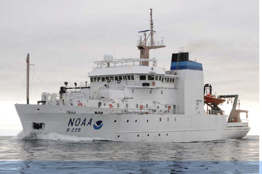
In our survey, we will sample the water above and adjacent to the seamount. We will also be surveying marine mammals and seabirds and their prey and collecting environmental DNA (eDNA) to understand animals that we are not able to observe. This data will help give a more complete picture of oceanography and biology of the entire seamount from its base to the ocean surface and help us to understand connections between climate, ocean conditions and marine life. One goal is to use this data to inform the shipping industry so that ships crossing the Davidson Seamount lower their speed to avoid hitting whales. This work is of great importance to me as I have been saddened by the many whale strikes in the Bay over the recent months. All of our work will be done on board Reuben Lasker, a 208 ft research vessel equipped for both fishery and oceanographic research.
NOAA Ship Reuben Lasker, Photo courtesy of NOAA
While I shared my background in my introductory blog last summer, there have been some new developments. First is the great news that after 9 years of leading student activism to end single use plastics in school meals, we began reusable dishware for school lunch. The change is not just for my school, but will be rolled out in all schools across the district, impacting 9,000 students daily and vastly reducing the plastic waste our schools generate. I am really happy that students will be able to experience more sustainable meals at school — since lunch is school too.
Traditional single-use disposable materialsNew reusable lunch dishes
This school year, I also had the opportunity to travel for 12 days to Antarctica as a Grosvenor Teacher Fellow with National Geographic on the polar expedition ship Endurance. This life-changing experience of exploring the Southern Ocean deeply impacted both myself and my class. We spent the school year diving into a study of Antarctica, interacting with polar scientists and learning of the critical role Antarctica has for the health of our water planet. We discovered how our local actions impact the environment and affect places as far away as Antarctica.
Though I couldn’t take my students on the voyage with me, I did instill in them the curiosity and joy I experienced exploring. Thus, my class became explorers of our local environment — the Berkeley Marina and the San Francisco Bay. In a series of 10 field trips, we learned to identify local birds, trawled and studied plankton and charted and sailed a course on the schooner Pegasus, engaged in multiple beach clean-ups (with data sheets) and camped on the cliffs in Marin overlooking the Pacific Ocean. I hope that through these joyful experiences of learning in nature, my students will be inspired to continue to grow their connection, curiosity and sense of caring for our planet — and especially for our ocean.
The following photos are included courtesy of Oxford Elementary.
Bay scientist studies Trawling as Bay Scientists Beach Clean / Waste Audit Birding at the Berkeley Marina
Sailing on Pegasus (a youth sailing project)
Charting a course to Angel IslandSailing our course to Angel Island
Finally, I am especially excited for my Teacher at Sea experience because Monterey Bay is close to my heart. In 2019, my students and I participated in the Monterey Bay Aquarium’s Ocean Plastic Pollution Summit; it was a life changing 2-day experience where we explored the aquarium at night, slept next to the tanks, listened to inspirational youth ocean activists and connected with students from all over California who were also working to solve the plastic pollution crisis. Many of the students pictured below are still active in working to protect our ocean by volunteering at the Marine Mammal Rescue Center or serving as youth representatives on our city’s Climate Commission.
Ocean Plastic Pollution Youth Summit. Photo courtesy of Monterey Bay Aquarium
As I embark on this voyage of discovery, learning and adventure, these words of the great oceanographer and ocean activist Sylvia Earle, whom I deeply admire, come to mind:
“The ocean is the cornerstone of Earth’s life support system, it shapes climate and weather. It holds most of life on Earth. 97% of Earth’s water is there. It’s the blue heart of the planet — we should take care of our heart. It’s what makes life possible for us.”
With Sylvia Earle and my students (not pictured) in Alameda, CA
Thank you to the scientists and crew of Reuben Lasker for the opportunity to join you in this most important work!
Mission: Applied California Current Ecosystem Studies Survey (ACCESS)
Geographic
Area of Cruise: Pacific
Ocean, Northern and Central California Coast
Date: July 24, 2019
Applied California Current Ecosystem Studies (ACCESS) is a joint research project conducted by NOAA (Cordell Bank National Marine Sanctuary and Greater Farallones National Marine Sanctuary) and Point Blue Conservation Science.
NOAA’s Office of National Marine Sanctuaries manages 13 sanctuaries and two marine national monuments, protecting a total of 600,000 square miles of marine and Great Lakes waters within the United States. Four of the sanctuaries are in California. Greater Farallones National Marine Sanctuary (GFNMS) is a large sanctuary that protects over 3,000 square miles of California coast and offshore marine habitat from San Francisco to Point Arena. There are numerous beaches and costal habitats included in this sanctuary, as well as the Farallon Islands. Cordell Bank National Marine Sanctuary (CBNMS) is a smaller sanctuary around Cordell Bank, a large offshore seamount approximately 22 miles from the coast. Sitting at the edge of the continental shelf, Cordell Bank is approximately 26 square miles in size, and while you cannot tell it is there from the surface, it supports a huge diversity of brightly colored sponges, corals, anemones, and other invertebrates. Both sanctuaries protect a wide variety of living organisms across the food chain, from phytoplankton to blue whales.
Map of Cordell Bank and Greater Farallones National Marine Sanctuaries.
Map taken from cordellbank.noaa.gov
Point Blue Conservation Science is a
non-profit organization that is working to combat climate change, habitat loss,
and other environmental threats by helping to develop solutions that benefit wildlife
and people. They work with local natural
resource managers (like National Marine Sanctuaries) to help monitor and
improve the health of the planet.
Scientists
from each of these organizations have come together to work on ACCESS.
This project, started back in 2004, collects data on the physical conditions
and living things within GFNMS and CBNMS.
Scientists use this data to document wildlife abundance, monitor changes
over time, and help inform decisions about conservation efforts. For example, data collected on the location
of whales can help create policies to reduce threats to whales, like ship
strikes and entanglements. There are
many huge ships that come in and out of San Francisco Bay on a daily
basis. Scientists are currently working with
the industry to support a reduction in ship speed, which can reduce the likelihood
of whales coming into dangerous contact with ship hulls. Another threat to whales are entanglement in
fishing gear. Legal commercial crab
fishing using crab pots occurs within the sanctuaries. In recent years there have been greater
incidents of whales being entangled in the buoy lines that fisherman use to help
them collect the crab pots from the bottom of the ocean. As the result of a recent lawsuit filed by the
Center for Biological Diversity, the commercial crab season ended early this
year to try to help protect the whales.
Adult Common Murre. Photo: Dru Devlin
An interesting, and possibly concerning, phenomenon is being observed on our cruise. Kirsten Lindquist, the seabird expert on this cruise, has seen a great number of Common Murres on the water during our data collection observations. However, she has noticed a lack of chicks. Common Murres nest on rocky outcroppings and the chicks leave the nest 15-25 days after they hatch, before they are able to fly. The chicks then float on the water are fed by their parents for several weeks until they can feed themselves. Generally, at this time of year she would expect to see a large number of adult and chick pairings floating on the surface of the water together. Today we saw quite a few chicks floating with an adult, but this has not been the case during the other days on this cruise. It is unclear why there are fewer Common Murre chicks than are typically seen.
Did You Know?
Dani Lipski and me deploying the CTD, a device used to measure water conductivity, temperature, and depth. Photo: Jaime Jahncke
Scientists
use “conductivity” as a measure of how salty the ocean water is. If the water is relatively cold and salty
that is a sign of “good” upwelling conditions, meaning that the cold water from
the deep ocean is moving up over the continental shelf, bringing a high
concentration of nutrients with it. The
upwelling along the California coast is a main reason why there is such a
diversity of ocean life here.
Geographic Area: Papahānaumokuākea National Marine Sanctuary
Date: July 29, 2017
Location: 20 deg, 20.0 min N, 156 deg, 08.6 min W
Weather Data from the Bridge:
Scattered Clouds
Visibility: 10 nmi
Wind @ 23 kts from 65 degrees
Pressure: 1015.1 mb
Waves: 4 – 5 feet
Swell: 7-8 feet at 70 deg
Temp: 26.5 deg
Wet bulb: 23.5 deg
Dewpoint: 25 deg
Bonus Spiritual History Blog
On July 23, we briefly suspended our operations to help out fellow scientists camped out on the French Frigate Shoals (Lalo), located along the Northwest Hawaiian Island chain – about halfway between the northernmost main islands and Midway (Kuaihelani). The trip was brief, and we never set foot on terra firma, but with the help of the Big Eyes we could see something that we had not seen up close in 3 days – land.
Two nights prior, we finally crossed over to the Northwest Hawaiian Islands – a sacred and certainly mysterious (at least to me) area for the Hawaiian People. I was waiting with some anticipation for the moment we would cross into these waters. The entire Northwest Hawaiian Island chain and its surrounding seas are limited-access for the vast majority of seafarers; the waters are protected by a proclamation signed by President George W. Bush in 2006, and expanded by President Barack Obama in 2016. This Marine Sanctuary’s designated area begins near the start of the Northwest Hawaiian Island chain, and stretches all the way to the Kure Atoll (Hōlanikū), just past Midway Island (Kuaihelani). We were not permitted to cross into these waters until we had a permit, part of which included a component requirement of a briefing on the history of the area before we entered. ers Native Hawaiian Program Specialist Kalani Quiocho introduced us to this sacred ground during our pre-cruise training with this briefing on this Marine National Monument, Papahānaumokuākea. His presentation was so moving that I felt it necessary that the story of these waters (through my limited experience) must be told.
Mr. Quiocho’s presentation began with the name song for Papahānaumokuākea. His voice bellowed out in an ethereal chant – one in a smooth and haunting language with sound combinations like nothing I had ever heard before. His song was punctuated with ‘okinas and kahakōs, and accented with stunning photographs of ocean life, ritual, and artifact. The music moved me to a tear, though I couldn’t quite pinpoint the emotion that was supposed to accompany it.
The Name song for Papahānaumokuākea, reprinted with permission from Kalani Quiocho.
I realize now that I have traveled to this sacred place that it was one of simple reverence for the culture and its people who belong so fully to it. It was at that moment that I realized that this trip would be a whole other ball game – one that is sacred, cosmic, and mysterious.
Papahānaumokuākea (pronounced Papa-hah-now-mow-coo-ah-kay-a) is the first officially designated Mixed Cultural and Heritage site, and is the largest fully protected conservation area in the United States. Its name commemorates the union of two Hawaiian ancestors – Papahānaumoku and Wākea, who according to Hawaiian ancestry gave rise to the Hawaiian archipelago, the taro plant and the Hawaiian people. These two ancestors provide a part of the Genesis story for Hawaiʻi – land to live on, food to eat, and people to cultivate, commune, and thrive as one with the gifts of their ancestors. The namesake alone of this marine sanctuary highlights the importance of its existence and its need for protection. Many of the islands are ancient ceremonial sites, two of which we passed on the way to the Shoals (Lalo).
Crossing over to the Northwest Hawaiian Islands also marks a celestially significant line in the Hawaiian archipelago – the Tropic of Cancer. The Tropic of Cancer is the furthest north that the sun will reach a direct overhead path during the solar year – you might know this as the summer solstice. Right on the Tropic of Cancer lies the island Mokumanamana, a sacred place of cultural distinction for the Hawaiian people. The Tropic of Cancer divides the entire Hawaiian archipelago into two distinct sections, Pō and Ao – the Ao represents the more southern islands and spiritual daylight, and thePō representing the Northwest Hawaiian Islands and spiritual twilight.
This diagram shows the separation between the NWHI and the main Hawaiian Islands. The horizontal line through the center divides day (Ao) from night (Pō) and lines up with the Tropic of Cancer. The Island Mokumanamana lies directly on the boundary between the living and spiritual realms. Our destination was Lalo, or French Frigate Shoals, though our travels took us much further northwest than that. (Diagram Credit: Kalani Quiocho)
The crossing over as we passed Mokumanamana is significant in that we entered a different spiritual zone of the Hawaiian Islands. The Papahānaumokuākea Marine National Monument’s website (clickhere to read much more about it) describes the Northwest Hawaiian Islands as “a region of primordial darkness from which life springs and spirits return after death.” In this sense, transiting past Mokumanamana represented a “crossing over” into a different realm of ancient history. Mokumanamana is known for its high density of ancient ceremonial sites and is considered a center of Hawaiian religion and ideology. Mr. Quiocho expands on the geographical importance of the area to the Hawaiian people in his commentary stating that,
“Papahānaumokuākea encompasses the Northwestern Hawaiian Islands which is ¾ of the Hawaiian archipelago and includes high basalt islands and low-lying atolls, and surrounding marine environments. It stretches nearly 2,000 kilometers and straddles the Tropic of Cancer also known to Hawaiʻi as Ke Ala Polohiwa a Kāne – The sacred black glistening path of Kāne, the patron god of the sun. It is believed that the Hawaiian Archipelago is divided into two regions called Pō and Ao, which essentially means night and day. Most of the NWHI is within Pō, a place of creation and origin where ancestors return to after death. The region known as Ao includes the main Hawaiian Islands where man resides. The entire Hawaiian Archipelago represents the dualisms and cycles of the Hawaiian universe. From the east where the sun rises and the islands are volcanically birthed from the oceanic womb to the west where the sun sets and the islands return to the sea. And all of the extraordinary biology that is found in the Northwestern and main Hawaiian Islands are accounted for in our oral traditions. The Kumulipo, a creation chant with more than 2,000 lines expresses the cosmology of the Hawaiian Islands, beginning with the birthing of the coral polyp and eventually the Hawaiian people. Naturally this is an inspiring place that is the framework of our worldview and the knowledge systems that tell us we are people of place. Which is why many refer to this area as the kūpuna islands, kūpuna meaning elder or grandparent.”
Today, Native Hawaiians will travel by double-hulled canoes from the main islands all the way up to Nihoa and Mokumanamana during times of ritual importance and follow in the footsteps of their ancestors to honor the tradition and the spiritual practice. I’m sure the journey is both treacherous and fulfilling, one that would rival other more commonly known great expeditions, especially considering its spiritual significance.
Papahānaumokuākea is rich with history – both ancient and recent, and full of its own surprises!
Mr. Quiocho continues by expanding on the importance of the navigation of these waters to the Hawaiian people and how it honors their homeland connections:
“Native Hawaiians believe that the vast region that makes up the NWHI is an incredibly sacred place and is regarded as the construct of their cosmological genealogy. This region is rooted in creation and origin as a place where all life began and to which ancestors return after death. Native Hawaiians have historical connections to all parts of their homeland, which encompass all the islands, atolls, shoals, coral reefs, submerged seamounts and ocean waters that connect them. While the islands themselves are focal destinations for traditional voyages, the vast ocean is equally important. It is a cultural seascape that is imbued with immense value. The ocean is more than an unknown empty space that isolates islands, but rather a pathway for movement and potential.
A rare sighting of Tropical Pacific Orca – one of the first Cetaceans to welcome us to the Monument. What a gift!
Long-distance voyaging and wayfinding is one of the most unique and valuable traditional practices that Native Hawaiians have developed and continue to advance. It is an ancient way of interacting with the ocean that continues to inspire and create social change. The ocean region surrounding the NWHI is the only cultural voyaging seascape within the Hawaiian Archipelago. The main Hawaiian Islands are large enough for any novice navigator to find, but the ocean region throughout and surrounding Papahānaumokuākea provides challenging opportunities for apprentice navigators to excel. This expansive ocean environment was the setting for ancient Hawaiian chiefs to voyage back and forth between the main Hawaiian Islands and the NWHI over the course of 400 years.”
On our journey, we slipped passed Mokumanamana in the cover of night – through the invisible gates and into this ancient ancestral realm. Although we had been in the monument since the previous day, for some reason this crossing marked a distinction for me personally in an indescribable way. Since arriving on Oahu and in my travels since, I’ve known there was something special and different about this place, and I’ve known that part of the “different” was me. Walking through Ala Moana Park on the 4th of July revealed threads of a culture that formed a beautiful tapestry of family, community, and heritage as I strolled past hundreds of families camped out in anticipation of the upcoming fireworks over the ocean.
A volcanic neck stands high above the waters surrounding the shoals.
There was something communal and sacred about it, even though the time and event was modern. There was an “old” feeling of togetherness that buzzed through the park amongst strangers and friends. I knew I was an outsider to this energy, but I didn’t feel entirely left out of it. It’s one thing to feel like a foreigner on the “day” side of the Tropic of Cancer, but the “night” side held a spiritual distinction, as though I was trespassing in a dimension to which I did not belong. Knowing that the only passage of ships through this area would come with permits and regulations left a feeling of emptiness in an already vast ocean. Knowing the ocean is full beneath with life both current and past – fish and whale and ancient Hawaiian spirit alike gave back some reassurance that we were not entirely alone. For the first time I didn’t want to just know about Papahānaumokuākea, I wanted the ocean to tell me the story herself.
Nestled in the middle of Papahānaumokuākea was our target destination – French Frigate Shoals (Lalo). On this tiny island a small team of scientists have been camped out for a little over six weeks studying the endangered Hawaiian Monk Seal. We were tasked with delivering critical supplies to the scientific team – fuel, replacements of scientific gear, and a small care package with a few creature comforts they had not had access to in quite some time. (I mean, seriously. Who drops off fuel without dropping off chocolate? Not us!) We also picked up some specimens from them to take back to the lab in Honolulu. The Shoals are a special place – a World War II military outpost slowly decays on the far side of the island, providing some cover for the scientists as they work. The island hosts thousands upon thousands of terns, flying en masse around the island in huge swarms.
A closer view of the island. The dots in the air above the island are all birds.
The terns were in preparation of fledging, and in anticipation of that day, tiger sharks stalked the surrounding waters, waiting for their next meal. On the opposite side of the island a few hundred meters away from shore, a lone sandbar (formerly dredged up for use as a military runway) rose to the surface providing a quiet place for a monk seal and her two pups to lounge in the sand. One seal pup practiced swimming in the shallows as the mother casually glanced in its direction. The other pup would hobble a few feet away down the beach, only to run back to its mother and lie next to her for a time. It was a little reminiscent of a Norman Rockwell beach vacation painting, had Rockwell chosen an animal personification route as his medium. A turtle dotted the far edge of the landscape on the main island, basking in the rising sun as the waves gently rolled on to the beach behind him.
This flat strip of land is a dredged up runway, slowly returning back to the ocean after years of abandonment from use. A mother seal and two pups lounge on the sand, enjoying the sun.
The structures on the land from afar looked like a distant movie set for an apocalyptic storyline. The wind howled as we approached the atoll, and birds fought against the invisible currents in frantic circles around the island. Two boats lay destitute along the far side of the island while waves crashed merciless against the sea wall built to hold the atoll in place during the time the island was volunteered to serve in a wartime capacity. The island itself is a surreal duplicity – serving both as a protector of life and a vessel of war. I found myself taking stock of this history; watching from far away to learn the eternal evolution of this strange place – first a volcano, sunk beneath the surface, then to a primordial breeding ground for coral, fish, and shark – onto a pristine landscape, possibly used by ancestral Hawaiians for ceremony and stopover en route to Kure (Hōlanikū) – a military base as a refueling station and an outpost – and finally a protected home for hundreds of species, some hanging desperately onto the last strings of life but finally thriving under the care of a dedicated research team.
As much as I desperately wanted to go on to the island to have a look at this former military operations base-turned-endangered-animal-sanctuary, none of us could go on shore – even those who shuttled supplies to the scientists. French Frigate Shoals marked the first time I had ever seen a coral atoll in anything other than a picture, and it seemed a natural part of my inner explorer to want to pop on to shore to have a look about, even for just a few minutes. Everything in French Frigate Shoals is protected under the Papahānaumokuākea permitting restrictions.
Supplies were hauled ashore by the small pulley system jutting up from the shoreline – visible on the left-middle portion of the island.
Had we wanted to explore the land, we would have needed to quarantine our clothing and ourselves for a minimum of 72 hours to protect the landscape from anything foreign taking foot on shore. Our ship couldn’t make it much closer than a mile or two from the island so as not to put it in danger of running aground. So, a team of four people shuttled supplies in the small boat, navigating the shallows and hauling the supplies on shore through a pulley system. Two quick trips out to the island, and we were soon on our way again in our search for cetaceans.
When Mr. Quiocho parted ways with us after our training, he made a casual but powerful statement in closing. He told us the whale dives deeply to commune with ancient wisdom commissioned to the deep ocean, bringing this deep knowledge from the ancestral depths to the surface so that it can become part our collective consciousness. Our trip, then, is a not merely a collection of data or a series of samples. Each time we interact with the whales, they are bringing us the knowledge of the ancients in hope that we will continue to pass that information on to anyone at the surface willing to listen. The responsibility of our work when described in this light brought a new reverence to the study – one that is not just a story for the present in hopes of preserving for the future, but that weaves ancient knowledge from the past into our work, as well.
Did you know?
Each day at noon, the ship’s alarms are tested to ensure they will work in an emergency situation. Guess who got to test the alarms?
Yup! I got to test the alarm. Thanks Lieutenant Commander Rose!
Ship safety is the height of the focus of everyone on board. Each Friday, we complete drills to make sure we are ready in the event of an emergency. Of the many dangers at sea, a fire can prove to be most catastrophic. It’s not like the fire department can come out to the middle of the Pacific at the first sign of burning bacon (which may or may not have happened to me two days before I left for Oahu). The entire Sette crew acts as the fire department, so it is important for them to practice in the event of an emergency. This week we simulated a live-fire scenario, complete with a fog machine. I got to call the drill up to the bridge! It was a little extra fun built into a very serious situation.
Classes are still continuing each afternoon on the bridge, Monday through Friday.
Dr. Amanda Bradford gives the Wardroom a lesson on Hexacopter Operations (see blog #5 for more!)
ENS Tim Holland gives a lesson on MSDS chemical safety sheets.
Officers are in a friendly competition to see who is on watch when the most sightings occur, among other friendly battles. It is the topic of lively discussion at most meal times.
Officers can make a competition out of ANYTHING! Here are the tallys for the past 25 days.
NOAA Ship Bell M. Shimada, my home away from home for the next six days!
Science Log
Today marks my first official day aboard the Shimada as part of NOAA’s Teacher at Sea Program. NOAA stands for National Oceanic and Atmospheric Administration. My name is Sarah Raskin and I am an educator at Haydock Academy of Arts and Sciences, a public middle school in Oxnard, California. For the next week, I have the opportunity to join NOAA scientists from across the United States on a deep-sea science expedition in the Channel Islands National Marine Sanctuary. I am hoping to bring back what I learn to the students at Haydock and to paint a picture of what it is like to work on real-life science out in the field.
The scientists starting from the left: Peter Etnoyer, Rick Botman, Branwen Williams, Andrew Shuler, Erin Weller, Will Sautter, Steve Holz, Leslie Wickes, Andy Lauermann, Chris Caldow, Dirk Rosen, Mike Annis, Laura Kracker.
The location for our expedition is in the waters off of the coast of Ventura and Santa Barbara counties in Southern California. The Channel Islands National Marine Sanctuary (CINMS) covers 1,470 square miles of water surrounding Santa Barbara, Anacapa, Santa Cruz, Santa Rosa, and San Miguel Islands and is home to a large amount of diverse species. On this expedition, scientists will use an ROV (a remotely operated underwater vehicle) to examine deep-sea coral and the water chemistry around those coral beds. One of the most surprising facts for me before beginning this journey was to learn that coral grows in cold water deep-sea habitats, having only previously associated coral with warm water environments.
During this expedition, scientists will also look at how the corals are affected by ocean acidification. It will be interesting to see what their findings are: how do our actions on land affect organisms, such as coral, that live in the deep sea?
A Ventura County watershed: from the mountains to the sea.
Anacapa Island (Channel Islands National Park and Marine Sanctuary)
The scientists will collect live samples of the coral to take back to their labs for further ocean acidification testing. Throughout this trip, scientists will also use sonar to map the ocean floor. The information gathered from the sonar will help provide direction for where to send our ROV. The new images generated from the sonar could also be used to bring up-to-date sea floor maps of the Sanctuary, many of which have not been updated since they were created in the 1930s! Another feature of the sonar is to map out locations and quantities of fish populations in the area. This information is vital to sanctuaries and marine protected areas, as it contributes important information about why these areas are important to protect.
Science in the field is much different than science in a laboratory setting. There are so many factors to take into account: weather, ocean conditions, the working conditions of the equipment and many more unforeseen circumstances. The scientists and ship crew must each do their parts and work closely together as a team to make the research possible. During the first day aboard the researchers have faced quite a few challenges… Maybe because we set sail on Friday the 13th?
The morning began with impromptu safety drills. Similar to the fire drills that we have at our school, the ship also conducts regular drills. Today we had both a fire drill and an abandon ship drill. The abandon ship drill prepares the crew for an emergency event that would require us to leave the ship immediately. It also involved donning a safety suit, a giant red neoprene wetsuit that is designed to keep you warm if you needed to jump into the ocean.
Fire drill on the ship
A picture of me in the survival suit
Later in the afternoon, the team took the ROV out for its first outing of the trip. Chris Caldow (the expedition lead) and the scientists from Marine Applied Research and Exploration (MARE) chose a spot on the ocean floor that was sandy and flat with few physical features to snag on for its initial run. The ROV, which is named the Beagle, is an amazing piece of machinery. It is designed to be able to function in depths of down to 500 meters. It is also equipped with a high definition video camera that will take footage of what is going on under the sea. If the scientists see something of interest, the Beagle ROV has a manipulator arm to collect samples. The arm feature is also used to deploy different types of sensors that will keep track of information, such as temperature, over a longer period of time.
MARE (Marine Applied Research and Exploration) Beagle ROV
The launch of the ROV was exciting. Most of the crew gathered around to watch its release, and as it made it’s way down to the sea floor, it began streaming video footage to monitors inside of the laboratories on the ship. It was pretty incredible to be able to see the bottom of the sea floor with such clarity. So far, we have spotted multiple species of rockfish and an egg case of a skate. I can’t wait to see what tomorrow will bring!
Watching streaming video footage from the ROV
Back to one of our challenges: the key sonar machine is currently out of order. When things break on a ship, it can be a bit tricky to fix. It’s definitely not as simple as running to the nearest hardware store to pick up a new piece of equipment. When something is not working out here, it can involve scuba diving under the ship to fix something or sailing back to the mainland if there is a real issue. So tomorrow there will be a boat coming out to meet our ship and bringing with it equipment and a trained sonar technician to hopefully solve our problems. Let’s keep our fingers crossed!
Update: Science in the Field
The Beagle ROV journeyed into the depth once more last night. This time the mission was to find deep-sea coral beds, in particular one species called Lophelia pertusa, and bubble gum coral.
Lophelia pertusa
The MARE team (Dirk Rosen, Andy Lauermann, Steve Holz and Rick Botman) worked with scientists Peter Etnoyer, Leslie Wickes, Andrew Shuler and Branwen Williams to locate a coral bed that they had visited previously in 2010 and 2014. Using GPS coordinates, the MARE team was able to locate the exact site of the coral bed that Peter and his team had worked with in earlier years. There were quite a few high-fives and cheers of excitement in the lab when the ROV made its way to the familiar patch of bright red bubble gum coral.
Branwen and Dirk scout the sea floor for coral beds
The team dropped a temperature gauge at that location that will take and record a temperature reading every five minutes for the next six months. After that, Peter and his team will return on a second expedition to retrieve the device. The temperature gauge is tied to a rope attached to a lead weight and a flotation device covered with bright reflective tape. Andrew explained that the reflective tape would stand out in the headlights of the ROV, making it much easier to spot when they return for it half a year later.
Andrew holds up one of the temperature sensors that will be deployed with the ROV
The Beagle also retrieved its first coral sample of Lophelia pertusa, which it brought to the surface. Picking up samples from the deep in no easy feat. Andy and Dirk control the ROV from the deck with controls that look similar to something you would find on a video game consul. Sitting along side them, scientists Peter, Leslie and Branwen direct them to which coral specimens look the best for their sample. Then using either the manipulator arm or a shovel like feature on the boat, the ROV controller works quickly to scoop the organism into a basket attached to the front of the machine.
The scientists watch live video feed from the ROV
Once the ROV safely made it back on board, the scientists worked quickly to get the coral and its little inhabitants, such as deep-sea brittle stars and crabs, into cold water tanks as fast as possible. While the coral doesn’t seem to mind the pressure difference between the deep-sea and surface, it does not handle the temperature differential as well.
Leslie removes coral for storage in the fresh water tanks
A deep-sea crab that hitched a ride up to the surface on the Lophelia
The team also took water samples from the water near the coral sites, which they will test later for pH. They are hoping to find out whether coral changes the composition of the water surrounding it. In order to collect the water samples, Branwen Williams (a scientist and professor from Keck Science Department at Claremont College), Leslie, and Andrew retrieved water samples using a CTD-Niskin rosette. They took water samples at the depth of the coral beds (approx. 290 meters) and then every 25 meters up from there. Once they filled bottles with the water, it was important to immediately “fix” the water samples. This means putting a poison, such as mercuric chloride into the water sample to kill off any living organisms, such as zooplankton or phytoplankton, that might be photosynthesizing or respiring and changing the pH levels of the water samples. This gives the scientists a snapshot of what the water chemistry is like at a particular place and time.
The CTD-Niskin rosette used to collect water samples
Mission: Applied California Current Ecosystem Studies (ACCESS)
Geographical Area: Spud Point Marina; Bodega Bay CA.
Date: July 16, 2014
Weather Data from the bridge: N/A (day at port)
Science and Technology Log:
This trip is part of an ongoing mission called Applied California Current Ecosystem Studies (ACCESS ) that monitors the ecosystem health of the northern California National Marine Sanctuaries. To determine the health of the ecosystem, scientists collect water samples, perform net tows, and monitor the number and behavior of organisms (birds, mammals, turtles, ships, and marine debris) along predetermined routes, called transects. A map of the transects we will cover this trip can be found in the picture below.
Transect Lines for the ACCESS Cruise Caption: The red lines are the transects, the path the ACCESS cruise takes in order to collect samples and monitor organisms.
The vessel used on the ACCESS cruise is called the R/V Fulmar, a 67-foot boat that has been used by NOAA for the past 8 years. The boat has enough sleeping room for 6 scientists and 2 crew. Read more about it here http://www.sanctuarysimon.org/regional_sections/fulmar/.
Personal Log:
Where to begin? I guess the most logical place to start is on shore, when I first meet up with Jan Roletto–the cruise leader for our trip–at the Gulf of the Farallones NMS, Crissy Field office in San Francisco. The cruise leader is responsible for the logistics of the trip: who’s on board, emergency contacts, what transects we will monitor, the ports we will visit, and a host of other responsibilities once we actually leave land. What’s interesting about this cruise is that it’s a collaborative monitoring effort between three groups: The Gulf of the Farallones National Marine Sanctuary, the Cordell Bank National Marine Sanctuary, and Point Blue Conservation Science, all local to the Bay Area. The three groups take turns being the cruise leader; this trip the cruise leader is from the Gulf of the Farallones; the next cruise leader will be from Cordell Bank.
Once we load up our vehicles with the equipment needed for the cruise, we drive the roughly 1.5 hours north to Spud Point Marina in Bodega Bay, CA. This is where I first catch sight of our vessel, the R/V Fulmar, and this is where mob (or mobilization) happens, which is short for saying loading all the gear onto the boat. (When we come back to shore on the last day, we will demob, or demobilize.)
Once everything is loaded on board I settle in to my cozy bunk below the bridge, the command center of the ship. On either side of the bridge there is a small set of stairs that leads to a bunk room; I’m staying to the left of the bridge, sleeping on the top bunk. Slightly bigger than a bunk bed from childhood, but without the rails, I wonder if I will fall to the floor during the trip. Not only would the fall hurt, but my bunk sits precariously next to an emergency escape hatch, which one must use a metal ladder to access. So, not only would I fall to the floor because of no railing, but I would almost certainly hit the metal ladder on the way down. Note to self: don’t move while sleeping.
Don’t fall off the top bunk unless you want to bang into the emergency escape ladder.
The main deck has a two-room kitchen, a work center for all the computers on board, a dining area that turns into a king-sized bed, three additional bunk beds, and a bathroom that is surprisingly roomy for a boat—I have many friends who would gladly exchange their bathroom for the Fulmar’s. The back of the boat contains a deck and winch for deployment of nets, divers, etc., and the front of the boat there is an observation deck with an anchor hanging in front. On the top deck there is a container with 20 immersion suits (flotation suits that keep you warm in the event of an abandon ship), a host of observation seats, and secondary controls for the movement of the ship. Underneath the main deck is where the twin engines await to propel us out into the deep blue sea.
After many introductions to the rest of the crew, a nice dinner at a local restaurant, and many stories of what to expect, we each head to bed around 10pm to ensure a good night’s rest for the first day at sea.
Did you know? If you hear 7 short rings of the bell/horn followed by one long ring, you better get a move on to the immersion suit: this is the call for abandon ship!
Question of the Day? The California Current is one of four that makes up the North Pacific Gyre. What other 3 currents complete this gyre?
New Term/Phrase/Word: mob and demob
Something to Think About: The more you eat while on a cruise, the less seasick you will become, which is counterintuitive.
Challenge Yourself: What kind of clothing do you think you’ll need to comfortably engage in a 9-day monitoring cruise at sea?