Karen Matsumoto, April 27, 2010

NOAA Teacher at Sea: Karen Matsumoto
Onboard NOAA Ship Oscar Elton Sette
April 19 – May 4, 2010

NOAA Ship: Oscar Elton Sette
Mission: Transit/Acoustic Cetacean Survey
Geographical Area: North Pacific Ocean; transit from Guam to Oahu, Hawaii, including Wake Is.
Date: Friday, April 27, 2010

Science and Technology Log

In addition to the deployment of the acoustic sonobouys and monitoring of the towed hydrophone array, we also do “XBT” drops three times a day, at sunrise, noon, and sunset. The Expendable Bathythermograph (XBT) has been used by oceanographers for many years to obtain information on the temperature structure of the ocean. The XBTs deployed by the Sette research team measures temperature to a depth of 1000 meters.

The XBT is a probe which is dropped from a moving ship and measures the temperature as it falls through the water. Two thin copper wires transmit the temperature data to the ship where it is recorded for later analysis. The probe is designed to fall at a known rate, so that the depth of the probe can be inferred from the time since it was launched. By plotting temperature as a function of depth, the scientists can get a picture of the temperature profile of the water. It is amazing to think that over 1000 meters of thin copper wire is packed into that small tube! When I first launched an XBT, I was expecting to shoot it off like a rifle, but it actually just falls out of the unit by gravity. I was relieved that I didn’t experience “kick-back” from the probe unit when I pulled the lynch pin!

Chief Scientist Marie Hill preparing to launch the XBT unit.
XBT deployed and falling to a depth of 1000 feet.
Marie cutting the copper wire ending the connection to the probe and computer.

Bellow: Temperature and depth information is sent to the computer from the probe attached to the XBT unit by thin copper wires. The wires are cut when the unit reaches a depth of 1,000 meters, and the unit falls to the ocean floor. The researchers on the Sette use XBTs to obtain information on the temperature structure of the ocean, as seen on the computer screen at bellow.

We are continuing to conduct visual observations on the “Flying Bridge.” I had a chance to take a shift on the “Big Eyes” which are 25 x 150 magnification binoculars. The person at each of the Big Eye stations does a slow 90 degree sweep toward the bow and then back again, searching the ocean from horizon to ship to spot whales. I have a renewed appreciation for the skill it takes to use binoculars, especially one that weighs over 40 pounds! I had to use stacked rubber mats to be able to reach the Big Eyes at its lowest height setting, and even then it was a struggle to keep them steady every time we hit a wave! I think the Big Eyes were designed by the same people that made the huge Norwegian survival suits!

Karen on the “Big Eyes.”

Personal Log

The more I learn about sperm whales, the more I want to see one! I heard sperm whale clicks this morning, which was super exciting. John Henderson, a member of our science team sent me a cool website that shows an MRI of a juvenile sperm whale. I’ve included it below. Sperm whales are still on my wish list for whale sightings on this trip!

QuickTime™ and a decompressorare needed to see this picture.

MRI Image of a juvenile sperm whale. © 1999 Ted W. Cranford.
See website at: http://www.spermwhale.org/SpermWhale/spermwhaleorgV1.html

Question of the Day: How do sperm whales make their vocalizations? Sperm whale clicks are produced when air is passed between chambers in the animals’ nasal passages, making a sound that is reflected off the front of the skull and focused through the oil-filled nose. It has been suggested that powerful echolocation clicks made by sperm whales may stun their prey. Recent studies have shown that these sounds are among the loudest sounds made under water by animals (they can travel up to six miles despite being fairly high frequency).

Sperm whale clicks are heard most frequently when the animals are diving and foraging. These sounds may be echolocation (“sonar”) sounds used to find their prey, calls to coordinate movement between individuals, or both. Clicks are heard most frequently when the animals are in groups, while individual sperm whales are generally silent when alone. Most of the sounds that sperm whales make are clicks ranging from less than 100 Hz to 30 kHz

New Term/Phrase/Word of the Day: Expendable Bathythermograph or the XBT was developed in the 1960s by former The Sippican Corporation, today Lockheed Martin Sippican. Over 5 million XBT’s have been manufactured since its invention. The XBT is used by the Navy and oceanographic scientists to provide an ocean temperature versus depth profile. Some XBTs can be launched from aircraft or submarines, and have been used for anti-submarine warfare. How many XBTs do you think are on the bottom of the ocean?

Something to Think About:

“Thar she blows!” was the cry of the whaler!

Whale researchers can identify many whales by their “blows,” when the whale comes to the surface to breathe. Observers look for the direction and shape of the blow. For example, sperm whale blows are almost always directed at a low angle to the left, as their single nostril is located on the left side.

Grey whales, on the other hand, have two blowholes on the top of their head, and have very low heart-shaped or V-shaped blows, with the spray falling inwards. What do you think are you seeing when you see whale blows?

Animals Seen Today:

• Flying fish

Did you know?

Cetaceans evolved from land mammals in the even-toed ungulates group. The hippopotamus is most likely their closest living relative!

Picture of the Day

Abandon ship drill on the Sette!

Jeannine Foucault, November 15, 2009

NOAA Teacher at Sea
Jeannine Foucault
Onboard NOAA Ship Pisces
November 7 – 19, 2009

Mission: Ecosystem Survey
Geographic Region: Southeast U.S.
Date: November 15, 2009

Crew in safety gear
Crew in safety gear

Science Log

If you have been using the ship tracker you would be able to follow that last night we cruised around the bottom tip of Florida out of the Gulf of Mexico into the Atlantic Ocean. The waters were a bit rough with wind gusts up to 40 knots. It was a rocky night. Not to mention a very sleepless night with the greenish way I was feeling :)! Needless to say I haven’t had much to eat today except for some dry Captain Crunch cereal. The head chef on the mess deck suggested it would be a good stomach filler. We will see and I will let you know!

Once I got my sea legs back I was anxious to see what everyone else was doing. The crew as well as the scientists were very busy; therefore, I stayed pretty much out of their way for a while. The crew was trying to get us an arrival in Jacksonville, FL and the tech crew was busy trying to get us online since the internet signal went down. Talking to the captain he says that with a new boat there are always kinks that have to be ironed out …that’s why we call these sea trials.

Lab equipment aboard the ship

The mammal scientists were working on their equipment trying to get their equipment calibrated correctly. They explained to me that PISCES is equiped with many sensors (transducers) and these sensors are connected to different pieces of equipment to help pickup the ocean ecosystem. For instance, the mammal scientists are using the echo sensors on the computers (see below) that operates seven echo sound frequencies. Then the scientists can use this realtime data for analysis of targets, concentrations, the layers of ocean, etc. This provides a broad scope of marine acoustic survey from plankton to large schools of fish.

While I was on deck watching the waves I noticed a bunch of birds that flew into the water but never came up. I watched a while longer and again, but this time these creatures came up from the water and flew across it into a huge dive back into the ocean. These were not birds…..these were ‘flying fish’! They are C.melanurus common to the Atlantic. They are silly little fish always flying from a predator under water.

Diane Stanitski: Day 17, August 27, 2002

NOAA Teacher at Sea

Diane Stanitski

Aboard NOAA Ship Ka’imimoana

August 16-30, 2002

Day 17: Tuesday, August 27, 2002

We are still enjoying the equator today!!! (0° latitude, 140° west longitude)

The FOO (Field Operations Officer)’s quote of the day: 

“Just as much as we see in others we have in ourselves.”
– William Hazlitt

Weather Log:
Here are our observations at 1400 today:
Latitude: 0°00.49’S (into the Southern Hemisphere!)
Longitude: 139°52.4’W
Visibility: 12 nautical miles (nm)
Wind direction: 090°
Wind speed: 15 kts
Sea wave height: 3-4′
Swell wave height: 5-7′
Sea water temperature: 26.9°C
Sea level pressure: 1008.5 mb
Cloud cover: 4/8, Cumulus

A new tropical storm, Genevieve, is on her way to hurricane status! She is currently at 14°N, 115°W and is moving toward 280° at 6 kts. She has sustained winds at 60 kts with gusts to 75 kts.

Science and Technology Log:

After the equatorial buoy was retrieved late last night, most of the crew worked very late to pull in the 4500 meters of cable. Then, they needed to prepare the new buoy to be deployed this morning. Everyone is looking rather tired today. The CO and Chief Scientist joined us for a few moments at the start of our morning broadcast to participate in the buoy dedication ceremony. I first introduced the show and then we all signed our names on a large NOAA sticker, added a Shippensburg University Spirit sticker, and then attached them to the central cylinder on the buoy where all of the instrument electronics are stored. These stickers will be there for the next year until the buoy is retrieved again. Pretty neat, I think.

Our broadcasts took all morning to complete and overall went well. We continue to learn what works and what doesn’t with regard to the technology. It’s best to interview just a few people and when writing on the dry erase board, use black marker, not blue. As they say, practice makes perfect.

I realized tonight how much I love interviewing scientists, especially people who do things related to, but very different than, what I do. I am always fascinated with other scientists’ research because their methodologies are often so different from my own. They make me think, which definitely expands my mind.

Personal Log:

Well, I was up late last night preparing for double broadcasts today. I spend so much time in front of the computer in the main lounge that I arrived yesterday to find a sign saying, “Casa Diane”. I figured it was Lobo or Don who always comment that I spend too much time in “my office”. Kirby came by to say that the fish were jumping outside and invited me to join everyone on the deck. WOW! I have never seen so many fish in my life! There were hundreds of HUGE fish jumping out of the water, flying over the surface (flying fish), zipping up, down, over, and lurching at smaller fish that I could hardly believe my eyes. The sea was boiling! The fish were different from the starboard to the port side of the ship, tuna and sharks on port and rainbow runners on starboard. I caught my first real fish last night – a yellowfin tuna that probably weighed just under 10 lbs. Larry helped get me started and then coached me as I reeled it in…what fun!!! Everyone was cheering for all of us because all that you had to do was place your hook in the water and something latched on. Even if you had a bite, a shark often came by and snatched your prize. I’ll bet that I saw at least 50 sharks, hundreds of zipping tuna (which are gorgeous, by the way), a whole school of rainbow runners, and tons of flying fish. All in all, we caught at least 25 fish last night (a few around 40 lbs) and immediately cleaned and prepared them to be eaten every which way. A few people awoke early and caught another 20. I love sushimi the most, but we’ve also been eating fish fried, broiled, in salad form, etc. It reminds me of Forrest Gump – shrimp gumbo, shrimp salad, shrimp…! We did have to freeze some of the fish because there’s no way that we could eat everything in the next few days. The fish that were caught all had full stomachs comprised of many very small fish that looked like sardines. To top off the whole experience there was a bright moon above the horizon illuminating the bubbling water. Even the crew who have been on board for many years were impressed with last night’s scene. I am truly amazed by the sea! It brings something new every day. See my photo log for a few pictures of last night’s fiesta! Oh, and I forgot to say that two flying fish actually flew onto the ship overnight and were found this morning. I highlighted the larger one in my broadcasts today – simply amazing.

It has been another interesting day.

More tomorrow…
Diane

Diane Stanitski: Day 10, August 20, 2002

NOAA Teacher at Sea

Diane Stanitski

Aboard NOAA Ship Ka’imimoana

August 16-30, 2002

Day 10: August 20, 2002

Our location and the weather observations at 1500 today were:
Latitude:
 15°37.4’N
Longitude: 145°25.0’W
Visibility: 12 nautical miles (nm)
Wind direction: 030 (direction from which the wind is blowing)
Wind speed: 18 kts
Sea wave height: 4-5′
Swell wave height: 5-7′
Sea water temperature: 26.0°C
Sea level pressure: 1011.9 mb
Dry bulb temperature: 25.8°C
Wet bulb temperature: 24.2°C
Cloud cover: 7/8, Cumulus

Today’s quote: 

“A man is ethical only when life is sacred to him…and when he devotes himself helpfully to all life that is in need of help.”
– Albert Schweitzer


WELCOME to a new time zone! We are now 9 hours off Greenwich Mean Time (GMT), the current time in Greenwich, England along the 0° meridian. We just crossed into this new time zone overnight as we cruised southeast toward 8°N latitude, 125°W longitude. At 8°N, 125°W we’ll find the first buoy that needs to be replaced, which is typical after floating in the water for one year (see the web site http://www.pmel.noaa.gov/tao for a map and description of the Tropical Atmosphere Ocean (TAO) buoy array). During our travels southward along the 125°W longitude line, a few of the moorings (buoys) will simply need to be repaired instead of replaced. The sensors that will be replaced may have been vandalized by fishermen, damaged due to severe weather, or the sensors may need to be recalibrated. In any case, we’ll either replace sensors or fix them at each buoy.

I just walked (well, swayed) out on the buoy deck and discovered that the ship’s first replacement buoy is being constructed. This buoy will replace the one currently floating at our first stop. It’s amazing how the whole project comes together with many scientists working in harmony. See today’s photo log for pictures of the newest buoy at various stages of completion.

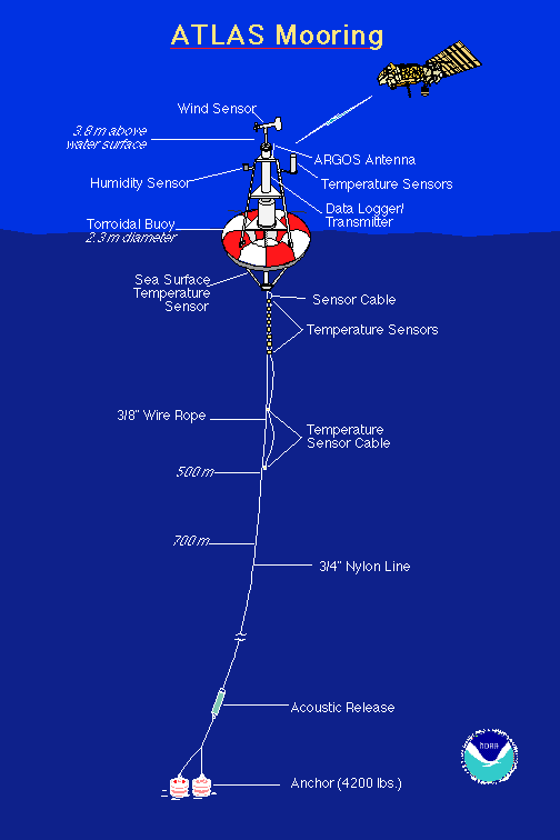
Dr. Paul Freitag, our Chief Scientist, provided some more information about the instruments on the buoys. First, the buoys are anchored to the ocean floor, which is still hard for me to believe. All of the buoys have sensors to measure temperature/relative humidity and an anemometer to measure wind speed along with wind direction. Some of the buoys have sensors measuring precipitation and solar radiation, but not all are equipped to with this expensive instrumentation. The buoy itself (the orange and white donut part) is composed of a foam core surrounded by fiberglass. Below this there is a rigid stainless steel bridle connected to a wire rope which is used for the first 500 meters of the mooring. On these 500 meters of wire rope there are nine subsurface temperature sensors (thermistors) followed by two pressure sensors accompanying two more thermistors. The pressure readings correspond well with measurements of ocean depth. Water temperatures are measured below the surface at 1 meter (m), 20 m, 40 m, 60 m, 80 m, 100 m, 120 m, 140 m, 180 m, 300 m, and 500 m. Below 500 m, eight-strand plaited nylon line is used down to the anchor, with some sites requiring nearly 3 miles of line (see the diagram at http://www.pmel.noaa.gov/images/atlas.gif). The amazing thing is that the subsurface temperature sensors transmit and receive data from the buoy with an inductive coupling technique, which means that they’re not wired directly to the main line, yet data are transmitted along the cable. The sensors simply clamp onto the wire rope that serves as one of the inductive elements. This makes it much easier to assemble and deploy the extremely long cable. One aspect of meteorology that I find fascinating is the instrumentation, so I spend much of my time looking at the wiring and instrument manufacturers and asking the scientists many questions about what and why and how…they haven’t seemed to mind so far.

Here is some more information about the people and activities on the ship. There are 31 people on board (seven of us are women) with bunk space available for only two more. There are 5 officers, 1 cadet, 10 scientists, and the remaining crew members who focus on making the ship and science work efficiently. We all greatly appreciate their help. Everyone eats breakfast from 7:00-8:00 AM (0700-0800), lunch from 11:00-12:00 (1100-1200), and dinner from 4:30-5:30 PM (1630-1730). There is a small store selling candy and snacks, soda, shirts and hats on the ship that is open each night from 1930-2000 hours. We can email from any computer on board (I’ve counted at least 14 computers) and all of our email messages are sent and received in a bundle two times a day around 0900 and 1600. There is a laundry room with three washers/dryers on the second deck forward on the starboard side of the ship. There are two lounges with library materials including books, magazines and board games. Movies are shown every night on two channels in the lounges at both 1730 and repeated at 2000. So, you can see that it’s easy to keep busy on the ship. Two extra treats on this cruise include guitar/music playing sessions for all those who brought their musical instruments on board, and French lessons every other night. Je m’appelle Diane. J

After seeing more flying fish today, I decided to do some research to find out exactly what these fish are all about. I learned that they’re often referred to as “bluebirds of the sea” and that they spread their pectoral fins, glide for a few seconds, and then splash back into the sea. When they swim, their long fins are folded against their body. Flight speeds of up to 35 miles per hour have been monitored and flights as long as 13 seconds covering up to 450 feet have been timed. Photography has proven that they are gliders and not true flyers (all information obtained in “Fishes of the Pacific Coast” by Gar Goodson, Stanford University Press, 1988). I’ll keep my eye on these beauties and attempt to take a photo so you can share this delight!

The first person to answer my question of the day posed in my August 17th log was Tom Taddeo (my incredibly smart uncle from Mechanicsburg, PA – thanks for responding!) who gave the correct answer regarding the definition of pitch, roll, and yaw of a ship. Yes, pitch is when the ship tips in a fore-and-aft direction (from front to back), roll means the ship tips from side to side due to the sea or swell, and yaw means that the ship swings involuntarily from side to side when advancing forward. I’d love to hear from more of you so I can acknowledge more people in my logs.

The afternoon was spent testing the computer and camera equipment that will enable us to connect with all of you via upcoming live webcasts. Fortunately, everything seems to be working very well! We even managed to get a wireless microphone to work. We’ll be testing again tomorrow and hope to have a general broadcast ready to go by the end of the week. Please contact Jennifer Hammond at jennifer.hammond@noaa.gov if you’d like to receive the live broadcast. We’ll be interviewing scientists and talking about life at sea!

We enjoyed a wonderful dinner again tonight and I’m nearly ready for bed. It was great to hear from Dana Tomlinson (our last Teacher at Sea!), Nancy from ASU, and as always, my husband, family members, and friends. I invite more of you to email with questions that you might have about the Ka’imimoana or what it’s like to live on a ship.

Until tomorrow when I discuss CTD’s (what are they, you ask?!? – more tomorrow!)…bon soir.

Question of the day: What is the difference between sea wave height and swell wave height?

More tomorrow…
Diane

P.S. I just walked outside and rain was falling on the buoy deck under bright pink clouds – beautiful!

Diane Stanitski: Day 7, August 17, 2002

NOAA Teacher at Sea

Diane Stanitski

Aboard NOAA Ship Ka’imimoana

August 16-30, 2002

Day 7: Saturday, August 17, 2002
Time: 0700 military time (based on a 24-hour time schedule)

Latitude: 21°14.715’North (N) Cruising just south of the Big Island of Hawaii visible this morning from the port (left) side of the ship when facing forward
Longitude: 157°57.378’West (W)

Weather Observations taken from the bow of the ship with Shippensburg University’s hand-held Kestrel 3000 instrument:

Air Temperature: 27°C (80.6°F)
Average Wind Speed: 6.3 knots (7.3 mph)
Cloud Cover: 8/10 with mostly altocumulus (middle level, puffy) and cirrocumulus (high level, puffy) clouds
Precipitation in previous 24 hours: 0 cm (0 inches)
Relative Humidity: 89%
Dew Point Temperature: 24.8°C (76.6°F) Relatively calm seas; beautiful sunrise; Porpoises spotted on the port (left) side of the ship

Quote written on the Plan of the Day (POD) posted outside the Main Mess (meal) area: “All excellent things are as difficult as they are rare.”
– Benedict Spinoza

After a restful night’s sleep on my upper bunk, I awoke ready for a new day! It struck me as I was lulling into a peaceful sleep that my mattress felt just like a waterbed. I thought that I was rolling around on a bowl of jello, a neat feeling which made me relax. I am fortunate that I haven’t experienced any seasickness yet. A few others haven’t been so lucky. Michelle, our fearless Medical Officer on board, has distributed medication for seasickness to those needing it. It is recommended that you breathe in fresh air and watch the horizon for a while if ever you feel queasy.

After touring the outer decks of the ship watching the sun rise above the morning clouds on the horizon, I stopped to speak with crew member Roger Stone who said that every day is slightly different because the sky is always changing. He recalled seeing a white rainbow at night under a full moon. I had never heard of this so I’m intrigued about what would cause such a remarkable feature.

Breakfast was interesting because I spoke with Rachel, a Cadet, and Steve, our Field Operations Officer (FOO) who received a degree in Meteorology at the University of Nebraska. We discussed Steve’s research and he said that I could come up to the bridge to take weather observations anytime. Yahoo! For some reason beyond me, weather obs are not everyone’s favorite activity of the day. Rachel taught me the difference between a pitching and rolling boat. She said that a pitching boat rocks front to back (up and down), while a rolling boat rocks side to side. She is currently taking a course requiring that she write a complete report of all of her activities while on board. I hope to learn many things from her, including celestial navigation — how to find your way using the stars. Can’t wait!

I learned from Steve that the reason it was a bit rocky in the ship last night was due to our travels through currents emerging from between the Hawaiian Islands. The currents disturbed the forward motion of the boat. Unknown to me, currents are named for the direction toward which they flow, unlike winds, which are named for the direction from which they blow. So, if ocean currents and winds are moving in the same direction, they have opposite directional names – very interesting!

I spent part of the day organizing my thoughts regarding my upcoming lesson plans. There are so many exciting ideas generated each day by the scientists as we talk. I will definitely interview the scientists on the ship about their current research as well as use the opportunity to describe the many mechanical and electronic sensors on board to everyone watching the webcasts. Please let me know what you would like to know more about and I’ll try to include it in a future webcast.

John pointed out flying fish on the port side of the boat today. They are quite small and it is believed that they fly to flee from whatever is gaining on them. They don’t have great ability to determine direction and they stay in the air for just a few seconds before splashing into the water again.

Our location and the weather observations at 1300 today were:
Latitude: 18°37.8’N
Longitude: 155°23.7’W
Visibility: 12 nautical miles (nm) which is about the greatest distance you can see due to the curvature of the earth
Wind direction: 060 (on a 0-360° scale) which means ENE
Wind speed: 19 kts
Sea wave height: 5-7′
Swell wave height: 6-8′
Sea Water Temperature: 26.6°C
Sea level pressure: 1015.0 mb
Dry bulb temperature: 26.2°C
Wet bulb temperature: 23.5°C

Sarah and Rachel gave me a tour of the ship’s bridge this afternoon. They discussed every aspect of their job and it was fascinating! They have radar on the ship to detect nearby ships and severe weather. On the front panel of the bridge there is an automatic pilot system for the ship. There are also throttles for the main engines, which allow us to travel at approximately 10-12 kts under ideal conditions. The bow thruster controls movement of the front of the ship from left to right. They described radio communication procedures with other ships, explained who has right of way when two ships are merging, and provided details about the nautical charts used during each journey. I made the mistake of calling nautical charts “maps” and was politely corrected. I will place this new term in my memory bank for future reference. I also was privy to a chart showing our upcoming transit line with waypoints approximately every 200 miles. The ship remains in a straight path until a certain point where a slight change of direction is made, otherwise, the bearing would constantly change as the ship’s path slowly curved.

After a workout and excellent meal of chicken stirfry, cauliflower, rice and pecan pie prepared by Helen and Doretha, I met with John who informed me that there would be a deployment of a test buoy tomorrow around 0900 and that he would like to videotape me on the buoy before it’s sent out to sea to explain the instrumentation on the mast. Earlier today I met with Dave and Paul, our Chief Scientists on board, and they explained the entire array of sensors and the purpose behind the buoy. It will be deployed and removed during this trip with data collected every few seconds and stored in a datalogger on the mast. During the return voyage of the KA to Honolulu in late September the buoy will be removed from the water and the data analyzed immediately following the trip. A compass comparison test and a buoy motion monitor test will be conducted. A specially engineered tube containing 3 different compasses and an accelerometer will enable the pitch, roll, and yaw of the buoy to be determined. As of yet, I believe that these movements on the buoy are unknown.

Today’s question: What is the pitch, roll, and yaw of a ship? Be the first to answer and I’ll acknowledge your response in my next log. I’ll write again tomorrow after a peaceful night under the millions of visible stars above.

Peace to all and to all a good night,
Diane