Geographic Area of Cruise: Gulf of Mexico/Atlantic Ocean
Date: Jul 28, 2023
Weather Data from the Bridge
Latitude: 25°49.441’N
Longitude: 79°59.970’W
Temperature: 30.5° Celcius
Wind Speed: 7 knots
The Oregon II at dock in Pascagoula, Mississippi.
Science and Technology Log
NOAA conducts the Shark/Snapper Longline Survey each year at the same time and place. It goes from July through September and surveys from Cape Hatteras, North Carolina, to West Palm Beach, FL, and the U.S. northern Gulf of Mexico from southwest Florida to Brownsville, TX. This is a longline survey and one mile of gear is baited and laid down for one hour.
When the line is reeled in, the science and fishing teams take them off the hooks and record data on the fish. The data gathered includes what species (kind of fish) are caught, if they are male or female, their age, weight and length. Additionally, the sharks will be tagged with a number and released.
The data collected will be used by NOAA to help manage the health of the fishery. It is one set of data that goes into deciding how many fish can be safely taken from the ocean each year. Without this information, fishermen might take too many fish to keep the population stable.
The Oregon II call sign flags, WTDO
NOAA Ship Oregon II is the ship that is used to conduct this survey each year. It takes a lot of people working together to accomplish this. The crew of the Oregon II is made up of several teams. Everyone has a job as a part of the team to make sure everything works as needed.
The NOAA Corps are the officers on the ship. They are responsible for the overall operation of the ship and are in charge of navigation, steering and everyone’s safety. They work in shifts from the “bridge.”
The engineering team makes sure that everything is working properly. This includes the engines, electrical systems, fresh water and the all-important air conditioning.
The deck crew includes the professional fisherman who do boat maintenance, prepare fishing gear as well as handle the big fish.
There are two stewards who prepare our meals and keep the dining area clean. They keep us well fed with several choices available at each meal three times a day.
The electronics department has just one person who is responsible to make sure all of the technology is working properly. That is a very big responsibility on this ship.
Finally, there is the science team. That is where I fit in. There are four NOAA scientists and six volunteers. I am one of the volunteers. The other volunteers are all university students.
There are 29 people on board and everyone works on shifts. The ship operates 24 hours a day so all jobs must be done around the clock. Most teams have two shifts that each last for… you guessed it… twelve hours.
Personal Log
These first few days have been spent getting acquainted with the layout of the ship, learning the routines of life on the ocean and the people on the ship. The most striking feature is that there seems to be an incredible amount of equipment packed into such a small space. Everything a crew of 29 could need for three weeks, emergency equipment and replacement parts. Yet, in any one place, there is adequate room to move and work. I have a “stateroom” that I share with one other member of the science team. Each of us have a “rack” to sleep in, lockers and drawers for personal belongings as well as a fold out desk to work at. We also have a sink and mirror. All this in a room that is about 7’X10’.
stateroom with two berths
Rarely are we both in there but there is adequate room when that happens. The “passageways” are narrow and it takes coordination to pass another crewmember. The “mess” seats twelve people, at most, so we have to eat meals in shifts.
NOAA Ship Oregon II‘s “mess” seats 12 people at most.
There are three bathrooms and two showers available for general use. Showers should be short to preserve water as well as to make it available for others to use. There are three different “gym” areas with equipment to work out in. My favorite is the flying bridge where you can look out over the ocean.
view from the flying bridge of NOAA Ship Oregon II
Safety is a priority on board the ship. We start by using basic safety procedures while moving around the ship. While underway, the pitch (front to back motion) and roll (side to side motion) of the ship never stops. This becomes more or less pronounced depending on the weather. So moving through the passageways and doorways and especially on the outside decks, one must be careful to use a hand to keep their balance. The stairwells are narrow and steep but negotiable. When using stairwells always have 3 points of contact, that means use two hands and then a foot is the third point of contact.
view down a stairwell on NOAA Ship Oregon II
Moving around comes more easily with time. No open toed shoes are to be worn except on the way to and from the shower. Safety equipment must be worn when working. We will be wearing hard hats, gloves, glasses and a work vest. The work vest looks a lot like a personal flotation device but flat. If you fall overboard it will automatically inflate. There is a lot of equipment and devices all over the ship for use in emergency situations.
firefighting equipment in case of emergencies
Fire extinguishers, AEDs, masks for smoke, and, of course, life rafts. We have to do drills to make sure that we know what to do in emergencies.
our firefighting team
That’s me in a “Gumby” suit for survival in case we have to abandon ship.
Did You Know?
Did you know that not all sharks reproduce the same way? Be sure to check future blogs to find out how.
Animals Seen Today:
brown booby
dolphin
and also: masked booby, swallow, flying fish, barracuda.
Mission: Hydrographic Survey of the Pribilof Islands
Geographic Area of Cruise: Pribilof Islands, Alaska
Date: July 24, 2023
Weather Data
Location: 56°36.8259’N,169°32.2224’W
Outside temperature: 11°C
Water temperature: 10°C
True Winds: 16kn, 185.4°
Skies: Foggy with Drizzy Rain
Visibility: 5nmSea
Wave: 1-2 ft
Swell Wave: 1 ft
Science and Technology Log
We are currently at anchor off the north shore of Saint George Island and the survey launches are going out daily to survey a portion of the surrounding waters. I have been on the survey launches twice, each time surveying a different area.
Survey Launch July 22, 2023
The Pribilof Islands are the breeding grounds for more than two thirds of the world’s fur seal population and their numbers peak in July. Our surveying operations do their best not to disturb the Fur Seals. I was on a launch that was assigned the harbor. However, upon entering, we saw a colony of Fur Seals and had to turn back around. We then went onto survey another area in open water. Later that morning, the winds increased and all survey launches returned to the ship out of caution for the weather.
Entering the harbor at Saint George
Fur Seals in the Saint George harbor
Survey Launch July 23, 2023
We went out to survey an area closer to shore and were out all day – a good weather day. We surveyed using set lines; this is where survey lines are parallel and evenly spaced apart. During post survey data processing, these lines of coverage will be used to update soundings on the chart. Set lines are used in areas of shallow water where there is not much bathymetric data, such as the Pribilof Islands. This process allows the survey team to complete a larger survey area in less time.
Our surveying boundary close to shore is defined by the navigational area limit line (NALL), which is the distance from shore that vessels can reasonably navigate. The other boundaries are mapped out by the survey team ensuring coverage of the entire area. During surveying in addition to depth data, any information about features that can impact navigation need to be noted. This can include an outcrop of rocks, shipwrecks or a kelp forest. We did see a kelp forest close to the shoreline during this survey, and indicated that in our data. Kelp forests can increase or decrease in size depending on the year and water temperature, but generally stay in the same place.
The swath is the width of the survey lines. During surveying the swath gets larger as the depth increases. In this survey, as you move away from shore the depth becomes deeper, so the width of the swath increases as well. This is due to the fact that the MBES angle is fixed and the depth is related to the swath by the tangent function.
Screen showing the set line spacing and data taken near the shore.
Close to the shoreline of Saint George. The color change of the water indicates a kelp forest. Thousands of sea birds are on the cliffs.
How the width of the swath can be calculated.
TAS Elli Simonen on a survey launch close to shore of Saint George, one of the Pribilof Islands
At the Helm of the Survey Launches
Coxswains are responsible for steering and navigating the survey launches. They use a variety of instruments and sensors to maintain safety and guide the survey launches over the planned survey lines. The heading is the direction the bow of the ship is pointing, expressed as a degree measurement from 0° to 360°. We were mainly surveying lines that were running north-south and the heading measurement was 0° when we went north and 180° south.
Heading indicator showing the direction of the survey launch and allows for autopilot.
Magnetic Compass showing heading on the survey launches.
Screen for coxswains on survey launches showing depth, the water column and survey lines.
TAS Elli Simonen attempting to steer the Survey Launch with NOAA Corps member ENS Ashley Howell. It is much harder than it looks!
Personal Log
Day to Day
Most of my days have been spent on the ship or lately, on survey launches. If I’m on the ship, I usually spend most of the day in the survey room with the survey technicians. Breakfast is served from 7-8 am, lunch is from 11-12 pm and dinner is 5-6 pm. Sometimes a movie is shown in the lounge in the evenings, but the other day we streamed the Women’s World Cup to see the USA win their opening game!
Some of the common areas of the ship
The survey room where all the survey technicians have their work stations.
The galley with lunch available
The mess, where we all eat meals.
Washers, dryers and soap are provided for everyone’s use.
The Pribilof Islands are also home to millions of sea birds. Birdwatchers can see red-faced cormorants, red-legged kittiwakes, northern fulmars, thick-billed murres, and puffins. These species nest in the island’s cliffs and tundra. (https://www.adfg.alaska.gov/index.cfm?adfg=viewinglocations.pribilofislands)
Mission: Pacific hake (Merluccius productus) Survey (Leg 3 of 5) Geographic Area of Cruise: Pacific Ocean off the Northern California Coast working north back toward coastal waters of Oregon. Date: July 24, 2023
Weather Data from the Bridge
Sunrise: 05:46 | Sunset: 20:51 Current Time: 8:30am Pacific Standard Time (0830) Lat 42 06.5819 N, Lon 124 58.5931 W Visibility: less than 1 nautical mile Sky condition: overcast, Present weather: fog Wind speed: 10 knots Wind direction: 115° (east southeast ESE) Barometer: 1017.5 mbar (millibars), approx. 30 hg (inches of mercury) Sea Wave height 1 ft | Swell 260°, 3-4 feet in height Sea temp 15.2°C (59.36°F) | Air Temp 57.38°F Course Over Ground (COG): 359.2° Speed Over Ground (SOG): 11.3 knots (13 mph)
Science and Technology Log
Let’s break down the weather and navigation data that you may not be familiar with:
What is a nautical mile as compared to a “regular” mile? Nautical miles are used to measure the distance traveled through the water. A nautical mile is slightly longer than a mile on land, equaling 1.1508 land-measured (or statute) miles. A nautical mile equals exactly 1,852 meters or approximately 6076 feet. The nautical mile is based on the Earth’s longitude and latitude coordinates, with one nautical mile equaling one minute of latitude. (Source: NOAA)
What are knots? One knot equals one nautical mile per hour. A knot is a unit of speed that ties directly into the global latitude and longitude coordinate system. Aviators and sailors find knots are easier to navigate due to their relationship with degrees of latitude. Land-based miles per hour do not share a relationship with latitude and longitude. A knot is equal to about 1.15 land-based miles. Knots are tied (pun intended) to nautical miles traveled. The origin of measurement comes from a piece of wood tied to the ship with a piece of knotted rope, with the crew members then counting the number of knots between the ship and the piece of wood after a certain amount of time.
Measuring ship speed with a knotted rope. (GIF credit: NOAA)
What is a millibar? A unit of atmospheric pressure equal to ¹/₁₀₀₀ bar or 1000 dynes per square centimeter. Wait, what’s a dyne? This is a physics concept. A dyne is a force that acts for one second and produces a change in velocity of one centimeter per second in a mass of one gram. When I blow on the surface of my peppermint tea to cool it off I am exerting the force of my breath and changing the velocity of the tea’s surface.
The air around you has weight and exerts pressure on everything it touches. Press lightly with your fingers on the back of your other hand to feel more noticeable pressure. Gravity is pulling on the air as well, just like it is keeping you anchored to Earth.
Atmospheric pressure is an indicator of weather. It’s obviously a windy day down in the land of peppermint tea when (my) wind is blowing. When a low-pressure system moves into an area, it usually leads to cloudiness, wind, and precipitation. High-pressure systems usually lead to fair, calm weather.
Barometers gauge pressure. Hg represents inches of mercury in a classic barometer. One inch of mercury is the pressure exerted by a 1-inch high column of mercury at 0°C (32°F ) Millibars is a metric measurement while inches of mercury (hg) is the English unit of measurement.
Atmospheric pressure at various altitudes. (Image credit: Britannica)
What is a heading? The direction in which a vessel’s bow points at any given time. It is the angle between North and the bow of the boat.
What is Course Over Ground? Course Over Ground is the actual direction of progress of a vessel, between two points, concerning the earth’s surface. The vessel’s “heading” may differ from the Course Over Ground (COG) due to the effects of wind, tide, and currents.
A ship’s headings v. its course over ground. (Image credit: FleetMon)
How do you read wind direction in degrees?
How to read wind direction (Image credit: Windy.App)
Career feature
NOAA works with a multitude of contractors that are associated with other entities such as Oregon State University (OSU) and the Pacific States Marine Fisheries Commission (PSMFC). The science crew on leg 3 includes three individuals associated with OSU concerned with marine mammals and birds (Nick Metheny, Chris Hoefer, and graduate student Jake Marshall), one fisheries technician (Liz Ortiz, with PSMFC), two independent contractors (Ethan Beyer, Wet Lab Lead; Samantha Engster, environmental DNA sampling), and two NOAA employed scientists: Steve de Blois (Chief Scientist, Acoustics), and Julia Clemons (Acoustics).
The lesson here is that you can be contributing to NOAA’s Fishery work but not necessarily receiving your paycheck from them, as is the case with contractors. NOAA also welcomes ocean enthusiast volunteers, which is true both of myself and second-year graduate student Jake. Jake’s focus is to examine how proposed wind farms off the Oregon Coast, along with rising sea temperatures, may impact the migratory patterns of hake. His undergraduate degree is in applied math.
Career trajectories are well represented within the science crew. Liz represents an entry-level position, while Steve represents a senior scientist with many surveys under his belt.
Tour of Hatfield Marine Science Center Campus
On Friday, July 21st I had the opportunity for a brief tour of buildings on the Hatfield Marine Science Center (HMSC) campus. The general public is limited to the Visitor Center where a Giant Pacific Octopus is on display along with numerous educational exhibits.
My guide was Alicia Billings, a Fishery Biologist who specializes in engineering (such as underwater cameras) and database management for NOAA Fisheries. She is currently working on a Master’s in Data Analytics at Oregon State University. Truly a renaissance woman, who crafts all sorts of contraptions for expeditions, she also serves as a point of contact for the TAS program.
I met her at a cafe just inside the new Marine Studies Building. It’s the newest structure on campus and allegedly designed to withstand a magnitude 9.0+ earthquake and subsequent tsunami. It’s touted as a vertical evacuation structure and contains a community cache with emergency supplies. An imposing stairway leads to the upper floors and is lined with an art installation that imitates portholes on a ship. Alicia pointed out an Innovation Lab on the main floor which appeared to have many interesting mechanical devices to experiment with. A bulletin board at the entrance announced summer and fall classes: Food From the Sea, Phycology (micro & macroalgal biology), Aquaculture Lab.
The next stop was the OSU Guin Library, which I couldn’t resist peeking into. An impressive whale skeleton hangs near the entrance. Marilyn Potts Guin was the first librarian for HMSC. Under her “exuberant guidance,” she convinced the HMSC director at the time that the site needed a real library. The education building had room so Guin started filling it.
HMSC is an academic research field station that evolved into a multiagency research campus. The Environmental Protection Agency (EPA), Oregon Fish and Wildlife Department along with its federal counterpart are all partners on campus. When the EPA provided funding for a new library building, Guin provided guidance on the design. Sadly, she passed away from breast cancer at age 45 while construction was underway.
Guin’s exuberance echoed long after her departure when a 2014 remodel was assisted by the sale of her house, which she had left to the university. The library continues to adapt to the ever-changing information landscape but maintains its core focus on materials related to marine fisheries and mammals, and information specific to the Northeast Pacific Ocean. A ‘new books’ display included: Tales of the Sea Cloud, Coastal and Deep Ocean Pollution, Seaweed Biotechnology, and (appropriate to the survey) Advances in Fish Processing Technology.
A myriad of bookish treasures presented themselves: color plates of tropical coral fish from the Indo-Pacific, a glass-enclosed case of old tomes like Eniwetok Marine Biological Laboratory Contributions 1955-1974. Then, lo and behold, a modest collection of children’s books! All non-fiction science as far as I could tell. Rounded shelf marker stickers announced: Oceanography! Zoology! Sharks! On the way out I noticed a whiteboard asking, “What Are You Excited About for the Summer?” See the gallery images below for how I answered.
Just when I thought it couldn’t get any better, there was a shelving cart labeled “Free Books.” I’m not sure that my elementary students will be as excited about a withdrawn copy of ‘Proceedings of the West Coast Squid Symposium (February 1983)’ as I was, but perhaps I can use it to introduce them to the word “symposium” and to use as scientific realia during a lesson on squids.
Following the library tour, we walked over to NOAA’s Barry Fisher Building #955. In one room, otoliths (ear bones from which a fish’s age is determined) from previous legs of the hake survey were being processed. Other items of note in the building included a -80°C freezer for fishy samples awaiting transport. For example, gonads are processed in Seattle, not in Newport. Another freezer was filled with labeled crates: Big Skates & Black Skates, Deepsea Skates & Starry Skates.
Offices belonging to many of the science crew joining me on leg 3 were upstairs. This is where I first met Liz Ortiz, meticulously counting otoliths. One year is equivalent to an opaque ring (feeding activity) and a translucent one (lean times in the mess hall). The feeding cycle has to do with a pattern of upwelling, which produces elevated nutrients, and downwelling: “Hey! Who took away the salad bar?” Liz was looking at walleye pollock at the time and had recently counted 88 rings. The oldest fish on record are upwards of 200 years old. Hake are shorter lived with 15-20 years being the top end of the grumpiest specimens.
Alicia also showed me a room that houses a host of technology components. One of the items was a broken underwater stereo camera she attempted to fix. Unfortunately, it will not be ready for leg 3.
The final part of the tour was a preview of the NOAA Ship Bell M. Shimada. In the wet lab, Alicia pointed out her contributions. Alicia’s knowledge of electrical engineering is self-taught (most NOAA tech is DIY). She used Python to create a software called CLAMS–Catch Logger for Acoustic Monitoring Survey. Data from the wet lab is added to the software and is backed up to a database (the mother CLAM, if you will) that lives in the acoustics lab. Alicia wired something together called the ‘electronic back deck’ where the fish data initially goes prior to being backed up to the Mother CLAM. There are four separate networks on the ship, but all data is shared among them. The old system used isolated spreadsheets… welcome to the 21st century!
Technology Remember the ship tracker technology from blog post 1? Here’s a look at the AIS equipment on the bridge. Additionally, there are two radar screens in the suite of instrument panels available to navigators. One uses an X band for short range and the other an S band for long range. A gyroscope is used for maintaining orientation, and an analog compass serves as a last resort if redundancies in backup power fail more contemporary instruments. Two pedestals on the exterior bridge deck contain the gyro bearings.
AIS on Bell M. Shimada allows you to track us.
A view of the “driver’s seat.” A few of many instrument panels on the bridge.
Taxonomy of Sights Day 1. An albatross (observed by OSU marine mammal observer), a pod of humpback whales feeding last night near sunset (observed by fisheries technician with PSMFC).
Fog has impeded observations on day 2 of our leg.
Day 2. Several whale “blows” during our marine mammal watch prior to trawling. If mammals are within 500 meters of the ship we wait until they move off before dropping the net.
You Might Be Wondering… Where exactly is this survey taking place? We steamed south from Newport to a transect off the California coast– #35 in the image below. We’ll follow those lines similar to mowing the lawn, a back and forth to case the continental shelf for hake. The goal is to complete all transects through 57. A transect is simply a straight line along which observations, measurements, and samples are taken. The first hake survey on the West Coast occurred in 1977. In 1992 a partnership with Canada was formed, and in 2003 the FEAT Team started conducting biennial surveys.
Like any industry there are acronyms that can get confusing.
The FRAM division is Fishery Resource Analysis and Monitoring Division.
The FEAT Team is Fisheries Engineering and Acoustic Technologies Team (not to be confused with Fishery Ecosystem Analysis Tool).
Map of planned transects for the hake and ecosystem survey
Floating Facts
The Bell M. Shimadaflies the NOAA Service Flag along with the flag of the United States (National Ensign) and the POW/MIA flag of the National League of Families of American Prisoners and Missing in Southeast Asia. In port she also flew a Union Jack pennant from the bow mast.
Flags aboard NOAA Ship Bell M. Shimada
Government Nesting Dolls: The Department of Commerce is one of 15 departments in the federal government. View an organization chart here. See where NOAA falls under the 13 arms of the Department of Commerce here. NOAA has multiple branches as well. Our survey is made possible by the National Marine Fisheries Service (NMFS) and Office of Marine and Aviation Operations (OMAO), including NOAA Corps, working together. Notice the nautical theme on the Department of Commerce emblem in the image below.
Personal Log
The Road from Portland to Newport
I woke up with the birds on Friday, July 21st to travel via personal vehicle to Newport, Oregon from my home in Portland. Hwy 18 crosses the Willamette Valley in a south-westerly manner when originating from the north. The view out the window is something like an advertisement for “Made in Oregon.” A cornucopia of agricultural goods beckon: orchards of walnuts, hazelnuts, apples, pears. A combine parked under a tree made me think of my Dad, retired from the agricultural community, but driving a combine “for fun” for a farmer friend. Just the day before he had driven the behemoth machine onto the Buena Vista Ferry in Marion County crossing the Willamette River—which dumps into the Columbia, which runs into the Pacific, which is where I was heading.
Many years back, during the Ice Age floods, a rock came to rest on an improbably flat spot in what is now Yamhill County. An unassuming brown sign marks the road you turn down to view it. Unremarkable looking except for its size and location. This glacial erratic serves as an example of the power contained in collective molecules of H2O. The Valley (as locals call it) is fertile in part due to the rich silts washed here by ancient floodwaters (our apologies to Eastern Washington—here’s a glass of merlot from Siltstone Winery for your troubles). Farmer John’s Market boasts peaches, strawberries, apricots, raspberries, smoothies, shortcakes, and milkshakes—the latter of which do not grow on bushes or trees. After passing the sign for Wetzel Winery you get a few more grass seed fields, some fallow, some with boxes for bee colonies. The landscape then begins to transition into the foothills of the coast range. Queen Anne’s lace and Himalayan blackberry fill in the gaps between the field and road.
Yamhill is traded for Polk and the fir trees start to get serious, accompanied by ocean spray (the bush also called ironwood or Holodiscus discolor), vine maple, and rhododendron. The flower clusters of ocean spray are reminiscent of lilac, except these are a peachy off-white. At a distance, the multi-toned green of trees on distant hillsides illustrates staggered replanting after a patchwork of clearcut harvests. As Hwy 22 East merges with 18, I think about childhood trips to the beach. Our family most frequently traveled 22 to 18 to Lincoln City which sits 25 miles north of Newport. We made a pilgrimage about once a year, sometimes in the off-season to avoid crowds. A series of billboards still promote businesses that we patronized in the 1980s and 90s. Undersea Gardens—which is no more—was of particular interest to me. I was captivated by “Armstrong,” the Giant Pacific octopus who entertained visitors by interacting with a diver in his tank. The name made an impression on me, signifying that this was a creature to be respected. Our family stayed at The Inn at Otter Crest, Pelican Shores, and other establishments whose names are lost to me. Mo’s Chowder was a frequent stop, where I delighted in the chewy clam pieces floating in cream. I admit that as an adult I find the chowder a bit too rich, a bit too heavy in butter. Or maybe it’s just me that’s heavy!
Hwy 22 diverts from 18 just before Spirit Mountain Casino—operated by The Confederated Tribes of Grand Ronde. CTGR puts on an excellent educator summit that happens annually. Oregon educators are compelled by the legislature to fulfill SB13, which promotes “Tribal History is Shared History.” It strives to share the stories of Oregon’s First Peoples with young Oregonians. Indigenous communities persist in our state and there are always a few students in my elementary school who declare tribal affiliations.
Among the other billboards are Chinook Winds, The Oregon Coast Aquarium (which broke ground in 1990), and one recommending, “Explore Lincoln City” with a sea lion balancing a glass float on his nose. When I was a child, the billboards were key in the escalating excitement of reaching the beach. The first glimpse of the Pacific was always a special moment in the car, often accompanied by celebratory mouth trumpets and squeals. The H.B. Van Douzer corridor and its whopping 760-foot Murray Hill summit is the last section of road to traverse before hitting Hwy 101. The coast range is fraught with landslides in winter and there are multiple patches of rough road. Cue the chorus of voices in a car full of children, “Ruh-ro!”
The sign for Tillamook County flashes by and the turquoise sky becomes populated with purple-hued clouds that have a misty edge, a tell-tale sign of marine influence. Lincoln County comes next and the sun is left behind at Slick Rock Creek. Speaking of rocks, the local news was all aflutter this past week with the tale of a cougar trapped by tides on Haystack Rock at Cannon Beach. Another recent story comes from an Australian sailor and his dog (!) rescued by a Mexican tuna boat after three months adrift at sea.
You know you’re really close when you see the white and blue sign proclaiming, “Entering a Tsunami Hazard Zone.” I will do my best NOT to think about the statistical probability of a Cascadia Earthquake during the next two weeks. D Sands was often the first stop during family trips of yesteryear. It’s adjacent to D River, claiming to be the world’s shortest. Depoe Bay is the next town south of Lincoln City. Between Newport and this charming and often congested whale-watching spot is Beverly Beach State Park. During a geology project in college, I was infamously caught on camera here discussing “sands of grain.”
I was equally tongue-tied when I entered the gated MOC-P facility where the Bell M. Shimada lives when in port. “I’m with the Teacher at She program!” To which I sheepishly told the security guard, “Um, yes, I’m a she, but I’m here to go to sea.” I am now, in fact, at sea. Over the course of the following blog posts, I’ll share more about what life at sea is like.
Librarian at Sea
“Now small fowls flew screaming over the yet yawning gulf; a sullen white surf beat against its steep sides; then all collapsed, and the great shroud of the sea rolled on as it rolled five thousand years ago.― Herman Melville, Moby-Dick or, the Whale
Day 1. 7:30pm As my stomach screamed over the yawning gulf it couldn’t quite reconcile what was happening and promptly evacuated its contents on the main deck about an hour after dinner. At which point I upgraded to scopolamine (prescribed slow-release patch behind the ear) over a cocktail of dramamine and meclizine. The lesson here: sometimes you can only learn through the school of hard knocks.
Hook, Line, and Thinker What’s a whale’s favorite phrase? Where there’s a whale, there’s a way.
Innovating on the spot is a hallmark of research excursions. Chief Scientist, Steve de Blois, shared an anecdote about a time in 2005 when an instrument pod fell off the hull-mounted centerboard of an older vessel, making acoustic data impossible to gather. Where there’s a whale there’s a way, and the team sprung into action creating a new apparatus from parts available, though the frame for the solitary transducer was made off-site. In contrast, the Bell M. Shimada has fancy watertight doors that open up to its instrument pod, which can be raised or lowered as needed. This allows easy access for cleaning and tinkering as needed. This improvement in ship design eliminates the need for NOAA Divers in this case, who previously could only work on instrument pods from beneath the surface.
watertight doors to instrument pod
A Bobbing Bibliography
The ship’s lounge is where movie nights occur, where the ship store is located (clothing, stickers, and swag), and where you can grab a game, magazine, or book to pass the time.
Mission: Hydrographic Survey of the Pribilof Islands
Geographic Area of Cruise: Pribilof Islands, Alaska
Date: July 19, 2023 Weather DataLocation: 57°11.82’N, 170°27.52’W
Outside temperature: 13°C
Water temperature: 11°C
True Winds: Direction 242.4°, 13.7 kn
Skies: Overcast and Foggy
Visibility: 2 nm
Sea Wave: 2 ft
Swell Wave: Direction 240°, 4 feet height
Science and Technology Log
We have arrived at the Pribilof Islands after being en route from Kodiak for 3 days. We are currently surveying.
Geology of the Aleutian Islands
The Aleutian islands stretch from North America into the Pacific and contain 40 active volcanoes. This string of islands is where the Pacific Plate sinks under the North American Plate causing some of the largest earthquakes of the last 100 years. NOAA Ship Fairweather often receives alerts about Volcanic Eruptions including information about ash in the water when sailing around the Aleutian Islands.
On July 15th at 10:48 pm, at a depth of 13 miles, a 7.2 magnitude earthquake struck just south of the Aleutian Peninsula, triggering a tsunami watch and then warning. NOAA Ship Fairweather was in the direct vicinity, but did not feel a noticeable shake. Luckily the tsunami watch and warning were canceled shortly after, and the earthquake did not cause significant wave heights. Investigation of observed water levels at the Sand Point, AK tide station showed some variability when compared to the tide predictions.
Observed water levels the night of the earthquake and tsunami warning.
Video showing the Bow of NOAA Ship Fairweather sailing just south of the Aleutian Peninsula
Engineering On Board
The engineering team on NOAA Ship Fairweather consists of 8 engineers. They are in charge of maintaining the engine, all power and water on board. They typically work in 4-8 hour shifts, 24-hours per day, to ensure everything is running smoothly. The ship’s two main engines power shafts that are connected to controllable pitch propellers. To move a boat forward, both the pitch of the propellers and Revolutions Per Minute (RPM) are adjusted. Pitch is the angle of the propeller blades and RPM is how many times the propellers rotate per minute.
The engine room also supplies clean potable water for the entire ship. Through the process of reverse osmosis, sea water is compressed in cylinders and salt is filtered out. The water then goes through multi-stage and UV filters to ensure safe sanitation.
Power is supplied by three generators and one emergency generator. These generators power all electric, navigational and satellite receiver systems.
One of the Engines
Reverse Osmosis Unit, used to make potable water from seawater
TAS Elli Simonen in the Engine Room
Surveying with NOAA Ship Fairweather
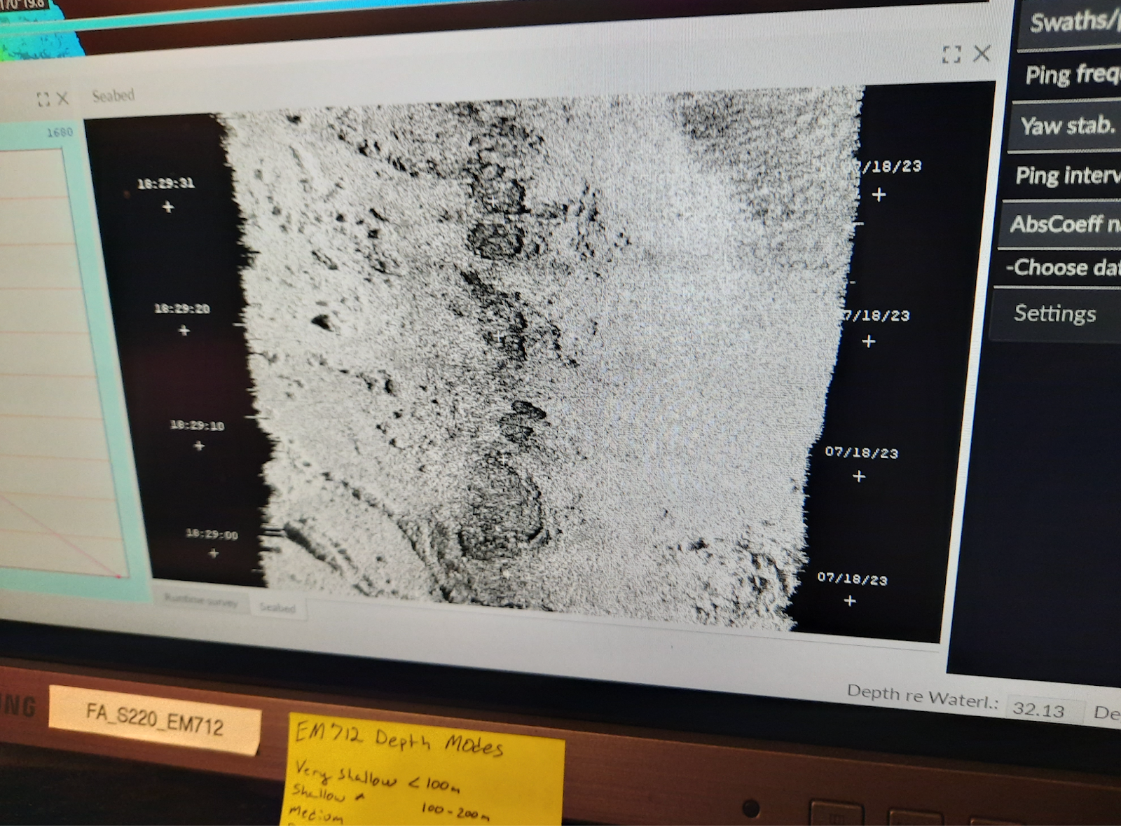
We have been surveying at the Pribilof Islands for the last 1-2 days. We are surveying using the ship and the team is on a 24 hour rotation. The survey area is divided up into polygons, or smaller areas, of which we completely cover one at a time. The ship drives back and forth in overlapping lines over the designated polygon. In addition to the MBES data, we gather both backscatter and water column data as well.
Backscatter is a visual representation of the surface of the seafloor. Backscatter provides information about the intensity of the returned echos, from which the “hardness” of the bottom as well as other characteristics can be used to differentiate between different types of seafloor composition. Darker colors represent harder surfaces such as rocks and hard coral and lighter colors represent softer surfaces such as sand and mud. This information is important for ships to know for anchoring purposes, as well as benthic habitat characteristics.
The water column data shows us what is under the ship throughout the water column– from the surface of the water to the seafloor. It detects bubbles, objects protruding from the seafloor, fish, or even a whale or a seal.
Water column Data
Backscatter showing a representation of the seafloor
TAS Elli Simonen with Survey Technician Finnegan Sougioultzoglou
Personal Log
Safety and Routine Checks
Before coming on board, I did not realize all the preemptive safety measures that need to be taken to ensure the health and safety of everyone on board. The staff and crew need to be self-sustaining on all accounts; another person, equipment or supplies cannot be added mid-sail. There are cooks onboard as well as medical staff. There are 3 drills and situations that the entire crew participates in, including myself – Fire, Mariner Overboard and Abandon Ship. You need to know the pattern of alarms for each, as well as where to go and what to do. For example, for Mariner Overboard I go to the fantail of the ship, with others, and point at the person in the water until a small boat can go out and rescue them. Each one of these drills is practiced periodically. Additionally there are two sets of rounds every hour, 24 hours a day – a deck round and engine rounds. Deck rounds check all public spaces for anything abnormal. Engine rounds check the engine room to see if everything is working properly. Every week, refrigerators are checked for correct temperatures and water is checked for potential bacteria.
New Terms/Phrases
I’ve learned several acronyms and initials since I have been on board NOAA Ship Fairweather. Sometimes I feel two consecutive sentences cannot be said without some type of abbreviation. These are some that have become part of my vocabulary:
Mission: Pacific hake (Merluccius productus) Survey (Leg 3 of 4) Geographic Area of Cruise: Pacific Ocean off the coast of Newport, Oregon Date: July 19, 2023 (pre-cruise)
Weather Data from Newport, Oregon NOAA Weather Service forecast for Wednesday, July 19th as of 7/17/23 6:35pm: Mostly sunny, then sunny and breezy, with a high of 61 degrees. Wednesday night’s low around 55 degrees.
“Weather” is what it’s doing today. “Climate” is what it did today in 1942. Climate equates to the prevailing weather trends for a particular region. Having been born and raised in Oregon I know that you always dress in layers when going to the Oregon Coast. I know that sunburn is possible in March (anytime really) and balmy 60-degree weather is possible in February. Historically, the average temperature for the month of July in Lincoln County has remained between 60 and 63 degrees with a slight trend upward. I imagine it is a bit chillier out on the Pacific. I have packed accordingly!
A week from departure (July 16th) I was looking south from the cliffs on Cape Lookout near Tillamook, Oregon. The breeze was visible in shimmering white flashes across the surface of the ocean even as the tidal swells plowed steadily into shore beneath the gusts. The infamous summer fog shrouded much of the cape’s seaward view due to temperature and pressure differences between the coast and inland.
As air heats up it ascends (rises), leading to low pressure at the earth’s surface. As air cools down it descends (sinks), leading to high pressure at the surface. Hot summer air rises inland and creates low pressure. Since the temperature of the ocean is much colder, high atmospheric pressure is formed. Higher-pressure air tends to move into lower-pressure regions, so the moist marine layer (caused by evaporation) gets pulled off the top layer of the water and moves inland. All that moisture creates low-flying clouds, known as “fog” when it touches the ground. Marine fog moves eastward (inland) and usually clings to the shoreline. Sometimes it moves further depending on the topography of the coast range. Summer winds on the Oregon Coast are caused by temperature-driven atmospheric pressure disturbances where the two pressure systems collide.
Listening to the weather forecast was something of a ritual in my childhood home. Mom would tune in to WKL96 at 162.475 and we’d dutifully hush up when the familiar “ding!” occurred to signal the top of the broadcast. To this day she still writes down the short-term forecast and puts it on the fridge. (Mom is an old-fashioned gal and doesn’t use the internet.) Find your local station here.
I got to tour my local National Weather Service office –home of the “ding!”– in Portland, Oregon during a DataStreme Climate class I took in 2016. Sponsored by the American Meteorological Society, I also took their DataStreme Oceans course. I highly recommend these classes to educators.
I’m a bit of a NOAA snob when it comes to the forecast. My old Subaru had a channel entirely devoted to NOAA Weather Radio. My new (used) one doesn’t, and I miss it! Friends and family look at a variety of weather apps, but I will always check their predictions against what NOAA says. When you visit National Park Visitor Centers around the country it’s usually the short-term NOAA forecast that is posted on visitor information boards. It is possible to access NOAA Weather from your phone. Go to the following website to learn how to add a bookmark to your phone’s home screen.
Librarian at Sea
“Traditionally, a few people from Raftworld would decide to stay on the island; and a few from the Islands would elect to join Raftworld. These were volunteers, and they were celebrated for their choosing, for some people were simply happier living on land, and others happier at sea.” ~H. M. Bouwman, A Crack in the Sea (G.P. Putnam, 2017)
A Crack in the Sea is a middle-grade novel that blends fantasy with historical fiction, including characters who flee a slave ship, and those fleeing post-war Vietnam. One character also has a special skill: talking to fish. My special skill is talking to children about books…but I do much more than that.
Introduction & Background
I have reported to 551.46 many times over my 18 years as a school librarian, but this will be my first reporting to its physical manifestation. Despite growing up near the coast I have never been out on the open ocean in a boat. I have visited the nonfiction shelves (organized by Melvil Dewey) countless times. You’ll find oceanography topics at 551.46. You’ll find my school, Peninsula Elementary, on an earthen finger of Portland, Oregon bordered by the Willamette River to the west and the mighty Columbia River to the north. Peninsula has been my anchor as an educator for the past 12 years. I call myself a “teacher librarian” in order to emphasize that my priority is to design and deliver lessons to students on top of managing a small library. My profession has state and national standards that cover information literacy, reading engagement, and social responsibility. One of the things I love most about being a school librarian is the academic freedom that I have. I can teach my standards by using the story of the haenyo mermaids of Korea, by analyzing infographics of the water cycle, and by playing truth or lie with shark facts. Cross-curricular approaches to learning are what get me excited about teaching. Science in particular is a subject I have long gravitated towards.
My career in a, er, clamshell: As an undergraduate with a BA in Comparative Literature I said, what next? I promptly got a seasonal job as a Ranger Aide for Silver Falls State Park. What next? I applied to permanent ranger jobs…and my old school district (where I graduated high school) was looking for a school librarian. My alma mater hired me with zero experience on a restricted transitional license–which means I promised to go back to school and get certified. So, I got my teaching license, then a Master’s in Library Science–two distinct programs. While in graduate school I began branding myself as a “Ranger Librarian.” While working for the same junior high I once attended, I had the odd experience of working with colleagues who were formerly my teachers. A beloved high school social studies teacher still worked next door on our shared campus. He encouraged me to seek out opportunities for educators that provided residencies, travel opportunities, and hands-on learning. So, when I saw a brochure in the staff lounge for an Outward Bound course designed just for teachers I applied. What next? I applied for a Cultural Resources Internship at Grand Teton National Park where, among other things, I created an information package for prospective researchers to help them navigate the application process and eliminate research redundancy. I learned, for example, there is such a thing as collecting too many voles. I applied for a “Teacher Ranger Teacher” position at Grand Canyon National Park. I applied to be a seasonal ranger again, this time in the Columbia River Gorge. I applied for a Comparative Mountain Geography Institute with the Center for Geography Education in Oregon. I did all those things in the margins of my life as a teacher librarian. What next? I applied to be a NOAA Teacher at Sea!
As the others in NOAA TAS Class of 2022 and 2023 will confirm, I then played the pandemic waiting game while the world figured out how to function with COVID. TAS candidates have to pass a medical clearance within a year of sailing so I even gave blood not once, but twice, while time and tide marched on. I have yet to sweat, and yet to cry, but the salt swims at the ready.
Getting a sunburn in March 2023 near Manzanita, Oregon with my husband. You can see a fishing boat in the distance.
Science, Technology & Career Log You can track the location of NOAA Ship Bell M. Shimada as well as other vessels here. Alternatively, you can try this tracker. Marine traffic includes all ships at sea such as tankers, military vessels, passenger ships, and fishing boats. An automatic identification system, or AIS technology, is used to follow traffic locations. The International Maritime Organization (a branch of the United Nations) launched the development of AIS as a collision avoidance tool for large vessels at sea that were not within range of tracking systems based on shore.
The IMO decided that all vessels over 300 gross tonnages on international voyages must have AIS aboard. A gross tonnage is calculated by measuring a ship’s volume. AIS allows ships to “see” each other and improves situational awareness before visual contact is possible. AIS is considered by some to be the most significant improvement to navigational safety since the development of radar. However, AIS is considered an enhancement and not a replacement for radar and other traffic services. Using a broadcast transponder system, AIS operates in the VHF (very high frequency) radio waves mobile maritime band. A complete system includes a transmitter and a receiver with data displayed on a screen (revealing the bearing and distance of nearby vessels). Originally, AIS made broadcasts from ships to land and had a capacity of 20 miles or so. Today, satellite-detected AIS allows us to “see” ships no matter how far away.
Position of NOAA Ship Bell M. Shimada not long after the departure of Leg 2. Destination: Newport, OregonLocation as of 7/17/23 just coming into view at the bottom of the screen and headed for smiling Newport. Cruising Earth ship tracker.
Radio waves are one type of electromagnetic radiation–in the same family as X-rays, visible light, microwaves, infrared, and ultraviolet. Naturally occurring radio waves include lightning and objects in space including Jupiter and The Sun. It is possible to turn information like text, sound, and images into electrical signals. These signals are combined with radio waves–energy that moves–to send information across long distances. High-frequency waves have a shorter wavelength and send more wavelengths per second than low-frequency waves. In general, higher frequencies do not travel as far, which is why satellites have proven so useful to AIS. (Further reading)
Electromagnetic Spectrum: Radio Waves (BestOfScience)
Career feature
I am excited to meet all the people behind the research and ship operations. Prior to sailing, I checked out the professional mariner hiring portal facilitated by NOAA’s Office of Marine and Aviation Operations. Current fleet vacancies included able seaman, oiler, and first assistant engineer. Reading the job descriptions brought to mind two things. One is my maternal grandfather. He was a World War Two Navy Veteran who worked as a motor machinist and drove a Higgins Boat on D-Day during the invasion of Normandy. He did not die in the war, but lived to age 89 and passed away in 2012. Among the family archives are records of his completion of a diesel mechanics course. This association made me think about encouraging students to make personal connections to whatever we are learning about. After reminiscing about Grandpa, my train of thought spitballed keywords like boat, engine, ship, sailor, mechanic, and Titanic–which served as a bridge to thought number two. The fleet vacancies prompted a daydream about the next time I am helping a student interested in library books on one of these tangential ocean topics. In addition to a forthcoming lesson on NOAA careers, I should remember to mention a related career during book shopping and plant a seed. “Hey Johnny, I see you are interested in ships. Did you know that being a sailor is an actual job that you could do one day?”
My maternal grandfather, Leroy Bowers. WWII Navy Veteran.
NOAA Fisheries has its own job opening portal. Openings at the time of my website visit included a statistician, IT Specialist (systems administrators are needed everywhere!), fish biologist, physical science technician, grants management specialist, budget analyst, enforcement technician, and acquisition management specialist. Fish biologist was an obvious choice but I had to click on enforcement technician to find out more. It appears to be an entry-level position related to NOAA’s Office of Law Enforcement (see video insert).
Holy mackerel, this initial career investigation blew my mind with how many employment opportunities there are within NOAA. I think my students will be impressed with the broad scope of career choices as well.
Floating Facts
NOAA Ship Bell M. Shimada (in service since 2010) serves the entire West Coast and furthers the NOAA Fisheries mission to be “responsible for the stewardship of the nation’s ocean resources and their habitat.” The imperative of NOAA Fisheries is to maintain healthy ecosystems, safe sources of seafood, productive and sustainable fisheries, as well as the recovery and conservation of protected resources. NOAA’s parent agency is the U. S. Department of Commerce and so relates to economic growth and opportunity. Bell M. Shimada is known as a “quiet” ship, using technology to decrease its noise signature and increase scientists’ abilities to study fish without disturbing them.
Bell M. Shimada, the man, was known for his studies of Pacific tuna stocks important to the development of commercial fisheries post-World War Two. His name was chosen by a group of California high school students in a contest to name a new ship in the NOAA fleet. Born to Japanese immigrants in Seattle, Washington, he was imprisoned at Minidoka War Relocation Center in 1942 during the mass internment of Americans with Japanese ancestry. He was 20 years old at the time. He was able to leave the camp by enlisting in the U. S. Army. Shimada began as an infantryman, then an interpreter, translator, and radio traffic monitor, then compiled data on the impact of bombings in Japan. He ended up in Tokyo during its occupation and remained after the war in a civilian position where he analyzed the activities of Japanese fisheries. He returned stateside to finish a college degree that had been interrupted by internment. He went on to earn a Master’s and moved to Honolulu to work for the Fish and Wildlife Service. He worked with an influential fisheries scientist pioneering a holistic approach to fish management, blending fish biology with oceanography and meteorology. While in Honolulu he also began work on a Ph.D. The tuna research he is most well known for occurred when he was transferred to the Inter-American Tropical Tuna Commission in La Jolla, California. His scientific pursuits were cut short in a plane crash en route to Mexico City on a return trip from a scientific cruise to Clarion Island off the west coast of Mexico. Shimada was just 36 years old. Think of this remarkable scientist next time you open a can of tuna…
Hook, Line, and Thinker
As a part of my interdisciplinary approach to learning in the library, I often use philosophical questioning in order to inspire dialogue among my students. Something to think about…Is taking a creature’s life justified when it benefits the greater good? Many hake have given their bodies to science in order to not only benefit human activity but their own species as well.
Hmm, I made a Freudian slip just now. I originally wrote, “when it benefits the greater food.” I guess I’ve outed myself as a meat eater and a utilitarian when it comes to the sacrifice of creaturely bodies–within reason (remember the voles)–in the name of science.
A Bobbing Bibliography
Books I currently use in the classroom to further ocean literacy with elementary students.
Books I use with grades K-2:
Inky’s Amazing Escape: How a very smart octopus made his way home, by Sy Montgomery (Simon & Schuster, 2018)
Inky the Octopus, by Erin Guendelsberger (Sourcebooks Wonderland, 2020)
Octopuses One to Ten, by Ellen Jackson (Beach Lane Books, 2016)
Whale in a fishbowl, by Troy Howell & Richard Jones (Schwartz & Wade, 2018)
Deep in the Ocean, by Lucie Brunelliere (Abrams Appleseed, 2019)
In the Sea, by David Elliott and Holly Meade (Candlewick, 2012)
Alien Ocean Animals, by Rosie Colosi (National Geographic Kids, 2020)
Ocean! Waves for All, by Stacy McAnulty (Henry Holt and Co., 2020)
Books I use with grades 3-5:
The Brilliant Deep: Rebuilding the World’s Coral Reefs: The Story of Ken Nedimyer and the Coral Restoration Foundation, by Kate Messner (Chronicle Books, 2018)
Science Comics: Coral Reefs: Cities of the ocean, by Maris Wicks (First Second 2016)
Otis & Will Discover the Deep: The record-setting dive of the bathysphere, by Barb Rosentock (Little, Brown Books for Young Readers, 2018)
The Mess That We Made, by Michelle Lord (Flashlight Press, 2020)
The Ocean Calls: A Haenyeo Mermaid Story, by Tina Cho (Kokila, 2020)
Manfish: Jacques Cousteau, by Jennifer Berne (Chronicle Books, 2008)
Ocean Speaks: How Marie Tharp revealed the ocean’s biggest secret, by Jess Keating
Shark Lady: The True Story of How Eugenie Clark Became the Ocean’s Most Fearless Scientist (Sourcebooks Explore, 2017)
Marine Science for Kids: Exploring and Protecting Our Watery World, by Josh & Bethanie Hestermann (Chicago Review Press, 2017)
During the three years I was sailing through the rough waters of the pandemic I took a hard look at the ocean-themed books in our school library collection. Library acquisition budgets are always tight, so I wrote a Donors Choose grant to purchase about 50 new titles. Since this occurred while I taught remote classes, my thank you package was also virtual. Students did a lovely job documenting their thanks using the tools they had available to them. I believe my NOAA experience will help me further promote the content of 551.46!