Susan Brown: And Just Like That, It’s Over, September 19, 2017

NOAA Teacher at Sea

Susan Brown

Aboard NOAA Ship Oregon II

September 3 – 15, 2017


Mission: Snapper/Longline Shark Survey

Geographic Area of Cruise: Gulf of Mexico

Date: September 19, 2017

Latitude: 35.190807
Longitude: -111.65127
Sea wave height: NA
Wind Speed: 7 Mph
Wind Direction: W
Humidity: 21%
Air Temperature: 20 degrees C (68 degrees Fahrenheit)
Barometric Pressure: 29.81″ Steady
Sky:  scattered clouds

IMG_6843
panoramic view from the stern heading home

Personal Log

And just like that, it’s over.  I am back in Flagstaff and have finally stopped feeling the boat rocking while on solid ground.  Students have been working on a shark project in my absence and we are finishing it up this week.  My first day back was a day of show and tell. The students were excited and full of questions about my trip. As I presented to my students, I realized how much I learned and how much more I still want to know! Here are some pictures from Monday.


As I reflect back on my adventure, I have many thoughts and wonder how the fourth and final leg is going.  I think back to last year when I first learned I was selected to be on this adventure and how impossible it was to imagine that I was actually going to work with sharks.  Then, as the date loomed closer, trying to best prepare for something that was a big unknown to me.  And then I was at the dock looking at the Oregon II tied up for the weekend. I recall when I first reached the dock in the evening looking at the ship and thinking wow, pinch me, this is really happening.  I remember being awed and out of my element those first few days just learning to navigate the ship. And then the first haul in!  Now that was a rush as we pulled in not only small sharpnose sharks but larger sandbar sharks that needed to be cradled.  It was unbelievable watching as the team worked and I was thrust into being a viable team member.  After a week, it was a game I had to see if I could bait the hooks as fast as the veteran scientists. I automatically logged the fin clips and helped enter the data we had collected.  Working on the ship became the new normal — knowing what to to do at each station’s deployment of the line and the haul back.  I was feeling competent in my role. Even pulling in some sharks became routine…routine!  Wow, had I come a long way.  And then, just like that, I was on my last haul back and heading back into port.


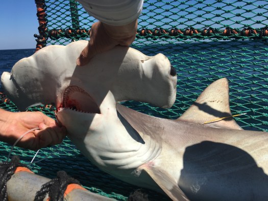
Here are some of my favorite videos and photos from the adventure.

Below a time lapse of what a haul back at night looks like


IMG_6686
Eye See you (Smooth-Hound shark)


Measuring a sandshark


And a video of my favorite shark- the great hammerhead being released out of the cradle.


And a baby hammy


So here I am, back in Flagstaff, reflecting back on my adventure. Did it really happen?  I have pictures to prove it and stories I am sharing but it does seem like a lifetime ago that I was touching a shark and looking into the doe eyes of a ten foot hammerhead shark.  The more I talk about what I have done, the more I realize how much I learned and how much more I still don’t know.  The two weeks flew by but I am grateful for it. So for those of you out there reading this blog, make time for adventures, get out there and do it, follow your passion and immerse yourself. You might be surprised at what you can do!


IMG_6040
Teacher at Sea Susan Brown


Susan Brown: Who Needs Sharks Anyway? September 13, 2017


NOAA Teacher at Sea

Susan Brown

Aboard NOAA Ship Oregon II

September 3 – 15, 2017


Mission: Snapper/Longline Shark Survey

Geographic Area of Cruise: Gulf of Mexico

Date: September 13, 2017

IMG_6406
sunset through jaws of a blacktip shark


Science and Technology Log

We have been sampling along the coast of Florida, Alabama, Mississippi, Louisiana, and Texas at varying depths – “A” stations ( 5- 30 fathoms), “B” stations (30 -100 fathoms) and “C” stations (100 – 200 fathoms). A fathom is six feet or approximately 2 meters. The longlines are baited the same – mackerel on 100 hooks spread out across one nautical mile and then set on the bottom of the ocean. As we reel in the long line, the click and whine of the line as it’s being spooled, we wait in anticipation of what it may bring. Each station yields something different and you never know what you are going to get. Below is a list of some of the animals we have encountered.


IMG_6286
baby hammerhead

Shark species: blacktip, sharpnose, blacknose, scalloped hammerhead, great hammerhead, bull, tiger, spinner and bonnet head (to learn more about each of these species, select it for a NOAA fact sheet).

IMG_6273.jpg
Scallop Hammerhead in cradle

Other animals: southern ray, cownose ray, roughtail stingray, red snapper, black drum, sharksuckers, catfish, red drum, yellowedge grouper, king snake eels and even some blue crabs.

So why survey sharks? Did you know that people are one of only a few species that prey on sharks — killer whales and other sharks are the others– killing over a hundred million per year?* Sharks are apex or top predators in an ocean food web and play a vital role in keeping this food web in balance. With the hunting of sharks as well as over fishing the prey that sharks eat we are disturbing the natural balance. This survey is used determine the number of sharks and other species that are present in the Atlantic Ocean including the Caribbean Sea and the Gulf of Mexico. With these numbers, the National Marine Fisheries Service (NOAA Fisheries) regulate how many sharks, swordfish and tuna can be harvested without impacting the total population. In the Pacific Ocean, NOAA fisheries work with fisheries in developing how to best manage sharks.

IMG_6731
red snapper

Apex predators in any ecosystem are vital to the health of that ecosystem. These top predators keep numbers down on the more abundant prey species and keep their numbers in check. Here is a simplified illustration of what happens when we lose apex (top) predators in an ocean ecosystem.

If the number of sharks goes down then the food the sharks eat goes up (forage fish) because they are not being eaten by the sharks. With more of those forage fish around their need for food – the zooplankton – increase. With more forage fish eating the zooplankton there are less zooplankton and their numbers begin to decrease. If there are less zooplankton then the phytoplankton numbers increase because the zooplankton aren’t around the eat them. Removing top predators from any ecosystem can have an impact on the entire food web and this phenomena is called a trophic cascade.

IMG_6489
Removing Hook

Personal Log

When people think of sharks, they think of the movie Jaws. Unfortunately this has given sharks a bad reputation and has vilified these animals that are essential to the ocean food webs. Sure, there have been shark attacks, but did you know that more people are killed each year by electrocution by Christmas tree lights than by shark attacks? When people imagine sharks, they think of enormous sharks that eat everything in sight. The reality is that sharks come in all sizes and shapes. A mature Atlantic sharpnose shark will only get to be 3.5 feet long with the world’s smallest shark being the dwarf lantern shark that can fit in the palm of your hand. The largest shark is the harmless-to-human whale sharks that feeds primarily on plankton and can grow up to 60 feet!

IMG_6084
Smooth-hound (Mustelus Sinusmexicalis)

Did You Know?

Scientists can tell the age of a shark by counting the rings on its vertebrae (similar to how they can tell how old a tree is by counting its rings!)

Question of the day:

What is an example of a terrestrial (land) apex predator that has been over hunted impacting the entire ecosystem?

hint: watch this video clip: https://www.youtube.com/watch?v=ysa5OBhXz-Q


Susan Brown: Making Waves, September 10, 2017

NOAA Teacher at Sea

Susan Brown

Aboard NOAA Ship Oregon II

September 3 – 15, 2017

Mission: Snapper/Longline Shark Survey
Geographic Area of Cruise: Gulf of Mexico
Date: September 10, 2017

Weather Data from the Bridge

Latitude: 29 24.526 N
Longitude: 094 22.228W
Sea wave height: 1 meter
Wind Speed: 16 knots
Wind Direction: 30.8 degrees
Air Temperature: 26.1 Celsius
Barometric Pressure: 1017.55 mb
Sky: clear


Science and Technology Log

We have been experiencing some rocking and rolling out here due to the hurricanes that are occurring to the east and the west of us as we sit in the relatively calmer waters off the coast of Texas and Louisiana. We have experienced 6 – 8 foot waves so far on our survey and the ship is being maneuvered to try and find the calmest spots so we can continue to do our work.

So what makes a wave a wave?

Check out this link to learn what makes a wave a wave!

https://oceanservice.noaa.gov/facts/wavesinocean.html

http://www.srh.noaa.gov/jetstream/ocean/images/gullloop.gif


Waves are part of the experience. Below is a poem written by the scientists and crew of the Oregon II on an earlier survey. Here are a few vocabulary words that you may not know to help you interpret the poem.


partsofawave
https://tasmancoast.wordpress.com/teacher-activities-for-yr-13-geo/a

Crest – the highest part of the wave
Trough – the lowest part of a wave
Muster – to call together
Haul back – the process of bringing in the longline
Bridge – where one controls the ship

Here is a poem written by some of the scientist and crew of the Oregon II about rough waters on an earlier expedition.


Trough-Man

The crew knows he’s on the job,
when the Ship starts to bob.

They know he’s at the wheel,
‘cause on the hip she does heel.
Trough-Man

On the Deck the haul-back team does muster,
while on the Bridge he robs sleep with the bow thruster.

You’ll always wake up in a funk,
‘cause you’ve been rolled out of your bunk.
Trough-Man

Sometimes you may wonder if he can
find the trough in a mug or a coffee can.

On this Ship you can’t even shave,
‘cause you never know when she’ll hit another wave.
Trough-Man

When the boat’s wallowing like a stuck pig,
you know he’s on the Bridge doing a jig.

For the rail you will grab,
when the boat does its crab.
Trough-Man

When you’re eating off your neighbor’s plate,
you know he’s your Shipmate.

If you can’t hold your food down and your stomach is off,
you know your riding in the trough.
Trough-Man

This poem is to all boat drivers, because they are put in the position of going from point A to point B no matter the sea state.

by Scientists & Crew of Oregon II Cruise 1102

Personal Log

We have had calm days where the water is like glass and other days with wind waves of up to 8 feet! I have come to appreciate the numerous handrails available all around the ship as well as learning to make sure my drawers and cabinets are secured. Nothing like waking up in the middle of the night with your drawers opening and closing! Also taking a shower in these conditions are quite the adventure in itself. The last few nights have felt like I am sleeping in a swinging hammock. There are also some nice features on the ship to keep items in place.


Here are some photos of the things I appreciate when the boat is rocking and rolling —  handrails that are located everywhere, hooks that keep doors open and holes in the picnic table to keep your drink from spilling!

Did You Know?

An oceanographic front is an area where two distinct water masses meet. Here is the one that we encountered on this last station. Why are these fronts important to birds and marine life? Extra credit for this bonus question!

FullSizeRender
See if you can see the two different colors of water

Question of the day:

Do waves transmit water or energy?

(hint: watch the video link https://oceanservice.noaa.gov/facts/wavesinocean.html)

Susan Brown: Weather or Not, September 9, 2017

NOAA Teacher at Sea

Susan Brown

NOAA Ship Oregon II

September 3 – 15, 2017


Mission: Snapper/Longline Shark Survey

Geographic Area of Cruise: Gulf of Mexico

Date: September 7, 2017

Weather Data from the Bridge

Latitude: 2095.92N
Longitude: 08825.06W
Sea wave height: 1.2 m
Wind Speed: 20.3kt
Wind Direction: 50 degrees
Visibility: (how far you can see)
Air Temperature: 025.6 degrees Celsius

Barometric Pressure: 1018.36 mb
Sky: cloudy

Science and Technology Log

The weather has been a big topic of conversation on this survey and for good reason. The original plan was to fish off the coast of Texas from Brownsville to Galveston. Due to Hurricane Harvey and possible debris in those waters, the survey changed course to sample off the coast of Florida. As we motored east, Irma was building up to a category 5 hurricane.

IMG_6031
Captain Dave


Captain Dave has been keeping a keen eye on the weather and after a few days of fishing off the coast of Florida, we headed back toward Pascagoula, Mississippi to pick up a crew member and let another off to tend to his family in Florida which is in the current path of Irma. We have been looking at the various computer modeling showing where Irma will land and this determining our path. Fortunately, a cold front to the west of us is pushing Irma east which will allows to stay out instead of docking and ending the survey early. This cold front is unusual for this time of year according to the Captain. Earlier models showed Hurricane Irma hitting the west side of Florida into the Gulf of Mexico where we are which would end our survey. Now, with the updated weather, we may get to stay out as planned but staying close to Mississippi and then heading West to work off the coast of Texas and Louisiana.

IMG_6331
Daily updates and rerouting due to weather

This ship is part of the Ship of Opportunity Program (SOOP). This program enlists ships to collect weather data that is sent to the National Weather Service (a line office of NOAA) every hour. This is the data that supplies information to weather forecasters! Information that is gathered includes wind speed and direction, barometer reading, trend in pressure over the past few hours, as well as wind, wave and swell information. Have you every noticed on TV that the weather reports have a notification that states the data is coming from NOAA? Weather forecasters get weather information from ships out in the ocean like the one I am on.

IMG_6323
another beautiful sunset from the top deck

This morning I headed up to the bridge to chat with Captain Dave. Here are some of the questions I asked.

Q: How long have you been a captain?

CD: 9 years

Q: What got you interested in this type of work?

CD:I grew up in Mississippi where you hunt and fish so when I got out of high school I always wanted to work on the water due to my upbringing. We were always taking out the boat to hunt or fish growing up. It’s in my blood.

Q: What is your schooling? What advice would you give someone that is interested in this as a career?

CD: I graduated high school in 1980 and made my living on the water commercial fishing and working on the oil rigs until January 4, 1993. I started as a deck hand and worked my way up to Commanding Officer (CO). I’ve been on the Oregon II 25 years. The hardest thing was taking the test to be a Master.

Captain Dave is a civilian Master which is rare – there are only two in the NOAA fleet. Most NOAA ships are run by NOAA Corps Officers. 

Q: What is the biggest storm you have seen?

CD: East of Miami, Florida in the gulf stream we were seeing 12-15 foot seas. The engine room calls the bridge regarding a busted intake valve. The boat was sinking. The engineers were in knee deep water and were able to find the broken valve and stop the flooding. In another 7 minutes the generator would have been under water and we would have lost power and would be forced to abandon ship in 12-15 foot waves.

Q: Is this weather unusual for this area this time of year?

CD: We never get a NE wind bringing in cooler weather which is probably what is turning Hurricane Irma. Normally it’s blazing hot here with southwest winds at 10 miles. This cold front is the reason we are not going in.

Check out this cool animated site for wind patterns. You can see how the hurricanes impact the flow of air.

https://www.windy.com/?47.680,-122.121,5

Personal Log

So far the seas have been calm and I keep expecting things to pick up because of all the weather happening around us. Sleeping pretty good with slow rocking of the ship and we will see how I do with some bigger swells. The crew has been super helpful in doling out advice from how keep from getting seasick ranging from eating, drinking and even how best to walk! I’m listening to all this advice and so far so good. I do wonder how much of Hurricane Irma we will feel now that we are heading west a few hundred miles.

IMG_6341
The one that got away!
IMG_6357
baiting the line with Mackerel
IMG_6393
Spinner shark

We have caught a few sharks and I am excited to catch some more. Other critters we have caught were a bunch of eels and a suckerfish. On yesterday’s shift I learned how to tag one of the big sandbar sharks. She was about 6’ long. The night crew caught a 10’ tiger shark! Maybe we will get lucky on today’s shift as I would love to see more sharks and handle some of the smaller ones.

IMG_6103
suckerfish

Update: Last night our shift brought in 16 sharpnose sharks so things were busy. These sharks don’t get much bigger than 3 ½ feet. All of the ones we pulled in last night were female. The oceans have gotten a bit rougher with swells 4-5 feet! I have gained a new appreciation for all the rails available along the corridors of the ship and have learned to make sure my door is clicked shut as well as all the cabinets and drawers. Nothing like waking up to drawers slamming open and shut in the middle of the night!

Did You Know?

A Captain of the ship can be ranked as a Captain or a Commander within the NOAA Corps but a civilian does not hold a commissioned rank because they are not in the NOAA Corps and is called a Captain since he holds a Master license gained by taking extensive coursework and an intensive exam through the United States Coast Guard.

Question of the day:

What is the difference between a category 5 hurricane and lesser hurricanes? (hint: check out the link below)

http://abcnews.go.com/US/hurricanes-form-explained-abc-news-chief-meteorologist-ginger/story?id=49650211


Susan Brown: So You Want To Study Sharks? September 6, 2017


 NOAA Teacher at Sea

Susan Brown

Aboard NOAA Ship Oregon II

September 3 – 15, 2017


Mission: Snapper/Longline Shark Survey

Geographic Area of Cruise: Gulf of Mexico

Date: September 6, 2017


Weather Data from the Bridge

Latitude: 29 51.066 N
Longitude: 088 38.983W
Sea wave height: .3 m
Wind Speed: 11.6
Wind Direction: 5.3 degrees starboard
Visibility: (ask bridge)
Air Temperature: 27.5 degrees Celsius

Barometric Pressure: 1014.88 mb
Sky: cloudy


Science and Technology Log

Lisa Jones is a fisheries biologist and the field party chief responsible for planning and logistics, manning the survey and the day to day operations. She is in charge of the science team. The Captain, Captain Dave Nelson, is charge of the ship. These two work together on the Oregon II making decisions on where we go.

Lisa has been doing this for 20 years and has been to locations including the Gulf of Mexico, Cuba, California, the western north Atlantic, and Mexico. The research has varied from a focus on shark/snapper like the one we are on to marine mammals, plankton, aeriel surveys, and harbor seals. Here are some of the questions I asked. 

Q: What is the most interesting thing you have brought up from the ocean?

L: As far as sharks are concerned, one year off the Florida panhandle, we caught a sixgill shark so big we couldn’t even tag it.

Q: How big do you estimate the size of that shark?

L: Approximately fifteen feet

Q: What got you interested in sharks?

L: When I was working for the Cal Fish and Game, radio tagging and doing aerial surveys for harbor seals, we would see shark bitten seals as well as sharks during the aerial surveys. One of the coolest things we ever saw off the Channel Islands was a blue whale. 

Q: Those are big, right? How big do you think it was?

L: I don’t know but it looked liked a small building in the water.

Q: What is your training?

L: My undergraduate degree is in geology. I took a lot of oceanography classes during that time. Later, in my 30s, I went back to graduate school for a degree in biology in Tennessee. It’s a long story but I knew I wanted to study sharks. Land locked in Tennessee, I attended a national conference that included many shark specialists. I introduced myself to get connected – basically anyone who would talk to me.

Lisa Jones explains a career in shark research, part 1:

Lisa Jones explains a career in shark research, part 2:

What questions do you have for Lisa? Post them in the comment section. She is happy to answer them!

Personal Log

I am adjusting to life on the ship and the 12-hour shifts. It’s been fun learning all the different jobs we have as we rotate through different stations. I have now baited hooks, recorded data on the computer as we deploy baited hooks and retrieve the longline to record what we catch, a slinger where I get the baited line ready to be attached to the longline, the high flyer pushing the buoy out that marks the start and end of the longline, and even tagged a large sandbar shark.

Check out this video of me slinging the bait:

There have been several questions regarding our route. The survey area has changed due to both Hurricane Harvey and Hurricane Irma. The next post will be all about weather so you can see how this has impacted our trip. I am wondering how much these hurricanes have impacted what and how much we catch.


Did You Know?

Salinity and dissolved oxygen in the water impacts what we catch.


Question of the day:

What advice did Lisa give for anyone interested in doing the kind of work she does? (hint: watch the video embedded in this post)

Susan Brown: Probing for Parasites, September 5, 2017

 NOAA Teacher at Sea

Susan Brown

Aboard NOAA Ship Oregon II

September 3 – 15, 2017


Mission: Snapper/Longline Shark Survey

Geographic Area of Cruise: Gulf of Mexico

Date: September 5, 2017


Weather Data from the Bridge (get data from bridge)

Latitude: 29 degree 36.0 N
Longitude: 86 degree 10.1 W
Sea wave height: < 1
Wind Speed: 7 kts
Wind Direction: 185
Visibility: 10 nm
Air Temperature:
Barometric Pressure: 1016.3
Sky: BKN

Science and Technology Log

The Oregon II has two sets of crew – the ship’s crew headed by Captain Dave Nelson and the science crew headed by Lisa Jones. Captain Dave and Lisa work closely together making decisions that impact the survey. The ship’s crew keeps us afloat, fed and ultimately determines where we go based on weather. The science crew, well you guessed it, is focused on the science and collected data at predetermined sampling sites.

This post will look at some of the science happening on board. On board are four NOAA scientists as well as other volunteers and researchers that are helping with this survey. NOAA’s focus on this survey is all about sharks and snapper. We are collecting data on what we haul up from the longlines as well as abiotic factors including temperature, depth of line, dissolved oxygen, and salinity of the water. The data is entered into a computer and becomes part of a larger data set.

IMG_5865
NOAA parasitologists Carlos and Brett

Two researchers on board working as volunteers are Brett Warren and Carlos Ruiz. They are parasitologists meaning they study parasites that sharks and other organisms carry. A parasite is an organism that lives off other organisms (a host) in order to survive. They are finding all sorts of worms and copepods embedded in the nose, gills and hearts of fish and sharks. These two spend much of their time using microscopes to look at tissue samples collected.

IMG_5953
Brett looking for parasites

In speaking with Brett, the life cycle of parasite can be simple or complex. The simple direct life cycle is when the parasite spends its entire life on the host organism. A complex indirect life cycle for a parasite is when the parasite reproduce, the young hatch and swim to an intermediary host, usually a snail, mollusk or polychaete. This is where it gets really cool, according to Brett. It’s the intermediate host where the parasites asexually reproduce by cloning themselves. Next, the parasite leaves the intermediate host and swim to their final host and the process starts all over again. From a parasite perspective, you can see how difficult it would be for an indirect life cycle to be completed, because all the conditions need to be right. Brett is studying flatworms that have complex lifecycles and Carlos is studying copepods that have direct life cycles.

IMG_6106
Can you guess what this is? Answer in the comments and first right answer gets a prize!

Their main focus on this survey is to discover new species of parasites and understand the host- parasite relationship.


Personal Log

The past few days have been slow with only a few stations a shift. We have hauled up some sharks, eels and even a sharksucker fish. One station had nothing on the 100 hooks set! Talk about getting skunked. As we move west I am hoping we get to see more sharks as well as more variety. Other wildlife spotted include dolphins, jellyfish and birds.

IMG_6130
Finding the length of a sharpnose shark
IMG_5851
size of hooks we are using

Did You Know?

Just because it’s a parasite doesn’t mean it harms the host. Some just live off of another organism without harming it.


Question of the day:

What are the two types of life cycles a parasite can have? (hint: read the blog)

Susan Brown: Let’s Go Fishing, September 4, 2017


NOAA Teacher at Sea

Susan Brown

NOAA Ship Oregon II

September 3 – 15, 2017

Mission: Snapper/Longline Shark Survey

Geographic Area of Cruise: Gulf of Mexico

Date: September 4, 2017

Weather Data from the Bridge

Latitude: 29 43.931N
Longitude: 086 09.617W
Sea wave height: .5 meters
Wind Speed: 2
Wind Direction: 250 degrees
Visibility: good
Air Temperature: 28.3 degrees Celsius
Barometric Pressure: 1016 mb
Sky: partly cloudy

Science and Technology Log

Numbered tags used for each hook
Mackerel used for bait

Today was my first shift. We are using mackerel to bait the 100 hooks that will be places into the water at a specific station. Each hook is numbered so that we can collect data on which hook brought in a fish and entered into the database. There are several jobs out here from baiting the hooks, placing the buoys, flinging the baited hooks out, and recording data in the computer. My job today is the computer.

entering data on the deployment of the baited hooks

The longline is set and left to sit in the ocean for approximately one hour before we start bringing up the line to see if we have a fish on. Out of the 100 hooks we got one fish, a baby tiger shark and a larger juvenile tiger shark coming in at six feet or so. This tiger shark had several hooks in its mouth as well as a tag so when she was brought up on board, all the hooks were removed and the tag replaced with a new one.

IMG_5947
Removing hooks from the tiger shark’s mouth

The tag that was on the tiger shark was opened up to reveal a small scroll of paper with a unique number so that this shark can be tracked from where it was first picked up to when it ended up with us for the brief visit. Below is a short video of us bringing up the shark in the cradle! [no dialogue or narration.]

We will be setting another line tonight at our second station as we continue to motor southeast following the coast of Florida.

Beside recording data on the sharks, a CTD is deployed to collect data on conductivity, temperature and depth. We will use this data in the classroom to look for trends between the abiotic factors that may influence where we are finding certain shark species and the number of overall sharks at any given station.

The CTD that measure conductivity, temperature and depth

Personal Log

There are many different scientists on board researching different things. I am sharing a stateroom with Dani who is on the night shift. She is looking into how different sharks handle stress. I see very little of her since we are on opposite shifts so we get a quick visit at noon when there is a changing of the guards so of say. Brett and Carlos, as mentioned in an earlier post, are looking into parasites that inhabit the various animals we are bringing up. I will do a separate blog on those two and their research later this week to share what they are finding.

Donning the survival suit during abandon ship drill

Today we had a few drills to practice in case of an emergency. One was a fire drill and the other was an abandon ship drill where I had to don a large neoprene suit in less than two minutes. Here I am in that suit! It was quite cumbersome to put on.

Learning new words as I get acclimated to the ship. Here are a few for you:

The head = bathroom

Stateroom = room where I sleep

Muster = to assemble

Bow = the front of the ship

Stern = the back of the ship

Did You Know?

Military time is used on board this ship. See the photo of the clock below.

Question of the Day: Why use military time?

NOAA clock

Susan Brown: Getting Acclimated, September 3, 2017

NOAA Teacher at Sea

Susan Brown

Aboard NOAA Ship Oregon II

September 2 – 15, 2017

Mission: Shark/Red Snapper Longline Survey
Geographic Area of Cruise: Gulf of Mexico
Date: September 3, 2017
Weather Data from the Bridge

Latitude: 30degree06.7N
Longitude: 88degree17.6W
Sea wave height: <1
Wind Speed: LT
Wind Direction: VAR
Visibility: 10NM
Air Temperature:
Barometric Pressure:
Sky: BKN

Incomplete weather data as we were docked.

I’m currently sitting on the Oregon II docked in Pascagoula, Mississippi after a long travel day. It’s eerily quiet as the ship disembarks tomorrow at 14:00 and the majority of the crew will arrive tomorrow. I am enjoying the slow introduction to this ship and finding my way around. The OOD (Officer Of the Deck) gave me a tour of the ship that I will be working on for the next two weeks. The majority of crew is on shore for the Labor Day weekend but will return tomorrow as we disembark and head towards Florida. Our plans have changed due to Hurricane Harvey and debris that may be in the waters making the travel in those waters unsafe.

IMG_5813
NOAA Ship Oregon II in dock

Science and Technology Log

Due to Hurricane Harvey, the area being surveyed has changed so that we are heading East instead of West to pick up the third leg of this survey that ended off the coast of Florida last week. I have been assigned the day shift from noon to midnight and will be assisting the science crew. The mission of this survey is to monitor interannual variability of shark populations of the Atlantic coast and the Gulf of Mexico. Additionally aboard are two scientist that are on board are studying parasites that these animals carry. Carlos and Brett, the two parasitologists, were on the second leg right before I joined. Their leg started on the tip of Florida and ended where we will start.

Personal Log

IMG_5855
Wearing “the patch” to keep from getting seasick

Seasick? Felt a little queasy after my first night in dock! Decided the best course of action was to take some medicine, eat a big meal and hydrate to help get my sea legs. Everyone has been friendly and welcoming as we get started. The night crew starts tonight at midnight till noon and the day crew, where I am been placed, will start at noon. Hoping for a good night’s sleep!

IMG_5798
My bed is the bottom one!

Did You Know?

Sharks have been around since the dinosaurs approximately 450 million years ago.

Question of the day

What is NOAA’s mission statement? (Hint: Google NOAA and select “About Our Agency” at the bottom)

Susan Brown: Adventure Awaits, August 24, 2017

NOAA Teacher at Sea

Susan Brown

Aboard NOAA Ship Oregon II

September 2 – 15, 2017


Mission: Shark/Red Snapper Longline Survey

Geographic Area of Cruise: Gulf of Mexico

Date: August 24, 2017


Weather Data from the Bridge

I’m currently at home in Flagstaff, Arizona. It’s a typical, monsoon season morning coming in at 11.6 degrees C (53 degrees F) at 7:12 am with humidity at 92%. I’m about 1,700 miles away from Pascagoula, Mississippi, where I will be joining the team on our ship, NOAA Ship Oregon II, in just a few days!

NOAA Ship Oregon II Sunset_NOAA Photo
NOAA Ship Oregon II. Photo credit: NOAA

NOAA Ship Oregon II Photo Credit: NOAA

Weather Data from my desk at school:

Latitude: 35.190807
Longitude: -111.65127
Sea wave height: NA
Wind Speed: 2 Mph
Wind Direction: NW
Visibility:
Air Temperature: 11. 6 degrees C
Barometric Pressure: 29.84” falling Rapdily
Sky:  scattered clouds


Science and Technology Log

Once on board, I will be assisting the science crew with the third leg of the Shark/Red Snapper Longline Survey and will be fishing from Brownsville, TX to Galveston, TX. The mission of this survey is to monitor interannual variability of shark populations of the Atlantic coast and the Gulf of Mexico.

longline_sampling_area
Map of the survey area: the Atlantic coast and the Gulf of Mexico.

My understanding is that we will be working a 12-hour shift using longline gear to capture specimens and measure the length, weight and sex of the animal. The longline is baited with Atlantic Mackerel and will sit in the water for one hour. Here is what longline gear looks like:


longline_gear_illustration
Illustration of longline gear. Credit: NOAA


The larger animals will require landing slings! I can’t even imagine. The science crew will also be tagging the animals as well as retaining a few for research. Finclips, like taking a nail clipping, will be gathered for DNA analysis. I am most excited to get up and close with these wonderful creatures tagging them to monitor their movement and health.


shark_measure2_small
Measuring a tiger shark. Photo credit: SEFSC


shark_measure1
Measuring a shark. Photo Credit: SEFSC


As part of the survey we will be gathering CTD (Conductivity Temperature Depth) data that provides a surface to bottom profile of temperature, salinity, dissolved oxygen, chlorophyll, turbidity and depth. As a class, we will be learning about these in depth in the classroom when we reach our unit on water quality in relation to our local watershed.

Personal Log

I am getting excited for this adventure and happy to have you along for the journey. I look forward to your questions and can’t wait to learn about these beautiful creatures while working with scientists. Please makes sure to check out the “Question of the Day” and other activities that will be posted on this blog. Your current research on sharks will come in handy while I am out here and will be crucial to learning about ocean food webs and current threats. Remember to check in daily for new posts while you are working on your projects.


Did You Know?

That I have never been to the Gulf of Mexico!


Question of the day

What species of shark live in the Gulf of Mexico?