Sue Oltman: Salinity and Seamount Sleuths, May 24, 2012

NOAA Teacher at Sea
Sue Oltman
Aboard R/V Melville
May 22 – June 6, 2012

Mission: STRATUS Mooring Maintenance
Geographical Area: Southeastern Pacific Ocean, off the coast of Chile and Ecuador
Date: May 24, 2012

Weather Data from the Bridge:
Air temperature: 18.3 C / 64.9 F
Humidity: 70.3%
Precipitation: 0
Barometric pressure: 1011 mB
Wind speed: 2.3 NNW
Sea temperature: 19.16 C

Personal Log

The weather has been terrific – clear, in the 60’s with a little wind, nice sailing with the current helping us along. We are in the trade winds region. The view from the bridge (Captain’s pilot house) is excellent.  Everyone is terrific and very patient in showing us the ropes. There’s plenty of time to get to know people.  I’m getting to practice my Spanish a bit with our 2 students from the University of Concepcion (Chile) and two more Spanish speakers, from Chile and Ecuador. The two others on watch with me are Seb Bigorre (WHOI) and Ursula Cifuentes, a grad student from Chile, so we speak some Spanish during the watches. Life on a ship is different, but some of the comforts of home are here, too. Thank goodness there is a laundry, otherwise I would have had to bring 3 weeks worth of clothes! The food has really been fantastic!

Mark serving up some great food
Mark is one of our friendly cooks who keeps everyone on the ship happy!
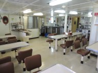
Mess deck
The mess deck is where we eat our meals, grab a snack, or sit to read or chat at off times.

The dinner tonight is carne asada (fajitas) and you can smell it cooking. Bob and Mark, our cooks, have also served us white bean chili, salads, cheeseburger sliders, roasted chicken, fish, pork roast and vegetables, seasoned hash browns, bacon and eggs, all kinds of fresh fruit, not to mention the desserts like blueberry cobbler and cinnamon rolls. 

With all this great food, I was thankful to find that the crew makes places on the ship to work out! Some do “laps” by walking the ship a few dozen times around. There is an exercise room with weights and bikes and more equipment can be found in other places around the ship.

Science and Technology Log

The Woods Hole UOP (Upper Ocean Processes group) and rest of the team is now in a rhythm of deploying probes and gathering data. Like super sleuths, we are tracking a cold, relatively fresh water mass which originates inValparaiso and moves northwest. This water mass lies under the warm, salty surface layer.  At 50 meters depth, there is a clear distinction in the water masses since we began deploying the UCTDs. Just like a detective matches fingerprints, we have a “fingerprint” of the cold, fresh water.  A seasonal thermocline has been identified! Nan Galbraith, a programmer from WHOI, is processing all of the numerical data into useful images.  The surface water layer (graph) has a temperature about 20º C and salinity > 35 ppt (parts per thousand). At 50 meters depth, the temperature abruptly drops to 17º C and falls to 7.5º C at 400 m which is the bottom depth we are testing; similarly the salinity drops to 34.1 ppt. Although we are traveling through water about 4,000 m deep, we are interested in tracking this water mass. I’m still having trouble remembering approximate Celsius to Fahrenheit conversions: here’s a link to help.

http://www.wbuf.noaa.gov/tempfc.htm

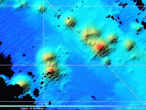
However, another factor has come into play which we must consider. We are nearing a tectonically active area – the Nazca Ridge, a fracture zone. There are many seamounts, some of which have not been previously mapped. Whoever is on watch must look at the ever-changing multi-beam sonar display to look for seamounts – we don’t want the instrument to slam into an underwater volcanic mountain! The closer we get to the Nazca Ridge, the higher the likelihood of seamounts.
Seamounts
We constantly monitor the multi beam sonar display for bathymetry and sea floor features. The red or yellow circular areas are seamounts.

All in all, we will cover about 2,268 miles until we reach the Galapagos, so the multibeam sonar is a critical piece of navigation equipment.

On the watches, as we deploy the UCTD probe, which looks like a 2 foot long bullet, weighing about 10 lbs., and good teamwork is the hallmark of a successful launch and recovery. Sometimes we are working in the dark with only the ship’s lights and a flashlight. I have learned how to make a splice in the line – the cord is only about 1 mm in diameter! This line and any splice must be strong enough to hold onto a 10 pound instrument being dragged though 400 m of water at 12 knots. Picture 3 people at 4 a.m. on a moving ship, using tiny instruments to sew a splice in a 1mm line, all while the line is attached to the winch. Like a surgical team, we are all focused and know what tool the splicer needs next. Sometimes quick thinking and a problem solving mindset is needed. There was a foam “bumper” that we had been attaching to the line to cover the probe when it got close to the boat. The probe is expensive and this was protection from it slamming into the steel fantail. When it was lost in the water, the team on watch used a nearby mop to protect the probe while reeling it in. On the next watch, Seb figured out a different solution.

Why does it smell like diapers in here?

Back in the lab a different bit of problem solving with the scientific method is going on! Often when buoys are recovered, they are fouled — covered with barnacles and all kinds of organisms, fishing line, etc. that get caught in them. Jeff Lord – mechanical whiz – has hypothesized that applying a better “anti-fouling” substance can keep these from affixing themselves to the equipment. He has liberally applied Desitin, a zinc oxide ointment, to the instruments. This is the same treatment for diaper rash on babies’ bottoms!  So therefore, the odor in the lab reminds us of diapers. It will be a year before we know if Jeff’s hypothesis is correct, because after the STRATUS 12 buoy is moored, it will be a year before it is recovered.  What do you think will happen?

Some of the science party was given a tour of the ships technical equipment behind the scenes. Bud Hale explained not only all of the monitors and ship terminology, but took us down into the equipment rooms where we encountered a gravimeter (measures gravity variations), modern gyros with optics and GPS (measures pitch, roll and heave).

Bud Hale
Bud is an expert on all things technical on the ship. He is more than happy to tell you how any of it works!

Tomorrow, we hope to see the desalination plant on the ship which gives us our fresh drinking water.

UCTD files
After each deployment of a UCTD, data is uploaded into the computer. I’m starting to get the hang of it!

Cathrine Fox: Issue Fourteen: Late Night Television

NOAA TEACHER AT SEA
CATHRINE PRENOT FOX
NOAA SHIP OSCAR DYSON
JULY 24 – AUGUST 14, 2011


Personal Log:
Late night television=brain torture. I think late night t.v. might be designed to shrink brain neurons: shopping networks, exercise shows, self help and reality programs. Some studies have even linked watching late night t.v. to obesity and sleep deprivation. I’d rather stab myself with a butter knife than be trapped on a couch watching a self help guru in the middle of the night… …On the Oscar Dyson, though? You couldn’t drag me away from the 4:30 a.m. screen, as it shows a live feed of the floor of the ocean 100 meters below us.

The camera drops were just one part of the night-time research aboard the Oscar Dyson. Dr. Jodi Pirtle, a post doctoral research associate at the University of New Hampshire Center for Coastal and Ocean Mapping, utilized her lab hours to explore and document “untrawlable” portions of our survey area. Rocky bottoms, pinnacles, shelves… …all make it difficult to drop a net down to get an accurate reading of groundfish diversity and abundance without destroying the net.

Throughout the night the ship maneuvers tight turns to provide high resolution acoustic signals of the bottom. My fellow Teacher at Sea, Staci DeSchryver, describes the ship’s movements as akin to “lawn mowing.” My father, watching the NOAA ship tracker online after one of these sessions, asked if the captain had had one too many cocktails (absolutely not, by the way). These turns, in addition to making me sleep like a baby, provide an overlapping and highly accurate map of the ocean floor. Below is a multibeam image of a seamount (underwater mountain) mapped during the 2004 Gulf of Alaska Seamount Expedition.

"In this multibeam image of Ely Seamount, the caldera (aka the Crater of Doom) is visible at the apex of the seamount." Image courtesy of Jason Chaytor, NOAA
“In this multibeam image of Ely Seamount, the caldera (aka the Crater of Doom) is visible at the apex of the seamount.” Image courtesy of Jason Chaytor, NOAA

After a night of intensive napping, I mean mapping, I go on shift at 4am. I know I have mentioned this before, but I have the best job in the world: my first task in the morning is helping with camera deployment. I am sure you will agree after checking out Issue 14 that several camera drops equal the best Late Night T.V. I have ever seen (Cartoon citations 1 and 2).

Adventures in a Blue World, Issue 14

Until our next adventure,
Cat

Retrieving the camera. Snakehead.

Not to be redundant, but the best job ever.

Geoff Goodenow, May 7, 2004

NOAA Teacher at Sea
Geoff Goodenow
Onboard NOAA Ship Oscar Elton Sette

May 2 – 25, 2004

Mission: Swordfish Assessment Survey
Geographical Area:
Hawaiian Islands
Date:
May 7, 2004

Time: 1615
Lat: 18 41N
Long: 158 34W
Sky: scattered cumulus clouds; bright and sunny
Air temp: 26.6 C
Barometer: 1012.04
Wind: 87 degrees at knots 6.7 knots
Relative humidity: 50%
Sea temp: 26 C
Depth: 4558 m

Scientific and Technical Log

We left the shelter of the Kona coast and steamed all night toward Cross seamount arriving there between 0900 and 1000 hours. We trolled a couple lines across it for several hours but pulled in no fish. This is where we wanted to lay the line tonight, but in communicating with a fishing vessel in the area, that crew indicated they have 30 miles of line in the water now. Protocol, I presume, says it’s their place for now so we will respect that and go elsewhere.

Elsewhere is another seamount about 45 miles west and slightly north of Cross. But why are we hanging out at these things called seamounts? Rich (remember, chief scientist) explained to me that above seamounts are local currents called Taylor Columns that sort of swirl around above these features. Small fish tend to concentrate within these and, of course, that attracts the big boys. Cross is well known for that effect due to its shallowness (182 fathoms). The one we are going to is much deeper and consequently does not have as dramatic an impact as Cross.

Here is a bit about a couple tools that we are not using on this ship for this mission. One is called the Acoustic Doppler Current Profiler. It sends out a high frequency signal and allows determination of current direction and speed under the ship. Another is the CTD (conductivity, temperature and depth). This circular array of water sampling bottles is lowered into the water. Temperature and conductivity are monitored and recorded continuously as it moves through the water. On ascent, bottles can be triggered to close at specific depths thereby bringing water samples from different levels in the water column for further testing on board.

Personal Log

More about life on the ship:

There will be no shore time during this trip, but there are several forms of entertainment aboard. Just listening to crew members speak of other places and projects around the globe they have participated in on NOAA vessels is fascinating. There is a small work out room and a couple rooms where we can view videos/cds or watch TV. There is quite a library of viewing materials and books available. Some crew members have their own TVs and stereo equipment in their cabins. On the more mundane side, there is a laundry to do personal items and once a week stewards give us a change of linens and towels.

Communication with home:

We download and upload email three times per day: 0700, 1300, and 1900 hours. Phone calls can be made but they are expensive and generally reserved for emergencies. The ship’s total communications bill can run up to $10,000 per month. So far, a typical day for me has been something like this after breakfast (0700-0800): collect samples from longline catch, assist cleanup, cleanup self, lunch (1100-1200). Check emails, enter some notes to log until tiring of that, R&R (reading, snoozing on shaded deck, interview someone or observe their work) and help with any fish coming in on troll lines. Dinner (1630-1730), R&R, input to log, help set longline (2000 -2130), finish the day’s log and send to Washington (that makes me sound pretty important doesn’t it?), R&R, and to bed 2300-2400 hours.

Since we did not set a line last night and no fish came on by trolling today was kind of slow. I used the time to have a tour of the bridge by executive officer Sarah and electrical technician, John. It was very interesting to learn more about the ship’s scientific monitoring abilities (as briefly and incompletely described above), navigation and safety features for times of distress.

Crew assisted me to string my swordfish bills so to drag along behind us. This is done to get some of the flesh and oils out of them. I am told that this will take a week or more to accomplish.

Questions:

Estimate the distance in miles between yesterday’s and today’s position (today at 2018 hours we are at Lat 18 53 N and Long 158.59 W).

What is a seamount?

Looking at the nautical chart on the bridge I can see the top of Cross seamount is at (a shallow) 182 fathoms. We are headed to one that is 406 fathoms. Between the two the chart shows a maximum depth of 2585 fathoms. What is the depth of the water over the seamounts and the deepest point between them in feet?

Geoff