Helen Haskell: Watching the Wildlife, June 15, 2017

NOAA Teacher at Sea

Helen Haskell

Aboard NOAA Ship Fairweather

June 5 – 26, 2017


Mission: Hydro Survey

Geographic Area of Cruise: Southeast Alaska – West Prince of Wales Island Hydro Survey

Date: June 15, 2017

Weather Data:

Wind: 3 knots from the west

Visibility: 6 nautical miles

Barometer: 997.6 hPa

Air temperature: 9°C

Cloud: 100% cover, 1000’

Location:

54°54.4’N 132°52.3’W

Science and Technology Log:

While Fairweather is a hydrographic research ship, responsible for collecting data for navigational charts, one of the side reports the survey crew makes is a Marine Mammal Observation Log. When a marine mammal is spotted on a survey, its location is noted, the species is identified if possible and notes about the numbers, behavior and any other observations are documented. Along with documenting sightings of these animals, the coxswains also follow protocols for minimizing disturbance and impact to these creatures.

Since joining this leg of the hydrographic research, humpback whales (Megaptera novaeangilae) have been the most numerous whale species seen. These whales that spend the summer in South-east Alaska winter mainly in Hawaii. Mating happens during the winter and the calves are born 11 months later. The calves stay with their mother for about 11 months after they are born. Individuals can grow up to 60 feet in length and live 50 years. These large grey whales have numerous barnacles that attach to their skin and filter feed as the whale travels. It is thought that the whales find shallower rocky areas to swim alongside in order to rub off the barnacles. It was in some of the shallower survey areas that I first saw humpbacks.


Harbor seals have fast become one of my favorites during my time here in Alaska. Growing to about six feet in length, the harbor seal, Phoca vitulina, have a diet of shellfish, crustaceans and fish and appear to be non-migratory, staying here year round. They are grey in color and can weigh up to 250 lbs as a mature male. Data seems to suggest that in some areas of their range in Alaska, the populations are declining but in other areas, seem stable. As the seals give birth in the summer, we’ve been fortunate enough to see seal pups too on this leg of the research.


The Northern sea otter, Enhydra lutris kenyoni, has perhaps been the most numerous marine mammal so far on this trip. Appearing small next to the seals and whales, upon reading more about them, I learned that they not small creatures, as they measure up to five feet in length and weigh up to 100 lbs. Feasting on a diet of invertebrates, such as clams and sea urchins, the sea otters are often spotted floating on their backs and are often associated with kelp beds. The otter fur trade began in the 1700’s and by 1900 populations were on the brink of extinction. Legislation has allowed the populations to rebound in most areas in the last 100 years, and they are seen regularly by survey crews and from the bridge.


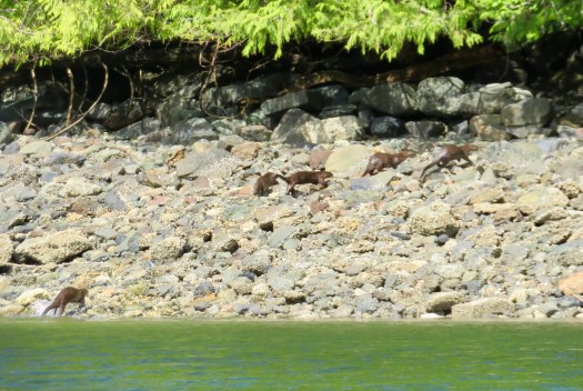
Another species I saw here, up a small shallow cove, was the river otter, Lutra Canadensis. Five heads popped up in front of me and then bobbed under. Seconds later the otters were up on land running in to the trees. Seemingly fast and sleek, they were not acting like sea otters. It was not any behavior we had observed before. A little bit of research confirmed our suspicions that these were indeed river otters. Sea otters rarely come out on land, and when they do, do not move swiftly, having more flipper-like back legs, making land movement more arduous. River otters are smaller than sea otters weighing up to 35lbs and are 40-60 inches in length.

IMG_0109

While obviously not a marine mammal, the bald eagle is pretty much a guaranteed daily sight as the surveys are being done. A friend referred to the bald eagle as an Alaskan pigeon, and while I have not experienced as many bird species or numbers of birds here as I thought I would, the eagle has been one of the main species sighted. With an estimated population of 30,000 in Alaska, more numerous here than any other state, that hasn’t always been the case. With bounties on them at the turn of the 20th century, and population reductions due to pesticides and habitat loss, especially in the lower 48 states, the bald eagle, Haliaeetus leucocephalus, was put on the Endangered Species List in 1967. Measures put in place both locally and nationally have been so successful that in 2007 the bald eagle was removed from the Endangered Species List.


Another species I have seen regularly but not up at close range, is the Marbled Murrelet, Brachyramphus marmoratus. These small, almost 10 inch long marine birds are in breeding plumage right now and, although they have been hard to see, due to distance and poor light conditions in the rain, are beautiful shades of brown and cinnamon. They build nests here in southeast Alaska in the mossy branches of old growth conifer trees or on the ground.

IMG_0346
A little blurry but here are the Marbled Murrelets


Personal log

While it’s easy to get sidetracked with the mammals and birds here, there is a host of other species here that play significant roles in the food web. Kelp has been one of the organisms that I’ve seen a lot while doing the small boat surveys, and on our first completely sunny day, I got the chance to get up close and personal with the kelp from the vantage point of a kayak. The Fairweather has several kayaks that on occasion the crew uses to explore the local area. Together with NOAA Corps Junior Officer ENS Peter Siegenthaler and Hollings scholar Carly Laroche, we filed a Small Boat Plan with the bridge, stating where we were going and our anticipated return time, picked up radios, and carried the kayaks down from the top deck. It’s a little tricky to get a small kayak in the water from a large ship, but with the help of a small boat, we launched and paddled, in almost glassy water, over towards the shoreline.

FullSizeRender (1)
Me in one of the kayaks

Being even closer to the water in a shallow keel-less boat, allowed us to paddle through those kelp forests, pick up the otter-opened clamshells and explore the intertidal community much more easily. We were also able get close to some of the terrestrial species, the Sitka spruce and the other trees species growing vertically out of often steep slopes, right down to the high tide mark. We paddled along these inter-tidal edges listening to hermit thrush sing from the trees up the hillsides as we debated how logging companies actually cuts trees on such steep slopes. It was a glorious day, a rare sunny, calm day in the early summer of southeast Alaska, and perfect for paddling. This area is filled with small islands and coves, waiting to be explored, especially at low tide, when more inter-tidal life is exposed. My fingers are crossed that the weather and water conditions will allow for more explorations by kayak before I have to leave Fairweather in Kodiak.


Fact of the day: KELP

There are three species of kelp found here in southeast Alaska: bull kelp, ribbon kelp and sugar kelp. Kelp is an algae, not a plant, although it does photosynthesize. It is an essential part of the ecosystem here and many species are dependent on it.

Word of the day: Baleen

Humpbacks are a baleen whale, meaning that they have these plates, up to 600, make out of a substance called keratin in their mouths that act as filters in feeding. The keratin is referred to as baleen and is similar to our fingernails. In an earlier blog posting I held up a piece of baleen in an art store in Ketchikan. Below is a picture of baskets woven out of strips of baleen.

IMG_0122

What is this?

(Previous post: The picture is of the sonar equipment on the bottom of the small boats).

IMG_0147

Helen Haskell: Life on a Ship, June 7, 2017

NOAA Teacher at Sea

Helen Haskell

Aboard NOAA Ship Fairweather

June 5 – 22, 2017

Mission: Hydrographic Survey

Geographic Area of Cruise: Southeast Alaska – West of Prince of Wales Island 

Date: June 7, 2017

Weather Data from the Bridge:

Latitude: 55 04.473 N

Longitude: 133 03.291 W

Wind: 9 knots from the east

Air temperature: 17C

Visibility: 10 miles

Barometer: 1004.2 hPa

Science and Technology Log

The mission of the Fairweather is to conduct hydrographic surveys for nautical charting. The Fairweather does this work in the waters off the United States Pacific coast, but principally in Alaskan coastal waters. The data is collected using sonar both by the Fairweather but also using a series of smaller boats that are launched as often as possible, each with a small crew of 3-4 people. These smaller boats are able to conduct the surveys much closer to the shoreline, and spend about 8-9 hours each day surveying a specific region. Many of the waters up here have had no recent data collected, and mariners are relying on charts that may have measurements taken in the 1800’s or 1900’s when technology was very different.

IMG_0282
NOAA Ship Fairweather

During the field season, Fairweather spends about 210 days at sea. During the rest of the year, the Fairweather stays at her homeport, allowing the crew to work on maintenance issues, take leave, work on the data and outfit the boat for the following season. During the field season, the boat conducts different legs of the research, spending 12-20 days out at sea at a time before returning to a port to re-supply. There are six departments on the ship: Command, Deck, Electronics, Engineering, Steward and Survey. Each person on the ship is hired with specific duties and responsibilities.

As a government vessel, the Fairweather is also available for use during the time of war or in case of an emergency. In the event of something along these lines, the ship and the officers would be transferred to the Armed Forces of the United States.

The Fairweather is named after the tallest peak in the Fairweather range in Alaska. The ship served in Alaskan waters for over 20 years but was decommissioned in 1988. In 2004, due to increasing demand for modern surveys in Alaska, it was retrofitted and put back in to the research fleet. Previously staterooms housed up to 4 people, but after the retrofit a maximum of two people share a room. The boat can house 58 people in 24 single staterooms and 17 double staterooms. The boat itself is 231 feet in length and 42 feet wide. Its cruising speed is 13 knots, with a survey speed of 6-10 knots.   The Fairweather has 7 levels, A-G, each containing many rooms and areas essential to the mission of this ship. Wires and pipes run throughout the ship with sensors monitoring equipments, sensors ready to trigger if needed. Lower levels of the ship contain tanks, ballast and engines. Diesel, drinking water and grey water are stored in the tanks. The next three levels contain staterooms, lots of machinery and storage, the Mess, the Galley, laundry, labs, the sick bay and one deck with small boat storage. The last two levels contain the ships Navigation Bridge, the data processing center, electronics office, and lots more equipment.

Personal Log

A few days in to my journey with the ship, things are starting to make more sense. While there are still doors I haven’t opened and rooms I am sure I have not been to, I feel that I am getting a better sense of the Fairweather and how it works, the roles that people play, and a slightly better understanding of what it means for home to be a ship.

There is a lot going on. Unlike many of the fisheries boats, where science staff works on a shift system, here on the Fairweather, much of the hydro data acquisition needs to be done on the small vessels during daylight. After the 8am meeting, boats are launched and the survey crew leave for the day. Meanwhile the rest of the scientists and survey crew works with the previously acquired data. Shift systems are in operation for most of the rest of the staff. There are always engineering projects and issues to sort out on a boat of this size, and engineers are always available and always problem solving. There are always NOAA Corps officers and deck crew on the bridge to monitor the ship and coordinate communication. From early in the morning there is always food to prepare, parts of the ship to be cleaned and decisions to be made, reviewed and modified. Somewhere around 4:30pm the survey boats return. Meal times and group meetings are places where most of the crew comes together to hear about how the day has gone and what is needed for the next day. After dinner, there is still work to be done. The day’s data needs to be processed in order for the plans for the next day to solidify. Small boats are checked after their day in the water, re-fueled and parts fixed if need be. After working hours the ship is patrolled hourly to make sure equipment is working and things are safe.


In between all these jobs, the crew does have down time. Those on a shift system hopefully manage to get some decent sleep, even if it is daytime. Laundry gets done. Personal emails are sent to communicate with families. Movies are watched in the lounge/conference room. Showers happen. People visit the exercise room. The ships store opens up for a while each night, allowing crew to splurge on a bag of chips or a candy bar. So, it’s a busy place. Whether it’s visible or not, there are always things going on.


In some very simple ways it is no different to your home or mine. There is food, shelter and water. In most other respects, it is very far removed from living on land. Most people don’t have breakfast, lunch and dinner with their work colleagues. Here we do. Most people don’t have bedrooms without windows in them. Here we do. Most people don’t have the floor swaying beneath their feet due to wave action. Here we do. And for what it’s worth, most people don’t get to look over the deck and watch curious sea otters swim by, knowing that a whale may breach any minute. Here we do.


Fact of the day:

NOAA has nine key focus areas: Weather, Climate, Fisheries, Research, Satellites, Oceans and Coasts, Marine and Aviation, Charting and Sanctuaries. NOAA employs 12,000 people worldwide, of which 6,773 are scientists and engineers studying our planet. NOAA’s roots began over 200 years ago with the establishment of the U.S. Coast and Geodetic Survey by President Thomas Jefferson. In 1870 the Weather Bureau was formed closely followed by the U.S. Commission of Fish and Fisheries. In 1970 these three organizations became the beginning of NOAA. For more information: http://www.noaa.gov/about-our-agency

Word of the day: Knot

Knot, in nautical terms is a unit of speed.  One knot is the equivalent of going one nautical mile per hour.

What is this?

What do you think this is a picture of? (The answer will be in the next blog installment).

IMG_0269

(Previous answer: The picture is of a light and whistle that are attached to my PFD (personal flotation device).

 Acronym of the Day

MPIC: Medical Person In Charge


Julia Harvey: Calibration in Sea-Otterless Sea Otter Bay, August 7, 2013

NOAA Teacher at Sea
Julia Harvey
Aboard NOAA Ship Oscar Dyson (NOAA Ship Tracker)
July 22 – August 10, 2013 

Mission:  Walleye Pollock Survey
Geographical Area of Cruise:  Gulf of Alaska
Date: 8/7/13 

Weather Data from the Bridge (as of 21:00 Alaska Time):
Wind Speed:  10.42 knots
Temperature:  13.6 C
Humidity:  83%
Barometric Pressure:  1012.4 mb

Current Weather: A high pressure system is building in the east and the swells will increase to 8 ft tonight.

Science and Technology Log:

Before I begin, I must thank Paul for educating me on the calibration process.  Because calibration occurred during the day shift, I was not awake for some of it.

The EK60 is a critical instrument for the pollock survey.  The calculations from the acoustic backscatter are what determines when and where the scientists will fish.  Also these measurements of backscatter are what are used, along with the estimates of size and species composition from the trawling, to estimate fish biomass in this survey.  If the instruments are not calibrated then the data collected would possibly be unreliable.

Calibration of the transducers is done twice during the summer survey.  It was done before leg one in June, which began out of Dutch Harbor, and again now near Yakutat as we end leg three and wrap up the 2013 survey.

As we entered Monti Bay last night, Paul observed lots of fish in the echosounder.  This could pose a problem during calibrations.  The backscatter from the fish would interfere with the returns from the spheres.  Fortunately fish tend to migrate lower in the water column during the day when calibrations were scheduled.

This morning the Oscar Dyson moved from Monti Bay, where we stopped last night, into Sea Otter Bay and anchored up.  The boat needs to be as still as possible for the calibrations to be successful.

Monti and Sea Otter Bays Map by GoogleEarth
Monti and Sea Otter Bays
Map by GoogleEarth
Site of calibration: Sea Otter Bay

Calibration involves using small metal spheres made either of copper or tungsten carbide.

Chief Scientist Patrick Ressler with a tungsten carbide sphere
Copper sphere photo courtesy Richard Chewning (TAS)
Copper sphere
photo courtesy Richard Chewning (TAS)

The spheres are placed in the water under transducers.  The sphere is attached to the boat in three places so that the sphere can be adjusted for depth and location.  The sphere is moved throughout the beam area and pings are reflected.  This backscatter (return) is recorded.  The scientists know what the strength of the echo should be for this known metal.  If there is a significant difference, then data will need to be processed for this difference.

The 38 khz transducer is the important one for identifying pollock.  A tungsten carbide sphere was used for its calibration. Below shows the backscatter during calibration, an excellent backscatter plot.

Backscatter from calibration

The return for this sphere was expected to be -42.2 decibels at the temperature, salinity and depth of the calibration  The actual return was -42.6 decibels.  This was good news for the scientists.  This difference was deemed to be insignificant.

Personal Log:

Calibration took all of the day and we finally departed at 4:30 pm.  The views were breathtaking.  My camera doesn’t do it justice.  Paul and Darin got some truly magnificent shots.

Goodbye Yakutat Bay
Goodbye Yakutat Bay

As we left Yakutat Bay, I finally saw a handful of sea otters.  They were never close enough for a good shot.  They would also dive when we would get close.  As we were leaving, we were able to approach Hubbard Glacier, another breathtaking sight.  Despite the chill in the air, we stayed on top getting picture after picture.  I think hundreds of photos were snapped this evening.

The Oscar Dyson near Hubbard Glacier
Location of Hubbard Glacier.  Map from brentonwhite.com
Location of Hubbard Glacier. Map from brentonwhite.com
Many came out in the cool air to check out Hubbard Glacier
I even saw ice bergs floating by
Lots of ice from the glacier as we neared
Nearby Hubbard Glacier with no snow or ice
Near Hubbard Glacier
And there it is: Hubbard Glacier
Hubbard Glacier
Hubbard Glacier
Hubbard Glacier
Hubbard Glacier

Did You Know?

According to the National Park Service, Hubbard Glacier is the largest tidewater glacier in North America.  At the terminal face it is 600 feet tall.  This terminal face that we saw was about 450 years old.  Amazing!

Read More about Hubbard Glacier

Jason Moeller: June 28, 2011

NOAA TEACHER AT SEA
JASON MOELLER
ONBOARD NOAA SHIP OSCAR DYSON
JUNE 11 – JUNE 30, 2011

NOAA Teacher at Sea: Jason Moeller
Ship: Oscar Dyson
Mission: Walleye Pollock Survey
Geographic Location: Whale Pass
Date: June 28-29, 2011

Ship Data
Latitude: 58.01 N
Longitude: -152.50 W
Wind: 23.95 knots
Surface Water Temperature: 9.4 degrees C
Air Temperature: 10.8 degrees C
Relative Humidity: 71%
Depth: 177.72 m

Personal Log

Welcome back, explorers!

Due to the injury to the deck hand, we are done fishing. Our trip has been cut a day short and we are now headed back to Kodiak. We should arrive tomorrow morning, and I will fly back home on the 30th.

The shortest route to Kodiak was through Whale Pass, a break in Kodiak Island. The pass made for some spectacular scenery.

The entrance to Whale Pass
The entrance to Whale Pass, from the back of the Oscar Dyson
Steep hills rolling down into the water were a common sight in the pass.
nav point
An island with a navigational marker in whale pass.
mountain 1
There were some spectacular views of the mountains in the pass as well.
Mountains 2
Another view of the mountains.
Mountain 3
Another view of the mountains.
Mountain
And another...
mountain
Last one, I promise! We all liked the shape of this one.
waterfall
A waterfall drops away into the ocean.

The coolest part of the pass, though, is definitely the wildlife. We saw sea otters everywhere! Unfortunately, they were so fast and at a great enough distance that the following shot is the only decent one I was able to take.

otter
A sea otter at Whale Pass.

We also saw an animal that I have been hoping to see for a long time.

killer whales
Sorry about the grainy image, but it is the only one of the Orcas we were able to get.

We also saw a puffin, but it moved so quickly that there was no hope at a photo for it. Bummer. Several humpback whales were also spotted, along with numerous gulls and other seabirds.

Science and Technology Log

Today, lets talk about krill!

What are krill, you ask? They’re animals in the Phylum Arthropoda, which means they’re related to insects, spiders, crabs, lobsters, etc. They have jointed legs and an exoskeleton, are usually a couple of centimeters in length, and are reddish/orange-ish in color. They can often be found in dense schools near the surface of the water, and play an important role in the ecosystem as a source of food for lots of larger animals (like fish, whales, & penguins).

I’ve mentioned the two types of trawl gear that we use to catch fish, but if we want to catch smaller things like plankton, the mesh on those nets is way too small. Therefore, we use a third type of trawl called the Methot which has very fine mesh to corral the plankton down into a collection container at the end of the net. In addition to having a hard container at the end — as opposed to just a bag/codend that you see in the fish trawls — the Methot trawl also has a large metal frame at the beginning of the net. Check out the photos below.

The Methot trawl being taken from the water. Note the square frame.
container
The container that collects all of the plankton in the net.

After the net is brought back on deck, one of the fishermen or deck hands brings the container of krill into the fish lab. The first thing we do is dump the container into a sieve or a bucket and start picking out everything that isn’t krill. The two most common things that are collected (besides krill) are gelatinous animals (like jellyfish & salps) and larval fish. The fish get weighed (as one big unit, not individually) and then frozen for someone to look at later on.

fish
The larval fish that we separated from one plankton tow.

After sorting the catch, we’re left with a big pile of krill, which gets weighed. We then take a small subsample from the big pile of krill (it’s a totally random amount depending on how much we scoop out!) and then weigh the subsample. Then the fun begins, as I’m the one that does this job; I get to count every single individual krill in the subsample. Tedious work. All of the data is then entered into the computer system, and the krill and anything else that we’ve caught (besides the larval fish) are thrown back into the water.

Tammy sorts through the pile of krill.
counting krill
How many individual krill are in this picture?

Species Seen

Northern Fulmar
Gulls
Puffin
Humpback Whales
Killer Whale!!!
Sea Otters!!!

Reader Question(s) of the Day!

Q. What has been your favorite thing about this trip so far?

A. I’ve been asked this question several times over the course of the last few weeks, but I’ve waited until the end to answer it.

Truth be told, it’s almost impossible to pick a favorite thing that I’ve seen or done. There are so many candidates! Exploring the Buskin River and seeing bald eagles before we set sail was a blast! Eating fresh caught salmon for the first time was a great experience, as it just melted in my mouth. Leaving shore for the first time was a lot of fun, as there is no feeling like the salt air blowing past your face at the front of a boat. Trying to take pictures of flying birds with a digital camera was a challenge, and we all had a good time laughing at the blurred images. Getting better at photography is something I’ve always wanted to do, and I feel like I have improved that. The first fish lab with the sleeper shark was great! Working in the fish lab, as messy as it was, was also a lot of fun! The XBT prank that was pulled on me was one of the best executed pranks I’ve ever seen, and it was hilarious! Hanging out and reading Martin’s Game of Throne series during breaks with my fellow scientists was a lot of fun as well, as it was just like a book club. Today’s ride through Whale Pass with the otters, whales, and mountains was exactly what I dreamed Alaska would be like.

The scientists sense of humor also made it an enjoyable trip. For example, this is what happens when you play around with the net camera for too long.

Cam Trawl Dinner
See what I mean?

That being said, if I was absolutely forced to pick a favorite memory, it would probably the impromptu fishing trip at Sand Point. You know you love your job when you decide to keep going at it on your day off.

There will be one last log posted, so if you have questions please send them to me at jmoeller@knoxville-zoo.org!

Jill Stephens, June 15, 2009

NOAA Teacher at Sea
Jill Stephens
Onboard NOAA Vessel Rainier 
June 15 – July 2, 2009 

Mission: Hydrographic Survey
Geographical area of cruise: Pavlov Islands, AK
Date: June 15, 2009

Weather Data from the Bridge  
Overcast
Visibility 10 nautical miles
Wind from 170° at 2 knots
Sea Temp 7.2° C
Air temperature: 13.3°C dry bulb; 10°C wet bulb
Pressure 1015.2 mb

Donning the survival suit is necessary if you are forced to abandon ship in cold water.  The suit must be donned quickly. This is not an easy task, but I was successful.  Now, please step aside so that I can make my way to life raft number 10 on the port side of the ship!
Donning the survival suit is necessary if you are forced to abandon ship. The suit must be donned quickly. This is not an easy task, but I was successful. Now, please step aside so that I can make my way to life raft number 10 on the port side of the ship!

Science and Technology Log 

Safety is of the utmost importance on all NOAA vessels at all times.  New crew members are required to go through safety training upon arrival.  The training covers important details that include breathing devices to use in a fire emergency, correct procedure for donning survival suits, entry into life rafts, and lowering and raising launches. Survival suits, life vests, hard hats, and float jackets were issued at our safety meeting. We were taken on an orientation of the ship, during which we were shown our muster stations for fire, man overboard, and abandon ship emergencies.

The training video depicting the deployment and recovery of the launches was fascinating from a physics standpoint. Although we will not be handling any of the lines or equipment, there is safety protocol to be followed during this activity.

Almost there!
Almost there!

Personal Log 

Everyone on board the ship has been very friendly and helpful. My roommate is NOAA Corps Ensign Marina Kosenko. The NOAA Corps is actually the smallest of the seven uniformed services.  She has been with NOAA since August of 2008. She was an astrophysics major at the University of Washington in Seattle, where she received a scholarship from NOAA that paid for her junior and senior year of college. She interned at a NOAA lab in Miami, Florida. While in Miami, she met a NOAA Corps officer that interested her in the NOAA Corps.  After receiving her BS, she applied to NOAA Corps, was accepted and went to training a year later in New York, New York.  Upon completion of the four month training program, she became an ensign and was assigned to the Rainier. Ensign Kosenko’s duties aboard the ship include assistant medical officer, assistant damage control officer, movie and morale officer, assistant sound velocity officer, discharge slip officer in addition to standing anchor watch, and 12-4 bridge watch when underway. During bridge watch she serves as Conn and ensures safe navigation of the ship with the assistance of the Officer of the Deck.

Ensign Kosenko has taken me under her wing and been a terrific roommate!  She is also teaching a great deal about many facets of her job.

This actually holds a life raft.

Animal Sightings 

Hundreds of red jellyfish surrounded the ship after the engines were powered up and we prepared to get underway.

I counted 81 sea otters as we were leaving Kodiak.  The otters were extremely playful and most were swimming on their backs.  It was amazing to see so many of them wishing us bon voyage.

While up on the flying bridge, the deck above the bridge, we were watching for whales.  Steve Foye was very helpful in helping us to look for “blows”.  (Whales are spotted by seeing the water blown into the air, hence the term.)  Once we knew what to look for, they were easier to spot. Although we were too excited to count, there must have been between 15 and 20 sightings, but we were not close enough to see their bodies. 

Mary Patterson, June 15, 2009

NOAA Teacher at Sea
Mary Patterson
Onboard NOAA Vessel Rainier 
June 15 – July 2, 2009 

Mission: Hydrographic Survey
Geographical area of cruise: Pavlov Islands, AK
Date: June 15, 2009

A life ring aboard the Rainier

Weather Data from the Bridge 
Overcast 10 nautical mile visibility
Sea Temp 7.2◦ C
Sea level air pressure 1015.2 mb
Dry Bulb 13.3 Wet Bulb 10.0

Science and Technology Log 

After lunch came safety training and a quick tour of the ship. We watched several videos about survival at sea, fire and abandon ship drills and even conflict resolution. Some of the same principles of conflict resolution that we use in school were in the film. JO (Junior Officer) Russell Quintero passed out our bunk cards. These cards fit into a pocket in our bunks and list all our stations for all our drills.

Next, we were fitted for our bright orange survival suits otherwise know as the “Gumby” suit. These suits are designed to help minimize the shock of extremely cold water. They may look funny, but I’d be glad we had them in an emergency. We were also issued a lightweight vest, a bright orange deck coat and a hard hat. It’s good to know that all the emphasis I put on safety in my classroom, really does translate to the real world of science. NOAA is all about safety first! After dinner, we had our first fire drill and not long after that, an abandon ship drill.

With a ship this size it is crucial that everyone knows what to do in an emergency. Usually, by dinnertime, the orders for the next day are posted in several spots throughout the ship. These list the survey boats that will be going out, their crews and where they are going and what they will survey. This is called he Plan of the Day (POD) and everyone is expected to read them when they are posted.

Being able to put out a fire on a ship is really important when you’re at sea.  There are no fire departments to save you.
Being able to put out a fire on a ship is really important when you’re at sea. There are no fire departments to save you.

Personal Log 

Excitement built as fellow Teacher at Sea, Jill Stephens and I made our way to the ship. We were greeted by ENS Matt Nardi and shown to our bunks to unpack. Our first chow in the crew mess hall was at 12 noon.  This food is nothing like cafeteria food! Our cooks, Dorethea, Raul, Floyd and Sergio like to keep the crew happy! Our first lunch was roasted veal or a chicken cheese sandwich. I also learned that there is always ice cream in the freezer and salad available 24 hours a day.

Here I am in my survival suit, also called a “Gumby” suit.

As we left the dock, we saw quite a few puffins. Those crazy birds flap and flap their wings but look afraid to fly. They are quite entertaining. We also passed approximately 50 or so sea otters playing and feeding in the kelp. Later in the evening, I saw whales spouting in the distance. I really hope we get to see one up close. As the engines were turned on, it seemed like all the jellyfish in the water came towards the ship. I wonder if they are attracted to the vibrations made by the engines. The sun set at 11:10 pm and so did I.

“New Terms/Phrases/Words” 
Bunk card, POD, Rack, Standing orders

Matt Lawson, June 10, 2008

NOAA Teacher at Sea
Matt Lawson
Onboard NOAA Ship Rainier
June 9-20, 2008

Mission: Hydrographic Survey
Geographical area of cruise: Bay of Esquibel, Alaska
Date: June 10, 2008

Weather Data from the Bridge as of Wednesday 
Visibility: 10 nautical miles (Nm.)
Wind Direction: none
Wind Speed: none
Sea Wave Height: none
Seawater Temperature: 7.8 Celcius (C)
Sea Level Pressure: 1018.1 millibars (Mb.)
Cloud Cover & skies: overcast
Air Temperature: Dry bulb – 12.2 C Wet bulb – 8.3 C

One of the gravity davits stands waiting for the return of its launch boat

Science and Technology Log 

Out to Launch! 

June 10: At 7:50 am CO Haines met with everyone involved in today’s launches to talk about the work, weather and safety. Acting FOO Smith covered the particulars of the survey work each launch boat would be conducting. Chief Boatswain Kruger briefly reminded us about safety and being in your positions at the right times, then the order in which the launches would depart from the ship. Very shortly after 8am, we climbed aboard RA-#4 (RAINIER launch boat #4) and were lowered into the water. All six launch boats are similar to each other in that they are about 30 feet long, have built-in diesel engines, a cabin, and a canopy over the coxswain’s wheel.  They are housed upon gravity davits, which are not the latest in technology, but very durable and reliable.  More modern davits use hydraulic systems and they require fewer deckhands to operate. It appears to me that each system has its advantages. Today, we mainly used the side scan sonar system on that boat to survey some of the rocky off shore areas of Biali Rock.

RA-4 leaves a trail as it speeds to the assigned survey site.

The weather was pretty good except that the waves were 6-7 feet tall, making it a little rough for the new guy. Amy Riley, Lead Survey Technician, invited me below deck to see the work she and Grant were doing. Basically, they had a computer with three monitors, showing the current GPS map of where we were, the scanning in real time and a 3-D image of the ocean floor as it was being processed. The job here for the technicians is to monitor the computers as they accumulate data that will later be processed. But this is not yet the end product.  The processed data is finally sent ashore where NOAA cartographers will create the actual charts used for navigation.  Even though quite a number of other things were going on in other smaller windows, I’m not above admitting I didn’t fully understand it all!  I was allowed to take the tech’s chair for a while and we did 4-5 passes with me in control of the system.  Somehow, I managed not to crash us into anything!

The two fishermen in their “Gumby Suits” wait to be rescued.  Their capsized fishing boat is in the foreground. Photo courtesy of Ian Colvert
The two fishermen in their “Gumby Suits” wait to be rescued. Their capsized fishing boat is in the foreground. Photo courtesy of Ian Colvert

Later, I sat in on the survey de-briefing in the wardroom.  This meeting takes place every day immediately after the last launch returns to the ship.  Everyone involved in the launches participates in this meeting.  While everyone is given an opportunity to speak about the day, the lead survey technician for each launch specifically makes an official report on accomplishments, areas of interest or concern, problems and/or issues that need to be addressed before the next set of launches departs. I found this part of the day just as interesting because it created a summary for the entire day’s mission.

Personal Log 

Drill or No Drill? 

NOAA personnel expertly pluck the stranded fishermen from the sea. Even as they suffered from shock, they thanked the rescue team profusely for being there.

While out on the launch, we were able to catch a little of the radio chatter.  It’s always good to listen to the radio, even when it doesn’t pertain to you.  It keeps you in the know and alert to possible hazards in your path. I’m adding “listening to the radio” as a rule on my “to do” list, and I’m about to give you a good example as to why.  As we listened, it sounded like a “Man Overboard” drill was taking place on the ship. Ha, ha.  Better them than us.  However, the more we listened, we began to realize we were really missing the event of the day.  Apparently, two fishermen were out on a fairly old boat when they began to sink. We don’t know the cause, just that it was going down fast. They were able to get out only one mayday call. However, RAINIER’s bridge was able to pick up on and respond to the call.

Despite the fact that much of the ship’s personnel were out on launches, a sufficient rescue team was mustered and conducted a flawless rescue mission.  The two fishermen were in their emergency immersion or “Gumby suits” and had not suffered too much when they were picked up.  After allowing them time to rest and somewhat recover from shock, they were taken to the nearest port.   I had read how NOAA vessels frequently play vital roles in various rescue missions, but being here when it happens makes a much bigger impression.  Today proved just how easily things can get hairy out here and  how important it is to know how to handle emergency situations.  Drills and safety meetings occur regularly on RAINIER, and once again, came in very helpful.

Ian Colvert, a NOAA Survey Technician was on board RAINIER when the rescue mission took place. He is credited for the rescue pictures.

Bald eagles are as abundant here as the crows are at home.

Not Yet a Salty Dog 
I have to diverge a little here.  Operating a computer on a wildly thrashing boat was indeed a new experience in and of itself, as well as a point of hilarity for the Lead Technician, Amy, who’s been doing this for a long time.  Just working the mouse was like riding Ferdinand the Bull after being stung by an unfriendly bee. Anyway, after an hour of this, I began to get seasick.  Yes, the new experiences just keep coming!  At the risk of using too many analogies in one paragraph, I will say sea sickness pretty much just feels as if you’ve been traveling in the back of a tired old Chevy Impala being driven through very hilly country roads by a driver who should’ve had his/her license taken away 35 years ago.  Basically, puke city. I had to return to the deck where I could see the horizon and let my brain make sense of things again.  Recovery was a slow process in 6-7 foot waves, but I did eventually manage and was normal again long before we returned to the relative steadiness of the ship.

Sailing/Nautical terms for all you land lovers:

  1. FOO – Field Operations Officer
  2. SONAR – SOund Navigation Ranging – technology which uses sound to determine water depth.
  3. Side scan SONAR – a category of SONAR that is used to create an image of a large area of the sea floor. This type of SONAR is often used when conducting surveys of the seafloor in order to create nautical charts for navigation.
  4. Gravity Davit – davit system which relies on the weight of the boat to lower it into the water.
  5. GPS – Global Positioning System – a mechanism which uses satellite systems to determine location.
  6. Coxswain the helmsman or crew member in command of a boat.
  7. Manual Floatation Device – any life jacket that must be activated by the wearer (usually a rip cord and air canister system) to make it buoyant.
  8. Positive Floatation Device – a life jacket that does not require manual activation and is designed to keep the wearer’s head above water.
  9. Immersion Suit – a full body suit which functions as a positive floatation device.  Used in emergency situations, such as abandoning ship.  The insulation and water proofing of these suits are important factors in colder waters.
  10. Muster – to gather.
  11. Bridge – sometimes called a pilot house, the place from which the ship is steered.  This is the heart of ship operations.

Animals Seen Today 
No new ones, but it was still exciting to see so many.  Even though the somewhat higher waves kept me busy with the challenge of standing up, I did notice a large colony of starfish hanging on some rocks in calm waters.

“Did You Know?” 

  • There are cold water corals which grow in the Alaskan waters.
  • The Gulf of Esquibel (pronounced “es-ki-bell”) was originally named by Fransisco Antonio Maurelle about May 22,1779 in honor of Mariano Nunez de Esquivel, the surgeon of the ship La Favorita.
  • Alaska itself was purchased by the United States from Russia in 1867.
  • Prior to its sale to the U.S., the Russians referred to it as “Russian America.”
Sea otters bathed and ate nonchalantly on their backs as we passed between the islands.

Clare Wagstaff, June 2, 2008

NOAA Teacher at Sea
Clare Wagstaff
Onboard NOAA Ship John N. Cobb
June 1-14, 2008

Mission: Harbor seal pupping phenology and critical habitat study
Geographical Area: Southeast Alaska
Date: June 2, 2008

Weather Data from the Bridge 
Weather: Overcast
Visibility (nautical miles): 10
Wind Speed (knots): 12
Wave Height (feet): 1
Sea Water Temp (0C): 7
Air Temp (0C): 10.5

Science and Technology Log 

Late last night the JOHN N. COBB reached our anchor site at Tebenkof Bay (56O 23’N 134O 10’W). Situated just off the southern end of Chaptam Straight, the gentle rocking of the boat and the dull drone of the ship’s engine and generator had sent me off to sleep very quickly the night before. Keen to start the day though, and with the early morning sun shining in through my room’s porthole, I got up to a hearty breakfast and made ready to depart the COBB for a day of exploring. Around 06:30 the Chief Bosun (Joe), Dave, and I boarded the small skiff, referred to as the JC-1. The objective was to go visit known seal haulout sites that Dave had visited the year before. At each site the aim was to count the number of harbor seals present focusing particularly on the number of pups.

Equipment Required 

All of us on the JC-1 were dressed in cold weather and rain gear, even though it appeared to be a nice day, rain is always likely around this area! Dave kindly lent me his insulated Mustang survival gear to wear and I was very grateful! For conducting his research, Dave has certain pieces of equipment that he always brings when observing seals. To find the location of a known haulout site or to record the location of a newly discovered one, he has a handheld GPS that can accurately log coordinates. To observe the seals more closely Dave uses a pair of gyro-stabilized binoculars. These are essential as being on the water for most observations means the images produced through these binoculars are much clearer not as wobbly. For safety reasons, he also carries a satellite phone in case of emergencies and an PEPIRB in case of emergencies. A PEPIRB or Personal Epirb is a device that when activated, immediately notifies the US Coast Guard of your exact position by satellite. The data Dave collects is recorded on site in a waterproof notepad and through photographs that he regularly takes of the animals he observes.

An Ideal Site? 

The harbor seals typically haul out at low tide and seem to prefer sunny and warmer periods during the day, roughly between 11:00 and 16:00 hours. Unfortunately today, because of the tide cycle we were venturing out as the tide was gradually rising and much earlier in the day then is optimal to see the seals on land. However, there were a few seals present but their numbers were greatly reduced when compared to last year’s data. Dave did not seem overly concerned though because of the time of day we were making the counts. What was surprising was that certain sites we past looked like ideal locations for the seals to haulout on to. Seals like a variety of substrate (rock or sand), a reef with a steep drop off into the water, wind speed not above 35-40mph and good visibility to be able to see predators. We saw a number of sites that fit this description but there was a distinct lack of seals to be found at them, with no real explanation why. Researchers still have more to learn about seals and hopefully this cruise will add more data to help understand their behavior and choices.

Sea otters around Tebenkof Bay. Note the female in the center of the photograph carrying a baby on her stomach
Sea otters around Tebenkof Bay. The female in the center of the photograph carryies a baby on her stomach

Sea Otters 

One of the most interesting animals we observed today was a large number of sea otters. The otters regularly haul themselves out on to the rocks, like seals do, and seem to frequently be in the same area as the seals. While watching them in the water, a large number of the females were floating or swimming with a youngster on their stomachs! Otters, unlike seals, have little insulation so this technique demonstrated could be a method to protect the young from the elements and keep them safe near the parent. The key to making good observations of any of these wild animals is to approach them slowly and avoiding doing so head on. As we got closer, Jon would switch off the engine so as not to frighten or startle them. Unfortunately, when they do feel threaten, both the sea otters and harbor seals retreat back into the water. This happened on a number of occasions when we got a little too close for their comfort. This obviously makes the observations, identification and assessment of population numbers more challenging.

The entrance to Little Port Walter harbor. The ‘White House’ is where the researchers and seasonal workers live. Photograph courtesy of Dave Withrow.
The entrance to Little Port Walter harbor. The ‘White House’ is where the researchers and seasonal workers live.

Biological Field Station – Little Port Walter 

After approximately two and a half hours of observations we returned back to the COBB. The ship then set course for Little Port Walter, a NOAA Biological Field Station. It is a remote location but manned all year round. “Our nearest neighbors are only six miles away,” comments caretaker, Brad Weinlaeder. Access to this area is via boat or seaplane, so when the COBB docks here with a shipment, possibly four or five times a year, it receives a welcoming reception. Set in a beautiful bay off Chatham Strait, the residents say it gets the most rain anywhere in North America: and it is not hard to believe as a downpour starts as we arrive! The beautiful temperature rainforest around the bay is thanks to the plentiful rainfall it receives each year. But there’s a reason to have a research station in this location, and that reason is salmon. Each year the hatchery on site breeds a variety of fish for release into the wild, the most recent fish to be released where king salmon.

Tagging a Fish 

Brad Weinlaeder showing the incubation trays for the salmon eggs at the Biological Field Station at Little Port Walter.

Although king salmon are not native to this particular section of water (the water is not cold enough), being the biggest and most rare specie of salmon gives them reasons to be studied. The eggs and sperm are collected from trapped king salmon when they reach sexual maturity and return to Little Port Walter, four to five years later. The fertilized eggs, the size of a pearl, are then incubated in early August for nine months until they are released. Unfortunately, that means that we had missed their release by just a few weeks. The process of producing these fish requires a variety of steps including identifying the fish by visual methods and internal tagging. The adipose fin (located between the dorsal and caudal fin) is simply cut off before the captive bred fish is released. Apparently this does not give the fish a survival disadvantage, but is a visual sign that it has been bred in captivity. Each fish released from the hatchery also has a small, stainless steal, identification tag placed in its nose.

When this fish returns to Little Port Walter at sexual maturity, the fish is collected and the tag removed. So small is this tag that that Brad comments, “it’s like trying to find a needle in a hay stack!” Yet this tag gives vital background information about the fish that is then used in selecting the best fish to breed with. Unfortunately removing the tag is fatally invasive. There are other methods for tracking fish that would allow it to survive such as using a small microchip, just like the ones used in identifying cats and dogs today. However, at ten times the price and requiring much more precision to insert it into the fish, is not a practical option on a large scale here. Especially as the fish are caught on their return migration and are already in the last stages of life. Held in giant fresh water tanks, the king salmon matures on a high protein pellet diet that not only they like, but so does the local bear population. It is common practice around Little Port Walter to carry a gun with rubber bullets. A wide shot fired is hopefully just enough to scare them away! This year the hatchery released 214,000 king salmon out into the wild. With an average 3% survival rate, only 1.5% will make it through their four to five year life span to return back to Little Port Walter. Fishermen will catch the other 1.5%.

Other Research 

There is a great deal of other research going on here at Little Port Walter. Currently in progress is the study of rockfish and their preferred habitat substrate in relation to predation. In the past scientists have also studied slug migration and tree ring analysis for the presence of iodine as it relates to fish populations. What makes this marine research station so important is that it has data going back to 1936, when it first opened. Researcher’s come from thousands of miles to compare what they find, to data that is already known and recorded here at Little Port Walter. Pretty fascinating stuff!

View of the hatchery where the salmon are placed when they are approximately 5-6cm long. Here they are fed and fresh water from upstream constantly flows into these holding tanks.
The hatchery where the salmon are when they are approximately 5-6cm long. They are fed and fresh water from upstream constantly flows into the holding tanks.

Personal Log 

Unfortunately, today was the day I experienced by first bout of sea-sickness! I had begun to feel that I had got my ‘sea legs’. But I had spoken too soon! After returning from our morning of observations, the COBB departed for Little Port Walter. In the late morning the ship began to cross Chatham Straight. The COBB was hitting 4-6ft high waves and crossing them at an angle called courtering. This means that the boat was yawing, which is a combination of a pitching motion (see-saw action) and rolling (side to side), basically bobbing around like a cork! As the motion got stronger, my stomach got weaker and I ended up out on the starboard deck trying to look at the horizon and stop feeling ill. Thankfully though the effects wore off quickly as the ship’s ride became smoother. Hopefully the rest of the cruise will be smoother!

Question of the Day for Miss Wagstaff’s Science Class 

Research in the field can be very different to research done in a laboratory at school. From the description written above about today’s seal study, try to think about the ways they differ. Consider such factors as time, variables, data collection etc.

Beth Carter, July 9, 2007

NOAA Teacher at Sea
Beth Carter
Onboard NOAA Ship Rainier
June 25 – July 7, 2007

Mission: Hydrographic Survey
Geographical Area: Gulf of Esquibel, Alaska
Date: July 9, 2007

Weather Data from Bridge 
Visibility:  6 miles
Wind direction:  135 degrees
Wind speed:  9 knots
Sea wave height: 0-1 feet
Swell wave height: none
Seawater Temperature:  12.2 degrees C
Dry Bulb: 11.1 degrees C  Wet Bulb:  11.1 degrees C
Sea level pressure:  1022.1 mb
Cloud cover: 8/8, fog & drizzle
Depth: 22.6 fathoms

This is a view of strands of kelp as seen from the launch.  Kelp appears as brown masses in thick beds.
This is a view of strands of kelp as seen from the launch. Kelp appears as brown masses in thick beds.

Science and Technology Log: 

Bull kelp…just amazing stuff.  Today I want to focus upon bull kelp and its role in the Alaskan coastal ecosystem, and its impact on hydrographers and fishermen. First of all…it is a fast-growing type of brown algae that can grow in strands from 40-65 feet long. It grows close into shore and anchors itself to rock surfaces by a root-like growth called a holdfast.  The scientific name is nereocystis leutkeana. Bull kelp has leaves called blades that grow outward from the main stem, but its most distinguishing feature is its long (2-3 feet) “bullwhip” stalks that have air bladders on their ends that can be 4” in diameter…rather like a stiff rope with a hollow onion on the end. Bull kelp can live for eight years, and reproduces via spores. Rocky substrates just off the coasts and islands of Alaska provide perfect places for the kelps’ holdfasts, and large kelp beds form in and around the islands of southeastern Alaska where the RAINIER is sailing.

In a closer view, bull kelp has some very stiff “bullwhip” like strands with air bladders on its ends.  The air bladders are hollow, and look like onions or bulbs.
Bull kelp has some very stiff “bullwhip” strands with hollow air bladders on the end that look like onions or bulbs.

Bull kelp provides food and protective cover for all types of fish, invertebrates, birds and marine mammals.  Kelp beds are literally teeming with life.  Kelp waves and moves with the currents and tides. Sea otters are the most visible of the animals who depend on kelp.  They feed off the sea urchins and other invertebrates that live at the bases of the kelp. Sea urchins feed upon the holdfasts that anchor the kelp, so the sea otters keep the urchins in check in a healthy kelp bed. The otters can be seen bobbing in the kelp, lying on their backs enjoying snacks of sea urchins, clams, etc. Commander Guy Noll of the RAINIER says that kelp is a natural navigational aid in Alaska and Pacific coastal waters. If you are in a boat of any kind and you see kelp strands on the surface of the water, stay clear. Hydrographers are not particularly fond of kelp.  On the one hand, the presence of kelp indicates a rocky bottom, which is one of the features that chartmakers want to indicate on their maps.  But.RAINIER’s launches try to stay out of kelp beds, as the kelp can become caught on the sonar transducers, which are suspended from the hulls of the boats. Kelp can also be a “heads up” that there may be a hidden rocky feature that is a danger to navigation.  The launches are very careful around kelp.

The sound waves that hydrographers use for charting can also be distorted by kelp, as it is very dense in its coverage. Also, the whips and floating blade “bladders are hollow, so the echoes do not reach the underlying rocky ground. NOAA sometimes has to send divers down to get a least depth in kelpy areas, and diving in kelp is difficult because of entanglement issues. Fishermen give kelp beds a wide berth to avoid fouling their nets and equipment in the heavy, leafy, stalky bull kelp. However, they will sometimes try to trawl near kelp beds, as the kelp provides excellent cover for salmon and other fish as they hide from orcas and other predators.

Small leaves, or blades of bull kelp washed into shore add decorations to the black pebble beaches.

Personal Log 

I became fascinated by kelp last week as I kayaked through some island passages that were thick with kelp. As you look into the water, you see dozens, hundreds of small snails on the blades of the kelp…I think they were black turban snails.  I tasted some of the kelp and found it, predictably…salty!  It was also chewy and gummy and difficult to swallow. Perhaps there are wonderful ways to prepare kelp to eat, but out of the water as a snack – not for me. From the launches, it is fun to see the sea otters’ heads pop up in and near the kelp beds. They manage to get their heads and shoulders out of the water…they must be standing on the kelp to get such a clear look at us! Several of the moms we saw had babies hitching rides on their bellies, or perhaps nursing. They are unbelievably cute and quick, and I am too slow to get good photographs of them.

Correction! 

Early in the trip, I wrote about the GPS, Global Positioning Satellites, and stated that there are 11 in geosynchronous orbits above the earth.  I looked up GPS on the NOAA website and found that there are 24 satellites, so I stand corrected!

Questions of the Day

1. What do you think would be the environmental impact of an oil spill on or near the rocky coasts of Alaska?  

2. What effects would it have on kelp beds? If you want a real life example of what could and has happened, “Google” the story of the Exxon Valdez, which created a huge oil spill in Prince William Sound, Alaska in 1989.

* Note: Commander Guy Noll explained that the RAINIER was one of the responding vessels after the Valdez oil spill. RAINIER did the hydrographic work needed by the Navy ships that did the cleanup. At that time, the world’s focus turned upon Prince William Sound, and as the RAINIER did the surveying, they discovered many chart errors. They spent a great deal of time surveying the area, and provided more accurate charts for the cruise ships and tourists that became interested in the beautiful area in and around Prince William Sound.

This sea otter mom and baby are floating near a kelp bed. This photograph is courtesy of Ensign Tim Smith, an excellent officer and photographer on the RAINIER.
Sea otter mom and baby are floating near a kelp bed. Photograph courtesy of Ensign Tim Smith.

Christy Garvin, June 3, 2005

NOAA Teacher at Sea
Christy Garvin
Onboard NOAA Ship Rainier
June 1 – 8, 2005

Mission: Hydrographic Survey
Geographical Area: Aleutian Islands, AK
Date: June 3, 2005

Sea otters drifting amidst the kelp

Weather from the Bridge

Latitude: 56 deg 59 min N
Longitude: 135 deg 17 min W
Visibility:12 nautical miles
Wind Direction: 275 deg
Wind Speed: 10 kts
Sea Wave Height: 1-2 ft
Swell Wave Height: 0 ft (we are in a protected bay)
Sea Water Temperature: 54deg F
Sea Level Pressure: 1016 mb

Science and Technology Log 

Today work began at 0800; four launches were deployed to run survey lines and take bottom samples.  I was assigned to launch RA2, a jet propulsion boat.  We worked an area on survey sheet Z near Low Island and Kruzof; this area is northwest of Sitka near the base of the volcano Edgecomb.

As was discussed yesterday, running survey lines is one of the most important tasks accomplished by the RAINIER.  After technicians have completed all of the preparation work in the plot room, it is time for the launch to be deployed. Many different people play a part in preparing the launch for a day of work.  Deck hands make sure the boat is fueled and has necessary supplies, engineers check the engines and electrical equipment, and the kitchen staff prepares lunch, snacks, and beverages for the crew to take aboard.  At 0745 the deck crew meets the survey crew on the fantail (back deck) of the ship.  The deck crew then lowers the launch using the gravity falls davit, and the survey crew climbs aboard their launch.  Once underway, each launch calls the bridge to inform the officer on watch that the launch is underway with all assigned crewmembers on board.

When the launch reaches its work area, the first thing that must be accomplished is a CTD cast. A CTD is a device that measures the conductivity, temperature, and depth of the water. This information is used to create a sound profile that shows how fast sound travels in the water at various depths.  This is extremely important to know, because the different refractions must be accounted for when data is processed.

The procedure for casting a CTD is relatively simple.  First, the CTD is attached to a rope and turned on for a 3-minute warm-up period.  During this time, the CTD is being calibrated to the air pressure. When the 3-minute warm-up is complete, the CTD is submerged just under the surface of the water for 2 minutes; this allows the machine to calibrate to the water temperature at the surface.  Finally, the device is lowered to the ocean floor and the raised back to the surface.  Once at the surface, the data is downloaded from the CTD to the specialized computer software used aboard the launches. Once this procedure is complete, it is time to begin running survey lines.

Personal Log 

One of the neatest things that happened today was a sea otter spotting. As we were working survey lines around some kelp beds, we noticed 10-15 sea otters playing in the beds. They were very cute, and it was an excellent opportunity to observe them in the wild.

Question of the day: What is refraction? 

Previous question of the day: What is a CTD? Answer: A CTD is a device that measures conductivity, temperature, and depth.  Before a launch uses its SWMB (Shallow Water Multi Beam), the crew must cast a CTD to gather information about how sound waves are being diffracted due to the pressure and temperature at various depths.