Mission: Mapping Deep-Water Areas Southeast of Bermuda in Support of the Galway Statement on Atlantic Ocean Cooperation
Weather Data from the Okeanos Explorer Bridge
Latitude: 28.12°N
Longitude: 62.04°W
Air Temperature: 27.0°C
Wind Speed: 14.08 knots
Conditions: Rain and clouds
Depth : 5133.67 meters
Science and Technology Log
Hypack for Line Planning
This morning, we learned how to upload a variety of planning lines for the survey that will be conducted for the Atlantic Seabed Mapping International Working Group (ASMIWG) established area Southeast of Bermuda.
The black circle pictured on the map below is Bermuda’s Exclusive Economic Zone (EEZ). Bermuda’s EEZ is an area of ocean within 200 nautical miles of the island that covers 464,940 km2 of ocean. Under the United Nations Convention on the Law of the Sea, Bermuda has special jurisdiction over the use and exploration, management, and conservation of those resources. According to Bermuda’s Department of Environment and Natural Resources, this zone was established in 1996 and this distinction allows Bermuda to gain important economic value from these resources.
The black circle pictured above is Bermuda’s Exclusive Economic Zone. The red line is the outline of the survey area and the green lines are previously collected data that will be considered when the Okeanos Explorer collects new mapping data.
The red line (ASMIWG Galway mapping box) displayed on the screen is the outline of the survey area. This area is 145,120 km2; however, during this expedition, we will be mapping a quarter to a third of the region. Within the survey area are small blue lines that are considered to be planning lines. These lines were crafted on the computer using Hypack and are 180 nautical miles in length. For efficiency, it is important for them to be oriented to follow the contour lines, and to be long because it requires less turns, which saves time while mapping. The distance between the lines is 4,300 meters and may be subject to change at the discretion of the mapping team.
The green lines are existing multibeam or bathymetric data in the region. This is crucial information to consider because the Okeanos Explorer’s goal is to map what has not been investigated and combine it with the data that already exists in those areas. The previously collected data was recorded from a variety of ships such as Atlantis, Healy, and Knorr, so we will use our EM 302 sonar to edge match their data.
In addition to the existing data, there is a background telemetry layer (blue background) that shows satellite measurements to predict what the seafloor may look like. Scientists use the existing data to update the layers to create a more accurate depiction of the seafloor.
So far, the data collected in transit has been very reliable due to weather conditions and the flat abyssal seafloor. As survey data is incoming, the personnel on watch must ensure that the sonar and computer systems are operating correctly. We will begin the actual surveying this afternoon once we reach the first line!
Red 180 nautical mile planning lines created for the survey area in Hypack
Personal Log
Now that we have begun the survey, everyone is busy collecting, processing, cleaning, and updating data files in the Mission Control room. We have been learning all about the software used to create files, and it is very interesting to learn how all of the different systems are being used to make sense of the data from multiple sources (ex. EM 302, EK 60, and sub-bottom profiler). Everyone on board is really enjoying each other’s company and is eager to collaborate to help one another learn. It is really fun! One of the best parts of being in the middle of the ocean has definitely been watching the sunsets. They are incredible!
7/14/18 Sunset7/15/18 Sunset
Did You Know?
The Sargasso Sea is considered to be one of the great ecological wonders of the world! It is home to golden algae known as Sargassum. This algae serves as a floating habitat and provides food, refuge, and breeding grounds for an array of marine organisms such as fish, sea turtles, marine birds, crabs, shrimp, and more!
The Sargasso Sea is the only sea in the world surrounded by currents, rather than land and Bermuda is the only island within it.
The algae directly benefits Bermuda when it washes ashore and sinks into the sand since it fertilizes the soil and protects the island against storms and erosion.
NOAA Teacher at Sea
Mary Cook
Onboard R/V Norseman II
March 18-30, 2016
Mission: Deepwater Ecosystems of Glacier Bay National Park Geographical Area of Cruise: Glacier Bay, Alaska Date: Tuesday, March 22, 2016 Time: 7:40pm
Data from the Bridge
Temperature: 37.6°F Pressure: 1013 millibars Speed: 0.0 knots Location: N 58°51.902’: W 137°04.737’
Science Log
Happy Birthday to Cheryl!
This is Cheryl!
Unbeknownst to Cheryl, Chief Scientist Rhian Waller, even though she was very busy preparing for the cruise, brought balloons, streamers, candles, and noisemakers to celebrate Cheryl’s birthday today.
Surprise Birthday Decor
The ship’s chef is secretly making her a cake. The celebration is slated for tonight at dinner. Shhhhh……
This morning, Chief Scientist Rhian Waller announced that we are steaming toward the end of the west arm of Glacier Bay to Johns Hopkins Glacier. This is a place where cruise ships take tourists in the Fall. But the Park Service has it closed during the Spring and Summertime because it’s a harbor seal nursery. The nightshift workers are trying to catch a few winks of sleep before we get there. No one wants to miss it. We are hoping for clear skies. Johns Hopkins Glacier is one of the few glaciers that is advancing instead of receding. As it advances, it is joining the Gilliman Glacier.
Map showing John Hopkins Glacier. Credit: National Park Service
It’s 10:30 am and we’ve arrived sooner than I expected. Johns Hopkins Glacier is really something to see! So massive. Once again everyone is out on deck taking pictures and oohing and aahing.
The glacier has shades of blue and white with streaks of brown and gray. It has a covering of white snow that looks like cake icing. The glassy water is a blue-green color with a multitude of icebergs floating in it. Bob Stone uses a term we all like—“bergy bits”—meaning small pieces of floating ice. He even brought some “bergy bits” onto the ship for us to add to our water or soft drinks. So refreshing!
This slideshow requires JavaScript.
While on deck taking pictures we hoped to see the glacier calve and fall into the sea. It sounds like thunder. We waited and we waited and finally a couple of small ones happened. Also, a couple of snow avalanches slid off the mountains into the water leaving dirty brown streaks along the slopes.
Occasional avalanches leave dirty streaks in the glacier’s white snow covering
Our scuba divers went down for another exploratory look and came up with a first! They found Primnoa pacifica in the West Arm! This is the first Primnoa pacifica ever found here. They described it as spindly and small in comparison to the others found in the East Arm.
The scuba divers continue their search for Red Tree Coral.
The significance of this Red Tree Coral being in the shallow water is that it has been considered a deep-water coral. There are two broad categories of coral: warm-water coral and cold-water coral. Generally, warm-water coral live in shallow, tropical waters. Cold-water coral live in deep water. The emergence of cold-water corals like Primnoa pacifica in the shallow waters of Glacier Bay has caused scientists to re-evaluate their understanding and descriptions of these organisms.
The third and last scuba dive for today was described as “mud, mud, and more mud”. A bit of a disappointment but they did bring up an interesting little critter.
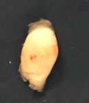
Maybe a sea peach?
This sea peach is a tan color here in the wet lab, but according to Bob, in its natural habitat it has a bright cherry red color.
Birthday party for Cheryl!
Well, it’s finally suppertime! That means “Birthday Party Time!” The ship’s chef, Harry served up a delicious meal of salmon, barbeque chicken, steamed kale, baked summer squash, scalloped potatoes and a big salad. For dessert, he prepared a layered chocolate cake with freshly made whipped cream and strawberries. Everyone sang “Happy Birthday” to Cheryl.
After she blew out the candles we went out on the deck and ate cake with new friends in the view of majestic mountains and glaciers.
A birthday to remember, I’ll say.
Now it’s back to work and the ROV crew is getting ready to deploy Kraken 2 for another night of exploration!
Scientists watch the ROV monitor
Anemone viewed on screen
Personal Log
Today has been a day of anticipation and inspiring wonder. I’ve tried to stay out on deck watching the glacier. Hoping for calving and avalanches. It’s really neat to me that no one else is here. We haven’t seen anyone else except four Park Service employees who boated out to meet us today. I found out that there are over 1,000 glaciers in Glacier Bay National Park! Some of them aren’t even named. I enjoyed watching a couple of bald eagles sitting on icebergs. And the absolute coolest thing has been the discovery of Primnoa pacifica in the West Arm of Glacier! I could feel the excitement in the air!
It’s so thrilling to be a part of this scientific exploration and to learn from these world-class researchers!
NOAA Teacher at Sea Mary Cook Onboard R/V Norseman II March 18-30, 2016
Mission: Deepwater Ecosystems of Glacier Bay National Park Geographical Area ofCruise: Glacier Bay, Alaska Date: Thursday, March 17, 2016
Introduction
Hello! My name is Mary Cook and I’m a science teacher in Scammon Bay, Alaska. Scammon Bay is a cozy little Yupik village nestled at the base of the Askinuk Mountains on the edge of the vast frozen tundra where the Kun River meets the Bering Sea. We live in what many people call Bush Alaska. It’s remote. We have no roads connecting our village to other places. Everything comes and goes mostly by small Bush planes. Barges bring supplies in the warmer months. We get around locally by snow-go, 4-wheeler, or boat.
Map of Alaska showing Scammon BayEntrance to Scammon Bay School
The Yupik Eskimo of Scammon Bay are traditionally fishers, bird hunters and trappers. Moose have also become an important food source over the last 20 years or so. Today they continue with this subsistence lifestyle blended with more modern conveniences such as cell phones and running water.
My students, co-workers and I are so excited to be involved with the NOAA Teacher at Sea program! Our school has been abuzz with preparations over the last few weeks.
Congratulations to our 4th graders for making a fantastic banner to take aboard the Research Vessel Norseman II! Also, thanks to many students who submitted names for our eagle mascot.
Scammon Bay 4th Graders with Vice Principal Harley Sundown (L), TAS Mary Cook, Principal Melissa Rivers, and 4th Grade Teacher Michele Benisek (R)
Drum roll……His name is Qanuk! (Qanuk means snowflake in the Yupik language.) I anticipate that he will make some mystery appearances around the ship in the coming days.
Stryofoam Cups decorated by Scammon Bay students
We have decorated and signed lots of Styrofoam cups to be sent to the bottom of the Bay. We are very curious about what will happen to our cups as they descend into the depths! We also can’t wait to find out more about the secrets of the Red Tree Coral, which is the focus of the research for this voyage into Glacier Bay.
Wednesday, I left my students in Scammon Bay as I boarded the small bush plane headed for Bethel. Then flew from Bethel to Anchorage and from Anchorage on to Juneau. It was a long day of flying and waiting and flying and waiting. But the late night flight into Juneau was worth it when, as we rose above the snow clouds, I peered out the window to see a magnificent aurora glowing in the sky!
Mary’s students wave goodbye
Aerial view of Scammon Bay Village
Yesterday I had a little bit of time to get out and see the sights of Juneau. My favorite was the Mendenhall Glacier. Wow! So beautiful and powerfully majestic in all its frozen splendor. In addition to the glacier, there are bald eagles perched in treetops all around town.
Where’s Qanuk?
Bald eagles (not just Qanuk!) are a common sight around Juneau
Last night I met many of the science crew and a few of the ship’s crew. What a positive and exciting group of people. Even they are excited about being part of the NOAA Teacher at Sea Program!
This is going to be fun—-and educational.
Don’t you just love that combination? Fun and educational.
Today we load the ship.
Tomorrow we sail away into the Bay.
NOAA Teacher at Sea
Theresa Paulsen
Aboard NOAA Ship Okeanos Explorer
March 16-April 3rd
Mission: Caribbean Exploration (mapping) Geographical Area of Cruise: Puerto Rico Trench Date: April 2, 2015
Weather Data from the Bridge: Partly Cloudy, 26 C, Wind speed 12 knots, Wave height 1-2ft, Swells 2-4ft.
Science and Technology Log:
What are the mappers up to?
After we completed our two priority areas of the cruise, the mappers have been using Knudson subbottom sonar to profile the bottom of the trench. Meme Lobecker, the expedition coordinator sends that data directly to the United States Geological Survey (USGS) for processing. They returned some interesting findings.
The subbottom sonar sends a loud “chirp” to the bottom. It penetrates the ocean floor. Different sediment layers reflect the sound differently so the variation and thickness of the layers can be observed. The chirp penetration depth varies with the sediments. Soft sediments can be penetrated more easily. In the picture below, provided by USGS, you can see hard intrusions with layers of sediments filling in spaces between.
The intrusions are basement relief, likely uplifting deformation ridges created by the subduction of the North American Plate. The subduction is now oblique, with the North American and Caribbean plates mostly sliding past each other now – sort of like the San Andreas Fault – but there is still some subduction happening. Subbottom Image and caption courtesy of USGS.
How does the bathymetry look?
In the last two days, I have been really enjoying the incredible details in the bathymetry data the multibeam sonar has gathered. We mapped over 15,000 square miles on our voyage! Using computer software we can now look at the ocean floor beneath us. I tried my hand at using Fledermaus software to make fly-over movies of the area we surveyed (or should I say swim-over movies). Check them out:
I also examined some of the backscatter data. In backscatter images soft surfaces are darker, meaning the signal return is weaker, and the hard surfaces are whiter due to stronger returns. One of the interns, Chelsea Wegner, studied the bathymetry and backscatter data for possible habitats for corals. She looked for steep slopes in the bathymetry and hard surfaces with the backscatter, since corals prefer those conditions.
On the next leg, the robotic vehicle on the ship will be used to examine some of the areas we were with high-definition cameras. You can watch the live stream here. You can also see some of the images and footage from past explorations here.
This is a short video from the 2012 expedition to the Gulf of Mexico to tempt you into tuning in for more.
Personal Log:
The people on this vessel have been blessed with adventurous spirits and exciting careers. Throughout the cruise, I heard about and then came to fully understand the difficulty of being away from family when they need us.
I would like to dedicate this last blog to my father, Tom Wichman. He passed away this morning at 80 years of age after battling more than his share of medical issues. As I rode the ship in today I felt him beside me. Together we watched the pelicans and the boobies fly by. I am very glad I was able to take him on a “virtual” adventure to the Caribbean. He loved the pictures and the blog. I thank the NOAA Teacher at Sea program for helping me make him proud one last time.
My Parents, Tom and Kate Wichman
“To know how to wonder is the first step of the mind toward discovery” – L. Pasteur. These words decorate my classroom wall but are epitomized by the work that the NOAA Okeanos Explorer and the Office of Exploration and Research (OER) do each day.
Thank you to the Meme, the CO, XO, the science team, and the entire crew aboard the Okeanos for teaching me as much as you did and for helping me get home when I needed to be with family. I wish you all the best as you continue to explore our vast oceans! My students and I will be watching and learning from you!
I would also like to thank all of the people who followed this blog. Your support and interest proves that you too are curious by nature. Life is much more interesting if you hold on to that sense of wonder, isn’t it?
Answers to My Previous Questions of the Day Polls:
1. Bathymetry is the study of ocean depths and submarine topography.
2. The deepest zone in the ocean is called the hadal zone, after Hades the Greek God of the underworld.
3. It takes the vessel 19 hours and 10 minutes to make enough water for 46 people each using 50 gallons per day if each of the two distillers makes 1 gallon per minute.
NOAA Teacher at Sea Theresa Paulsen Aboard NOAA Ship Okeanos Explorer March 16 – April 3, 2015
Mission: Caribbean Exploration (Mapping) Geographical Area of Cruise: Puerto Rico Trench Date: March 28, 2015
Weather Data from the Bridge: Scattered Clouds, 26˚C, Wind speed 13-18 knots, Wave height 5-7ft
Science and Technology Log
Mapping of our first priority area is now compete and we have moved to the priority two area on the north side of the Puerto Rico Trench. We are more than 100 miles from shore at this point. Land is nowhere in sight. Able-Bodied Seaman Ryan Loftus tells me that even from the bridge the horizon is only 6.4 nautical miles away due to the curvature of the earth. At this point with no frame of reference other than celestial bodies, navigation equipment becomes essential.
The ship uses Global Positioning Systems, GPS units:
GPS Units aboard the vessel
Radar:
The radar display.
On the radar display, we are in the center of the circle. Our heading is the blue line. Since this photo was taken near shore, the yellow patches on the bottom indicate the land mass, Puerto Rico. The two triangles with what look like vector lines to the left of us are approaching vessels. On the right, the Automated Identification System displays information about those vessels, including their name, type, heading and speed. The radar uses two radio beams, an S-Band at 3050 MHz and an X-band at 9410 MHz, to determine the location of the vessel relative to other vessels and landmarks within a 1% margin of error.
Gyrocompasses:
A gyrocompass
A standard compass points to the magnetic north pole rather than true north, therefore mariners prefer to use gyrocompasses for navigation. Before departing, a gyrocompass is pointed to true north. Using an electric current, the gyroscope in the device is spun very fast so that it will continually maintain that direction during the voyage. Slight errors build up over time and must be corrected. The watch standers post the necessary correction on the bridge. Since the device is electronic, it can feed data into the system allowing for automated navigation and dynamic positioning systems to work well.
The Electronic Chart Display Information System (ECDIIS) Screen
On the Electronic Chart Display Information System (ECDIS) screen, watchstanders can view the course planned by the Expedition Coordinator in charge of the science conducted on the voyage (in red), see the bearing they have set (thin black line), and see the actual course we are on (the black, dashed, arrowhead line).
The Dynamic Positioning System
The dynamic positioning system allows the vessel to remain in one spot in very delicate situations, such as when they lower a tethered device like the robotic vehicle they will be using on the next cruise or a CTD (Conductivity, Temperature and Depth probe). It is also helpful for docking.
The electronics are able to control the ship due to the ingenious way the engine system is designed. The diesel engine powers generators that convert the mechanical energy into electrical energy. This way electrical energy can be used to control main hydraulic propellers at the stern as well as electric bow and side thrusting propellers.
This slideshow requires JavaScript.
What happens if the power goes out and the electronic navigation devices fail? There are back ups – no worries, students and family!!
The vessel can sail onward. It is equipped with a magnetic compass and the watchstanders are well versed in reading charts, using a sextant, and plotting courses by hand – they often do that just to check the radar and GPS for accuracy.
The superimposed red arrow is directing your attention to the magnetic compass above the bridge.Operations Officer, Lt. Emily Rose cross checking the radar and GPS with nautical charts.Seaman Ryan Loftus teaching me how to use a sextant.
They also have a well-used copy of the “bible of navigation,” The American Practical Navigator written in 1802 by Nathaniel Bowditch.
The American Practical Navigator, The “Bible” of navigation for over 200 years.
They even let me take it for a spin – okay it was about a 90˚ turn – but hey, it feels pretty cool to be at the helm of a 224ft vessel!
Steady as she goes! Mrs. Paulsen’s at the helm!
So where are we right now?
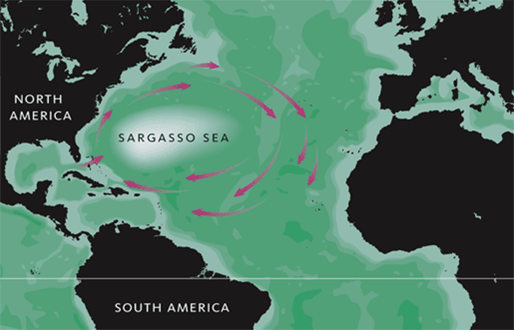
As I said we have begun mapping in our second priority zone, more than 100 miles north of Puerto Rico. We are near the boundary of the Sargasso Sea. It is not bordered by land, like other seas. Instead it is bordered by ocean currents that keep the surface water in one area.
The Sargasso Sea. Image Credit: US Fish and Wildlife Service
Remember the seaweed I wondered about in an earlier post? It is called Sargassum. It grows in rafts in the Sargasso Sea. This is actually where the Sargasso sea got its name. According to NOAA’s National Ocean Service, these rafts provide habitat for certain fish and marine life. Turtles use them as nurseries for their hatchlings. In recent years large blooms of Sargassum have been washing up on nearby coastlines causing problem along the shore. (Oct 1, 2014, USA Today) More research needed! There are always more questions. Is this caused by warming oceans, by oil spills, or by a combination? Nothing lives in isolation. All life forms are connected to each other and to our environment. Changes in the ocean impact us all, everywhere on the globe.
A Sargassum Mat. Photo courtesy of NOAA.
Want to explore yourself? Check out NOAA Corps to become ship officer!
Acting Executive Officer (XO) Lieutenant Fionna Matheson is augmenting on this leg of the trip, meaning she is filling in for the XO currently on leave. Otherwise, in her current “land job” she works at NOAA headquarters for the NOAA Administrator, Dr. Kathryn Sullivan. Dr. Sullivan, a former astronaut and the first American woman to walk in space, reports to the Secretary of Commerce, Penny Pritzker. Working on the headquarters team, LT Matheson learns a great deal about the breadth and importance of NOAA’s mission.
Lt. Fionna Matheson
To become a member of the NOAA Corps you must have a Bachelor’s degree in Science or Math. It is a competitive process, so some sort of experience with boating is advantageous, but not required. NOAA Corps officers are trained not only to drive and manage ships, but also to handle emergencies including fire-fighting, and follow maritime law. They act as the glue between the scientists and the crew (wage mariners), making sure the scientific mission is accomplished and the safety of the crew and the vessel are secure. Fionna has been part of the corps for 11 years. She explains that NOAA Corps officers are stationed for about 2 years at sea (with some shore leave) followed by 3 years on land throughout their careers. During her NOAA career, Fionna has sailed in the tropical Pacific maintaining deep-ocean buoys, fished in the North Atlantic, collected oceanographic samples in the Gulf of Mexico, and now mapped part of the Caribbean. She has also worked as part of an aerial survey team in San Diego, studying whales and dolphins.
Fionna’s advice to high school students is this, “The difference between who you are and who you want to be is action. Take the initial risk.”
Personal Log
What do we do for fun in our free time?
We read.
Jason Meyer, Mapping Watch Lead, reading on the Okeanos during his off hours.
We play games like chess, although I am not very good. I try, and that is what is important, right?
Chief Steward Dave Fare and CO Mark Wetzler playing a warm up game before the chess tournament.
We watch movies – even watched Star Trek on the fantail one evening. Very fitting since we are boldly going where no one has gone before with our high-resolution sonar.
Movie night on the fantail.
And we watch the sun go down on the ocean.
A view from the fantail of the ship.
Mostly, I like watching the water when I have time. I would have made a great lookout – I should look into it after I retire from teaching. I have been trying to use my Aquaman powers to summon the whales and dolphins, but so far – no luck. Maybe on the way back in to shore we’ll catch another glimpse.
What do I miss?
My family and friends. Hi Bryan, Ben, Laura, Dad, Mom, and the rest of the gang.
My family
And my students and coworkers. Go Ashland Oredockers!
Ashland Public Schools, Ashland, Wi
I am fortunate to have such supportive people behind me! Thanks, guys!
I do not miss snow and cold weather, so if you all could warm it up outside in northern Wisconsin over the next week, I’d appreciate it. I’ll see what kind of strings I can pull with these NOAA folks! ¡No me gusta la nieve o el frío en la primavera!
Did you know?
Sky conditions on the bridge are determined by oktas. An okta is 1/8th of the sky. If all oktas are free of clouds the sky is clear. If 1-2 oktas contain clouds, the bridge reports few clouds, 3-4 filled oktas equal scattered clouds, 5-7 equal broken clouds, and 8 filled oktas means the sky is overcast.