

NOAA Teacher at Sea
Dieuwertje “DJ” Kast
Aboard NOAA Ship Henry B. Bigelow
May 19 – June 3, 2015
Mission: Ecosystem Monitoring Survey
Geographical area of cruise: East Coast
Date: May 31, 2015
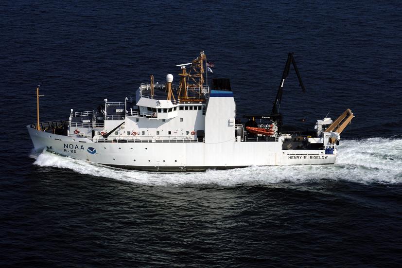
NOAA Ship Henry B. Bigelow
“National Oceanic and Atmospheric Administration (NOAA) Ship Henry B. Bigelow is the second of five new fisheries survey ships to be built by NOAA. The ship is named after Henry Bryant Bigelow (1879-1967), a Harvard-educated zoologist whose work helped lay the scholarly foundation for oceanography as a scientific discipline. He was an internationally known expert on the Gulf of Maine and its sea life, and on the world’s jellyfish, corals, and fishes” (NOAA NEFSC).
http://www.nefsc.noaa.gov/Bigelow/pdfs/bigelow_scientist_poster.pdf

Legacy of the name:
Henry B. Bigelow (1879–1967) was an American oceanographer and marine biologist. Bigelow described numerous new species to science, 110 of which are recognized today according to the World Register of Marine Species. In addition, some 26 species and two genera (Bigelowina, stomatopods in family Nannosquillidae, and Bigelowiella, protists in family Chlorarachniophyte) are named after him. The Henry Bryant Bigelow Medal in Oceanography is awarded by the Woods Hole Oceanographic Research Institute to honor “those who make significant inquiries into the phenomena of the sea”. Bigelow was the first recipient of the medal in 1960. He was honored by the naming of NOAA Ship Henry B. Bigelow.
Mission of the ship:
“NOAA ship Henry B. Bigelow will support NOAA’s mission to protect, restore, and manage the use of living marine, coastal, and ocean resources through ecosystem-based management. Its primary objective will be to study, monitor, and collect data on a wide range of sea life and ocean conditions, primarily in U.S. waters from Maine to North Carolina. The region includes Georges Bank, one of the world’s best known and most productive marine areas. The region is also home to the nation’s top-valued port, oldest commercial fisheries, and rare large whales and sea turtles. Data are used by a range of scientists who study variation in ocean conditions and sea life in order to better inform the nation’s decisions about both using and sustaining the ocean’s bounty.
“Henry B. Bigelow will also observe weather, sea state, and other environmental conditions, conduct habitat assessments, and survey marine mammal and marine bird populations. Henry B. Bigelow is a state-of-the-art research ship with multiple science mission capabilities. Foremost among these capabilities is the ship’s “quiet” hull, a design feature that minimizes sound made by the ship underwater. This allows scientists to use hydroacoustic methods for surveying marine life, and significantly reduces changes in the natural behavior of animals owing to the ship noise. In addition, the vessel can collect a variety of oceanographic data while marine life surveys are underway, resulting in both richer and more efficiently collected data.” (NOAA NEFSC)
Ship Details:

Take a virtual Ship Tour here! : http://www.nefsc.noaa.gov/Bigelow/shiptour.html
Levels: 2 (staterooms, gym, laundry), 1 (Mess Hall), 01 (Lounge), 02, Bridge, Flying Bridge

Most of the main deck is reserved for mission functions. The aft working deck provides 145 sq m of open space for fishing and other over-the-side operations, with an additional 33 sq m of deck space at the Side Sampling Station. Space and support connections are provided for a laboratory van on the aft working deck.
Large, easily reconfigurable laboratories are designed to accommodate the varied needs of individual scientific cruises:
- Fish/Wet Laboratory 56 sq m (602 sq ft)
- Chemistry Laboratory 27 sq m (290 sq ft)
- Dry Laboratory 14 sq m (150 sq ft)
- Hydrographic Laboratory 9 sq m (96 sq ft)
- Scientific Freezer 19 sq m (204 sq ft)
- Preservation Alcove 5 sq m (54 sq ft)
- Acoustic/Computer Laboratory 46 sq m (495 sq ft)
“Underwater radiated noise has been shown to influence fish behavior, and sonar self-noise can limit the effectiveness of hydroacoustic surveys and other functions. The International Council for Exploration of the Seas (ICES) has established a standard for ships’ underwater radiated noise in order to effectively employ hydroacoustic stock assessment techniques. Henry B. Bigelow has been designed and constructed to meet this ICES noise standard. This reduced noise signature will improve NOAA’s ability to accurately assess fish stocks and to compare standardized data with the international fisheries scientific community. Examples are the propulsion motors, which are specially constructed and balanced to reduce noise and vibration, and the diesel generators, which are mounted on double isolated raft systems. The hull form and highly skewed, five-bladed propeller were carefully designed and tested using U.S. Navy quieting techniques. Pumps, motors, ventilation and piping systems are all designed for low noise, with some critical systems resiliently mounted in the ship. Hull structure is treated in critical areas with special acoustic damping tiles. Airborne noise has been reduced throughout the ship for personnel safety and comfort.” http://www.omao.noaa.gov/publications/bigelow_final.pdf
To summarize that, this ship is so quiet I cannot tell when we are slowing down to 2 knots for bongo or going 11 knots to steam to the next station. It’s amazing.
Bridge:
The bridge is equipped with numerous dedicated systems including:
- Hydrographic ES60 SONAR system, and ME70 multibeam system
- Dynamic positioning and auto pilot system
- X- and S-band Sperry Bridge Master RADARs
- Transas ECDIS Navigation system
- DGPS receiver
- GMDSS communications suite including weather fax, satellite telephone, MF/HF and VHF radios
- MTN internet communications system
- SCS remote console and master clock display
- Doppler speed log and depth sounder
- Sperry primary and secondary gyro compass
Nearly all of these systems are solely controlled from the bridge, allowing scientific and operational systems to be totally independent. All scientific and fishing systems can be monitored from the bridge via remote consoles or SCS interfaces.


Cool Events on the Ship
Care Package Delivery:

Emergency Drills:
The Bigelow values safety and to make sure that everyone knows what to do in an emergency they do quiet a few surprise drills to keep everybody on their toes.

The first one was a Fire Drill and an Abandon Ship Drill on Wednesday May 20th, 2015.

Practicing the PLT gun (Pneumatic Line Throwing Gun): This is a gun that is used to help rescue people who have fallen overboard and it is also used to pass lines to other boats. It has a projectile connected to a long line that can travel far distance and connect an overboard victim to the boat.
Here is a video of it being shot:


Hydrophoning Acoustic Buoys!
While we were on the southern part of Georges Bank, the boat used a Hydrophone and geometry to pick up an Autonomous Multi-Channel Acoustic Recorder (AMAR) mooring in Lydonia Canyon. The ship sent signals to it with the hydrophone and the signals it received back were indications of where to send the boat next.


All of the crew have been absolutely amazing and have definitely made this the trip of a lifetime. Thank you all so much. -DJ


