
Jessie Soder: Geology on Georges, August 17, 2011

NOAA Teacher at Sea
Jessie Soder
Aboard NOAA Ship Delaware II
August 8 – 19, 2011 

Mission: Atlantic Surfclam and Ocean Quahog Survey
Geographical Area of Cruise:  Northern Atlantic
Date: Wednesday, August 17, 2011

Weather Data
Time: 12:00
Location:  41°19.095 N, 71°03.261
Air Temp:  22°C (°F)
Water Temp:  21°C (°F)
Wind Direction: South
Wind Speed: 7 knots
Sea Wave height:  0
Sea Swell:  0

Science and Technology Log
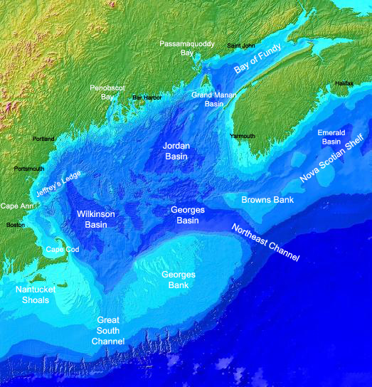
Gulf of Maine: Including Georges Bank

So far, we have spent this entire trip on Georges Bank.  This famous geographical location off the east coast of the United States is something that I had only heard about before this trip.  After several tows over the past week I have been able to see a variety of materials brought up from the ocean floor of Georges Bank.  I have seen loads of clams, empty shells, sand, mud and clay, and smooth polished rocks.  We have even pulled up a few boulders that must have weighed a couple of hundred pounds.  It was the smooth polished rocks that caught my attention. How would a rock from the bottom of the ocean become smooth and rounded?  It probably meant that Georges Bank must not have always been the bottom of the ocean.

During the Wisconsin Glaciation the ice reached its maximum around 18,000 years ago.  The Laurentide ice sheet paused in the area of Georges Bank and Cape Cod and left behind a recessional moraine that created these landforms.  This ice also had several meltwater streams flowing from it and these streams were responsible for the polishing the rocks and cutting some of the canyons found on the seafloor today.  The Northeast Channel off the northeast side of Georges Bank was the principle water gap for most of the meltwater.

Smooth Polished Rocks From the Ocean Floor

Georges Bank is a huge oval-shaped shoal bigger than Massachusetts that starts about 62 miles offshore.  It is part of the continental shelf and its shallowest areas are approximately 13 feet deep and its deepest areas 200 feet.  In fact, thousands of years ago Georges Bank used to be above water and an extension of Cape Cod.  About 14,000 years ago the sea rose enough to isolate this area and it was home to many prehistoric animals such as mastodons and giant sloths.  Today, traces of these animals are sometimes found in fishing nets!  These animals died out about 11,500 years ago when the sea level rose further and submerged the area.

Georges Bank is a very productive fishing area in the North Atlantic.  (The Grand Banks is more productive, but not as geographically accessible as Georges Banks.)  Why is Georges Bank a prime feeding and breeding area for cod, haddock, herring, flounder, lobsters, and clams?  It has to do with ocean currents.  Cold, nutrient rich water from the Labrador Current sweeps over the bank and mixes with warmer water from the Gulf Stream on the eastern edges of Georges Bank.  The mingling of these two currents, plus sunlight, creates an ideal environment for phytoplankton, which is food for the zooplankton.  In fact, the phytoplankton grow three times faster here than on any other continental shelf.  All of this plankton feeds the ecosystem of fish, birds, marine mammals, and shellfish that flourish on Georges Banks.

Personal Log

Yesterday we left Georges Bank for stations off the coast of Rhode Island.  After dark, I stepped out on the back deck and Jimmy pointed out the lights of Nantucket and Martha’s Vineyard.  We were in sight of land for the first time in a week.  It wasn’t long before people had their cell phones out and were making calls.

A few times during this trip I have thought about sailors in the past and how they would leave for months, and even years, at a time and not have contact with their families and loved ones until they returned.  I have had email contact this entire time, yet I am really excited to go home to see those that I miss.  I can hardly imagine what it would be like to be gone for a year with no contact at all.

Throughout this trip I have been getting to know others on this cruise.  I have learned that several of them have families and young children at home.  Many of them are at sea for many weeks, or months, a year.  After being on this cruise, I have gained a lot of respect for people who choose to work on the ocean for a living.  It takes a certain type of person who can work hard, maintain a positive attitude, and live away from their home and loved ones for extended periods of time.  It has been an honor to work with these people.

Anne Artz: August 2, 2011

NOAA Teacher at Sea
Anne Artz
Aboard NOAA Ship Delaware II
July 25 — August 5, 2011

Mission: Clam and Quahog Survey
Geographical Area: North Atlantic
Date: July 30, 2011

Weather Data from the Bridge
Location:  Georges Bank off the New England coast
Latitude: 42.634N
Longitude: 68 00.801 W
Conditions: Cloudy today, somewhat cooler but with sun most of the day

Science and Technology Log

This being the beginning of a new month we all did our safety drills on August 1 – that means everyone, including all the crew.  First we did the fire drill then the “Abandon ship” drill where we had to put on our “gumby” suits in one minute.  I did much better this time!  We’ve moved away from the New York-New Jersey coast and are now on the Southern Georges Bank.  We ran into a problem this morning when the cable that runs the pump for the dredge got tangled around the dredge during one of the drops.

A damaged power cable on the dredge

It necessitated cutting the cable that was twisted around the dredge then reconnecting it.  The cable itself is a series of copper wires twisted into 6 coils, surrounded by a neoprene “skin”, then surrounded by a Kevlar sleeve, and finally a synthetic woven casing.  It will take somewhere of 6-8 hours to repair the cable during which time we cannot do any dredging.  I’m going to use the down time to introduce you to some of the crew here on the Delaware II.

LCDR Richard Hester and ENS Carl Noblitt

There are three groups of workers: the NOAA Commissioned Corps which run the ship, the crew members who perform day-to-day work on board, and the science crew who are responsible for performing the scientific experiments for each expedition.  The NOAA Commissioned Corps on the Delaware II consists of the Commanding Officer (CO), LCDR Richard Hester, Executive Officer (XO), LCDR Sean Cimilluca, LT Fiona Matheson in charge of operations, ENS Shannon Hefferan, the Navigations Officer, and ENS Carl Noblitt, Junior Officer.

LCDR Sean Cimilluca

I interviewed Ensign Hefferan and asked her how she got into the NOAA  Commissioned Corps and what her job was like.  I’ll be posting that interview once we are back in Woods Hole since internet connections are not that good out at sea.

Personal Log

I would be remiss if I didn’t give credit to our outstanding cooks on the Delaware II.  Both of the men who work in the galley do an amazing job.  Other than the first day I haven’t made it for breakfast but lunch and dinner have been wonderful.

Top chefs Jonathan Rockwell and James White on the Delaware II

We’ve had everything from BBQ chicken, lasagna, a full turkey dinner, scallops, shrimp, and lots of different kinds of fish.  Besides all that, they cook vegetables that even my husband might eat and he won’t eat anything but a baked potato!  They feed all 30 of us every day and it’s a good thing we work so hard otherwise I’d definitely have to be dieting when I get home!

Kathleen Brown: Sea Science, June 11, 2011

NOAA Teacher at Sea
Kathleen Brown
Aboard R/V Hugh R. Sharp
June 7 – 18, 2011

Mission: Sea Scallop Survey
Geographical area of cruise: North Atlantic
Date: June 11, 2011

June 11, 2011

Weather Data from the Bridge
Time: 12:50 PM
Winds 12.9 KTs
Air Temperature: 11.94 C
Latitude 41 05.84N
Longitude 067 25.88 W

Science and Technology Log

Lowering the CTD
Lowering the CTD

Every third station along the journey, the crew takes a CTD reading. CTD stands for conductivity, temperature, and depth. Using a submersible set of probes, the characteristics of the ocean water are measured at set intervals, from the surface to the sea bottom, and then again from the sea bottom to the surface. Wynn, the marine technician, takes the time to explain to me that on this cruise the equipment is set to measure temperature, salinity, oxygen and phosphorescence. The probe is extremely heavy and must be lowered with a winch. The capability of the equipment is quite sophisticated and can take a water sample at any depth. A canister can be programmed to shut quickly, capturing approximately ten liters of water. The timing of the data collection process depends upon the depth of the water, but today it takes about five minutes. The data is collected for the NOAA team back on land.

Our journey will circle the outer edges of George’s Bank. We are on the eastern leg of the trip, somewhere between 80 and 100 miles from land. As far as the eye can see, it is ocean. Once in a while, we can see a fishing vessel off in the distance and we have seen dolphins and sunfish swimming near the ship. This afternoon I heard Mary, the First Mate, announce over the radio that she spotted a whale. I ran up to the bridge to see if I could get a look, but I was too late!

I have been eager to learn the stories of the scientists and crew, and to find out what has drawn them to the work at sea. The backgrounds of the people on the ship are varied, and they are both men and women of all ages. One person reports, “ I knew that I wanted to be a marine biologist since fifth grade.” Another says, “I grew up around boats.” Yet another speaks about wanting a hands-on career that could last a lifetime. There are several students on this leg of the cruise. I have learned there are many paths to the career at sea: experience in the military, technical school, college and university, and hands on experience over the years It seems that if you are attracted to the sea, you have a place on a scientific research vessel.

Personal Log
Toward the end of the day, the boat starts to roll a bit more than it has. We have been informed that the wave heights tomorrow may increase to 5 to 8 feet. Taking a shower while the boat rocks from side to side is challenging. I grip my flip flops to the floor of the shower and hang on!

Question of the Day
What do you think the level of salt in the water can tell scientists?

Marilyn Frydrych, September 23, 2008

NOAA Teacher at Sea
Marilyn Frydrych
Onboard NOAA Ship Delaware II
September 15-25, 2008

Mission: Atlantic Herring Hydroacoustic Survey
Geographical area of cruise: New England Coastal Waters
Date: September 23, 2008

Weather Data from the Bridge 
42.42 degrees N, 67.39 degrees W
Cloudy with wind out of the N at 32 knots
Dry Bulb Temperature: 15.5 degrees Celsius
Wet Bulb Temperature:  11.6 degrees Celsius
Waves: 6 feet
Visibility:  10 miles

Science and Technology Log 

Yesterday we were fairly busy doing CTD casts and trawls. Today we woke to find the night crew just starting to record the lengths and weights of their large catch. We grabbed some cereal and took over from them at 5:45 a.m. They had collected and sorted all the fish. Jacquie and I took about two hours measuring, weighing, and examining the innards of the half basket of herring they left us. Our chief scientist, Dr. Mike Jech, summarized his findings so far in a short report to everyone including those back at Woods Hole: “Trawl catches in the deeper water near Georges Bank have been nearly 100% herring with some silver hake.  Trawl catches in shallow water (<75 m) have occasionally caught herring, but mostly small silver hake, redfish, butterfish, and red hake.

A night haul of herring.  Notice the brilliant blue stripe on the top of the herring. The camera’s flash is spotlighted in the reflective tape on the life vests.
A night haul of herring. Notice the brilliant blue stripe on the top of the herring. The camera’s flash is spotlighted in the reflective tape on the life vests.

Small being less than 5-6 cm in length.  We caught one haddock this entire trip.  Trawl catches north of Georges Bank have been a mix of redfish and silver hake, with a few herring mixed in.” This afternoon the Officer of the Deck, LT(jg) Mark Frydrych, gave me a run down of many of the instruments on the bridge.  I spotted a white blob on the northeastern horizon and pointed it out. He showed me where it was on the SIMRAD FS900, a specialized radar.  The SIMRAD FS900is often able to identify a ship and its name.  This time it couldn’t.  Looking through binoculars we could see it was a large container vessel.  Then we looked at a different radar and saw both the ship’s absolute trajectory and its trajectory relative to the Delaware 2.  It was on a path parallel to the Delaware2 so Mark didn’t worry about it intersecting our path.  We also noticed another ship off to the west and north of us on the radar, but we couldn’t yet see it on the horizon. It too was projected on a path parallel to us.

Then Mark pointed out an area on the SIMRAD FS900 outlined in red. It’s an area where ships can voluntarily slow to 10 knots in an effort to avoid collisions with whales. It seems that sleeping right whales don’t respond to approaching noises made by ships.  There are only about 350 to 500 of them left and they are often killed by passing ships. The Delaware 2 was steaming at about 7 knots because in the 6 ft waves it couldn’t go any faster. However the container ship was steaming at 15.5 knots.  Few ships slow down in the red zone.

Mark showed me how to fill out the weather report for that hour.   I typed in all my info into a program on a monitor which assembled all my weather data into the format the weather service uses. I first recorded our position from an instrument displaying the latitude and longitude right there above the plotting table.  I read the pressure, the wet bulb temperature and the dry bulb temperature from an instrument which had a readout in a room off to the starboard of the bridge.  The ship has two anemometers so I averaged these to get the wind speed and direction.  We looked at the waves and tried to imagine standing in the trough of one and looking up.  I figured the wave would be over my head and so estimated about 6 feet.  We also looked at the white foam from a breaking wave and counted the seconds from when it appeared until it rode the next wave. The period of the wave we watched was four seconds.  Next we looked out the window to search out any clouds. It was clear in front of us but quite cloudy all behind us.  I estimated the height of the clouds. I typed all this information into the appropriate boxes on the monitor.  It was all so much easier than my college days when we had to gather the information manually then switch it by hand into the code appropriate for the weather service.  The OOD sent this information to NOAA Weather Service on the hour, every hour operations permitting.

Personal Log 

Though my son was instrumental in persuading me to apply for the Teacher-at-Sea position I haven’t seen much of him thus far.  He’s standing the 1 to 4 shift both afternoon and night.  When I’m free he seems to be sleeping.  We don’t even eat meals together.  That’s why I made a special trip to the bridge today to meet up with him during his watch.

Rebecca Bell, August 19, 2008

NOAA Teacher at Sea
Rebecca Bell
Onboard NOAA Ship Delaware II 
August 14-28, 2008

Mission: Ecosystems Monitoring Survey
Geographical Area: North Atlantic
Date: August 19, 2008

Weather Data from the Bridge 
Latitude: 4000.7 N Longitude: 6931.5
Sea Surface Temperature: 21.2 C
Depth: 114m

The Delaware’slatest cruise track has taken it from Woods Hole, MA, south past the Outerbanks of North Carolina, and then north again toward Georges Bank
The Delaware’s latest cruise track has taken it from Woods Hole, MA, south past the Outerbanks of North Carolina, and then north again toward Georges Bank

Science and Technology Log 

We are heading east out to sea, right now at 4005 N latitude, 6942 W longitude. (Pull out those atlases). We will begin a turn north towards Georges Bank. Georges Bank is a large elevated area of the sea floor which separates the Gulf of Maine from the Atlantic Ocean and is situated between Cape Cod, Massachusetts and Cape Sable Island, Nova Scotia. Georges Bank is (was) one of the most productive North Atlantic fisheries (Grand Banks being the most productive). “Legend has it that the first European sailors found cod so abundant that they could be scooped out of the water in baskets. Until the last decades of this century these banks were one of the world’s richest fishing grounds… (Source: AMNH web site below).

This map shows the location of Georges Bank and the underwater topography.

Northeastern fishery landings are valued at approximately $800 million dockside, of which a large proportion is produced on Georges Bank. Recently, scientists of the U.S. Geological Survey (USGS) and NOAA’s National Marine Fisheries Service (NMFS) have undertaken an effort to document direct interactions between physical environmental factors and the abundance and distribution of fishery species. (Source: USGS below). This means that the water chemistry, temperature and other factors affect how many fish there are, how many kinds of fish there are, and where they are. The article from USGS explains that the sea floor sediments that form Georges Bank came from the time when glaciers scoured the area. Since that time, sea level has risen, covering the glacial sediments, and tides and currents are eroding the bottom. When this erosion happens, small sediment particles are winnowed out by tides and currents leaving larger gravel-sized sediments on the floor. This kind of surface is good for scallop larvae and other small animals so they can settle on the bottom and not get buried by sand. Thus, the type of sediment on the ocean floor helps determine what kinds of animals can live there.

This map shows the continental U.S. Exclusive Economic Zones (EEZs).

Interestingly enough, politics and international relations have affected our trip to Georges Bank. We have been waiting for clearance through the U.S. State Department working with the Canadian government, to get permission to go into Canadian waters. As Wikipedia explains below, part of Georges Bank is “owned” by the U.S. and part is “owned” by Canada. Our route is to take us through the eastern part of Georges Bank, the part owned by Canada. Unfortunately, due to the speed of processing the request, we just this morning found out we got clearance to go there. If the request had been denied, we would have had to sail around the Exclusive Economic Zone (EEZ) to avoid Canadian waters. Fortunately, we are now good to go.

From Wikipedia: 

“During the 1960s and 1970s, oil exploration companies determined that the seafloor beneath Georges Bank possesses untold petroleum reserves. However, both Canada and the United States agreed to a moratorium on exploration and production activities in lieu of conservation of its waters for the fisheries.

The decision by Canada and the United States to declare an Exclusive Economic Zone (EEZ) of 200 nautical miles (370 km) in the late 1970s led to overlapping EEZ claims on Georges Bank and resulted in quickly deteriorating relations between fishermen from both countries who claimed the fishery resources for each respective nation. In recognition of the controversy, both nations agreed in 1979 to refer the question of maritime boundary delimitation to the International Court of Justice at The Hague in The Netherlands. Following five years of hearings and consultation, the IJC delivered its decision in 1984, which split the maritime boundary in the Gulf of Maine between both nations out to the 200 NM limit, giving the bulk of Georges Bank to the United States. Canada’s portion of the Gulf of Maine now includes the easternmost portion of Georges Bank.”

American Museum of Natural History http://www.amnh.org/sciencebulletins/biobulletin/biobulletin/story1208.html (easy to medium to read)

USGS http://pubs.usgs.gov/fs/georges-bank/ (more difficult to read) The map above is also from the USGS website.

Personal Log 

It’s been a very quiet day today. We had several station samples this morning. At the first one, around 6:30 a.m. one of the crew members spotted two whales. They were too far away to see what kind they were. I, unfortunately, was inside the ship at that time and missed it. However, we are heading north so maybe we will have a chance to see some.