Shelley Gordon: The Serengeti of the Sea, July 26, 2019

NOAA Teacher at Sea

Shelley Gordon

Aboard R/V Fulmar

July 19-26, 2019

Mission:  Applied California Current Ecosystem Studies Survey (ACCESS)

Geographic Area of Cruise:  Pacific Ocean, Northern and Central California Coast

Date:  July 26, 2019

My NOAA Teacher at Sea experience wrapped up yesterday with our 7th, and final, day of the cruise.  Our last day was another observation-only day where we travelled along two transects (lines 5 and 7) and recorded what could be seen from above the water.  I want to wrap up my experience by sharing some information about this observation technique and what I’ve learned about some of the living things we were able to observe on this trip. 

The Serengeti ecosystem in Eastern Africa is well known for its diversity of life and massive annual migrations.  On the wall of R/V Fulmar there is a large map of the three National Marine Sanctuaries (Cordell Bank, Greater Farallones, and Monterey Bay) off the coast of central California with the words “the Serengeti of the Sea” written at the bottom.  Like the Serengeti, the marine ecosystem in this area of the world supports a high diversity of life and intricate food webs.  Many of the species that thrive in these waters migrate from great distances, far greater than the well documented wildebeest migrations in Africa. 

A map of the protected areas off the central California coast.
Image from farallones.noaa.gov

The three National Marine Sanctuaries and adjacent state and federal parks protect a total of 10,676 square miles of habitat, helping to create a thriving ecosystem.  One thing that became clear to me on this cruise is that this is a massive amount of space!  To collect observation data, scientists sit on the flying bridge (or upper deck) and systematically record what they can see as the boat moves at a constant speed of ~10 knots along the transect.  Depending on the weather (we had days that were pretty foggy and other days that were overcast, but pretty clear), you can see several kilometers in any direction.  To complete an offshore observation line, it takes about 2.5 hours.  So, it is a full day to complete 2 observation lines, especially when you include the travel time to and from each line.  During that time, there are times when you can see very little other than wind-blown whitecaps on the surface of the water.  There are other times when there is a frenzy of activity.

(From left to right) Dani Lipski, Dru Delvin, Rachel Pound, Jaime Jahncke, Kirsten Lindquist, and Jan Roletto recording observation data from the flying bridge.

There are four roles is the observation data collection.  Sitting on the starboard side of the boat, Kirsten Lindquist’s job is to identify and describe all of the birds she observes within 200 meters of the side of the boat.  Some examples of “calls” she made include: “Common Murre, 3, zone 2, water” or “Western Gull, 1, zone 1, flying, 270°.”  To explain, she calls out the name of the bird, the number that she sees in the group, the relative distance they are from the boat (zone 1 or zone 2), and what they are doing (sitting on the water, flying, feeding, etc…).  This data is all recorded in the computer by Jaime Jahncke.  Dru Devlin and Jan Roletto (one on each side of the boat) are responsible for observing other things on the surface, including animals, boats, fishing gear, trash, kelp, etc…  An example of a call they relay to Jaime to record is:  “First cue blow, by eye, bearing 270°, reticle 5, observer 9, side 1, traveling, humpback whale, 2, 3, 2.”  There is a lot going on in this data, but it basically explains the observer has seen a group of humpback whales in the distance off the front of the boat (bearing 0°).  The group is swimming along the surface and the size of the group is between 2-3 individuals.  The observers use reticle markings, fine lines in the eyepiece of binoculars, to estimate how far the object is from the boat (reticle 14 is at the boat, reticle 0 is on the horizon).  Using the bearing and reticle numbers, the computer then can use the GPS location of the boat to estimate where that animal was at the time of the recorded observation.  Using all of this data collected over the course of time, scientists are able to put together a picture of where animals, birds, and other objects are frequently seen within the sanctuaries.  This can also help them identify changes in animal numbers or behavior, and/or the need for a change in management strategies.

An example of a map showing humpback whale observation data on ACCESS in 2018.
Image: Point Blue/ONMS/ACCESS

One of the seabird species we saw relatively frequently were Sooty Shearwaters.  These birds are interesting to me because the migrate to the sanctuaries from their breeding grounds in New Zealand, an amazing 6500 miles away!  What’s even more impressive is that their migration is not just from New Zealand to California; they actually complete a circular migration route, first traveling up the western Pacific toward Japan and the Artic, and then they drop down to the pacific coast of North America before returning to their breeding grounds in New Zealand.  We also observed Pink-Footed Shearwaters, which nest off the coast of Chile. 

Sooty Shearwaters taking off from the surface of the water.  Photo:  Dru Devlin

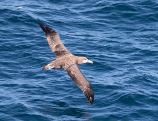
When we were out on the offshore transects beyond the continental shelf break, we were frequently able to observe Black-Footed Albatrosses.  These large seabirds are well known for their long migrations as well.  The population we observed in the sanctuaries nest in the Hawaiian Islands and visit the California coast to feed.  From dissecting Albatross boluses (regurgitated food) with students at Roosevelt, I had previously learned that their diet consists of a lot of squid.  Since squid are actively feeding at night, albatross also do a lot of their hunting at night.  I was curious how they could find their prey and I learned that they have an incredible sense of smell that they can use to detect food.  They are known to follow ships and feed on refuse in the wake, and this seemed to be apparent because when we were collecting samples at stations beyond the shelf break we were often joined by multiple albatrosses.  At one station, I counted 19 Black-Footed Albatrosses floating in a group near the boat.

Two Black-Footed Albatrosses near the boat. Photo: Dru Devlin
A Black-Footed Albatross in flight.
Photo: Dru Devlin

I was also very interested to learn about the way that albatrosses and other large seabirds (including shearwaters) conserve energy during their long flights.  Dynamic soaring allows them to gain energy from the wind above the ocean waves without flapping their wings.  We often observed these birds flapping their wings a few times and then soaring very close to the surface of the water before flapping again.  Apparently, in favorable wind conditions, these birds can us this method to fly great distances without flapping their wings at all, thus conserving energy.

Three humpback whales surfacing. Photo: Dru Devlin

Another animal that I was on the constant lookout for were whales.  These gigantic mammals have always captured my imagination.  On this cruise we were lucky enough to see quite a few humpback whales.  These large baleen whales are known for their acrobatic displays, occasionally launching their body out of the water in an action called breaching.  I was able to observe a few whales breaching, and also several instances of whales rolling on the surface of the water slapping their long flippers or tail at the surface.  One of the highlights was seeing humpbacks lunge feeding at the surface.  Lunge feeding is when the whale opens its mouth widely, engulfing a large amount to water and prey.  The whale then pushes the water out of its throat pouch, leaving the prey behind to consume.  One of the favorite foods of humpback whales is krill.  Using the Tucker trawl net at very deep depths, we were able to collect some large krill samples that will be analyzed back at the lab. 

There are several other species of whales that can be present in the sanctuaries at different times throughout the year, including blue whales, gray whales, fin whales, and minke whales, but we did not positively identify any of those species on this trip.  The scientists on board were specifically surprised that we did not see any blue whales, as they usually observe a few on cruises at this time of year.

Gallery

Here are a few other images of animals that we saw and were able to capture in the camera lens.

Did You Know?

Scientists can use robots to explore the undersea environment?  From October 3rd-11th, scientists from the Greater Farallones and Cordell Bank National Marine Sanctuaries will be partnering with the Ocean Exploration Trust to learn more about life beneath the waves.  Working aboard the Exploration Vessel (E/V) Nautilius, the team will use remotely operated vehicles (ROVs) to explore deep-sea coral reef and sponge habitats.  And, we will be able to follow along live

Shelley Gordon: ACCESS Partnership, July 24, 2019

NOAA Teacher at Sea

Shelley Gordon

Aboard R/V Fulmar

July 19-27, 2019


Mission:  Applied California Current Ecosystem Studies Survey (ACCESS)

Geographic Area of Cruise:  Pacific Ocean, Northern and Central California Coast

Date:  July 24, 2019


Applied California Current Ecosystem Studies (ACCESS) is a joint research project conducted by NOAA (Cordell Bank National Marine Sanctuary and Greater Farallones National Marine Sanctuary) and Point Blue Conservation Science. 

NOAA’s Office of National Marine Sanctuaries manages 13 sanctuaries and two marine national monuments, protecting a total of 600,000 square miles of marine and Great Lakes waters within the United States.  Four of the sanctuaries are in California.  Greater Farallones National Marine Sanctuary (GFNMS) is a large sanctuary that protects over 3,000 square miles of California coast and offshore marine habitat from San Francisco to Point Arena.  There are numerous beaches and costal habitats included in this sanctuary, as well as the Farallon Islands.  Cordell Bank National Marine Sanctuary (CBNMS) is a smaller sanctuary around Cordell Bank, a large offshore seamount approximately 22 miles from the coast.  Sitting at the edge of the continental shelf, Cordell Bank is approximately 26 square miles in size, and while you cannot tell it is there from the surface, it supports a huge diversity of brightly colored sponges, corals, anemones, and other invertebrates.  Both sanctuaries protect a wide variety of living organisms across the food chain, from phytoplankton to blue whales.

Cordell Bank and Greater Farallones NMS
Map of Cordell Bank and Greater Farallones National Marine Sanctuaries. Map taken from cordellbank.noaa.gov

Point Blue Conservation Science is a non-profit organization that is working to combat climate change, habitat loss, and other environmental threats by helping to develop solutions that benefit wildlife and people.  They work with local natural resource managers (like National Marine Sanctuaries) to help monitor and improve the health of the planet. 

Scientists from each of these organizations have come together to work on ACCESS.  This project, started back in 2004, collects data on the physical conditions and living things within GFNMS and CBNMS.  Scientists use this data to document wildlife abundance, monitor changes over time, and help inform decisions about conservation efforts.  For example, data collected on the location of whales can help create policies to reduce threats to whales, like ship strikes and entanglements.   There are many huge ships that come in and out of San Francisco Bay on a daily basis.  Scientists are currently working with the industry to support a reduction in ship speed, which can reduce the likelihood of whales coming into dangerous contact with ship hulls.  Another threat to whales are entanglement in fishing gear.  Legal commercial crab fishing using crab pots occurs within the sanctuaries.  In recent years there have been greater incidents of whales being entangled in the buoy lines that fisherman use to help them collect the crab pots from the bottom of the ocean.  As the result of a recent lawsuit filed by ­­­­­the Center for Biological Diversity, the commercial crab season ended early this year to try to help protect the whales.

Adult Common Murre
Adult Common Murre. Photo: Dru Devlin

An interesting, and possibly concerning, phenomenon is being observed on our cruise.  Kirsten Lindquist, the seabird expert on this cruise, has seen a great number of Common Murres on the water during our data collection observations.  However, she has noticed a lack of chicks.  Common Murres nest on rocky outcroppings and the chicks leave the nest 15-25 days after they hatch, before they are able to fly.  The chicks then float on the water are fed by their parents for several weeks until they can feed themselves.  Generally, at this time of year she would expect to see a large number of adult and chick pairings floating on the surface of the water together.  Today we saw quite a few chicks floating with an adult, but this has not been the case during the other days on this cruise.  It is unclear why there are fewer Common Murre chicks than are typically seen.

Did You Know?

Dani and Shelley deploy CTD
Dani Lipski and me deploying the CTD, a device used to measure water conductivity, temperature, and depth. Photo: Jaime Jahncke

Scientists use “conductivity” as a measure of how salty the ocean water is.  If the water is relatively cold and salty that is a sign of “good” upwelling conditions, meaning that the cold water from the deep ocean is moving up over the continental shelf, bringing a high concentration of nutrients with it.  The upwelling along the California coast is a main reason why there is such a diversity of ocean life here.

Shelley Gordon: T minus 2 (days)…, July 17, 2019

NOAA Teacher at Sea

Shelley Gordon

Aboard R/V Fulmar

July 19-27, 2019


Mission:  Applied California Current Ecosystem Studies (ACCESS)

Geographic Area of Cruise:  Pacific Ocean, Northern and Central California Coast

Date:  July 17, 2019

Science Log

This year my summer is coming to an end with a bang!  Tomorrow I will drive over to Sausalito, California to join a team of scientists on a research cruise as a NOAA Teacher at Sea.  Over the course of the next week I will be on the deck of R/V Fulmar, a NOAA research vessel, off the coast of California in the Cordell Bank and Greater Farallones National Marine Sanctuaries.  From what I have learned so far, this high nutrient area of the ocean attracts a lot of different forms of life.  Whales, dolphins, sea turtles, and a wide variety of sea birds all migrate to this region to feed on the many forms of prey that thrive here.  

Migration Map
A sample of some of the animals that migrate to Cordell Bank National Marine Sanctuary

Scientific data collected on this trip will contribute to the Applied California Current Ecosystem Studies (ACCESS), a long-term research project which started back in 2004.  This unique project is studying the offshore ecosystem in two National Marine Sanctuaries, Cordell Bank and Greater Farallones.  Three times each year scientists systematically collect data, and the resulting dataset shows how the ocean environment is changing over time, and how various populations of organisms are responding.  The data also helps scientists understand how to better protect the National Marine Sanctuary ecosystems (learn more at www.accessoceans.org).

ACCESS data collection
ACCESS data collection, boat-based transects

Over the course of our 8-day cruise, scientists on the ship will collect data along 11 transects (according to the plans, we will not be collecting data on transects 8-10 on this map).  As the ship moves along each transect, various types of data will be recorded, including counts of what can be seen above water (birds, marine mammals, ships, and marine debris like trash, fishing gear, etc…) and what is underneath the surface (plankton, krill, fish, and nutrients).  In addition, we will collect data on ocean salinity, temperature, and acidity.   I can’t wait to share information about what I see and learn on this adventure.

Personal Log

My interest in joining this research trip is both personal and professional.  I grew up with family members that are keen observers of nature.  My dad is an avid bird watcher who diligently kept a life list and my mom finds great pleasure in observing and identifying flowers and plants.  While I can appreciate these interests, the environment under the ocean waves is what has always captivated my attention.  Although I grew up in the desert of Tucson, AZ, I had the opportunity to learn how to SCUBA dive from a high school teacher and I have been hooked on learning about the animals in the ocean ever since.  My personal favorites are Giant Manta Rays and Harlequin Shrimp.  The opportunity to briefly step into the shoes of a marine scientist is something I am really looking forward to.

Shelley and her mom
At the Arctic Ocean on a recent trip to Iceland with my mom

I work at Roosevelt Middle School in Oakland, CA, a public school that serves a uniquely diverse population (in any given year we have more than 20 different home languages spoken by our students and their families).  As an educator in this amazing place I aim to support our students in growing their personal skills so that they can become the creative leaders our community will need in the future.  While the marine sanctuaries I will be visiting on this trip are practically in our backyard, they can also seem a world away from daily life in Oakland.  Yet, our daily lives have a huge impact on the ocean environment.  By participating as a NOAA Teacher at Sea on the ACCESS cruise, I am excited to gain first-hand research experience in my “backyard” and be inspired with new ways to help make this information come to life in our classrooms.

Students observe seals
Aaliyah and Mohamad observe harbor seals at Salt Point State Park
Students collect barnacle data
Roosevelt Middle School 6th graders collect barnacle data at Point Pinole Regional Shoreline

Over the next week I will happily share what we are up to on the boat.  I would also love to bring questions to the research team, so please send any you have my way! 


Did You Know? 

Balloons are the most common type of trash spotted from the research boat!  Helium-filled balloons easily wriggle out of the hands or knots meant to hold them down and float high into the sky.  I’ve watched many a balloon do just that and wondered, what happens to those balloons once they are out of sight?  Convection currents in the air eventually deposit those same balloons into the ocean, where they become dangerous hazards.  Marine animals can eat the balloons by mistake and die.  Hopefully we’ll see way more whales than balloons on this trip!?!  Stay tuned…

Pam Schaffer: Back on Dry Land- a Reflection, July 14, 2017

NOAA Teacher at Sea

Pam Schaffer

Aboard NOAA Ship Bell M. Shimada

[July 2-10, 2018]

Mission: ACCESS Cruise

Geographic Area of Cruise: North Pacific:  Greater Farallones National Marine Sanctuary, Cordell Bank National Marine Sanctuary

Photo of Pam Schaffer wearing hard hat
Pam Schaffer, NOAA Teacher at Sea

All I can say about my NOAA Teacher at Sea experience is WOW- what an incredible experience.   Thank you to everyone at the NOAA Teacher at Sea program, the crew of the NOAA Ship Bell M. Shimada, the ACCESS research scientists on-board and the staff of the Greater Farallones and Cordell Bank National Marine Sanctuaries.     I’d particularly like to thank Dr. Jaime Jahncke for teaching me how to collect and process zooplanton samples using the Tucker Trawler and enabling me to become a trusted member of his research team.

During the cruise, I learned so much about the work of oceanographers, marine biologists and ecologists.  I’ve sailed in these waters in my own sail boat many times but I’ve never seen the sanctuaries through the lens of a researcher.  The care and attention to detail taken during marine wildlife observations and the collection of  zooplankton and phytoplankton samples throughout the water column reveals an incredibly rich and abundant ecosystem.  The data collected will be shared with scientists around the world and helps us better understand and manage the health of our oceans.

The experience has given me lots of great ideas for lessons that I think will engage students and get them excited about knowing more about the ocean. I can hardly wait for the next school year to start so that I can share this amazing experience with students and facilitate learning experiences to inspire future scientists.

Here are some great wildlife pictures that I wanted to share earlier but the connectivity on the vessel was really limited and I wasn’t able to post them.

Humpback whale tail
Humpback Whale Tail. Photo credit: Julie Chase/NOAA/ACCESS/Point BLUE

humpback whale fin
Hump back Whale Fin. Photo Credit: Dru Devlin/NOAA/ACCESS/Point Blue

Pacific White-Sided Dolphin
Pacific White-sided Dolphin. Photo Credit: Dru Devlin/NOAA/ACCESS/Point Blue

Black Footed Albatross
Black Footed Albatross. Photo Credit: Julie Chase/NOAA/ACCESS/Point Blue

squid
Squid. Photo Credit: Ryan Anderson/NOAA/ACCESS/Point Blue

nazca boobie
Nazca Boobie- from the Galapagos. Photo Credit: Julie Chase/NOAA/ACCESS/Point Blue

sooty shearwater
Sooty Shearwater. Photo Credit: Julie Chase/ NOAA/ACCESS/Point Blue

Pam Schaffer: Welcome Aboard NOAA Ship Bell M. Shimada, July 2, 2018

NOAA Teacher at Sea

Pam Schaffer

Aboard NOAA ship Bell M. Shimada

July 2, 2018 – July 10, 2018


Today begins a nine day NOAA research cruise on NOAA ship Bell M. Shimada.  Presently, we’re docked in San Francisco and will head out the gate at 0900 tomorrow.   I’m  really excited to be part of a team of 12 scientists and specialists conducting research in the Greater Farallones and Cordell Bank National Marine Sanctuaries.  I plan to blog often (connectivity permitting) throughout the journey and to share the details of our work.

NOAA-Ship-Bell-M.-Shimada-underway_Photo-courtesy-NOAA
NOAA Ship Bell M. Shimada (photo credit: NOAA)

A bit about the ship-  NOAA ship Bell M Shimada was commissioned by NOAA in 2010.   Her home Port is Newport Oregon, and she supports research activities on the West Coast of the United States.   She’s 209 feet long and weighs 2479 tons, has a cruising range of 13,800 miles and travels at 11 knots (12.6 mph).  Shimada is an impressive vessel and is uniquely capable of conducting fisheries, oceanographic research and hydrographic studies.  She is considered to be one of the most advanced fisheries research vessels in the world.   Her stern looks very similar to a commercial fishing vessel and is capable of deploying large trawling nets for research to depths of 3,500 meters (11,483 feet).   Shimada uses specialized acoustic quieting technology developed by the U.S. Navy to monitor fish populations without disturbing the fish and altering their behavior.  She also has a Scientific Sonar System, used to measure the biomass of fish populations in a survey area.  Her acoustic profiling system enables scientists to gather data on ocean currents and provides information on the content of the water column and the topography of the seafloor.  In addition to sending out smaller sampling nets, longlines, and fish traps she can also deploy instruments to measure the electrical conductivity (used to determine salinity), temperature, depth (CTD) and chlorophyll fluorescence of sea water.  You can learn more about the ship here: https://www.omao.noaa.gov/learn/marine-operations/ships/bell-m-shimada/about

It’s a delight and an honor to be part of the ACCESS research team on NOAA ship Bell M. Shimada.


Dana Chu: Introduction, May 12, 2016

NOAA Teacher at Sea
Dana Chu
(Almost) Aboard NOAA Ship Bell M. Shimada
May 13-22, 2016

Mission: Applied California Current Ecosystem Studies (ACCESS) is a working partnership between Cordell Bank National Marine Sanctuary, Greater Farallones National Marine Sanctuary, and Point Blue Conservation Science to survey the oceanographic conditions that influence and drive the availability of prey species (i.e., krill) to predators (i.e., marine mammals and sea birds).

Geographical area of cruise:  Greater Farallones, Cordell Bank, and Monterey Bay National Marine Sanctuaries (all off the coast of California)

Date:  Thursday, May 12, 2016

Personal Log

TAS Dana Chu profile picHello from Sacramento, California! My name is Dana Chu and I am a Math and Science teacher and an Education Specialist at Florin High School.   This year I also teach a class called Multiple Strategies for Academics and Transitions and support a Spanish 1 class.   Florin High School has a diverse population of over 1,400 students that speak nineteen different languages. After school, I serve as an advisor to the Florin High School Watershed Team which is composed of students from all grade levels.

TAS Dana Chu watershed team
Florin HS Watershed Team at the American River Clean Up, September 2015

I am a firm believer that providing students with the opportunity to gain first-hand experience in wildlife areas and natural habitats is the key to inspiring them to become responsible stewards of their environment, both land and water. Our school is within walking distance of several local creeks. The Cosumnes River Preserve and the Yolo Bypass Wildlife Area, both of which serve as protected habitat and crucial feeding ground for migrating birds, are a short drive away.   We are also fortunate to be close to the American River where anadromous fish such as the Chinook salmon and Steelhead trout spawn. Salmon fry raised in the classroom through the Fish in the Classroom Program from Nimbus Fish Hatchery will be released there. Throughout the year, some of our students participate on field trips to these locations.   I can’t wait to share my Teacher at Sea experience with all of my students, especially because the water from our local creek and rivers eventually all feed into the ocean.

TAS Dana Chu watching sandhill cranes
Students from the Watershed Team watch Sandhill Cranes fly in to roost for the evening. This field trip was made possible by the Save Our Sandhill Cranes non-profit organization.

I applied for the NOAA Teacher at Sea program because I am very interested in sea turtles, ocean plastic pollution, and birds. I love being out on water whenever the opportunity arises and taking photographs of nature. I also want to learn from and directly work with scientists in the field. Having never traveled in the ocean for an extended period of time before, this research trip is a unique and exciting learning opportunity and chance for me to engage in many first-hand experiences. With ocean plastic pollution being a serious issue, I wonder what we will come across during the days while I am at sea. I can’t wait to sail out on the NOAA Ship Bell Shimada and to assist with scientific research in the Pacific Ocean! For more specific details on this expedition, please check the links for the Ship and the Mission.

TAS Dana Chu kayaking
This is a photo of me kayaking in Costa Rica in 2014.

In the meantime, I am in the midst of preparing for my upcoming scientific adventure. I am packing the last items needed for this research trip.   At school, the 9th graders are finishing up the Water and Ocean unit with a marine animal research project. I hope to bring back relevant information to share. My 11th graders are working on their career transition portfolios and mock job interviews. I look forward to learning about the different types of scientific and marine careers available from the members of this research cruise so I can inform my students of other potential careers they might have not considered.

When you hear from me next, I will have sailed out of San Francisco, California and experienced my first days of working and living at sea. I look forward to seeing the various pelagic birds plus marine mammals and invertebrates within their natural habitat. I am so excited to be part of this expedition!


Kate Trimlett: What a Difference 3 Days at Sea Makes, July 25, 2013

NOAA Teacher at Sea
Kate Trimlett
Aboard R/V Fulmar
July 23–29, 2013

Mission: ACCESS (Applied California Current Ecosystem Studies) to monitor ecosystem health in the national marine sanctuaries off the central and northern California

Geographical area of cruiseGulf of the Farallones Marine Sanctuary & Cordell Bank National Marine Sanctuary

Date: Friday, July 26, 2013

Weather Data:

  • Wind Speed: 7.8 kts
  • Surface Water Temperature: 58.3 Degrees Fahrenheit
  • Air Temperature: 55.4 Degrees Fahrenheit
  • Relative Humidity: 90%
  • Barometric Pressure: 30.05 in

Science and Technology Log:

ACCESS is a project that contributes to a regional characterization and monitoring of the physical and biological components of the pelagic ecosystem of Cordell Bank, Gulf of the Farallones, and northern Monterey Bay National Marine Sanctuaries.  During our cruise we are collecting data in these sanctuaries. Over the last three days I have observed and helped the ACCESS scientists collect physical, chemical, and biological properties of the water, plankton, marine mammals, and sea birds. Each of these are measured by a different ACCESS team of researchers in a different area of the research vessel, R/V Fulmar.

Plankton and water are collected and measured on the back deck of the ship.  The water is measured in a few ways.  First, a CTD (conductivity, temperature, and depth) and Niskin are lowered into the water between 35- 200 meters depending on the location on the line and depth of the water. The CTD measures the conductivity to calculate salinity, temperature, and relative depth within the water column.  The Niskin collects a water sample at the same location as the CTD.  These water samples are to tested for pH to measure the acidity of the water.  Finally, Dru Devlin and I are collecting a surface water sample for nutrients and a phytoplankton samples for the California Department of Public Health, as part of an early warning program for harmful algal blooms that can impact the shellfish we eat.

This CTD measure conductivity (salinity), temperature, and depth.
This CTD measures conductivity (salinity), temperature, and depth.

There are four different plankton collections.  The first collection is with a small hoop net (0.5 meter diameter) used to sample very small plankton, from where foraminifera will be separated later in the lab.  Foraminifera shell morphology and the oxygen isotopes of the shell are examined to investigate past and present climates and impacts of acidity on shell formation.  Next, a larger hoop net (1 meter diameter) collects samples of plankton in the upper 50 m of the water, which will be used to investigate the abundance, species, reproductive patterns, and locations.  When the research vessel was close to the end of the line and the continental shelf, the Tucker Trawl was released to collect three samples of plankton near the bottom.  When we processed these samples the majority of the organisms were krill.  Finally, Dru Devlin and I collected plankton samples 30 feet below the surface to send to the California Department of Health Services because they are interested in the presence and abundance of species that produce toxins.

Tucker trawl collects krill at depth.

On the top deck, the ACCESS observers watch for marine mammals and sea birds and call them out to the data recorder  to log the sightings into a waterproof computer.  This data will be used to relate the spatial patterns of bird and mammal distribution with oceanographic patterns and to understand the seasonal changes in the pelagic ecosystem.

These are the ACCESS observers looking for marine mammals and sea birds.

Personal Log:

My favorite sighting so far was the leatherback sea turtle.  Seven years ago and last summer I took a group of Berkeley High School students to Costa Rica to participate in a sea turtle conservation project with Ecology Project International.  On these trips we saw a female leatherback laying her eggs and a hatchling making its way to the ocean.  It was great to see the next stage of development when the leatherback popped its head out of the water several hundred miles from their breeding grounds.

Dru Devlin's amazing picture of the Leatherback Sea Turtle.
Dru Devlin’s amazing picture of the Leatherback Sea Turtle.

Did you know?

Humpback Whales have bad breath?  Yesterday we got to smell it first hand when two humpback whales decided to circle our boat and were close enough for us to smell their breath.  It’s like rotting fish and sour milk mixed together.

Talia Romito: First Day at Sea, July 23 – 24, 2012

NOAA Teacher at Sea
Talia Romito
Onboard R/V Fulmar
July 24– July 29, 2012

Mission: Ecosystem Survey
Geographic area of cruise: Cordell Bank and Gulf of the Farallones National Marine Sanctuaries
Date: July 23 & 24, 2012

Location Data:
Latitude: 37 48.87 W
Longitude: 123 23.04 N

Weather Data From Bridge:
Air Temperature 12.2 C (54 F)
Wind Speed 10 knots
Wind Direction: From the South
Surface Water Temperature: 13 C (55.4 F)

Personal Log

Day 1, July 23, 2012

Wow! I have been preparing for this day for months and now I’m here.  This is the adventure of a lifetime.  I’m so excited to tell everyone about everything that I’ve done so far and I’ve only been on board for two days.

Travel and Arrival

Me and Dad at Lunch
Me and Dad at Lunch, Picture by Karen Romito

I set off early Monday July 23, 2012 for the boat docked in Sausalito from my parents’ home near Sacramento, CA.  I’m fortunate to have my parents give me a ride so I don’t have to worry about leaving my car parked overnight.  We got into San Francisco at lunchtime and decided to stop at the Franciscan Restaurant near Fisherman’s Wharf.  The food was incredible and both Mom and Dad filled their cravings for bread bowls with clam chowder. Yummy!  We had an amazing view across the bay to Sausalito.  Next we headed for downtown Sausalito for dessert.  (If you haven’t gotten the clue yet this trip is all about great food and making friends.) It was beautiful with lots of little places to lose yourself and enjoy the view and watch people walking or riding by.  Cafe Tutti was a great little place for three waffle cones, laughs, and picturesque memories.  Then it was time to head to the boat!

Boat Tour and Unpacking

Permission to come Aboard?
Permission to come Aboard?, Picture by Karen Romito

I met Kaitlin Graiff and Erik Larson on board when I arrived.  She is the (Acting) Research Coordinator for the Cordell Bank National Marine Sanctuary and he is the Captain of the R/V Fulmar.  They were both so welcoming and gave us all the grand tour.  It only consisted of about fifty steps, but who’s counting.  We saw the wheelhouse (where you drive the boat), the bunk rooms (where you sleep on the boat), the galley (where you eat on the boat), the head (where you handle business on the boat), the fly bridge (where you observe animals), and the rear deck (where you use equipment to study the ocean).  I know that’s lots to remember, but it’s smaller than it sounds with cozy little places to have a snack or a cat nap.  Before I said my goodbyes Mom made me take a picture with all of my gear.  Thanks Mom!

Then it was time to unpack.  I chose the top bunk on the starboard side of the boat.  Now the important thing to remember is to duck when you get the top bunk.  There is almost no head room so duck early and often.  I’ve hit my head three times already.

Scientists Arrive

While Kaitlin, Erik, and I were getting to know each other, two more scientists arrived throughout the evening before dinner.  They were bringing the two most important parts of our cruise: the food and the equipment.  Jaime Jahncke, California Current Director for PRBO Conservation Science arrived first.  His name and title sound very official, but he is the most charismatic person you’ll meet.  He loves to joke around and have a good time while working to preserve and manage wildlife.  Last to arrive Monday night was Jan Roletto, Research Coordinator at Gulf of the Farallones National Marine Sanctuary.  Jan is the lead scientist on the cruise, mother hen to everyone.  She brought the most important thing for the trip: FOOD.  We have chips, nuts, crackers, chocolate covered everything, every soda drink imaginable, and more!  Did I mention that this trip is all about the food :).

Jan Roletto, Jaime Jahncke, and Kirsten Lindquist
The Scientists and Observer:
Jan Roletto, Jaime Jahncke, and Kirsten Lindquist

Day 2, July 24, 2012

Early Risers

Survival Suit
Me in Survival Suit during Safety Drill

I am usually a morning person, but this morning I could have stayed in bed a little longer.  The crew, scientists, and I woke up between 5 and 6 AM to welcome five more people onto the boat.  Daniel Hossfeld, Intern at Cordell Bank National Marine Sanctuary; Carol Keiper, Marine Mammal and Seabird Observer; Kirsten Lindquist, Ecosystem Monitoring Manager at Farallones Marine Sanctuary Association; Kerri Beeker, Major and Planned Gifts Officer at PRBO Conservation Science; and Caitlin Byrnes, National Marine Sanctuary Foundation.  Once everyone was on board and the gear was stowed and tied down we headed for the first transect line of the day.

Science and Technology Log

The Work

This section has a little more science and technical language, but just bear with me because I want you to understand what we’re doing out here.  Applied California Current Ecosystem Study (ACCESS) has been monitoring 30 different transect lines (hot spots for animal activity) in Cordell Bank, Gulf of the Farallones, and Monterey Bay National Marine Sanctuaries.  Today we completed four transects: Nearshore 5, Offshore 5, Offshore 7, and Nearshore 7.  On these four lines the scientists observed the wildlife – documenting seabirds and marine mammals.  They use a laptop with Global Positioning System (GPS) tracking and software that shows a map of the area we are studying with the transect lines.  The software uses codes to name birds and marine mammals: a number to code for behavior, a number for zone (ie. distance from boat), and a true bearing direction from the bow (front) of the boat.  The birds are identified using the American Ornithology Union (AOU), which is a four letter code based on the bird’s common name (ie. Common Murre, COMU).  The birds are observed at a max distance of 200 meters from the boat.  Marine mammals are also given a four letter code based on the common name of the animal (ie. Blue Whale: BLWH).

Another important aspect of the observation is continually updating environmental conditions.  Observers describe visibility, swell height of the waves, wind speed and direction, cloud cover, and an overall rating for the conditions for that time.  Click on the Title below for an example of their codes.

Bird and Mammal Codes

What did I do Today?!

My bunk
Napping while recovering from nausea.
Good times!

Well, to sum it up in a word: relax!  I was able to get used to being at sea and rest a little from a stressful week of preparation for this trip.  I was nauseous this morning for about six hours, but I was able to overcome by sitting still and gazing at the horizon.  I must admit that being around a bunch of different food while feeling nauseous is not fun and makes you feel worse.  When I finally felt better I was able to have lots of great conversations with Kerri and Caitlin.  They are doing so much to support this ACCESS cruise and awareness about conservation of ecosystems.  It was nice to get a picture of the non-profit side of these issues.  I was also able to see some Pacific white sided dolphins bow riding and two humpback whales about 20 feet off the bow.  They popped up in front of the boat and we had to slow down so we didn’t interrupt them.

Humpback Whale Breaching
Humpback Whale Breaching, Picture by Sophie Webb

Pacific White Sided Dolphin Porpoising

The first two days have been amazing and I can’t wait to see what we’re going to do next.  Tomorrow, we’ll be completing transect line 6.  You’ll  notice that there are black dots on the map.  Those indicate places where I will work with Kaitlin to get water column samples and samples of krill and zooplankton.

ACCESS Transect Lines

Talia Romito: Preparing to Sail!, June 28, 2012

NOAA Teacher at Sea
Talia Romito
(Almost) 
Onboard NOAA Ship R/V Fulmar
July 24– July 29, 2012

Mission: Ecosystem Survey
Geographical area of cruise: Cordell Bank National Marine Sanctuary
Date: June 28, 2012

 Personal Log:

Here I am!
Here I am!

Greetings from Monterey, CA!  My name is Talia Romito and I teach Physics and Biology at Trinity Christian High School in Monterey, CA.  The upcoming school year will be my first year as a Warrior and I am really looking forward to it.  The students and staff are amazing and I hope to make a lot of new friends.

I applied to the NOAA Teacher At Sea program so I could get a first hand look at how scientists gather data to better understand the Earth’s environment, and more specifically conserve and protect the plentiful resources our oceans have to offer.

R/V FulmarOn my voyage I will be joining the crew and scientists aboard the Research Vessel (R/V) Fulmar.  Click the name of the ship  to find out more about this amazing vessel and the work it allows NOAA to accomplish with the help of the crew and scientists.  We will be monitoring the ecosystems in the Cordell Bank National Marine Sanctuary.

Cordel Bank National Marine Sanctuary

The Cordell Bank National Marine Sanctuary is collaborating with the PRBO (Point Reyes Bird Observatory) Conservation Science and the Gulf of the Farallones National Marine Sanctuary in a monitoring effort called ACCESS (Applied Califronia Current Ecosystem Studies).

This monitoring program is amazing and I’m so excited to be a part of this work.  I’ve been preparing for a few months to go on this cruise; everything from a very comprehensive online training to increasing my daily workout routine to ensure I am well prepared for the adventure ahead.  The next time you hear from me I’ll be onboard the R/V Fulmar in the Cordell Bank and Gulf of the Farallones National Marine Sanctuaries.  I plan to create some awesome lesson plans from my experience to teach students about what oceanography is all about! Cheers!

Elaine Bechler: A Survey on the R/V Fulmar! July 21, 2011

NOAA Teacher at Sea
Elaine Bechler
Aboard R/V Fulmar
July 21- 26, 2011 

Mission: Survey of Cordell Bank and Gulf of the Farallones NMS
Geographical Area of Cruise:  Pacific Ocean, Off the California Coast
Date: July 21, 2011 

Science and Technology Log

Welcome to the July 2011 Applied California Current Ecosystem Studies  six-day survey of the Gulf of the Farallones National Marine Sanctuary and the  Cordell Bank National Marine Sanctuary.  The purpose of this survey was  to find out if there were any biotic or abiotic changes happening in the sanctuaries. Prior to the trip, transect lines

transect lines along study area
This map shows transect lines in the areas we are studying in the sanctuaries.

were drawn on a map.  The science team onboard the R/V Fulmar planned to survey as many of the lines as was possible.  While following the transect lines, all animal sightings were recorded.  Once the data is collected, the scientists can compare the 2011 survey results to other years of data. What questions do you think a marine biologist might have while surveying the organisms in the marine sanctuary?  What might motivate an organization to send scientist on a survey such as this?


R/V Fulmar
R/V Fulmar

The vessel we boarded was the R/V Fulmar .  If you check the website you will see it is a survey machine!  For this cruise there were seven of us on the science team and two crew – the captain and the mate.   What features make this vessel a good one for ocean surveys?

Prior to disembarking, the crew and scientists frequently checked the conditions of the ocean in order to determine if the survey could be safely conducted. They used a computer on board to check the conditions from NOAA websites.  Another website was  real time buoy data . The computer indicated that the ocean was going to be very active on our first two days with 10-foot swells. It felt like we were in a washing machine.  Needless to say a few of us were feeling sea sick!  It was quite a humbling experience yet it bonded us too.  What remedies are there for sea sickness?  What would you do to prepare yourself for a trip on the R/V Fulmar?

abiotic: nonliving

The science team was divided into two groups: those working on the flying bridge at the bow or front of the vessel and those working on the back deck with nets.  On the flying bridge there were three observers, two on either

observers on the flying bridge
Observers on the flying bridge

end, the port (left) and the starboard (right),  who would spot all marine mammals (Carol Keiper and Jan Roletto).  An ornithologist on board would identify birds (Sophie Webb).  The other member (Jaime Jahncke) recorded what the animal was, where it was, how many there were and what the organisms were doing.  Sometimes there was a lot going on at one time and they would use a second recorder (Kaitlin Graiff) temporarily to document all the animals. The data is always gathered in this way.  Those who were not observers were allowed to watch but not to assist the observers.  Can you think of a reason why?

They spotted 50 whales: 10 blues and 40 humpbacks; some breaching, some tail lobbing.  We documented 16 different species of birds including the Tufted Puffin, Cassin’s Auklet, Northern Fulmar, Pink-footed Shearwater, Sooty Shearwater,  Western Gull, Heermann’s Gull, Fork-tailed Storm-Petrel, Ashy Storm-Petrel, Brown Pelican, Brandt’s Cormorant, Common MurreElegant Tern, Pigeon Guillemot, Red-necked Phalarope and Black-footed Albatross. (Sophie Webb, the ornithologist on board took these shots). Each of these animals are predators and some of them were found in the thousands out in the sanctuaries.  What would be possible prey for all of these animals? 

male Common Murre and chick
Male Common Murre and chick

Black-footed Albatross

Having many different species living in an area is called biological diversity.  Diversity is a measure of health in an ecosystem, the more different species that are supported, the better the ecosystem can deal with environmental change.  What would be some possible environmental changes that the organisms in this ecosystem might be experiencing?  

Many of these animals are pelagic, which means they live their entire life without visiting a mainland.  Many of them are predatory on the fish and zooplankton living in the ocean.   Where does the energy to support such large numbers of predatory animals come from?   What organisms are at the bottom of the food chains that support these animals?  

Check out the other posts from this cruise to learn more!

Tufted Puffin
Tufted Puffin