Virginia Warren: Calibrations, Drills, and Interviews March 19, 2016

NOAA Teacher at Sea Virginia Warren
Mission: Acoustic Trawl Survey of Walleye Pollock
Geographical Area of Cruise: Shelikof Strait
on NOAA ship Oscar Dyson
Date: 3/17/16 – 3/18/16

Data from the Bridge:
Sky: Cloudy
Visibility: 10 Nautical Miles
Wind Direction: 0.2 (20°) From the Northeast
Wind Speed: 25 Knots (30 Knots at point during the day)
Sea Wave Height: 5 – 6 ft. on average (10 ft. at highest)
Sea Water Temperature: 5.6° C (42.08° F)
Dry Temperature: 4° C (40° F)
Barometric (Air) Pressure: 1018.4

Science and Technology Log:
When the wind picked up, it was decided that the ship would quit fishing and running transect lines with the echo-sounder and instead go into one of Kodiak’s bays to seek protection from the weather (>40 knot winds and 16 – 20 foot sea waves were forecast). While were were ‘hiding’, the ship’s crew had time to fix a trawl winch problem and change nets, and the scientists conducted a calibration of the echo-sounder (this is done at the beginning and end of surveys). When we left the transect line, we went through Alitak Bay and stopped the ship in front of Hepburn Peninsula, with Deadman Bay to the left of the peninsula and Portage Bay to the right (if you are looking at the map). Where the ship was sitting, the bay was 74.8 m (245.4068 ft) deep and 5.6° C (42.08° F). It was still pretty windy (15-20 knots), but the Hepburn Peninsula blocked us from a lot of the wind.

This slideshow requires JavaScript.

DSC02951
Deadman Bay to the left of Hepburn Peninsula and Portage Bay to the right

The calibration process of the echo sounder took some time. The science crew before me already started the process of calibrating the echo sounder before it was time for my shift to take over. They used three down riggers to send three lines under the center of the boat, where the echo sounder is positioned. A calibration sphere was placed a little further down one of the lines. There is also a lead weight put at the end of the line so that it will help hold the calibration sphere in place as the current moves.

tomichFig1
Echo Sounder Calibration Diagram (Source Credit: Sea Technology Website)

Then one of the science crew uses a system to align the calibration sphere with the echo sounder. There are two types of calibration spheres that we used today. The first, and smaller one, was made out of a tungsten-carbide alloy.

patrick-with-sphere1_small
Patrick holding the Tungsten-Carbide Calibration Sphere (photo by Julia Harvey, TAS summer 2013 DY1307)

The second calibration sphere was larger than the first and it was made out of solid copper. This made for a very easy, get a blog done, day for me because the job was completed by the lead scientist Patrick and Robert, one of the other science crew members.

DSC02956
Robert Putting the Copper Calibration Sphere on the Line


Echosounder calibration screen
Echo-sounder display during calibration. On the echogram (depth on vertical axis, time on horizontal axis) you can see the calibration spheres hanging below the ship above the seafloor. (credit: Patrick Ressler)


x6602ebs

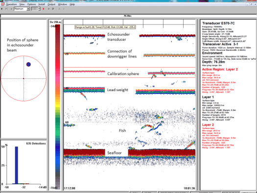
Diagram to Describe Echo Sounder Technology (Source Credit: FAO Website)

x6602ebt
Diagram to Describe Echo Sounder Technology (Source Credit: FAO Link)


Interview with a Scientist: Kim
For this leg of the research cruise Kim is on the same shift that I work on and she’s also my roommate. She has been great in helping me get accustomed to sea life and training me on what to do while we are sorting trawls in the science lab. She also agreed to let me interview her to share her story with my students. I am extremely grateful for all of the help, training, and friendship she has provided while I have been on the Dyson. Her interview is below:

IMG_0399
Kim Holding a Smooth Lumpsucker from a Bottom Trawl Survey (photo credit: Kim)

What is your educational background?
I have a bachelor’s of science degree aquatic and fishery sciences and a minor in marine biology.

How long have you been working as a scientist?
About 10 years.

How long have you been working as a NOAA contractor?
6 years.

What is your job description?
I am a stomach content analyst.

How often do you go on a survey?
Usually twice during the summer for about three weeks at a time.

What is a highlight for you while at sea?
A family of 4 got lost at sea and had been missing for 60 hours. We were out on survey and came across them in their life raft. We were able to pull them out. They wrote a book about it called “Lost in the Shelikof: an Alaskan Family’s Struggle to Survive”.

If you would like to read more about this story, here is the link to the book:  http://www.amazon.com/Lost-Shelikof-Alaskan-Familys-Struggle/dp/145650584X

What made you want to be a scientist?
I spent a lot of time on the water as a kid crabbing and playing in the water. I was always drawn to sea life and I wanted to learn as much about it as I could.

What enjoy most about being a scientist?
The survey work is my favorite part of my job. You get to see a lot of unique species that most people don’t get to see. A lot of deep water species. I also like going out on survey because most of my work is done in the lab looking at samples under a microscope. It’s refreshing to be able to travel up here and work on a boat every summer. Sometimes when I’m out here I stop and think “I can’t believe this is my job.” I learn something new every time I come out here. It’s hard work, but it’s also a lot of fun.

What is the hardest part of your job?
We have a sampling plan that tells us what species and what size range of fish we want to collect stomachs from. It can be difficult to get stomachs from all the fish that you’d like to simply because the net doesn’t catch individuals of a certain size. Fish frequently regurgitate their food when they come up in the net and it can be a challenge sometimes to find ones that haven’t thrown up.

What is your favorite sea creature?
Cuttlefish, they are pretty cute.

Here is a short YouTube video about cuttlefish if you would like to see what they look like and how they act: https://www.youtube.com/watch?v=E-zodF-XrSE

Any advice for people who want to be a scientist?
Volunteer as much as you can. Internships, especially those involving field work, are a great way to gain experience and help you decide what aspects of a particular field of science you’re most interested in. Also, having enthusiasm for the work that you’re doing goes a long way towards helping you get possible internships and job opportunities in the future. Hard work and enthusiasm are what helped me get where I am today in my career.

Personal Log:
For the first couple of days on board the Dyson we had beautiful weather blue skies, pretty clouds, beautiful scenery, and calm seas. However, experiencing calm seas came to a halt on Thursday. The wind picked up which caused the ship to rock back and forth with the waves. Gusts of wind would cause water to splash over the bow of the ship, creating a very entertaining show. I loved to watch the waves move and feel the ship’s reaction to the power of the water. When I went to visit the bridge of the ship one wave hit the boat hard enough to ring a bell that is hanging in the bridge. Sitting down to do work or eating a meal can be kind of fun when the wind is up. It’s almost like a roller coaster, because you never know when your chair is going to slide sideways. Walking while the ship was rocking was also interesting because two normal steps could become 5 so that you can keep your balance and stay on your feet.

This slideshow requires JavaScript.

On Friday we had our mandatory at sea drills. The first was a fire drill which was very easy for me because all I had to do for that drill was meet up with the rest of the science crew in a preplanned muster station. The next drill was a little more eventful. We had to bring a survival suit, a life jacket, a hat, and gloves to the preplanned muster station. Once we were there roll was called to make sure we were in the correct station to get on the correct life raft should it became necessary. This part wasn’t too bad because the scenery outside was very pretty. However, after that part was complete the people new to the ship had to put on the survival suit, which is supposed to take less than a minute to put on. This was my first attempt to get into a survival suit and I needed a lot of guidance from ENS Ben Kaiser, one of the NOAA Corps officers. He was very patient with me and also took my picture when I was finally able to get it on.

DSC02993
My First Time in a Survival Suit


The Oscar Dyson takes safety very seriously!!

This slideshow requires JavaScript.


Mary Cook: From Scammon Bay to Glacier Bay! March 17, 2016


NOAA Teacher at Sea
Mary Cook
Onboard R/V Norseman II
March 18-30, 2016

Mission: Deepwater Ecosystems of Glacier Bay National Park
Geographical Area of Cruise: Glacier Bay, Alaska
Date: Thursday, March 17, 2016

Introduction

Hello!  My name is Mary Cook and I’m a science teacher in Scammon Bay, Alaska. Scammon Bay is a cozy little Yupik village nestled at the base of the Askinuk Mountains on the edge of the vast frozen tundra where the Kun River meets the Bering Sea. We live in what many people call Bush Alaska. It’s remote. We have no roads connecting our village to other places. Everything comes and goes mostly by small Bush planes. Barges bring supplies in the warmer months. We get around locally by snow-go, 4-wheeler, or boat.

map of ak
Map of Alaska showing Scammon Bay
school entrance
Entrance to Scammon Bay School

The Yupik Eskimo of Scammon Bay are traditionally fishers, bird hunters and trappers. Moose have also become an important food source over the last 20 years or so. Today they continue with this subsistence lifestyle blended with more modern conveniences such as cell phones and running water.

My students, co-workers and I are so excited to be involved with the NOAA Teacher at Sea program! Our school has been abuzz with preparations over the last few weeks.

Congratulations to our 4th graders for making a fantastic banner to take aboard the Research Vessel Norseman II! Also, thanks to many students who submitted names for our eagle mascot.


cook poster
Scammon Bay 4th Graders with Vice Principal Harley Sundown (L), TAS Mary Cook, Principal Melissa Rivers, and 4th Grade Teacher Michele Benisek (R)

Drum roll……His name is Qanuk! (Qanuk means snowflake in the Yupik language.) I anticipate that he will make some mystery appearances around the ship in the coming days.

TAS Mary Cook styrofoam cups
Stryofoam Cups decorated by Scammon Bay students

We have decorated and signed lots of Styrofoam cups to be sent to the bottom of the Bay. We are very curious about what will happen to our cups as they descend into the depths! We also can’t wait to find out more about the secrets of the Red Tree Coral, which is the focus of the research for this voyage into Glacier Bay.

Wednesday, I left my students in Scammon Bay as I boarded the small bush plane headed for Bethel. Then flew from Bethel to Anchorage and from Anchorage on to Juneau. It was a long day of flying and waiting and flying and waiting. But the late night flight into Juneau was worth it when, as we rose above the snow clouds, I peered out the window to see a magnificent aurora glowing in the sky!


Yesterday I had a little bit of time to get out and see the sights of Juneau. My favorite was the Mendenhall Glacier. Wow! So beautiful and powerfully majestic in all its frozen splendor. In addition to the glacier, there are bald eagles perched in treetops all around town.


Last night I met many of the science crew and a few of the ship’s crew. What a positive and exciting group of people. Even they are excited about being part of the NOAA Teacher at Sea Program!

This is going to be fun—-and educational.

Don’t you just love that combination?
Fun and educational.

Today we load the ship.
Tomorrow we sail away into the Bay.

This slideshow requires JavaScript.


Virginia Warren: Life at Sea is GREAT!! March 15, 2016

NOAA Teacher at Sea Virginia Warren
Mission: Acoustic and Trawl Survey of Walleye Pollock
Geographical Area of Cruise: Shelikof Strait
on NOAA ship Oscar Dyson
Date: 3/15/2016

Data from the Bridge:
Sky:  Light and variable
Visibility: 10+ Nautical Miles
Wind Direction: West
Wind Speed: 2.50 (4 knots)
Sea Wave Height:  1 – 2, light swell
Air Temperature: 4.2 degrees C (40 degrees F)
Barometric Pressure: 1004.8


NOAA and NOAA Corps Information:

NOAA is an acronym that stands for National Oceanic and Atmospheric Administration. NOAA is a government agency that helps keep citizens informed on weather conditions and the climate. It also conducts fisheries management, and coastal restoration. As stated on their website, NOAA’s mission is to understand and predict changes in climate, weather, oceans, and coasts, to share that knowledge and information with others, and to conserve and manage coastal and marine ecosystems and resources. NOAA has nine key focus areas, 12,000 NOAA personnel, and 6,773 scientists and engineers.

If you would like to read more about what NOAA does, please check out their website here: http://www.noaa.gov/about-our-agency

The NOAA Commissioned Corps Officers are in charge of running NOAA ship Oscar Dyson. The officers keep the ship functioning properly and the people safe. The NOAA Commissioned Officer Corps is one of the seven uniformed services of the United States. As stated on the NOAA Corps website, the NOAA Corps mission is to provide officers technically competent to assume positions of leadership and command in the National Oceanic and Atmospheric Administration (NOAA) and Department of Commerce (DOC) programs and in the Armed Forces during times of war or national emergency.  If you would like read more about what the NOAA Corps does, please check out their website here:  http://www.noaacorps.noaa.gov/about/about.html

You can also watch the NOAA Corps Recruitment video here: http://www.noaacorps.noaa.gov/audiovideo/noaacorps_video.html


Science and Technology Log:

This is my second full day on the ship and my science crew has sorted three trawls. On the first day on shift, I learned that there is a lot of waiting to get the fishing pollock job done correctly. The Chief Scientist, Patrick, is responsible for choosing where and when to launch the trawl. He does this by watching data on a screen that comes from the echo sounder, which is placed under the ship. When you see bright red color on the screen, then you know there is something registering on the echo sounder. This part of the process can take several hours.

Echo Sounder Screen
Echo Sounder Screen

Once you find the fish, then you have to launch the trawl net. This is a very intricate process because as the net is being launched, it has to be kept free of tangles. If tangles occur in the net it could cause the net to rip once the trawl has begun. At the mouth of the trawl where the opening is for fish to enter, there are two large trawl doors that glide through the water like airplane wings, except the “lift” is a spreading force that goes sideways to open the mouth of the trawl for fish to enter.

awt-model-commented1
Scale model of the Aleutian Wing Trawl (AWT) net courtesy of NOAA Scientist Kresimir Williams


Once the trawl is complete, the catch is dumped onto a table that lifts up to the conveyor belt where we separate pollock from all the other types of animals. The pollock are placed into baskets where they are then weighed. A sample of pollock is taken to examine further. Data on everything that we catch goes into a computer system called CLAMS, which is an acronym for Catch Logger for Acoustic Midwater Survey. I will further explain the sorting and data collection processes, and the CLAMS program on a future blog.

This slideshow requires JavaScript.

Personal Log: 

I’m happy to report that all of my flights went great and my luggage didn’t get lost on my way to Kodiak, Alaska. I spent Friday and Saturday nights in Kodiak waiting to rendezvous with the NOAA ship Oscar Dyson Sunday morning.

This slideshow requires JavaScript.

Kodiak is a beautiful, scenic fishing community. I love that Kodiak is able to use clean, alternative-renewable energy resources to make their energy for the island. Notice the wind turbines in the picture below, however Kodiak also uses hydroelectric dams to make most of their power.

Wind Powered Turbines

The Oscar Dyson anchored up outside of the Kodiak harbor in efforts to save time by not having to completely dock up in the harbor. The Dyson sent out its small boat called “The Peggy D” to take people to and from the ship. We put really warm jackets that also served as life jackets(float coats).

The "Peggy"

I loved this boat ride because it gave me a view of the harbor I hadn’t been able to see yet!

Beautiful Mountains from the Harbor in Kodiak, Alaska

My first view of the Oscar Dyson was spectacular. I saw it as we rounded a very small island outside of the harbor. With the mountains in the background, the ship made a pretty picture.

NOAA Ship Oscar Dyson

This is only the beginning of the trip and I am so looking forward to experience the rest of it.

This slideshow requires JavaScript.


Virginia Warren: All My Bags are Packed, I’m Ready to Go!!! March 9, 2016

Hi! My name is Virginia Warren. I teach 5th Grade math and science at Breitling Elementary School in Grand Bay, Alabama. I have been a teacher for 6 years. I am currently in the process of going back to graduate school at the University of South Alabama to get my Master’s Degree in Instructional Design and Development.

I am set to fly out of Pensacola, Florida this coming Thursday morning. I will have a short layover at the Dallas Fort Worth Airport in Texas.Then, I will be off again to Seattle, Washington where I will stay the night before finishing my journey the next day. I am excited about getting to spend even a short amount of time in Seattle because I have never been on the West Coast of the United States. I plan to get as much sight seeing in as possible before my flight to Anchorage, Alaska the next morning. Once I get to Anchorage, I will catch another plane to Kodiak, Alaska where I will rendezvous with the rest of the science crew and the NOAA Ship Oscar Dyson on Saturday.

Flight Diary
This image is created from http://flightdiary.net/ and it depicts the flights that I will take to get to Kodiak, Alaska.


This will be my second NOAA Teacher at Sea opportunity. In the summer of 2013 I participated in a sea scallop survey on the Research Vessel Hugh R. Sharp. As a teacher this experience has become invaluable to me because it made scientific research come alive to me in way that I had never been able to express to my students prior to this experience. I am extremely excited about having a second opportunity to travel the world and learn about real data research. I am also excited to be able to share this trip with my 5th grade students back home in Grand Bay, Alabama.

edited2 without man behind me.jpg
This picture is from my first NOAA Teacher at Sea research cruise in 2013 aboard the R/V Hugh R. Sharp

I will spend about 2 weeks aboard the NOAA Ship Oscar Dyson participating in an acoustic-trawl survey to estimate pollock abundance in Shelikof Strait.


Rebecca Loy, Sad to Say Goodbye, September 24, 2015

NOAA Teacher at Sea
Rebecca Loy
Aboard NOAA Ship Rainier
September 8 – 24 , 2015

Mission: Hydrographic Survey
Geographical area of Research: Kodiak Island, Alaska
Date: September 24, 2015

Current Location: Kodiak, Alaska

Noaa corps banner depicting work done by noaa corps officer and the logo's of NOAA Corps and DOC

While NOAA is a larger organization, I thought it might be nice for people to learn about the group that took such excellent care of me while I was at sea.  I am talking about the NOAA Corps.  These are the officers that get the ship where it needs to go safely.  NOAA Corps is one of the seven uniformed services in the United States.  It has a long history starting as Survey of the Coast which was established by Thomas Jefferson in 1807.  The 321 officers in NOAA Corps not only work on and operate ships, but they also fly airplanes, facilitate research projects, conduct dive operations and work as staff throughout NOAA.

Press the link to learn more about NOAA Corps.  This could lead to an amazing career for someone!

Path to Rainier:

I thought it would be appropriate for me to highlight one of the NOAA officers.  They have all been wonderful to me and have taught me so much, it is hard for me to pick just one person.  I wish I could highlight them all.   One person that I could go to for anything, gave me my tour of Rainier and worked with me on the ship and on the shore is ENS Shelley Devereaux.

ENS Shelley Devereaux and I on the bridge.

The NOAA Corps officers do so much.  I enjoyed sitting with ENS Devereaux and learning more about what she does and how she got to Rainier.   ENS Devereaux told me she does a little bit of everything, which is very true.  She works on navigation, standing watch, logistics of planning details for when the ship is inport including mail delivery and organizing the “liberty van” that takes crew into town.  ENS Devereaux does survey work and is the tide assistant (she was with me when we installed the tide gauge earlier).  I have only listed a few things here, all of the officers work very hard and are pretty amazing people!

ENS Devereaux started as a math major in college.  She also did some work as a bicycle mechanic, a pastry chef, worked as a research assistant for a bio lab and was a data manager for an educational non-profit.  She realized she missed science and went back to school to get her Master’s Degree in Geographic Information Systems.  She studied mapping applied to many areas of study including data visualization.

She learned about NOAA Corps when her uncle told her and her cousin about it.  ENS Devereaux’s cousin applied first and then she followed.  Her cousin in on Rainier’s sister ship, Fairweather.  Interestingly, the two cousins had a chance to meet up this past summer in the Arctic.

ENS Devereaux inputting data at the tide gauge installation.

ENS Devereaux told me more about the NOAA Corps.  She had to undergo training for 6 months with the Coast Guard Academy (the two services work together for training).  There she learned ship navigation, firefighting, First Aid, driving the rescue boats and how to be an officer plus much more.  After her initial training, she had further training with NOAA for safety, teamwork, communication, leadership skills and problem solving.  ENS Devereaux truly enjoys the hands on work, being part of a team, serving and creating charts for safe navigation.

When I asked ENS Devereaux where she has been in the world, she told me she traveled to parts of Europe and Costa Rica, but the most interesting part is she backpacked by herself through Mongolia, China and Taiwan.  I was not surprised that this dynamic woman would take on this challenge.

Tide install with Rainier in the background.

Like all of the officers on Rainier, ENS Devereaux is a pretty spectacular person.  Knowing that people like her, including her NOAA Corps colleagues, are serving and taking care of our oceans is very reassuring.   Thank you for everything you have done for me and our planet.


Personal Log:

Sunrise from Shelikoff Strait.
Hello there!
Hello there!

My time here on Rainier is drawing to a close.  When I first arrived, it was all so new and exciting and I must admit it was a bit overwhelming.  Now, almost 3 weeks later, I feel like an integral part of this crew.  While this ship is incredible, it is the people who make it their work and home that make it truly special.

This hard working crew has included me in everything!  I was given every opportunity possible so I could bring this experience back to my community – and I have some wonderful ideas thanks to them!!!

Kizhuyak Bay
Kizhuyak Bay

I learned more than just how this ship runs or what hydrographic surveys are.   More importantly, I watched this group of people be problem solvers.  We often teach our students how to resolve a situation.  Being on Rainier showed me that this is a skill that needs to continually be exercised!

I thought this was an interesting beach photo.

I appreciated how a situation would present itself and the crew would move into action!  This could be something less intense like planning our route from bay to bay around Kodiak Island to more involved problem solving such as repairs/maintenance to the MVP on the back of the ship.  A group of people would start thinking, brainstorming, testing, reviewing and thinking some more.  They came together from different departments and areas of expertise to solve an issue.  It was incredible to be a part of this process and something I plan to facilitate more in my teaching.

Watching the shore go by
Tide install with sunrise

I have the greatest respect for this unique group of people.  I am going to miss a lot here… the easy comradery they have with each other, sharing our wish for better internet among the mountains, looking for wildlife or the aurora borealis together, eating PB&J sandwiches with the most incredible views, having dessert with lunch AND dinner, 18:00 movie time (6:00 PM for those of you on shore), watching the beautiful Alaskan coast go by, whales…whales and more whales, the unique names that are used throughout the ship (the Holodeck, Princess Suite, engineer Hollywood just to name a few), line handling and all kinds of deck work, learning how to use a crane and not getting the Bo’sun wet, watching the launches come out of and into their cradles, hanging on to EVERYTHING as the ship rolls and pitches (yes, even this), looking at ENS Kosten and ENS Devereaux’s beautiful photos, hearing about everyone’s incredible experiences- especially in the Arctic, bumping my head in engineering, and most importantly, being my nerdy self with people who understand!

I am very thankful to NOAA ship Rainier Commanding Officer EJ Van Den Ameele for being so kind and allowing me this opportunity, to Rainier’s officers and crew for being so helpful and supportive as I learned my way around asking a million and one questions (no joke, I should have kept track of how many I asked) and to the NOAA Teacher at Sea program.

I hope to make you all proud as I head back home and share this incredible experience!

Rainier from a launch in Kizhuyak Bay