Virginia Warren: Home Sweet Home

NOAA Teacher at Sea Virginia Warren
Mission: Acoustic and Trawl Survey of Walleye Pollock
Geographical Area of Cruise: Shelikof Strait
on NOAA ship Oscar Dyson
Date: 3/25/2016

Science and Technology Log:

This slideshow requires JavaScript.


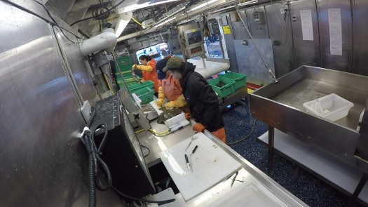
I created the video below  to document some of my activities aboard the Oscar Dyson during my 2016 Teacher at Sea research trip.

In this video, Virginia opens with exciting footage from the front of the Oscar Dyson’s bow as they transit through Alaska’s Shelikof Strait. Interspersed, she shares various steps involved in processing the fish caught in the survey: sorting the catch by species (0:34), collecting the pollock into bins (1:00), making an incision to determine the sex of the pollock (1:07), measuring the pollocks’ lengths and taking biological samples (1:33), removing the otoliths (2:23 and 3:29), preserving the otoliths for analyzing on shore (3:12), and measuring and recording other fish using the Ichthystick and the CLAMS computer program (3:57). Virginia also takes the opportunity to show off some interesting species—lumpsucker fish (2:18), starry flounder (2:53), and salmon (3:53). Finally, Virginia gives a brief tour of the deck (4:38) and finishes with a photo of her wearing a survival (or “Gumby”) suit (5:02.)

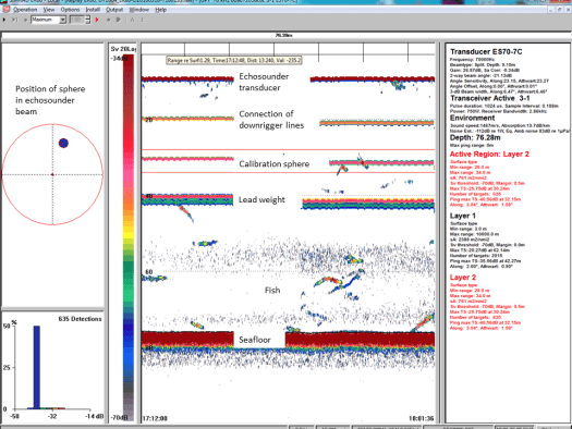
My students know a good bit about my previous Teacher at Sea experience out of Woods Hole, Massachusetts where we used the HabCam to look at the ocean floor. With that knowledge in mind a couple of my students asked me if there was a way that we were able to look at the fish while they were still in the water. The simple answer to that question is yes. While my previous TAS experience used the HabCam, the Oscar Dyson uses a CamTrawl. The CamTrawl is attached to the net and it records pictures as fish enter the  cod end of the net.

AWT001_camtrawl2
Image from the CamTrawl


DSC02936
CamTrawl
DSC02920
Nick and Ryan Attaching the CamTrawl to the Net


After each trawl we would use custom software written in MATLAB to measure lengths of pollock while they were in the water. This program uses the pictures taken from the CamTrawl during the trawl to measure the length of the fish. The CamTrawl takes two pictures at different angles so that most of the time we can see the same fish from two different angles. Fish length irregularities occur in the MATLAB program when it selects nets or two fish at one time to length, so therefore a person has to go back and check to make sure that the program has selected valid fish to length. As the fish pictures come up on the MATLAB screen the person rating the fish selects the fish when the yellow box around the fish covers most of the fish from both angle camera shots of the CamTrawl.

Untitled
A Screen in MATLAB that Shows Valid Fish Lengths

The above picture shows three different fish that were valid choices for length measurement. The pictures on the left show one camera angle and the pictures on the right show the other camera angle. When both angles have a valid fish with the correct placement of the yellow box, the person selecting the fish will click the fish to tell the program to use that fish in the measurement data.


Interview With a NOAA Survey Technician: Alyssa Pourmonir 

Alyssa Pourmonir inside the Wet Lab
  1. How did you come to be in NOAA Corps? (or what made you decide to join NOAA Corps and not another military branch.

I am not in the NOAA Corps, instead I am a civilian government employee under the title of Survey Technician. I was in the US Coast Guard for 3 years where I took many courses related to navigation, leadership, and ship life. I feel my background in the Coast Guard has allowed me to excel in this demanding environment.

  1. What is your educational/working background?

I have been lucky to have the opportunity to be in the Coast Guard which taught me many professional skills and built me up to be stronger and more independent. I also spent an entire summer forecasting for the weather in Pennsylvania. Here I gained an abundance of practice presenting the weather on the green screen and performing on live television for WNEP TV. Before coming to Alaska for this job, I worked as a consultant at NASA Stennis Space Center performing remote sensing analysis of forests using data from the MODIS and VIIRS data.

Academically, I have a BS in Marine Environmental Science from SUNY Maritime College, although most of my college experience took place at the US Coast Guard Academy.

  1. How long have you been in NOAA Corps?

I’m not in the NOAA Corps, but I have worked for NOAA for almost 2 years as a Survey Technician. May 2014 to present.

  1. How long have you been on the Dyson?

June 2014 to present.

  1. How long do you usually stay onboard the ship before going home?

In the past 2 years I have visited my family one time. Partly because I wish to send money home so my family can struggle a little less and hopefully enjoy a life with less debt; especially as my father passes retirement age. He has worked several full time jobs at a time for many years just to support my mom and sisters. Potentially, his work ethic and care giving nature is what I try to embody each day.

  1. Have you worked on any other NOAA ships? If so, which one and how long did you work on it?

Nope

  1. What is your job description on the Dyson?

On the NOAA Oscar Dyson, I am a crew member who acts as a liaison to the scientific personnel on board. I work up to 12 hours each day, 7 days per week maintaining the scientific data, equipment, and lab spaces on board. I also work alongside the scientists, deck department, and bridge watch standers to collect data by completing many different oceanographic or fishing operations.

  1. How is your science job on the Dyson different from the NOAA Scientists that you work with?

As a crew member, I facilitate a positive environment with the needed resources for the scientists to fulfill their data analysis and data collection. I also work alongside the scientists to process the fishing catch in our lab. So you can imagine me suited up with the scientists analyzing the fish’s reproduction development stages and extracting otoliths.

  1. What is the best part of your job?

I get to explore and work in the infamous Bering Sea Alaska, Gulf of Alaska, and Aleutian Island chain which most people can’t even imagine doing. Here in Alaska, I do not have the luxuries found in Continental US, so I believe out here there is a great opportunity for character building. It takes someone pretty amazing to live out here and do what we do.

  1. What is the most difficult part of your job?

Being in remote places and not seeing family or friends, but also being so far away that it is super expensive to try to see them.

  1. Do you have any career highlights or something that stands out in your mind that is exceptionally interesting?

I began my BS absolutely hating biology. I dislike and do not eat seafood. I was skittish and would let my partners do all of the dissections during classes, and I felt that I knew nothing about biology. As a Marine Environmental Science major I decided to take as many biology electives as I could. I went from the lowest grade in my classes to someone who received one of the highest grades in each class. I graduated just one class shy of a minor in Marine Biology and now toss around fish on the NOAA Ship Oscar Dyson, a fisheries research vessel. While my first day I would jump when the fish would move unexpectedly, now I can analyze characteristics of the fish with little alarm and much confidence. It is amazing how I enjoy biology now. I hope to encourage others to confidently try new things, for with a little practice and hard work you may accomplish anything or overcome fears you may not have realized you had.

  1. Do you have any advice for students who want to pursue a career with NOAA?

If you wish to pursue a career with NOAA, be sure to work hard to learn as much as you can, but also come out of your comfort zone to pursue as many volunteer or paid jobs that will give you work experience that correlates with your interests. Time management and resilience is often my secret to success.

Personal Log:

I had a fabulous time aboard NOAA Ship Oscar Dyson and I’m very thankful to NOAA giving me the opportunity to travel to Alaska and learn from their scientists!!!

This slideshow requires JavaScript.

My flight home started on a small plane from Kodiak to Anchorage.

20160324_144957
Ravn Alaska’s Bombardier DHC-8-100


After the plane got into the air and was flying away from Kodiak, we were treated to a flyby of the Kodak Harbor and even got to see the Dyson outside of the harbor as we flew away.

20160324_150614
Aerial view of the Kodiak Harbor

We flew into Anchorage, Alaska and I was amazed at the beauty of the mountains in Alaska!

20160324_195443
Mountains Outside the Anchorage, Alaska Airport

A little while before sunset I caught a plane from Anchorage to the Chicago, O’Hare airport. The scenery and sunset leaving Alaska was beautiful!!!! I hope this won’t be the last time I get to come to Alaska, because it is a beautiful, adventure-filled part of the United States.

This slideshow requires JavaScript.


It was good to be back on land again when we got back to Kodiak, but I do miss being on the ocean!!

20160324_132915
Bow of the Oscar Dyson
20160324_103709
NOAA Ship Oscar Dyson


20160324_103737
Finally back on land in front of the NOAA Ship Oscar Dyson!

This experience was wonderful for me, however for my students this experience was invaluable. I was able to communicate and share my experiences with them through email almost daily and they were also able to read my TAS blogs as they were posted. If they don’t learn anything else from my experiences in Alaska, which I know that they will, I hope they will learn that the world is theirs to explore, study, and learn about no matter how small the town is that they come from!!

Virginia Warren: CLAMS and Trawls March 22, 2016

NOAA Teacher at Sea Virginia Warren
Mission: Acoustic and Trawl Survey of Walleye Pollock
Geographical Area of Cruise: Shelikof Strait
on NOAA ship Oscar Dyson
Date: 3/20/16 – 3/22/16

Data from the Bridge (3/21/16):
Sky: Snow
Visibility: 8 to 10 nautical miles (at one point it was more like 2 to 3 nautical miles)
Wind Speed: 23 knots
Sea Wave Height: 4 – 6 feet
Sea Water Temperature: 5° C (41°)
Air Temperature: 0° C (32° F)
Barometric (Air) Pressure: 994.3 Millibars

Science and Technology Log:
The purpose of this research survey is to collect data on walleye pollock (Gadus chalcogrammus) that scientists will use when the survey is complete to help determine the population of the pollock. This data also helps scientists decide where and when to open the pollock fishery to fishermen. Data collection such as this survey are critical to the survival and health of the pollock fishery.

As I mentioned in a previous blog post, we use an AWT (Aleutian Wing Trawl) to complete the pollock survey. The AWT has two doors that glide through the water and hold the net open. The cod end of the net is where all of the fish end up when the trawl is complete.

awt-model-commented1
Scale model of the Aleutian Wing Trawl (AWT) net courtesy of NOAA Scientist Kresimir Williams (Source: TAS Melissa George)

After the trawl is brought back onto the boat, the cod end of net is dumped onto a hydraulic table. The hydraulic table is then lifted up so that it angles the fish down a shoot into the Wet Lab on a conveyor belt.


Once the pollock come through the shoot and onto the conveyor belt, the first thing that we do is pick out every type of animal that is not a pollock. So far we have found lots of eulachons (Thaleichthys pacificus), jellyfish (Cnidaria), isopods, and squid. We have even found the occasional chinook salmon (Oncorhynchus tshawytscha), rock fish (Sebastes spp.), and a lumpsucker (Cyclopteridea). The pollock continue to roll down the conveyor belt into a plastic bin until the bin is full. Then the bin of pollock are weighed.

Contents of the Trawl

This slideshow requires JavaScript.


The data from every fish we sample goes into a computer system called CLAMS. CLAMS stands for Catch Logger for Acoustic Midwater Survey. While we are taking samples of the fish our gloves get covered in fish scales and become slimy, so to be able to enter the data into the CLAMS system without causing damage there is a touch screen on all of the computers in the Wet Lab.


20160322_161321
CLAMS computer system with a touch screen.


Once the pollock are weighed, a sample of the fish are taken to be sexed. To sex the fish, we use a scalpel to slice into the side of the fish. The picture of the chart below shows what we are looking for to determine if a pollock is male or female. Once we know what sex the fish is, we put it into a bin that says “Sheilas” for the female fish and “Blokes” for the male fish.

DSC02989

This chart of the Maturity Scale for Walleye Pollock is hanging in the Wet Lab.

DSC02937
Up-close of the Maturity Scale for female pollock.

DSC02988

Up-close of the Maturity Scale for male pollock.


Sexing the fish1

Kim showing Virginia what to look for when sexing the fish.

Once the fish are in their correct male/female bin, they are then measured for their length using an Ichthystick.

The Ichtystick was designed and built by MACE staff Rick Towler and Kresimir Williams who wrote a paper on it: http://www.sciencedirect.com/science/article/pii/S0165783610001517

The Ichthystick has a magnet under the board. When the fish is placed on top of the board, a hand held magnet is placed at the fork of the fish tale. Where the hand held magnet is attracted to the magnet under the board tells the computer the length of the fish and the data is automatically stored in the CLAMS program.

DSC03092
Ichtystick
Starry Flounder Length
Getting the length of the starry flounder using the Ichthystick.

The next station is where the stomach, ovaries, and otoliths are removed from the fish and preserved for scientists to research when the survey is over. The ovaries of a female fish are weighed as well. Depending on the size of the ovaries, they may be collected for further research. Once all of the data has been collected from the fish, a label is printed with the data on it. This label is placed in the bag with the stomach or ovaries sample. Kim completes a special project for this survey. She is a stomach content analysist, so she collects stomachs from a sample of fish that will be taken back to her lab to analyze the stomach content of what she collected. She puts the stomach and the label with the fish’s information, into a bag that is placed in a solution of formalin that preserves the samples.

This slideshow requires JavaScript.

The next step is to get the otoliths out of the fish. A knife is used to cut across the head of the pollock. Otoliths are used to learn the age of the fish. The otoliths are placed in a glass vile that has a barcode number that can be scanned and put with all of the fish’s information in CLAMS. This number is used to keep track of the fish data for when the otoliths get analyzed later on.

Getting the Otoliths

This slideshow requires JavaScript.

We also collect length, weight, sex, and stomach samples from other fish that come up in the trawl as well.

Interview with a NOAA Corps Officer: Ensign Caroline Wilkinson
Caroline is a Junior NOAA Corps Officer on board the NOAA ship Oscar Dyson. She is always very helpful with any information asked of her and always has a smile on her face when she does so. Thank you Caroline for making me feel so welcomed on board the Dyson!

DSC03089
Ensign Caroline Wilkinson

How did you come to be in NOAA Corps? (or what made you decide to join NOAA Corps and not another military branch?

  • I graduated from college in May of 2015. I was looking for a job at a career fair at my school and discovered the NOAA Corps. I had heard of NOAA, but didn’t know a lot about NOAA Corps. I wanted to travel and NOAA Corps allowed me that opportunity. I was unsure what type of work I wanted to do, so I decided to join and explore career options or make a career out of NOAA Corps.

What is your educational/working background?

  • I went to the University of Michigan where I received an undergraduate degree in ecology and evolutionary biology and a minor in physical oceanography.

How long have you been in NOAA Corps?

  • July of 2015 I started basic training. Training was at the Coast Guard academy in a strict military environment. We had navigation and ship handling classes seven hours a day.

How long have you been on the Dyson?

  • I have been here since December of 2015.

How long do you usually stay onboard the ship before going home?

  • We stay at sea for two years and then in a land assignment for 3 years before heading back to sea.

Have you worked on any other NOAA ships? If so, which one and how long did you work on it?

  • Nope, no other ships. I had no underway experience except a five-day dive trip in Australia.

Where have you traveled to with your job?

  • We were in Newport, Oregon and then we went to Seattle, Washington for a couple of weeks. Then we went to Kodiak and then to Dutch Harbor.

What is your job description on the Dyson?

  • I’m a Junior Officer, the Medical Officer, and the Environmental Compliance Officer. As a junior officer I am responsible for standing bridge watch while underway. As a Junior Officer I am responsible for standing 8 hours of watch, driving the ship, every day. As medical officer, we have over 150 drugs onboard that I am responsible for inventorying, administering, and ordering. I also perform weekly health and sanitary inspections and Weekly environmental walkthroughs where I’m looking for any safety hazards, unsecured items, leaks or spills that could go into the water.

What is the best part of your job?

  • Getting to drive the ship.

What is the most difficult part of your job?

  • Being so far away from my family and friends.

Do you have any career highlights or something that stands out in your mind that is exceptionally interesting?

  • During training we got to sail in the US Coast Guard Cutter Eagle. It’s a tall ship (like a pirate ship). We were out for eight days. We went from Baltimore to Port Smith, Virginia and had the opportunity to do a swim call 200 miles out in the Atlantic.

What kind of sea creature do you most like to see while you are at sea?

  • We have seen some killer whales and humpback whale in the bay we are in this morning. We’ve also seen some albatross.

Do you have any advice for students who want to join NOAA Corps?

  • You need an undergraduate degree in math or science. There are 2 classes of ten students a year. Recruiters look for students with research experience, a willingness to learn, and a sense of adventure.
DSC03090
Ensign Caroline Wilkinson at the helm.


Personal Log:
I have really been enjoying my time aboard the Oscar Dyson and getting to know the people who are on the ship with me. I love spending time on the Bridge because you can look out and see all around the ship. I also like being on the bridge because I get to witness, and sometimes be a part of, the interactions and camaraderie between the NOAA Corps Officers that drive/control the ship and the other ship workers.

DSC03085
Panoramic view of the NOAA Ship Oscar Dyson‘s Bridge. Look at all of those windows!


Arnold and Kimrie are responsible for making breakfast, lunch, and dinner for all 34 people on the Oscar Dyson. They also clean the galley and all of the dishes that go along with feeding all of those people. They probably have the most important job on the ship, because in my previous experiences, hungry people tend to be grouchy people.

20160322_095134
Arnold and Kimrie are the stewards of the Oscar Dyson.


We’ve had a variety of yummy dishes made for us while we’ve been at sea. Breakfast starts at 7 a.m. and could include a combination of scrambled eggs, breakfast casserole, French toast, waffles, chocolate pancakes, bacon, sausage, or my personal favorite, eggs benedict.

20160322_070541
Breakfast is served. YUM!!!

Lunch is served at 11 a.m. and seems like a dinner with all of the variety of choices. Lunch usually has some type of soup, fish, and another meat choice available, along with vegetables, bread, and desert. Dinner is served at 5 p.m. and usually soup, fish, and another meat choice available, along with vegetables, bread and desert. I loved getting to try all of the different types of fish that they fix for us and I also really liked getting to try Alaskan King Crab for the first time!!

If you are still hungry after all of that, then there is always a 24-hour salad bar, a variety of cereal, snacks, and ice cream available in the galley. The left-overs from previous meals are also saved and put in the refrigerator for anyone to consume when they feel the need. If we are working and unable to get to the galley before a meal is over, Arnold or Kimrie will save a plate for us to eat when we get finished.

I also tried Ube ice cream, which is purple and made from yams. At first I was very skeptical of any kind of sweet treat being made out of yams, but I was pleasantly surprised that it tasted really good!

DSC02999
Ube ice cream made from yams! Very YUMMY!!!


There is even a place to do laundry on this ship, which I was very happy about because fishy clothes can get pretty stinky!

DSC03081
Laundry Room

I can’t end a blog without showing off some of the beautiful scenery that I have been privileged to see on this journey. The pictures below are of the Semidi Islands.

This slideshow requires JavaScript.


Virginia Warren: Calibrations, Drills, and Interviews March 19, 2016

NOAA Teacher at Sea Virginia Warren
Mission: Acoustic Trawl Survey of Walleye Pollock
Geographical Area of Cruise: Shelikof Strait
on NOAA ship Oscar Dyson
Date: 3/17/16 – 3/18/16

Data from the Bridge:
Sky: Cloudy
Visibility: 10 Nautical Miles
Wind Direction: 0.2 (20°) From the Northeast
Wind Speed: 25 Knots (30 Knots at point during the day)
Sea Wave Height: 5 – 6 ft. on average (10 ft. at highest)
Sea Water Temperature: 5.6° C (42.08° F)
Dry Temperature: 4° C (40° F)
Barometric (Air) Pressure: 1018.4

Science and Technology Log:
When the wind picked up, it was decided that the ship would quit fishing and running transect lines with the echo-sounder and instead go into one of Kodiak’s bays to seek protection from the weather (>40 knot winds and 16 – 20 foot sea waves were forecast). While were were ‘hiding’, the ship’s crew had time to fix a trawl winch problem and change nets, and the scientists conducted a calibration of the echo-sounder (this is done at the beginning and end of surveys). When we left the transect line, we went through Alitak Bay and stopped the ship in front of Hepburn Peninsula, with Deadman Bay to the left of the peninsula and Portage Bay to the right (if you are looking at the map). Where the ship was sitting, the bay was 74.8 m (245.4068 ft) deep and 5.6° C (42.08° F). It was still pretty windy (15-20 knots), but the Hepburn Peninsula blocked us from a lot of the wind.

This slideshow requires JavaScript.

DSC02951
Deadman Bay to the left of Hepburn Peninsula and Portage Bay to the right

The calibration process of the echo sounder took some time. The science crew before me already started the process of calibrating the echo sounder before it was time for my shift to take over. They used three down riggers to send three lines under the center of the boat, where the echo sounder is positioned. A calibration sphere was placed a little further down one of the lines. There is also a lead weight put at the end of the line so that it will help hold the calibration sphere in place as the current moves.

tomichFig1
Echo Sounder Calibration Diagram (Source Credit: Sea Technology Website)

Then one of the science crew uses a system to align the calibration sphere with the echo sounder. There are two types of calibration spheres that we used today. The first, and smaller one, was made out of a tungsten-carbide alloy.

patrick-with-sphere1_small
Patrick holding the Tungsten-Carbide Calibration Sphere (photo by Julia Harvey, TAS summer 2013 DY1307)

The second calibration sphere was larger than the first and it was made out of solid copper. This made for a very easy, get a blog done, day for me because the job was completed by the lead scientist Patrick and Robert, one of the other science crew members.

DSC02956
Robert Putting the Copper Calibration Sphere on the Line


Echosounder calibration screen
Echo-sounder display during calibration. On the echogram (depth on vertical axis, time on horizontal axis) you can see the calibration spheres hanging below the ship above the seafloor. (credit: Patrick Ressler)


x6602ebs

Diagram to Describe Echo Sounder Technology (Source Credit: FAO Website)

x6602ebt
Diagram to Describe Echo Sounder Technology (Source Credit: FAO Link)


Interview with a Scientist: Kim
For this leg of the research cruise Kim is on the same shift that I work on and she’s also my roommate. She has been great in helping me get accustomed to sea life and training me on what to do while we are sorting trawls in the science lab. She also agreed to let me interview her to share her story with my students. I am extremely grateful for all of the help, training, and friendship she has provided while I have been on the Dyson. Her interview is below:

IMG_0399
Kim Holding a Smooth Lumpsucker from a Bottom Trawl Survey (photo credit: Kim)

What is your educational background?
I have a bachelor’s of science degree aquatic and fishery sciences and a minor in marine biology.

How long have you been working as a scientist?
About 10 years.

How long have you been working as a NOAA contractor?
6 years.

What is your job description?
I am a stomach content analyst.

How often do you go on a survey?
Usually twice during the summer for about three weeks at a time.

What is a highlight for you while at sea?
A family of 4 got lost at sea and had been missing for 60 hours. We were out on survey and came across them in their life raft. We were able to pull them out. They wrote a book about it called “Lost in the Shelikof: an Alaskan Family’s Struggle to Survive”.

If you would like to read more about this story, here is the link to the book:  http://www.amazon.com/Lost-Shelikof-Alaskan-Familys-Struggle/dp/145650584X

What made you want to be a scientist?
I spent a lot of time on the water as a kid crabbing and playing in the water. I was always drawn to sea life and I wanted to learn as much about it as I could.

What enjoy most about being a scientist?
The survey work is my favorite part of my job. You get to see a lot of unique species that most people don’t get to see. A lot of deep water species. I also like going out on survey because most of my work is done in the lab looking at samples under a microscope. It’s refreshing to be able to travel up here and work on a boat every summer. Sometimes when I’m out here I stop and think “I can’t believe this is my job.” I learn something new every time I come out here. It’s hard work, but it’s also a lot of fun.

What is the hardest part of your job?
We have a sampling plan that tells us what species and what size range of fish we want to collect stomachs from. It can be difficult to get stomachs from all the fish that you’d like to simply because the net doesn’t catch individuals of a certain size. Fish frequently regurgitate their food when they come up in the net and it can be a challenge sometimes to find ones that haven’t thrown up.

What is your favorite sea creature?
Cuttlefish, they are pretty cute.

Here is a short YouTube video about cuttlefish if you would like to see what they look like and how they act: https://www.youtube.com/watch?v=E-zodF-XrSE

Any advice for people who want to be a scientist?
Volunteer as much as you can. Internships, especially those involving field work, are a great way to gain experience and help you decide what aspects of a particular field of science you’re most interested in. Also, having enthusiasm for the work that you’re doing goes a long way towards helping you get possible internships and job opportunities in the future. Hard work and enthusiasm are what helped me get where I am today in my career.

Personal Log:
For the first couple of days on board the Dyson we had beautiful weather blue skies, pretty clouds, beautiful scenery, and calm seas. However, experiencing calm seas came to a halt on Thursday. The wind picked up which caused the ship to rock back and forth with the waves. Gusts of wind would cause water to splash over the bow of the ship, creating a very entertaining show. I loved to watch the waves move and feel the ship’s reaction to the power of the water. When I went to visit the bridge of the ship one wave hit the boat hard enough to ring a bell that is hanging in the bridge. Sitting down to do work or eating a meal can be kind of fun when the wind is up. It’s almost like a roller coaster, because you never know when your chair is going to slide sideways. Walking while the ship was rocking was also interesting because two normal steps could become 5 so that you can keep your balance and stay on your feet.

This slideshow requires JavaScript.

On Friday we had our mandatory at sea drills. The first was a fire drill which was very easy for me because all I had to do for that drill was meet up with the rest of the science crew in a preplanned muster station. The next drill was a little more eventful. We had to bring a survival suit, a life jacket, a hat, and gloves to the preplanned muster station. Once we were there roll was called to make sure we were in the correct station to get on the correct life raft should it became necessary. This part wasn’t too bad because the scenery outside was very pretty. However, after that part was complete the people new to the ship had to put on the survival suit, which is supposed to take less than a minute to put on. This was my first attempt to get into a survival suit and I needed a lot of guidance from ENS Ben Kaiser, one of the NOAA Corps officers. He was very patient with me and also took my picture when I was finally able to get it on.

DSC02993
My First Time in a Survival Suit


The Oscar Dyson takes safety very seriously!!

This slideshow requires JavaScript.


Virginia Warren: Life at Sea is GREAT!! March 15, 2016

NOAA Teacher at Sea Virginia Warren
Mission: Acoustic and Trawl Survey of Walleye Pollock
Geographical Area of Cruise: Shelikof Strait
on NOAA ship Oscar Dyson
Date: 3/15/2016

Data from the Bridge:
Sky:  Light and variable
Visibility: 10+ Nautical Miles
Wind Direction: West
Wind Speed: 2.50 (4 knots)
Sea Wave Height:  1 – 2, light swell
Air Temperature: 4.2 degrees C (40 degrees F)
Barometric Pressure: 1004.8


NOAA and NOAA Corps Information:

NOAA is an acronym that stands for National Oceanic and Atmospheric Administration. NOAA is a government agency that helps keep citizens informed on weather conditions and the climate. It also conducts fisheries management, and coastal restoration. As stated on their website, NOAA’s mission is to understand and predict changes in climate, weather, oceans, and coasts, to share that knowledge and information with others, and to conserve and manage coastal and marine ecosystems and resources. NOAA has nine key focus areas, 12,000 NOAA personnel, and 6,773 scientists and engineers.

If you would like to read more about what NOAA does, please check out their website here: http://www.noaa.gov/about-our-agency

The NOAA Commissioned Corps Officers are in charge of running NOAA ship Oscar Dyson. The officers keep the ship functioning properly and the people safe. The NOAA Commissioned Officer Corps is one of the seven uniformed services of the United States. As stated on the NOAA Corps website, the NOAA Corps mission is to provide officers technically competent to assume positions of leadership and command in the National Oceanic and Atmospheric Administration (NOAA) and Department of Commerce (DOC) programs and in the Armed Forces during times of war or national emergency.  If you would like read more about what the NOAA Corps does, please check out their website here:  http://www.noaacorps.noaa.gov/about/about.html

You can also watch the NOAA Corps Recruitment video here: http://www.noaacorps.noaa.gov/audiovideo/noaacorps_video.html


Science and Technology Log:

This is my second full day on the ship and my science crew has sorted three trawls. On the first day on shift, I learned that there is a lot of waiting to get the fishing pollock job done correctly. The Chief Scientist, Patrick, is responsible for choosing where and when to launch the trawl. He does this by watching data on a screen that comes from the echo sounder, which is placed under the ship. When you see bright red color on the screen, then you know there is something registering on the echo sounder. This part of the process can take several hours.

Echo Sounder Screen
Echo Sounder Screen

Once you find the fish, then you have to launch the trawl net. This is a very intricate process because as the net is being launched, it has to be kept free of tangles. If tangles occur in the net it could cause the net to rip once the trawl has begun. At the mouth of the trawl where the opening is for fish to enter, there are two large trawl doors that glide through the water like airplane wings, except the “lift” is a spreading force that goes sideways to open the mouth of the trawl for fish to enter.

awt-model-commented1
Scale model of the Aleutian Wing Trawl (AWT) net courtesy of NOAA Scientist Kresimir Williams


Once the trawl is complete, the catch is dumped onto a table that lifts up to the conveyor belt where we separate pollock from all the other types of animals. The pollock are placed into baskets where they are then weighed. A sample of pollock is taken to examine further. Data on everything that we catch goes into a computer system called CLAMS, which is an acronym for Catch Logger for Acoustic Midwater Survey. I will further explain the sorting and data collection processes, and the CLAMS program on a future blog.

This slideshow requires JavaScript.

Personal Log: 

I’m happy to report that all of my flights went great and my luggage didn’t get lost on my way to Kodiak, Alaska. I spent Friday and Saturday nights in Kodiak waiting to rendezvous with the NOAA ship Oscar Dyson Sunday morning.

This slideshow requires JavaScript.

Kodiak is a beautiful, scenic fishing community. I love that Kodiak is able to use clean, alternative-renewable energy resources to make their energy for the island. Notice the wind turbines in the picture below, however Kodiak also uses hydroelectric dams to make most of their power.

Wind Powered Turbines

The Oscar Dyson anchored up outside of the Kodiak harbor in efforts to save time by not having to completely dock up in the harbor. The Dyson sent out its small boat called “The Peggy D” to take people to and from the ship. We put really warm jackets that also served as life jackets(float coats).

The "Peggy"

I loved this boat ride because it gave me a view of the harbor I hadn’t been able to see yet!

Beautiful Mountains from the Harbor in Kodiak, Alaska

My first view of the Oscar Dyson was spectacular. I saw it as we rounded a very small island outside of the harbor. With the mountains in the background, the ship made a pretty picture.

NOAA Ship Oscar Dyson

This is only the beginning of the trip and I am so looking forward to experience the rest of it.

This slideshow requires JavaScript.


Virginia Warren: All My Bags are Packed, I’m Ready to Go!!! March 9, 2016

Hi! My name is Virginia Warren. I teach 5th Grade math and science at Breitling Elementary School in Grand Bay, Alabama. I have been a teacher for 6 years. I am currently in the process of going back to graduate school at the University of South Alabama to get my Master’s Degree in Instructional Design and Development.

I am set to fly out of Pensacola, Florida this coming Thursday morning. I will have a short layover at the Dallas Fort Worth Airport in Texas.Then, I will be off again to Seattle, Washington where I will stay the night before finishing my journey the next day. I am excited about getting to spend even a short amount of time in Seattle because I have never been on the West Coast of the United States. I plan to get as much sight seeing in as possible before my flight to Anchorage, Alaska the next morning. Once I get to Anchorage, I will catch another plane to Kodiak, Alaska where I will rendezvous with the rest of the science crew and the NOAA Ship Oscar Dyson on Saturday.

Flight Diary
This image is created from http://flightdiary.net/ and it depicts the flights that I will take to get to Kodiak, Alaska.


This will be my second NOAA Teacher at Sea opportunity. In the summer of 2013 I participated in a sea scallop survey on the Research Vessel Hugh R. Sharp. As a teacher this experience has become invaluable to me because it made scientific research come alive to me in way that I had never been able to express to my students prior to this experience. I am extremely excited about having a second opportunity to travel the world and learn about real data research. I am also excited to be able to share this trip with my 5th grade students back home in Grand Bay, Alabama.

edited2 without man behind me.jpg
This picture is from my first NOAA Teacher at Sea research cruise in 2013 aboard the R/V Hugh R. Sharp

I will spend about 2 weeks aboard the NOAA Ship Oscar Dyson participating in an acoustic-trawl survey to estimate pollock abundance in Shelikof Strait.


Virginia Warren: Adios, Ciao, Shalom, Arrivederci, Adieu, Auf Weidersehen, in other words Goodbye for Now, July 17, 2013

NOAA Teacher at Sea
Virginia Warren
Aboard the R/V Hugh R. Sharp
July 9th – 17th, 2013

Mission: Leg 3 of the Sea Scallop Survey
Geographical Area of Cruise: Sailing Back to Woods Hole, Massachusetts
Date: July 17th, 2013

Weather Data from the Bridge: Mostly sunny with occasional fog and 1 to 2 foot seas (The weather was perfect for the last two days of the trip!)

Personal Log: 

I’ve had the most wonderful time on this trip and made some really great new friends! I enjoyed it so much that I almost hated to see it come to an end! I worked with an awesome group of people on my watch who were always full of information! Erin has a marine biology degree, as well as a technology graduate degree. She was great to talk to, learn from, and she always helped me make the right decisions. Adam was our watch chief on the day watch crew, which means that he was responsible for collecting data and directing the rest of the science crew as we sorted the contents of the dredge. He was always very helpful and knowledgeable about the different types of species that came up with the dredge. Jon was the chief scientist for the leg 3 sea scallop survey. Jon had a very busy job because he was in charge of both science crews, communicating with the home lab, collaborating with the ship crew, deciding on dredge spots and HabCam routes, and for showing me the ropes. I really do appreciate all the time he took out of his busy days to help me and teach me! Jared was the HabCam specialist on board for this leg of the sea scallop survey. He has an ocean engineering degree and works for WHOI, which is the Woods Hole Oceanographic Institute. Jared helped design and test the HabCam vehicle so that it would protect the camera and other equipment while underwater. He also kept our crew entertained with ‘tunes’ and laughs. This group of people was great to work with and I would do it again with them in a heartbeat. I really hope that I will get another opportunity to do something like this again in the future!

Virginia's Day Watch Crew
The day watch science crew taking the last dredge picture of the Leg 3 Sea Scallop Survey.
Pictured left to right: Erin, Virginia, Adam, Jon, and Jared

I also really enjoyed the crew of the Hugh R. Sharp. They were always welcoming and forthcoming with answers to questions about the ship. They also keep their ship clean and comfortable. My favorite place on the ship was the bridge, which is where they steer the ship. The bridge is the best place to watch for whales and sharks. It has panoramic glass all the way around it, plus you can walk right outside the bridge and feel the breeze in your face, or have some very interesting conversations with the ship’s crew.

R/V Hugh R. Sharp in Woods Hole, MA

Science and Technology Log:

As my trip came near to an end, I started wondering what were some of the differences between the research dredge we were using and the dredge a commercial scallop fisherman would use. Our research dredge was an 8 foot New Bedford style dredge, as opposed to the commercial ships who use two 15 foot dredges on either side of the ship. Scallop dredges are made up of connecting rings that keep the scallops in the dredge. The research dredge we used was made up of 2 inch rings. Commercial dredges are required to have a minimum of 4 inch rings. NOAA uses the smaller rings on their research dredges to be able to get an accurate population count of all the sizes of scallops in a given area. The commercial scallop fishermen are required to use the larger rings to allow smaller scallops to escape. The research dredge we used was equiped with a 1.5 inch streched mesh liner to keep other species, like fish, in the dredge because NOAA likes to measure and count them as well. Commercial scallop fishermen keep their dredges in for hours at a time.  NOAA only keeps their research dredge in the water for 15 minutes at a time. There are several other dredge regulations that commercial fisherman have to follow. Click here if you would like to read more about the regulations.

I also learned a lot about the anatomy of a sea scallop.

The anatomy of a sea scallop. Thanks to http://www.seattlefishnm.com/ for the anatomy  of a sea scallop chart.
The anatomy of a sea scallop. Thanks to http://www.seattlefishnm.com/ for the anatomy of a sea scallop chart.

Sea scallops are either male or female depending on the color of their reproductive gland, called the gonad. If a scallop has a red gonad, then that means it is a female scallop. If the gonad is a cream/yellow color, then that means the scallop is a male.

Inside View of a Male Scallop
Inside View of a Female Scallop

The scallop is connected to both sides of its shell with the large white part called the adductor muscle. This is the part that gets eaten. The adductor muscle is also the part that allows the scallop to clasp its shell shut. Scallops are also able to swim by sucking water into its shell and then quickly clasping the shell shut, which makes the scallop ‘swim’.

Sea Scallop's Adductor Muscle
The white chunk of meat is called the adductor muscle, which is the part of the scallop that most people eat.

Scallops have eyes that line the edges of both top and bottom shells. See if you can spot eyes on the scallops below.

Most of the scallops that we pulled up were only measured for individual length and cumulative weight, however some of the scallops were chosen to have their gonad and adductor muscle weighed, as well as their shells analyzed for age.

Virginia Measuring the Scallop's Meat Weight
Virginia Measuring the Scallop’s Meat Weight

Scallops are aged in a way similar to aging a tree. After the first two years of a scallop’s life, they are believed to grow a shell ring every year. In the picture below you can see how the shells age through the years.

Aged Scallops
Aged Scallops
Photo courtesy of Dvora Hart from the NMFS Sea Scallop Survey Powerpoint

Animals and Sights Seen:

 Beautiful Sunsets

Beautiful Sunset Near Nantucket

Moonlight on the Water

Tons of Hermit Crabs:

Starfish:

Octopus:

Octopus
We put it in water to keep it alive while we finished sorting the table.

Barndoor Skate:

Dolphins:

Dolphin
This dolphin swam right up beside the ship.

Humpback Whales: The last night of the cruise we got to see the most amazing whale show. The pictures aren’t that great because they were a good ways away from the ship and it was right around sunset. I ended up putting the camera down so that I could just enjoy the show.

Extra Pictures:

Virginia Warren: Let the Dredging Begin, July 15, 2013

NOAA Teacher at Sea
Virginia Warren
Aboard the R/V Hugh R. Sharp
July 9 – 17, 2013

Mission: Leg 3 of the Sea Scallop Survey
Geographical Area of Cruise: Georges Bank
Date: July 15, 2013

Weather Data from the Bridge: South to south-west winds 10 to 20 knots, seas 4 to 6 feet, showers and scattered thunderstorms, areas of fog with visibility of 1 nautical mile or less early in the morning

Science and Technology Log:

After two days of using the HabCam to view the animals in their natural habitat, we moved to viewing the actual animals. We used a scallop dredge to bring the animals on deck so that we can count and measure them. The main goal is to find scallops, but we also sort other animals and measure them as well. In the dredge we have found sand dollars, different types of fish, crabs, sea stars, and of course scallops. The dredge gets pulled behind the ship for 15 minutes. Once the 15 minutes are up, the ship crew will pull the dredge onto the boat and then dump the contents onto the sorting table. Before sorting the contents of the dredge someone from the science crew is responsible for taking a picture of its contents. To keep the pictures separated from dredge to dredge, another person holds a white board that tells the number of the tow in front of each pile before the picture. Then the sorting begins!

Holding the Sign for the Station Picture

Sorting the table can be very interesting because the things that come up depend on the location and how deep the water is. At times we sort through scallops and rocks, then the next dredge might be sand, or another time might be mostly sand dollars. While sorting the dredge contents, we sort all of the fish and skates from the scallops and put the fish and/or skates in a bucket to be sorted later. The items on the table that we are not sampling are considered to be trash. We have to keep up with each time we throw a ‘trash’ bucket overboard because a person on my crew has to count up the total amount of trash. Sometimes we also do a subsample of the number of starfish in the trash and the amount of crabs that came up in the dredge (hermit crabs not included). Crabs and starfish are natural predators  of scallops.

Once the sorting table is clear, we separate the types of fish based on species and then start weighing and measuring in the scientific ‘van’ on the ship. The watch chief takes the weights of everything and then passes it down to be measured by length. Before we can start measuring the length, we have to get the computer ready to receive the measurement data. The names of the people working the station are put into the computer and then the species is selected. To measure the length of an item, we spread it out on a measuring board starting at the beginning of the board. This board is connected to the computer and has a magnet that goes down the length of the ruler that is all the way down the middle of the board. Next, we take a hand-held magnet and press down on the board at the end of the item. The magnet picks up the measurement and sends it to the computer program. This will continue until everything that needs to be measured is complete.

Yellow Tale Flounder Being Measured

Another station in the van is responsible for taking meat weights from a sample group of three to four scallops. The sample scallops first have to be scrubbed down with a wire brush to clean off anything growing on it. After the shell is clean, then the scallops get weighed and measured for length. Then the scallop gets shucked. The gonad gets taken out and weighed and then the muscle gets taken out and weighed. The muscle is the part of the scallop that gets eaten. Then the shells are dried off and bagged up for age testing when the ship gets back to port.

Personal Log:

It has been foggy here on Georges bank, but work still continues on a ship. This ship constantly has either the HabCam in the water, or is dredging for scallops and the science crew is responsible for keeping the science research going 24 hours a day. This is the reason for the science crew to be split into two groups. The people in my crew are great to work with and are very helpful!

Close to the beginning of one of my shifts, we came across a dredge that was full of scallops. It had at least 10 baskets full of large scallops. We only measured a subsample of four baskets, but in the subsample alone we had over 400 scallops that were measured in. Then in the very next dredge, we had another dredge that was better than the first one. The baskets of scallops filled up the side of the ship and we were actually searching for baskets to put more scallops in.

I have had several ‘firsts’ on this trip. I got my first experience being on a research vessel. This was my first time shucking a scallop. It was also my first time being brought into a fisherman’s tradition. Apparently it’s tradition for all newbie scallop shuckers to shuck their own scallop and then eat it raw. This is not the best tradition in my mind because I have a very easy gag reflex and of course I started gagging, but I was able to keep it down. The cook on the ship taught me how to fillet a fish called whiting. Then as a special treat, he took the fish and fried it up for us to snack on. This was a great treat, because the fish came straight from dredge to be filleted and cooked up to be eaten. It was fresh and delicious!

Virginia Shucking Scallops
Virginia Holding the 20 Pound Monk FIsh

Did You Know… that when dredging for scallops the part of the dredge that drags the bottom of the sea floor will come up looking polished.

The Dredge Coming Up Looking Polished
Look closely at the side of the dredge facing the camera and you will see that it is polished to a silver color because it is dragged over the bottom of the ocean floor. The rest of the dredge that doesn’t touch the ocean floor looks a rusted red color.

Animals Seen Recently:

–       Dolphins

Dolphins
Dolphins

–       Blue Shark

–       Lobster

–       Octopus

–       Monk Fish

–       Skates

Winter Skate
Winter Skate

–       Basking Shark

–       Pilot Whale

Pilot Whale
Pilot Whale

–       LOTS of scallops

Extra Pictures:

Virginia Warren: The Beginning of Life at Sea, July 11, 2013

NOAA Teacher at Sea
Virginia Warren
Aboard the R/V Hugh R. Sharp
July 9 – 17, 2013

Mission: Leg 3 of the Sea Scallop Survey
Geographical Area of Cruise: Great South Channel, near Nantucket
Date: July 11, 2013

Weather Data from the Bridge: SW winds 10 to 20 knots, seas 3 to 6 feet, widespread rain and scattered thunderstorms

Science and Technology Log:

The first part of the mission has been to tow the HabCam down the Great South Channel, around Nantucket, and then up part of Georges Bank. If you remember from my previous post, the HabCam stands for Habitat Camera Mapping System, which allows scientists to study the animals’ natural habitat. There are only two HabCams that have been built; the V2 which is an early prototype, and the V4 which is what we are using for this survey. This piece of equipment cost over 1.5 million dollars to design, develop, and build. One of the people on our science crew is the engineer that helped to design the frame built around the equipment to keep it safe. The HabCam has four strobe lights that enable the two cameras to be able to take 6 images per second. Not only does the HabCam have the capability of taking quality underwater images, but it also has sonar and several other data collectors that are capable of testing the water’s salinity, conductivity, pH, and more.

HabCam on the Hugh R. Sharp

The scientists call the HabCam a vehicle. While the HabCam is deployed in the water, there are two people from the science crew that are always ‘flying’ the HabCam. They are called the pilot and co-pilot. The vehicle is tethered to the ship with a thick, fiber optic cable that also sends data information to the ship’s lab. The pilot uses a joy stick to fly the vehicle. Flying the HabCam vehicle can be a very tricky job because to fly it, the pilot walks a very fine line between having the vehicle close enough to the bottom of the ocean to get clear images and keeping the vehicle from crashing into huge boulders and underwater sand dunes. Pushing the joystick up allows the winch to let more cable out, which sends the vehicle closer to the bottom of the ocean. Pulling the joystick down, shortens the cable and brings the vehicle closer to the ship.

HabCam and Sonar View
The HabCam screen is on the bottom. The screen on top that looks like a desert is the sonar.

My job for the first half of the trip has been to take turns with the other day shift science crew members piloting and co-piloting the HabCam vehicle. The pilot keeps the vehicle at the correct depth, usually around 1.8 to 2.5 meters from the bottom of the ocean. The co-pilot annotates the images as they come from the HabCam. Annotating HabCam images entails quickly identifying objects in the image, such as a fish, crab, or scallop. This sounds easy enough, except that new images are flashing on the screen every second. Eventually the images will be color corrected on shore and annotated in greater detail.

Example of HabCam images strung together to make a larger view of the bottom of the ocean.

The HabCam vehicle is also equipped with side scan sonar. In the pictures below (the ones that look like a picture of the desert) you can see the sand waves on the ocean floor and previous dredging marks.

Dredge Marks on Left Screen
Dredge Marks on Right Screen

Personal Log:

I began my journey by flying from Pensacola, Florida at 6 a.m. Sunday morning into Atlanta, Georgia’s airport. From Georgia I flew into Boston, Massachusetts and landed by about 12:30p.m. (That is 11:30 in Mobile time because Boston is an hour ahead of Mobile.) I was very excited to fly into Boston because as all of my students should know, Boston is a very important city for the American Revolutionary War as it is where the war started. I was able to tour the Old State House, which is where the Boston Massacre occurred, as well as explore the beautiful architecture that Boston has to offer! On my return trip home, I hope to be able to learn more about the history behind the city of Boston!

I stayed Sunday night in a hotel so that I would be able to catch a bus from Boston to Woods Hole bright and early Monday morning. Woods Hole is where I would meet up with the R/V Hugh R. Sharp. Woods Hole is an amazing little research community that is part of Cape Cod and has only one main street with a charming high bridge for the sail boats to enter or exit Eel Pond. I spent most of the day walking around and taking in the beautiful scenery of Wood’s Hole. That afternoon I was able to meet up with some the scientists that participate or have participated in scallop surveys. I slept on the ship that night and was able to get to know the ship’s crew and explore the ship.

My first day at sea was really nice. The ship crew made several comments about the water “looking like glass” because it was so calm. The Hugh R. Sharp has a really awesome ship crew. They were very welcoming and were open to any questions that I asked. As we left woods hole, the ship crew went over the safety procedures to follow should an emergency happen while we are at sea. My students should be happy to know that we even participated in a fire drill. I haven’t had any seasickness to speak of so far, knock on wood. The rocking of the ship actually made for some very sound sleeping!

The science crew shifts are broken into 12 hours. The night shift works from 12 midnight till 12 noon. The day shift works the opposite, 12 noon till 12 midnight. I am on the day shift working with the chief scientist.

Question of the Day:

Virginia Warren: Introduction, June 27, 2013

NOAA Teacher at Sea
Virginia Warren
Aboard R/V Hugh R. Sharp
July 9 – 17, 2013

Mission: Sea Scallop Survey
Geographical Area of Cruise: Northwest Atlantic Ocean
Date: Thursday, June 27, 2013

Personal Log:

Virginia Warren, 2013 NOAA Teacher at Sea

Hello, my name is Virginia Warren and I live in Theodore, Alabama. I teach 5th grade science and social studies at Breitling Elementary School in Grand Bay. I am really excited to have been chosen by NOAA (National Oceanic and Atmospheric Administration) to be a part of their Teacher at Sea program! I believe that one of my biggest responsibilities as a teacher is to educate my students about the importance of protecting and conserving the earth and its seas so that they will continue to thrive for many generations to come. Both Theodore and Grand Bay are only minutes from the Gulf Coast. The Gulf Coast has abundance of what I think are the prettiest, sugar-white-sand beaches the world has to offer. Growing up on the Gulf Coast has created a love and passion in my heart for the sea and all the wonder creatures that live in it! I’m so thankful to NOAA for giving me the opportunity to be a real scientist and to learn more about the scientific research behind protecting the seas that I love so much.

Beautiful Dauphin Island, Alabama!  Courtesy of https://i0.wp.com/dibeachhouses.com/resources/beach_front_condo_rental_on_dauphin_island.JPG?resize=400%2C266
Beautiful Dauphin Island, Alabama! 

Science and Technology Log:

I will be sailing from Woods Hole, Massachusetts aboard the R/V Hugh R. Sharp to participate in an Atlantic sea scallop survey. The R/V Hugh R. Sharp was built in 2006, is 146 feet long, and is the newest vessel in the University of Delaware’s College of Earth, Ocean, and Environment fleet. You can take a virtual tour of the ship by clicking here. If you would like to follow the ship while I am at sea you can track the ship here (Google Earth is required).

R/V Hugh R. Sharp Courtesy of http://www.nrl.navy.mil/media/news-releases/2013/navy-researchers-reservists-evaluate-novel-passive-sonar-surveillance-methods
R/V Hugh R. Sharp
Courtesy of http://www.nrl.navy.mil/media/news-releases/2013/navy-researchers-reservists-evaluate-novel-passive-sonar-surveillance-methods

The purpose of a sea scallop survey is to protect this important fishery from being over-harvested. Traditionally scientists will dredge the bottom of the ocean with a scallop dredge to collect samples. NOAA uses the information collected from the surveys to make decisions about which areas are okay to harvest scallops.

Atlantic Sea Scallop Courtesy of http://www.vims.edu/features/research/scallop_management.php
Atlantic Sea Scallop
Courtesy of http://www.vims.edu/features/research/scallop_management.php

The R/V Hugh R. Sharp is equipped with a relatively new piece of equipment called the HabCam, short for Habitat Camera Mapping System. The HabCam is a less invasive way to survey populations and allows scientists to see what is on the ocean floor. This is an alternative method of surveying, compared to dredging. I look forward to learning how both methods of surveying work.

What I Hope to Learn:

I am so excited to be able to learn firsthand what it’s like to be a real scientist and to be able to participate in a genuine research experience. I hope to learn more about the scientific process and pass the knowledge I learn on to my students. I am also excited to learn about the different types of sea life found in the North West Atlantic Ocean and compare that with what I know of sea life from home on the Gulf of Mexico.

Please follow me on this adventure as I post my experiences on this blog. Let me know what you think by leaving your thoughts and questions in the comment section at the bottom of every blog entry.