Mission: Snapper/Longline Shark Survey Geographic Area of Cruise: Gulf of Mexico Date: September 10, 2017
Weather Data from the Bridge
Latitude: 29 24.526 N
Longitude: 094 22.228W
Sea wave height: 1 meter
Wind Speed: 16 knots
Wind Direction: 30.8 degrees
Air Temperature: 26.1 Celsius
Barometric Pressure: 1017.55 mb
Sky: clear
View from the wet lab
Measuring a ray
catfish
Science and Technology Log
We have been experiencing some rocking and rolling out here due to the hurricanes that are occurring to the east and the west of us as we sit in the relatively calmer waters off the coast of Texas and Louisiana. We have experienced 6 – 8 foot waves so far on our survey and the ship is being maneuvered to try and find the calmest spots so we can continue to do our work.
So what makes a wave a wave?
Check out this link to learn what makes a wave a wave!
Waves are part of the experience. Below is a poem written by the scientists and crew of the Oregon II on an earlier survey. Here are a few vocabulary words that you may not know to help you interpret the poem.
Crest– the highest part of the wave Trough– the lowest part of a wave Muster– to call together Haul back – the process of bringing in the longline Bridge – where one controls the ship
Here is a poem written by some of the scientist and crew of the Oregon II about rough waters on an earlier expedition.
Trough-Man
The crew knows he’s on the job, when the Ship starts to bob.
They know he’s at the wheel, ‘cause on the hip she does heel. Trough-Man
On the Deck the haul-back team does muster, while on the Bridge he robs sleep with the bow thruster.
You’ll always wake up in a funk, ‘cause you’ve been rolled out of your bunk. Trough-Man
Sometimes you may wonder if he can find the trough in a mug or a coffee can.
On this Ship you can’t even shave, ‘cause you never know when she’ll hit another wave. Trough-Man
When the boat’s wallowing like a stuck pig, you know he’s on the Bridge doing a jig.
For the rail you will grab, when the boat does its crab. Trough-Man
When you’re eating off your neighbor’s plate, you know he’s your Shipmate.
If you can’t hold your food down and your stomach is off, you know your riding in the trough. Trough-Man
This poem is to all boat drivers, because they are put in the position of going from point A to point B no matter the sea state.
by Scientists & Crew of Oregon II Cruise 1102
Personal Log
We have had calm days where the water is like glass and other days with wind waves of up to 8 feet! I have come to appreciate the numerous handrails available all around the ship as well as learning to make sure my drawers and cabinets are secured. Nothing like waking up in the middle of the night with your drawers opening and closing! Also taking a shower in these conditions are quite the adventure in itself. The last few nights have felt like I am sleeping in a swinging hammock. There are also some nice features on the ship to keep items in place.
handrails
hole in picnic table
hooks to keep doors open
Here are some photos of the things I appreciate when the boat is rocking and rolling — handrails that are located everywhere, hooks that keep doors open and holes in the picnic table to keep your drink from spilling!
Did You Know?
An oceanographic front is an area where two distinct water masses meet. Here is the one that we encountered on this last station. Why are these fronts important to birds and marine life? Extra credit for this bonus question!
See if you can see the two different colors of water
NOAA Teacher at Sea Jenny Smallwood Aboard Oscar Dyson September 4 – 17, 2017
Mission: Juvenile Pollock Survey Geographic Area of Cruise: Gulf of Alaska Date: September 8, 2017
Weather Data from the Bridge
Latitude: 55 20.5 N
Longitude: 156 57.7 W
Clear skies
Winds: 12 knots NNW
Temperature: 11.0 degrees Celsius (51.8 degrees Fahrenheit)
Can I borrow a cup of sugar? Just what does a ship do if it starts running low on critical supplies? In our case, the Oscar Dyson met up with the Fairweather on a super foggy morning to swap some medical supplies and other goods that will be needed on the next leg.
The Fairweather’s fast rescue boat heads out towards us. Photo courtesy: Jim McKinney
Photo courtesy: Jim McKinney
Coming in on approach..
Fairweather’s fast rescue boat pulled alongside and was tied up to us.
Science and Technology Log
You might remember from my first blog post that Alaskan Walleye Pollock is one of the largest fisheries in the world and the largest by volume in the U.S. Because of this, Walleye Pollock is heavily researched and managed. The research cruise I’m on right now is collecting just a small portion of the data that feeds into its management. Being a plankton nerd, I’m interested in the relationship between year 0 Pollock and its zooplankton prey. Year 0 Pollock are the young of the year; fish hatched in Spring 2017.
Year 0 Walleye Pollock
Year 0 Pollock feed on a variety of zooplankton some of which have greater nutritional value than others. Certain zooplankton, such as Calanus spp and euphausiids, are preferred prey items due to high lipid content, which yield fatter year 0 Pollock.
Other less lipid rich zooplankton prey, such as small copepod species, yield skinny fish. The fat, happy Pollock are more likely to survive the winter, and the scrawny, skinny fish aren’t likely to survive the winter. So why is this important to know? Well, surviving its first winter is one of the biggest hurdles in the Pollock’s life. If it can survive that first winter, it’s likely to grow large enough to be incorporated in the Pollock fishery. So you just want to make sure there are lots of Calanus spp in the water right? Wrong….
Knowing Calanus spp and euphausiids possess higher lipid content is just the tip of the iceberg. It turns out that in colder years they have higher lipid content, and in warmer years they have lower lipid content. So it’s not enough to just know how many Calanus spp and euphausiids are out there. You also need to know what their lipid levels are, which is related to water temperatures. Clearly a lot goes into Pollock management, and this is only a small portion of it.
Personal Log
I have a theory that like minded people tend to seek out similar life experiences. For example, yesterday I was in the bridge getting the scoop on Fairweather meet-up when I met one of the fishermen, Derek. Turns out Derek and I both attended UNC-Wilmington, both graduated in 2003, and both majored in environmental studies. For a while growing up, we lived just a couple of towns over from each other too. What. In. The. World. What are the odds that I run into someone like that? It’s such a small world….or is it?
This is where I get back to the theory that like minded people tend to seek out similar life experiences. There are those people in your life that seem to orbit in the same sphere as you. Maybe it’s shared interests, backgrounds, or experiences, but these are the people that totally “get you.” I feel lucky to have so many of them, from my co-workers at the Virginia Aquarium to the Teacher at Sea folks, in my life right now.
Did You Know?
Did you know Alaska has beautiful sunsets?
Latitude: 2095.92N
Longitude: 08825.06W
Sea wave height: 1.2 m
Wind Speed: 20.3kt
Wind Direction: 50 degrees
Visibility: (how far you can see)
Air Temperature: 025.6 degrees Celsius
Barometric Pressure: 1018.36 mb
Sky: cloudy
Science and Technology Log
The weather has been a big topic of conversation on this survey and for good reason. The original plan was to fish off the coast of Texas from Brownsville to Galveston. Due to Hurricane Harvey and possible debris in those waters, the survey changed course to sample off the coast of Florida. As we motored east, Irma was building up to a category 5 hurricane.
Captain Dave
Captain Dave has been keeping a keen eye on the weather and after a few days of fishing off the coast of Florida, we headed back toward Pascagoula, Mississippi to pick up a crew member and let another off to tend to his family in Florida which is in the current path of Irma. We have been looking at the various computer modeling showing where Irma will land and this determining our path. Fortunately, a cold front to the west of us is pushing Irma east which will allows to stay out instead of docking and ending the survey early. This cold front is unusual for this time of year according to the Captain. Earlier models showed Hurricane Irma hitting the west side of Florida into the Gulf of Mexico where we are which would end our survey. Now, with the updated weather, we may get to stay out as planned but staying close to Mississippi and then heading West to work off the coast of Texas and Louisiana.
Daily updates and rerouting due to weather
This ship is part of the Ship of Opportunity Program (SOOP). This program enlists ships to collect weather data that is sent to the National Weather Service (a line office of NOAA) every hour. This is the data that supplies information to weather forecasters! Information that is gathered includes wind speed and direction, barometer reading, trend in pressure over the past few hours, as well as wind, wave and swell information. Have you every noticed on TV that the weather reports have a notification that states the data is coming from NOAA? Weather forecasters get weather information from ships out in the ocean like the one I am on.
another beautiful sunset from the top deck
This morning I headed up to the bridge to chat with Captain Dave. Here are some of the questions I asked.
Q: How long have you been a captain?
CD: 9 years
Q: What got you interested in this type of work?
CD:I grew up in Mississippi where you hunt and fish so when I got out of high school I always wanted to work on the water due to my upbringing. We were always taking out the boat to hunt or fish growing up. It’s in my blood.
Q: What is your schooling? What advice would you give someone that is interested in this as a career?
CD: I graduated high school in 1980 and made my living on the water commercial fishing and working on the oil rigs until January 4, 1993. I started as a deck hand and worked my way up to Commanding Officer (CO). I’ve been on the Oregon II 25 years. The hardest thing was taking the test to be a Master.
Captain Dave is a civilian Master which is rare – there are only two in the NOAA fleet. Most NOAA ships are run by NOAA Corps Officers.
Q: What is the biggest storm you have seen?
CD: East of Miami, Florida in the gulf stream we were seeing 12-15 foot seas. The engine room calls the bridge regarding a busted intake valve. The boat was sinking. The engineers were in knee deep water and were able to find the broken valve and stop the flooding. In another 7 minutes the generator would have been under water and we would have lost power and would be forced to abandon ship in 12-15 foot waves.
Q: Is this weather unusual for this area this time of year?
CD: We never get a NE wind bringing in cooler weather which is probably what is turning Hurricane Irma. Normally it’s blazing hot here with southwest winds at 10 miles. This cold front is the reason we are not going in.
Check out this cool animated site for wind patterns. You can see how the hurricanes impact the flow of air.
So far the seas have been calm and I keep expecting things to pick up because of all the weather happening around us. Sleeping pretty good with slow rocking of the ship and we will see how I do with some bigger swells. The crew has been super helpful in doling out advice from how keep from getting seasick ranging from eating, drinking and even how best to walk! I’m listening to all this advice and so far so good. I do wonder how much of Hurricane Irma we will feel now that we are heading west a few hundred miles.
The one that got away!baiting the line with MackerelSpinner shark
We have caught a few sharks and I am excited to catch some more. Other critters we have caught were a bunch of eels and a suckerfish. On yesterday’s shift I learned how to tag one of the big sandbar sharks. She was about 6’ long. The night crew caught a 10’ tiger shark! Maybe we will get lucky on today’s shift as I would love to see more sharks and handle some of the smaller ones.
suckerfish
Update: Last night our shift brought in 16 sharpnose sharks so things were busy. These sharks don’t get much bigger than 3 ½ feet. All of the ones we pulled in last night were female. The oceans have gotten a bit rougher with swells 4-5 feet! I have gained a new appreciation for all the rails available along the corridors of the ship and have learned to make sure my door is clicked shut as well as all the cabinets and drawers. Nothing like waking up to drawers slamming open and shut in the middle of the night!
Did You Know?
A Captain of the ship can be ranked as a Captain or a Commander within the NOAA Corps but a civilian does not hold a commissioned rank because they are not in the NOAA Corps and is called a Captain since he holds a Master license gained by taking extensive coursework and an intensive exam through the United States Coast Guard.
Question of the day:
What is the difference between a category 5 hurricane and lesser hurricanes? (hint: check out the link below)
Location: 56o20.5N 166o07.1W (We are currently ~ 170 miles due east of the Alaskan Peninsular National Wildlife Refuge!)
Weather from the bridge: 51o F, Wind 8-10 knots from 285o, high thin clouds, seas 2-3 ft (1 hour after I wrote this we were socked in with fog, which is fairly common for this part of Alaska during this time of year.)
Science and Technology Log:
Fairweather was commissioned in 1968 and has 2 engines. The engines are pretty ridiculously big. They are diesel combustion engines and run similarly to a diesel tractor engine.
Karla Martinez standing next to one of the engines for scale. She is an oiler, and currently the only female member of the engineering crew. Go Karla!!
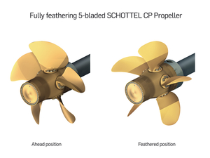
She was built with Controllable Pitch Propellers. This technology is fascinating!! It allows for very fine control of the ship’s motion.
An image of a CPP propeller with blades in two different positions to show the axis of movement. Image courtesy of Schottel website.
The CPP technology works by turning each of the propeller blades on its individual axis. In this way, the propellers never have to change the direction of spin, but instead the spin continues the same direction but the ship can come to a stop and then reverse direction. This differs from the fixed propeller system that is on the small launches. The Fairweather’s propeller blades are about 3 feet each in size for a total propeller diameter of 7 feet.
She also has a bow thruster which can be used in certain circumstances. The bow thruster enables the bow to move from side to side while the stern of the ship is static. It is essentially a propeller mounted into a tunnel/hole in the bow giving thrust perpendicular to the typical direction of travel. For a large ship like Fairweather, this is especially helpful when moving in and out of docking locations.
The next two technologies are of particular interest for my environmental science classes. Because the ship is often at sea for extended periods, it is necessary to make fresh water from the salt water. Typically Fairweather will take on ~16,000 gallons of water in port, but evaporators will be used to generate supplemental freshwater when it is needed.
This is the seawater intake for one of the evaporators.
The evaporators on Fairweather are flash (plate) evaporators and they can generate around 160 gallons of water per hour when operating optimally. The evaporators are running a distillation process by evaporating the water using heat from the boilers at a low pressure and then separating the freshwater from the brine (highly saline water). Because of the constant removal of salt from the water, the evaporators need to be cleaned often for best use.
This is one of the flash evaporators. Inside the pressure is lowered and the temperature runs at about 170 degrees F. While this is below the normal boiling point of water, the water will still vaporize and condense due to the low pressure
The brine is then discharged and the freshwater is added to the supply tanks. When leaving the tanks, it is pumped to higher pressure and further treated through filters and with UV light to kill off any bacteria that may have made it through. That water is stored in a hydropneumatic tank at high pressure so that water can be delivered to all parts of the ship without the need for continuously running pumps.
People eat and drink and then they pee and poop. They also like to shower and brush their teeth and wash their hands. They also need water to drink and cook with and to make coffee and tea. Obviously there is also a lot of gray water (sinks and showers) and black water (toilets) that is produced on a ship of this size carrying ~40 people. So what is done with all of it? Well, blackwater goes through the MSD (marine sanitation device) before it is discharged outside of 3 nautical miles from land. MSDs are standard on all ships and work similarly to land based sewage treatment on a much smaller scale. Gray water can be acceptably discharged as is in most places, but must be stored within NDZs or No Discharge Zones.
Guidelines for discharge
Other necessary technologies on the ship are the refrigeration system, the boilers and the generators. But I won’t go into all of those processes. It’s just amazing to me that there are so many things that must be accounted for on a ship if it will be at sea for multiple days!
Crew of the Day! Engineering
If you’re going to get pictures of the engineering crew, you have to find the rare times when lots of them are together… you can find a good group at mealtimes or when the ship is being docked and they all need to be on the boat deck! L-R: Sean, Kyle, John, Mick and RayL-R Sean, Connor, John, Mick, Alex, Eddie… and even with all my stealth, I’m still missing a couple from the group pictures!
The Engineering crew on this ship is a highly eclectic bunch! They are also a REALLY difficult group to get together for pictures. They have about a 40 year span in age and include folks from all over the world with a great diversity of backgrounds. There are several levels within the engineering crew. The entry level position is termed a wiper, next is an oiler, and then engineering utility, and junior engineer. These positions are unlicensed, analogous to enlisted positions in the military. The licensed positions are 3rd Engineer, 2nd Engineer, 1st Engineer and Chief Engineer. There are five licensed engineers on board right now and another six in the department who are oilers and junior engineers.
Anything that is mechanized, motorized, has an electric cable going to it, or needs to be oiled or lubed, those things all fall under the watchful eye of the Engineering crew. One of the young 3rd Engineers, Connor (nicknamed Titan because he really is giant) also describes them overseeing “Hotel Services” – plumbing, lighting, heating & cooling. The crew keeps a 24 hour watch whenever the ship is underway, and can take over aft steering if something were to fail with the bridge steering. They are also on watch whenever the small launches are being deployed or replaced to their cradles. If the bow thruster is being used, a crew member will also watch to see that it engages properly for use.
The well-being of the ship is in the hands of the Engineers and therefore the Chief Engineer reports directly to the Commanding Officer (where all other department heads report to the Executive Officer). The CO and the Chief Engineer really share the task of running the ship, but ultimate responsibility lies with the CO.
Personal Log:
The food! OH MY GOODNESS!!! The food on Fairweather has been terrific. There are two amazing cooks here currently. Tyrone, who is the Chief Cook, has been with Fairweather for 5 years. Prior to that, he cooked for the Navy. Kathy is the Chief Steward (which means she is in charge of the kitchen and develops the daily menus) and has been with NOAA ships cooking in some capacity for almost 20 years! You’ll learn more about her in my next blog… The Interview Issue!
So, here’s a sampling of what’s been on the menu since I’ve been here: Prime Rib, Lobster, Argentinian flap steak with Chimichurri, Halibut with some crazy good pesto type sauce… I am going to leave the ship about 10 pounds heavier than when I got here. So, this is not what you always get on NOAA ships, but this particular pairing of Kathy and Tyrone makes some serious magic!!
After spending a few days observing what happens in the Acoustics lab and listening to our Chief Scientist Rebecca (RT) Thomas and acoustician Julia Clemons brainstorm aloud, I had one overriding question…”How do you decide when to fish?”
I asked RT this question and it is a multi-factored decision for sure, but seems like the decision could be broken down into 3 parts: what we see, what we know and what is currently happening.
What they see when deciding to fish or not is an echogram created by three acoustic sounders on the ship that send out 3 different frequency wavelengths. The image shows a relatively low frequency 18 kHz, 38 kHz, and a longer wavelength of 120 kHz. Keep in mind that sound travels faster in water than on land so this is a great way to gather information while being minimally invasive to the marine environment.
Bridge of Bell M. Shimada. The 3 screens we watch during a AWT trawl for Hake.
The backscatter, sound that scatters off of an object or its echo, on the echogram is what they look at to determine what marine life is on the transect we are scouting. As the sound wave bounces off of material in the ocean be it rock, flora or fauna it will create a spot or colored pixel on the echogram. Hake has a particular “look” of backscatter. When the echogram shows this particular hake sign we move in the direction of fishing.
Of course they only know what “hake sign” is because of gathering evidence throughout the course of this multi-year survey. During this survey they have created a huge reference database of hake sign and sign of other integral species to the hake’s environment, for example Euphausiid sp., one of the hake’s favorite food. RT and Julia have both interpreted many echograms and fished to confirm the identity the organisms that created the sign. They are able to rule out images on the echogram until they find the backscatter that most resembles what they have historically experienced as hake.
The third part of this decision making process is the most variable…what is currently happening. As the boat travels and the sounders are sending out the trio of wavelengths an image of the ocean shelf is created. The scientists are able to see topography and measure the depths of the shelf’s different contours. The Shimada is a 209 foot long boat weighing over 2,400 tons. When deciding to trawl for hake that we suspect are present because of backscatter sign in the echogram the scientists and Commanding Officer always consider the depth to bottom, contours, wind and the maneuverability of the ship. Deploying the Aleutian Wing Trawl (AWT) net to catch hake is a task that involves cooperation and communication between the deck crew, Boatswain, bridge officers and the Chief Scientist. When RT sees a sign on the echogram that she wants to fish, she and Commanding Officer Kunicki quickly discuss the approach, wind direction and depth to get an idea on how the net will be affected and how close the ship can get to the exact sign that she wants to sample.
This is my bare bones description of the process that goes into deciding when to fish on Leg 5 of the Pacific Hake Survey. Stay tuned to see what we learn from comparing the echogram of sign to the actual yield from the AWT fishing net.
This ship is filled with kind, creative and industrious people. I am reminded of this constantly and appreciate this often. To me it is astounding to consider all the work and thought that is involved in a fifteen-day research survey at sea. This is a science survey so there are specific tools, computer programs and labs that must run well. To me, coming in with a science focus, this is most obvious. What I am blown away by are all of the additional layers that work together to make science even possible on this successful voyage. There are several teams at play: engineering, technology, deck, science and the bridge officers. Engineers are constantly maintaining engines, generators (this ship has 4), plumbing, ventilation and so much more. I had a tour today with Engineering Chief Sabrina Taraboletti that I am still trying to process through.
Technology is handled by one person on this ship. He maintains and trouble shoots computers in the acoustics lab, the bridge, the chemical lab and even found time to help maximize signal for the Fantasy Football draft. The deck crew is as versatile as anyone on this ship. We have two types of nets that we fish with. The deck crew is responsible for getting the nets out to fish and back in with the catch. Way easier said than done when we are talking about over a ton of weight with net, camera, chain, and doors. On top of all their other responsibilities many of the men in the deck crew have been helping out in the galley (kitchen) on this leg of the hake survey. Larry is the chief steward (chef) on board this leg and he typically has someone working with him but not on this leg of the Survey. So in addition to working their 12 hour shift, many of the deck crew have been working with Larry to prep food, clean up the mess (dining area), do dishes or even create their own personal specialties for dinner. We have been spoiled by Matt’s rockfish, Joao’s fresh salsa and soups and our Operations Officer Doug’s amazing BBQ. Liz and I even got to help out and make some donuts with Larry. Eating is great on the Shimada!
Liz and OCB making the donuts – thanks for the lesson Larry.
The Shimada team is rounded out with the bridge crew made up of 4 officers. The officers on a NOAA ship have a foundation of science knowledge and extensive nautical training. Before we go fishing I get to participate in the marine mammal watch up in the bridge. As I look for whales, dolphins and other marine mammals near the boat I can listen to the Captain and officers working their magic. We have had an incredibly smooth trip thus far which I credit to our Officers and of course Mother Nature.
Did You Know?
Who is this?
Crazy cool catch of the day…can you figure out what type of fish this is?
Here is a clue…they have specially adapted cells called photocytes that create light producing organs called photophores. The photophores run along the sides of the fish and help them to lure prey and attract mates.
Viperfish live in the deep ocean and migrate vertically as the day goes on in order to catch prey. They typically live around 1,500m (4,921 ft) and in the night will end up around 600m (1,969 ft) at night. This particular fish appears to have photophores along its mouth but it is difficult to be 100% sure from this specimen.