Yaara Crane: Maritime Careers, July 3, 2013

NOAA Teacher at Sea
Yaara Crane
Aboard NOAA Ship Thomas Jefferson
June 22 – July 3, 2013

NOAA GG
Along with us in port, was the Gordon Gunter.

Mission: Hydrographic Survey
Geographical area of cruise: Mid-Atlantic
Date: Wednesday, July 3, 2013

Latitude: 36.85°N
Longitude: 76.30°W 

Weather Data from Bridge:
Wind Speed:  4.80knots
Surface Water Temperature: 25.35°C
Air Temperature:  26.60°C
Relative Humidity: 81.00%
Barometric Pressure: 1023.19mb

Norfolk is a major naval base. We passed by this aircraft carrier with a plane sitting on its deck.

Science and Technology Log

When I began interviewing some of the individuals on board, I knew that I could not talk to all of the 30+ people on board. Here is a snapshot of some of the non-scientific personnel on board, and the important work that they do each day.

Chef Dave
Chief Steward Dave is in his chef whites in the galley.

David Fare has been working for NOAA for eight years, and you definitely want to stay on his good side. As Chief Steward, Dave is in charge of the most important aspect of life aboard a ship – food! Dave has spent the majority of his life at sea; he worked for the Navy for over 30 years before retiring, and then joined NOAA to get back to sea. As Chief Steward, his major duties include buying food, keeping track of the ship’s food stores, and maintaining a nutritionally balanced menu. The menu he creates is compiled from various recipes, cookbooks, and training he has attended over the years. There are quite a few regulations that he must follow to make sure everyone has the opportunity to have a healthy meal, but he must also go above and beyond to work within the bounds of any dietary restrictions. Dave’s meals must accommodate vegetarians, noted allergies, and low sodium for people with high blood pressure. His major advice for anyone seeking a position in the culinary field is to get experience, and attend a culinary school.

Anthony (Tony) Teele has also been working for NOAA for 8 years, the past five of which have been on the Thomas Jefferson. Tony is both the Medical Person in Charge (MPIC) and a Seaman Surveyor. As the MPIC, Tony has a medical background, specifically in clinical psychology and youth counseling. When I was feeling seasick, Tony was the guy checking my blood pressure and making sure that I kept hydrated. He was required to take a course to make sure he was prepared for general medical needs like basic first aid, CPR, and simple sutures. Tony hopes to use his medical skills in his future career endeavors.

As a Seaman Surveyor, Tony has many other duties. First off he explained how deckhands are ranked from entry level to the top: General Vessel Assistant, Ordinary Seaman, Able-bodied Seaman, Seaman Surveyor, Boatswain Group Leader, and Chief Boatswain. The Chief Boatswain on the TJ is the longest serving member of NOAA on the ship and an expert in his field. Tony’s duties include being Coxswain (abbreviated “Coxn”) on survey launches, being a helmsman on the bridge, operating various heavy machinery on board, and keeping the decks in top shape. He loves that NOAA gives him the opportunity to travel, learn, and provide stepping stones for his future.

My final interview was with GVA James Johnson (JJ). I found out early on that JJ attended Mount Vernon High School, just down the road from where I teach. After earning his GED and serving for 10 years in the Navy as an Aviation Support Equipment Technician, JJ made the switch to NOAA. He loves the idea that he is working for something bigger than himself and not stuck at a 9-5 job. Every day is an adventure as he learns his way around his duties. JJ is currently doing a lot of learning while he works. I have observed him spending hours on the bridge learning how to be a helmsman. Tony and the Officers help to keep a close eye on JJ while he is at the helm learning his new skills. His advice to people who want to be a GVA is to be proactive and seek out training. JJ appreciated the freedom that NOAA employees have to augment on different ships, and loves the excitement each new day brings.

Tony and James
Tony (left) and James (right) are on the bridge during their watch.

I spent at least half an hour speaking with each person, and the pride they all have in their jobs was something they all conveyed. Working on a ship is more than a job; it is a lifestyle that they have chosen. These men and women spend months of their lives away from their families each year, working to support NOAA’s mission. Kudos to you all, and thanks for making time to talk to a Teacher at Sea.

Norfolk radar
Norfolk is the third largest port in the country. The radar helps to navigate through this busy waterway.

Personal Log

We have made it back to Norfolk, and everyone is quickly taking the opportunity to celebrate the 4th on their own terms. This is a rare opportunity to be home for the Fourth of July holiday, and we have people going to areas like the Carolinas, Philadelphia, Seattle, and Cancun. Safe travels to everyone! The TJ will be in port for maintenance until mid-August before returning to the waters of the Delaware Bay. Their work for this summer is nowhere close to done, and I wish them all smooth sailing. For my future, I hope to be able to take a group of students on a field trip to Norfolk so that they can see first-hand where I lived for two weeks. I have also extended an invitation to members of the TJ that want to share their experiences with any of my classes. This was an exciting adventure, and I hope it is just the beginning of my interactions with NOAA. Blogging has been a new experience for me, so thank you to everyone who has been following my adventures.

Did You Know?

NOAA Corps Officers have no fewer than eight different uniforms that they must maintain throughout their career. The ship can also be dressed out for the holidays, and the TJ will be flying its flags in honor of the 4th of July.

TJ ship colors
The ship colors have been hoisted up the mast. They identify the ship by spelling the letters Whiskey Tango Echo Alpha

Yaara Crane: Scientific Careers, July 1, 2013

NOAA Teacher at Sea
Yaara Crane
Aboard NOAA Ship Thomas Jefferson
June 22 — July 3, 2013

TJ Chiefs
The people in charge of the TJ. From left to right: XO, Chief Steward, Chief Engineer, CO, and Chief Boatswain (front).

Mission: Hydrographic Survey
Geographical area of cruise: Mid-Atlantic
Date: Monday, July 1, 2013

Latitude: 38.81°N
Longitude: 75.05°W 

Weather Data from Bridge:
Wind Speed:  21.77knots
Surface Water Temperature: 22.16°C
Air Temperature:  22.80°C
Relative Humidity: 98.00%
Barometric Pressure: 1012.61mb 

Scientific Careers Log

During my time aboard the Thomas Jefferson, I have heard dozens of personal stories from individuals that come from all walks of life. I spent the past few days sitting down with a variety of these people to interview them about how they ended up a critical part of this ship. The following is just a short summary of my long conversations with each of these people. I found so much to write about, that today’s log will be about scientific careers, and tomorrow’s will focus on the non-scientific careers.

Of course, I had to begin my interviews with the man in charge: Commander Lawrence Krepp. CDR Krepp has been a NOAA Corps officer for over 20 years, and CO of the TJ since April of 2011. He particularly enjoys working on hydrographic ships, because they are the only ones in the fleet in which the CO is also the Chief Scientist. His background includes a degree in marine biology and work with the National Undersea Research Center.  In addition to saving him from a meeting each day, the major perk to being Chief Scientist is that he is able to work much more closely with the FOO to accomplish the objectives of the science party while maintaining supervision of all of the ship’s operations. CDR Krepp is able to spend his mornings walking around the ship and checking in on the bridge, then the rest of his day is spent immersed in reviewing survey work and other administrative duties.

QOD from CO
The CO puts a nautical trivia question in the night orders for his officers. He then checks their answers the next day.

On a more personal level, the CO mentioned that he wished he had more time to really work with the officers on their skills. CDR Krepp mentioned that he minored in education when he was in college, so it seems a little bit of the teacher still remains. Turnover on ships is very high because officers alternate every 2-3 years between sea and land assignments, therefore he will try to improve knowledge around the ship through spontaneous questioning on various scenarios that could occur. However, he always keeps an eye on the ship’s navigation systems to make sure the ship is safe and secure. If there was one aspect of his ship that the CO could change, it would be to improve the environmental treatment of the various waste streams on the TJ. An independent energy audit of the Thomas Jefferson was conducted in 2010, and CDR Krepp hopes to make improvements to the ship during his tenure as CO. Finally, the CO will do various things around the ship to help boost morale. The people that work on the ship give up a lot of personal freedoms, especially time with family, so the CO participates in some of the team-building around the ship. For example, he consented to have his hair cut by the winner of a ship-wide raffle. Proceeds from the raffle go directly back to planning events that can happen when at a port of call, such as going to a baseball game. Thanks for the interview, Captain!

Next in line was Lieutenant Commander Christiaan van Westendorp, otherwise known as the XO. The XO actually earned the rank of Lieutenant during his six years as a Navy Officer, a portion of which was spent on a nuclear-powered Navy submarine. Navy command structures do not generally transfer directly over to the NOAA Corps, so the XO had to spend nearly an additional year as an Ensign before being given his Lieutenant rank with NOAA. He spent two years as a FOO, and then was hired as XO of the NOAA Ship Ferdinand R. Hassler before coming to the TJ in November of 2012. LCDR van Westendorp will be on the TJ until the end of 2014, be given a land assignment for a few years, and then will most likely go to his final sea assignment as the CO and/or Chief Scientist of a NOAA ship. The XO is quick to point out that his career path is atypical of most NOAA officers, and he has been fortunate to be able to spend almost his entire NOAA career based out of Norfolk.

The XO is the main administrator, safety officer, and human resources officer on the ship, among other duties. These tasks involve a lot of paperwork, but also a lot of personal skills to work with any conflicts that might arise on the ship. His favorite part of his job is walking around the ship to keep in touch with everyone, and finding new challenges to tackle every day. LCDR van Westendorp echoes the opinion of many of the people I interviewed who just can’t get enough of the dynamism of life aboard a ship. Another aspect of the dynamism of the job is the exciting locales in which he has served. Since joining NOAA in September of 2005, the XO has had the opportunity to work in exotic locations such as Belize, Barbados, Suriname, Tahiti, and Hawaii. Thanks for the interview, XO!

ship store
I just bought a T-shirt from the ship store. Ensign Steve is in charge of keeping the store stocked and organized.

Working my way down the NOAA Corps Officers brought me to the second-newest officer on board, Ensign Steve Moulton. Ensign Moulton spent nine years in the Coast Guard, and has had to start over working his way up in the NOAA ranks. Right now, he feels that he is in a very heavy learning period of his career. Although he majored in an environmental field in college, he still had to attend hydrography school to learn the complex software and details of the ship’s work. Additionally, he is learning his way around a lot of collateral duties such as being the morale officer, the navigation officer, and running the ship store. Together with 8 hours of watch and processing hydrographic data, he is kept incredibly busy.

The major lesson that Ensign Moulton has internalized is to learn from your mistakes. Conditions on a ship, particularly while on the helm, change very quickly. He feels supported to spend time improving his skills, and has learned that any corrections from senior officers should only come once! Even so, Ensign Moulton enjoys the camaraderie of the ship, and being fortunate enough to spend his career on the water. He grew up in Rhode Island, and feels very connected to life at sea. Thanks for the interview, Ensign!

PS - James
James and I are looking at side scan data. He is pointing at a contact that may be a wreck.

My final scientist interview actually spends very little of his time at sea. James Miller, Physical Scientist, spends about 6-10 weeks on various East Coast NOAA ships throughout the year. He has worked for NOAA for three years, and is based out of NOAA’s Norfolk office. James joins the TJ and the Hassler for short periods to augment their scientific work and support the survey department. James normally spends his time on shore conducting quality assurance on the surveys that come directly from NOAA’s fleet of hydro ships and hydrographic contractors. He will compile these surveys into preliminary charts that will eventually be sent off to cartographers. James has picked up the knowledge for this career through his degree in Geology, an internship with NOAA arranged through Earth Resources Technology, and on-the-job training.

Although most of James’s job occurs behind a desk, he has had the opportunity to participate in a few more exciting NOAA ventures. For example, during the Deepwater Horizon crisis in the Gulf of Mexico, James was tapped to augment on the Gordon Gunter. He has also been asked to augment on assignments to reopen major ports after large storms and hurricanes. These opportunities generally come following emergencies, so James may be asked to report to a ship with only 24 hours’ notice. Finally, as others have said, James’ favorite part of working for NOAA is the dynamism of the field. James feels that he is in a steady learning process as the field of hydrography continues to improve in technological capabilities and scientific methods. Thanks for the interview, James!

Personal Log

It is getting to that time where we will be headed to Norfolk soon. I have been growing steadily accustomed to life at sea, and am excited to share everything that I have learned. I think the major lesson I have taken from this experience is one of creativity. If you don’t look past what you have learned, you may never know what other opportunities exist. As a teacher, I also agree with the idea of dynamism being a huge motivation in a career. Every morning that I wake up, I have new lessons to teach and challenges to address. I hope to keep that perspective and sense of adventure when I return to my classroom in the fall.

Did You Know?

The nautical charts created by NOAA are available in digital format for free public use. Hydrographic data is collected by NOAA ships, as well as with the cooperation of the U.S. Coast Guard, the Army Corps of Engineers, and the U.S. Geological Survey.

Yaara Crane: Engineering a Floating Town, June 29, 2013

NOAA Teacher at Sea
Yaara Crane
Aboard NOAA Ship Thomas Jefferson
June 22, 2013 – July 3, 2013

helm
My roommate, Ensign Kristin, is teaching me how to steer at the helm.

Mission: Hydrographic Survey
Geographical area of cruise: Mid-Atlantic
Date: Saturday, June 29, 2013

Latitude: 38.81°N
Longitude: 75.06°W

Weather Data from Bridge:
Wind Speed:  13.50 knots|
Surface Water Temperature: 22.61°C
Air Temperature:  23.30°C
Relative Humidity: 87.00%
Barometric Pressure: 1001.38mb

TJ sunset
Sunset over the bow of the Thomas Jefferson.

Science and Technology Log

At any given time, the Thomas Jefferson is home to about 30-40 individuals. These individuals come from all walks of life to become deck hands, engineers, stewards, scientists, or officers. Yesterday, I spent a couple of hours with Chief Engineer Tom learning about how his team of engineers works to keep this home afloat and functional. There are currently 4 licensed engineers, and 3 QMEDs (Qualified Members of the Engine Department) aboard the TJ.

engineering console
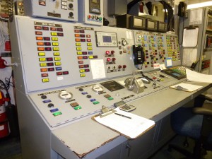
The engineering control console keeps and eye on all of the mechanics of the ship. If the bridge loses control, the engineers could steer the ship from here!

How do you become an engineer on a NOAA ship?  There are two routes to becoming an engineer on a NOAA ship. If you wanted to start working immediately aboard a ship, you could apply to start as an undocumented engineer. You are required to work 180 days at sea, pass a basic safety course, and then would become eligible to take a test to become a QMED. Another 1080 days would make you eligible to take a licensing test to become third engineer. From there, time and more licensing tests help you work up the ranks. There are a myriad of licensing tests that depend on the horsepower of the ship you want to work on. For example, most NOAA ships require the same license, but the NOAA ship Ron Brown has more horsepower and requires what is called an unlimited license. All licensing falls under the purview of the U.S. Coast Guard and various federal regulations. A different route to becoming an engineer involves attending a four-year program at a maritime academy. The maritime academy gives graduates the necessary skills to move straight into a third engineer position because it includes internships and semester at sea opportunities. The students from the academy must still take all of the same licensing tests. Clearly, engineers must have a great amount of knowledge as part of their toolkit no matter their background.

What really stood out to me was when Tom mentioned the fact that the word engineer comes from engine. The primary purpose of the engineer is to make sure that the ship has enough power for all of the tasks that happen around the clock. The TJ has two engines for propulsion and three generators for electricity that can be put online to boost the power output. When I was in the engine room yesterday, second engineer Steve was on watch and communicating with the bridge about having more power for their bow thruster. The bow thruster increases the maneuverability of the ship when it is slowing down, such as when anchoring. Steve made sure that Generator 1 was providing the energy needed for this particular task while Generator 2 was providing power for the rest of the ship’s needs. Overall, the Thomas Jefferson can hold approximately 198,000 gallons of diesel fuel, and uses about 1,500 gallons a day for all of its operations.

RO comparison
Can you tell which of these reverse osmosis machines is working, and which one is offline?

Most of the engineering equipment comes in duplicate just in case anything breaks down. For example, there are two reverse osmosis machines whose purpose is to turn seawater into potable water. One of them is currently down, so it is imperative that we have a second aboard. Reverse osmosis is the process by which seawater is pushed through a semi-permeable membrane in order to filter out the solutes, and only allow the water solvent through. The solute (sea salt) can then be dumped right back into the ocean. The water that is collected must be chlorinated before use, but will then go on to the galley, bathrooms, laundry, etc. The TJ can store around 21,500 gallons of freshwater and uses about 2,500 gallons of fresh water a day.

saline_diagram
The internal workings of reverse osmosis. Image credit: http://www.nrdc.org/onearth/04sum/saline_popup.htm

When being built, NOAA ships are outfitted for water usage in different ways, and Tom is busy planning how to make the ship more energy efficient. The TJ does not have the ability to use and recycle gray water or sea water very efficiently. Some NOAA ships have the ability to use seawater in the toilets, but the TJ does not. Have you ever thought of how much water is used when flushing a toilet? Well, you might have to think of that if you live in a desert area, or on a ship! Tom will be able to reduce the amount of water used in each flush by about 1.4 gallons with a simple valve that he plans on installing when the ship is docked for some maintenance work this summer. If we assume that there are 35 people on board the ship, and each person flushes 5 times a day, then the TJ can save 245 gallons of water each day with just a simple upgrade. This amounts to a reduction in water use of around 10% a day!

Tom has thought through many other types of upgrades, most not so simple, to better put to use the resources on board. Instead of using reverse osmosis, some NOAA ships make water through an evaporator. An evaporator is a much more efficient way of creating water because it needs a reduced pressure and average temperature near 160°F. On ships that have evaporators, water is diverted into pipes near the heat of the main engine so that the waste energy created by the engine can be transferred to reduce the amount of energy needed in the evaporator.

Although I have a particular interest in wastewater treatment and energy usage, these are by no means the extent of the engineer’s tasks. They are also responsible for checking fuel levels, keeping the air conditioning running (crucial considering the heat generated by the servers required to hold all of the ship’s scientific data), maintaining a workshop, being the ship’s electricians, and much more. Finally, they also work to keep up the morale of everyone in this floating town.

 Personal Log

I am trying to keep myself busy learning about all of the aspects of the ship. It is difficult to throw myself into the data analysis because the CARIS program is so complex; however, I spend lots of time watching the scientists plug at it. I have also been spending a lot of time on the bridge where some of the officers have been letting me help to collect hourly weather data, and teaching me to take navigational fixes. It is interesting to see that even with all of the digital data, the bridge officers must still take time to read a wall-mounted barometer and interpret cloud formations in the sky. For navigation, the officers still need to know how to use a compass and protractor, which brought me back to 1998 and my days in geometry class.

I also love hearing travel stories from the many people on board. Keith, a deckhand, has travelled all over the world on a NOAA ship based in Hawaii. It motivates me to continue to find opportunities to expand my horizons and see the world. I hope that I can also motivate my students back at Annandale to get creative with their ambitions.

 Did You Know?

Officers must be on watch 24/7, even when at anchor. To help preserve their night vision after the sun sets, the bridge is stocked with red plastic squares which are mounted over the screens to help minimize glare from white light.

night vision
The monitors on the bridge at night.

Yaara Crane: My Morning on a Survey Launch, June 26, 2013

NOAA Teacher at Sea
Yaara Crane
Aboard NOAA Ship Thomas Jefferson
June 22, 2013 – July 3, 2013

survey boat on TJ
The survey boat is moving from its cradle on the deck of the TJ.

Mission: Hydrographic Survey
Geographical area of cruise: Mid-Atlantic
Date: Wednesday, June 26, 2013 

Latitude: 38.84°N
Longitude: 75.04°W

Weather Data from Bridge:
Wind Speed: 8.35 knots
Surface Water Temperature: 21.29°C
Air Temperature:  22.80°C
Relative Humidity: 82.00%
Barometric Pressure: 1011.36mb

hydro survey boat
The survey launch on its way
Todd and Yaara
I am talking with the HIC about the notations on the nautical chart for our survey grounds.

Science and Technology Log

As promised, today’s post is going to be about the Hydrographic Survey Launches. The Thomas Jefferson has two of these boats that are generally launched by 8:00am and return to the ship at 5:30pm. On Tuesday, my official role was Hydrographer in Training. I joined HIC Todd and Coxn Junior for a day of surveying on boat 3102. After a morning of seasickness, they returned me to the TJ around 11:30 to recuperate. However, I was still able to experience a little of what they do every day and the hilarious camaraderie between the two!

In general, the survey launches do the same work as the Thomas Jefferson, just on a smaller scale. The TJ can only drive on lines with a minimum depth of 30 feet, but the survey launches can go to a minimum depth of 12 feet which allows them to get much closer to shoals and the coast. Every morning, the launch survey teams have a meeting with the FOO and XO in the survey room to discuss logistics and safety. My boat was headed out to survey grounds on a new sheet near Cape May, New Jersey. Specifically, we were driving lines in the Prissy Wicks Shoal. This particular region has highly variable depths and created quite a challenge for the HIC and Coxn for two reasons: you cannot navigate in straight lines over shoals, and the shoals constantly change so you must drive slowly in case an area is shallower than charted.

HIC Todd
Todd is at his workstation in the cabin.

Todd has been a HIC for both the Rainier and the Thomas Jefferson. In this position, he was worked with many Teachers at Sea, and gave me lots of great resources to bring back to school. The HIC sits inside the cabin and makes sure that all of the equipment is working together and logging the correct data. Just like on the ship, he has an MBES, HYPACK, and POS-MV to help him do his job. However, unlike the ship, he does not have an MVP, and must launch a CTD every four hours to measure the sound velocity profile in the water column. Measuring the sound velocity profile is an important part of correcting the MBES data for improved accuracy. Remember, the equipment is very sensitive to changes in the water because the farther the sound waves travel, the more they are affected by changes in the density of the medium through which they travel.

Coxn
Junior is doing his best to keep us on the line

Junior’s job as Coxn is to work with the HIC to safely navigate the boat on the survey lines. The Coxn has a monitor controlled by the HIC to help him see the current chart and line. Junior gave me the opportunity to try driving, and I barely lasted 15 seconds before I was off the line! Tuesday was particularly complex because we were in a highly trafficked waterway, shoals appeared out of nowhere, and there was a very strong current around the cape. When another boat appears in the line, the Coxn must bring his boat to a standstill while staying on the line so that data collection does not have to stop. If the survey line goes over an area that is particularly shallow, a decision needs to be made about how to get around the shoal without hitting the bottom. A lot of good-natured yelling happens between the Coxn and HIC so that they can hear each other and be in constant communication.

Once the survey launch has returned to the main ship, the data is downloaded onto a server from which the hydrographers can move the data into CARIS. Eventually all of that data will be turned into a new nautical chart to help marine vessels maneuver through the waters.

survey lines
What looks like highlighting is the multi-beam data from the survey launches. The colors get warmer (red) as the depth gets shallower

Today’s Acronyms and Abbreviations (some old, some new)

HIC – Hydrographer in Charge

Coxn – Coxswain

FOO – Field Operations Officer

XO – Executive Officer

MBES – Multi-Beam Echo Sounder

MVP – Moving Vessel Profiler

HYPACK – Surprise, not an acronym! This is just the name of the software.

POSMV – Positioning Orientation System Marine Vessel

SSS – Side Scan Sonar

CTD – Conductivity, Temperature, and Depth

CARIS – Computer-Aided Resource Information System. This software allows scientists to process the data that comes from HYPACK. Hypack collects data one line at a time, while CARIS allows you to combine the lines into a new nautical chart.

Prissy Wicks
The chart of Prissy Wicks Shoal shows the extreme changes in depths in a very small area.

Personal Log

Well, my bout of seasickness started about half an hour into my time on the survey launch. I started off in the cabin with the HIC, and the swells in the water got to me immediately. I spent the rest of the time on the deck with the Coxn trying to keep my eyes on the horizon. Through it all, I still managed to get a glimpse of some dolphins playing in the swells and saw many different types of boats and ships sailing around. When I was returned to the ship, I immediately felt better. However, the medical officer took precautionary measures and measured my blood pressure (totally normal, as usual for me) and prescribed 1.5 Liters of water before bed for the night. I took a nice long nap, and woke up in time for a delicious vegetable casserole for dinner. I am feeling back to 100% today, and hope to stay awake tonight. The TJ runs 24 hour operations, so I will pop by the bridge and survey rooms to see what it looks like after dark.

emergency signal
This sign is placed in each room as a reminder of what to do in case of emergencies.

Did You Know?

While at sea, it is required to perform at least one safety drill a week. Today, we had a fire drill and an abandon ship drill.

abandon ship suit
As part of my safety orientation, I had to put on the survival suit. I think I need a smaller size…
muster
My assigned muster locations for emergencies.

Yaara Crane: Hydrography is Underway, June 24, 2013

NOAA Teacher at Sea
Yaara Crane
Aboard NOAA Ship Thomas Jefferson
June 22, 2013 – July 3, 2013 

Mission: Hydrographic Survey

SSS fish
The SSS looks like a fish on a line just before it gets lowered into the water.

Geographical area of cruise: Mid-Atlantic
Date: Monday, June 24, 2013 

Latitude: 38.81°N
Longitude: 75.10°W 

Weather Data from Bridge:
Wind Speed: 11.54 knots
Surface Water Temperature: 20.41°C
Air Temperature:  24.30°C
Relative Humidity: 86.00%
Barometric Pressure: 1018.16mb

Science and Technology Log

The plan of the day (POD) for today included launching two survey ships (also known as Hydrographic Survey Launches), fixing the MBES, and pulling up anchor. The survey launches must have at least two people aboard: the hydrographer in charge (HIC) and the coxswain. They go out most days collecting data from about 7:30am until 5:30pm. While the Thomas Jefferson (TJ) has been anchored, these small survey boats have still been able to go out and work. I will have more information about these smaller boats in my next post as I plan to go on tomorrow’s survey team to learn what these individuals do each day.

TJ FRB
The FRB is put into its cradle using the davit to lift it from the water.

We have been anchored just off the coast of Lewes, DE in the Harbor of Refuge since Saturday morning. The CO (commanding officer) paged me at 12:30 today to observe while we were heaving the anchor in. I was allowed to stand on the bow and lean over the side of ship to watch. Pulling up the anchor was excellent news because it meant that the equipment delivery had arrived and the data collection would be able to begin again. Just after the anchor came up, I watched the FRB (fast rescue boat) make its delivery and be lifted into its cradle by the use of davits overhanging the deck.

hydro monitors
The workstation by the bridge has 5 monitors working to make sure the hydrographers are getting clear data. The bottom right monitor shows the current sheet and line we are sailing on.

We then sailed for a while to make it to our survey grounds. The Thomas Jefferson collects data by sailing in specified lines through the ocean; navigating to the beginning of a line takes skill and practice. NOAA assigns survey sheets which are sections of water with hundreds of lines that have earned priority to be charted on a particular leg of a journey. It is imperative that the watch standers on the bridge keep the ship on its planned survey lines to ensure that the entire ocean floor in a specific sheet is covered.  If you follow the path of the TJ on NOAA’s shiptracker, you might be able to zoom in to see the TJ going back and forth along these lines that are spaced exactly 120m apart. The 120m lines are carefully determined based on the fact that the SSS can measure 75m in either direction. Due to the nature of acoustic imaging, the farther a sound wave travels, the worse its accuracy will become. Therefore, a 30 m overlap of the SSS data occurs with 120m line spacing and the farthest distances will be able to be analyzed twice. If you remember, the MBES sends out a swath or cone of sound waves, so it will never be able to reach the farthest parts of the lines without being in extremely deep water. If the SSS picks up irregularities towards the edges of the data, the entire ship will have to break course to sweep back over the area in order to collect MBES data on that point.

SSS image
The side scan sonar is doing its job showing us the sand patterns on the ocean floor. The black in the center of the image is the water column directly underneath the ship which cannot be imaged by the SSS.

Today was the first time that I really had the opportunity to see what this ship is all about, and I look forward to seeing what kinds of objects can be detected on the sea floor.

 Personal Log

 Yesterday, our kayak adventure around Lewes gave me the opportunity to chat with a lot more people about their backgrounds and roles on the ship. Although everyone is very welcoming, this is certainly a very busy vessel and I appreciated the time to talk with people when I knew I was not interrupting their work. I was buddied up with Eileen, a junior officer, and Steve, the second engineer. Eileen is the newest NOAA Corps Officer on board the TJ, and is in training for many different certifications. She and Charles, another junior officer, need to earn hours towards their FRB certification and spent some time driving the FRB on the ride back from kayaking to the ship. It is jet propelled and extremely responsive and maneuverable. I was able to drive it for a few minutes on my first day, and that thing can really move!

TJ menu
Today’s delicious menu selection

The mess area is still a very exciting area of the ship for me. Normally, I avoid the high school cafeteria but I just can’t get enough on the ship! It probably helps that I am only on the ship for a short amount of time, but so far I have been enjoying all of the food. The chef posts a menu every day, and meals are served at 7:00am, 11:30am, and 4:30pm. Outside of those hours, there is still food available in the form of a salad bar, ice cream bar, cold and hot drinks, cereal, and probably other things I have not yet discovered. All of these options are certainly a necessity because there is no take out or delivery in the middle of the Delaware Bay.

Did You Know?

 The anchor of the Thomas Jefferson weighs 3500 pounds. To clean off the mud from a dirty anchor, the ship will drag the anchor at surface level and let the running water of the sea do the cleaning.

TJ anchor
The anchor has been dragging in the water for several minutes. You can see that one side still has the mud caked on it from the ocean floor.
Yaara near anchor
I am in my safety gear as the crew begins to lift the anchor chain located behind me.

Yaara Crane: First Day Aboard, June 22, 2013

NOAA Teacher at Sea
Yaara Crane
Aboard NOAA Ship Thomas Jefferson
June 22, 2013 – July 3, 2013

Mission: Hydrographic Survey
Geographical area of cruise: Mid-Atlantic
Date: Saturday, June 22, 2013

Latitude: 38.81°N
Longitude: 75.10°W

Weather Data from Bridge:
Wind Speed: 10.27 knots
Surface Water Temperature: 20.59°C
Air Temperature: 20.60°C
Relative Humidity: 79.00%
Barometric Pressure: 1023.18mb

Science and Technology Log

The TJ
My first view of the NOAA ship Thomas Jefferson.

This morning I came aboard the Thomas Jefferson via small boat transfer from the pilot station dock in Lewes, Delaware. Since coming on board, I have been welcomed by so many people, toured the ship, had a safety training, cautiously drove the small boat around the Delaware Bay, and tried to learn some background about hydrographic surveys. That is quite a lot of new things to process in only 5 hours!

The major purpose of hydrography is to create a thorough imaging of the ocean floor, particularly to warn mariners of any obstructions or shallows. There is evidence that nautical charts showing depth have been in use since as early as the sixth century BCE, and can easily be created through the use of a lead weight and a string. These days, NOAA ships have much more high tech ways of surveying the ocean floor. The Thomas Jefferson spends most of its time at sea charting waterways and coastlines to ensure safe travels for both private and commercial mariners to be able to navigate safely. Priorities in a nautical charting mission are based on factors including: waterway usage rates, stakeholder requests, rates of change to the sea floor (both natural and anthropogenic), and age of the chart’s source. For example, a waterway to a port used by oil tankers would be very important to survey because the result of a tanker running headlong into an obstruction would be disastrous. After Hurricane Sandy hit the East Coast in October 2012, the Thomas Jefferson was assigned to survey the sea floor of New York City’s harbor in case of any new obstructions that might have been blown in undetected. No other ship was allowed to sail through the harbor until the Coast Guard received the new charts. So far this summer, the Thomas Jefferson has already spent countless hours surveying the area around Long Island Sound and the Delaware Bay.

To have a better grasp of the major scientific research that occurs on a hydrographic research vessel, I spent a portion of the afternoon speaking with Ensign Andrew Clos. Ensign Clos mentioned that the two most important tools for data collection are the side scan sonar (SSS) and the multi-beam echo sounder (MBES). These two tools work through the use of sound waves to collect both 2D and 3D data. The SSS and the MBES send sound waves which are reflected back to the ship and transformed into images analyzed by the scientists on board. The side scan sonar is towed by the ship in very carefully spaced horizontal lines to gather the initial data about the existence of any objects in the water. An acoustic image is created and analyzed for anything out of the ordinary, in which case the MBES is launched for further investigation. The MBES is hull-mounted to the ship and survey launches, and lets out sound waves in a 128° cone which much more accurately determines the depth and position of the object. The MBES can collect millions of data points in a day, which is converted into three-dimensional images.

side scan sonar from NOAA
This SSS image is of the wreck of the Herbert D. Maxwell. The white area to the upper right is called a shadow because the sonar cannot pass into that area. (Photo courtesy of NOAA)
mbes noaa
This MBES image shows a fuller picture of the wreck of the Herbert D. Maxwell. (Photo courtesy of NOAA)

The scientists aboard spend many hours sifting through the data, and correcting the data for differences in depth based on tidal flows and water data. Sound waves travel through water at approximately 1500 meters/second (m/s), much faster than the 340 m/s in air. However, differences in salinity and temperature can impact the accuracy of measurements. All of the branches of NOAA must work together to piece together the puzzle of the ocean floor.

Personal Log

Rehoboth Beach
Hanging out at the beach the day before getting aboard the TJ.

This has been quite a busy week for me, which has culminated in this spectacular adventure. Monday was our last day of final exams, and today I feel like that was a lifetime ago! I spent most of yesterday morning driving to Delaware, and was rewarded with spending the afternoon relaxing on Rehoboth Beach. As it turns out, relaxing is on the table for tomorrow, too. The TJ is waiting on a repair to the MBES, and will need to stay anchored close to port for at least one more day. Commander Krepp has allowed some of the members of the crew to arrange for a day out paddling and kayaking around the beach. Still, there is work to be done and safety to consider aboard a NOAA vessel, so even that excursion has to be carefully managed into two shifts.

Weather-wise, it has been a beautiful weekend. There is a slight breeze, but not enough to make waves worth mentioning. The TJ is also anchored just behind a breakwater which helps to keep waves at bay. All of this adds up to a very calm shipboard experience, with barely any feeling of rocking or swaying while aboard the ship. I have rarely suffered from motion sickness and hope to continue my good record throughout this cruise. No seasickness means I can make my way over to the ice cream bar for a little afternoon snack…

Did You Know?

Fossil remains of horseshoe crabs have been found spanning approximately the last 450 million years. They are called living fossils because they are some of the rare species that have survived extinction with little genetic diversity.

Horseshoe crab
The horseshoe crab is a living fossil found on Delaware’s shores.


Yaara Crane: Ready for Summer Adventure, June 10, 2013

NOAA Teacher at Sea
Yaara Crane
(Not Quite Yet) Aboard NOAA Ship Thomas Jefferson
June 22, 2013 – July 3, 2013 

Mission: Hydrographic survey
Geographical area of cruise: Mid-Atlantic
Date: June 12, 2013 

Personal Log

Riley
My adopted black lab puppy, Riley

Hi everyone! My name is Yaara Crane, and I live in Falls Church, Virginia with my husband and 5-month old puppy, Riley. I am in the last week of my 7th year teaching for Fairfax County Public Schools. I applied for the NOAA Teacher at Sea program for multiple reasons, including expanding my knowledge of chemistry into new applications that can be relevant to my students. One of the exciting things about going on a Mid-Atlantic cruise will be that I am studying our “backyard” ocean; how much more relevant can it get?  I read that part of this year’s mission is to investigate the effect of Hurricane Sandy, which certainly affected us here in Virginia. We lost school days to the hurricane, so it will be very educational to learn what happened to our coastline due to the hurricane.

When I was picking my major at the University of Maryland, I immediately chose chemistry and stuck with it all four years. I have always been enthralled by science and thought I would spend my life doing research. However; I found that when I added my second major in education, I couldn’t imagine the idea of being alone in a lab when I could be surrounded by people all day instead! This experience lets me have the best of both worlds for a couple of weeks. Hopefully my time spent at sea will help me teach my students to expand their horizons and really think outside the box about what life could look like after high school or college.

This past school year, I taught General Chemistry and IB Chemistry to a very diverse group of students at Annandale High School. The coolest part of being a chemistry teacher at Annandale? Our mascot is the Atom! We are located inside the Washington, D.C. capital beltway and have had our diversity recognized by a visit from Michelle Obama and the first lady of South Korea last year. I love having students from all parts of the world who bring fresh and unique perspectives to my classroom each and every day. Also, teaching IB Chemistry requires my students to work on an interdisciplinary collaborative project. This past year, we studied the sustainability of our local Lake Accotink. Maybe next year, we can use the resources that I will learn while at sea to expand our horizons from the lake to the bay or the ocean.

Andy in Belize
My husband, Andy, is too tall for the Mayan arch he is standing near. Also, notice the Maya didn’t use curved shapes for their arches.

Travelling is one of my greatest passions. From an early age, I was instilled  with the desire to travel because my family lives all over the world. I have cousins in countries that include South Africa, Israel, Australia, and Brazil. For my honeymoon in 2010, my husband and I decided we needed to explore a new culture and have physical activity inherent in every day so we booked a trip to Belize. On our trip to Belize, we climbed ancient Mayan ruins, canoed into a several miles-long cave with only a guide and one headlight, went ziplining, biked, and snorkeled. My favorite day was when we hiked through the Maya mountains to have a picnic and swim in a secluded waterfall. We also got a small taste of ecotourism and learned how to identify howler monkeys, allspice, St. John’s wort, and the give-and-take tree. This honeymoon inspired me to lead a group of 12 students to Costa Rica the next spring break where we participated in several similar activities, and added the ecotourism element of searching for native fauna and climbing to the Poás volcano. I think my favorite part of the volcano was seeing the cause and effects of natural acid rain so clearly, as opposed to the anthropogenic sources that surround me in a metropolitan area.

I hope to learn lots of new skills, both personal and scientific, when aboard the Thomas Jefferson. This experience will be a wonderful combination of science, teaching, and travelling. I am getting excited and a little stir-crazy as my students prepare for their final exams, and I prepare for my summer adventure!

Yaara in Belize
I am the perfect size for the Maya civilization based on their arch. My 5’0 height should be comfortable in the tight quarters at sea!