Christine Hedge, September 15, 2009

NOAA Teacher at Sea
Christine Hedge
Onboard USCGC Healy
August 7 – September 16, 2009 

Mission: U.S.-Canada 2009 Arctic Seafloor Continental Shelf Survey
Location: Chukchi Sea, north of the arctic circle
Date: September 15, 2009

MST2 Tom Kruger and MST3 Marshall Chaidez retrieve a meteorological buoy on September 14.

Weather Data from the Bridge 
Latitude: 730 22’N
Longitude: 1560 27’W
Temperature: 310F

Science and Technology Log 

The past few days have brought much change.  The depth of the ocean changed dramatically as we got closer to Alaska. The ocean went from depths of over 3500 meters to depths of less than 100 meters.  More birds are showing up and we are getting about 9 hours of darkness each day.  This morning at about 4 AM, the watch observed the Aurora Borealis and stars!!!  I am so jealous.

FOR MY STUDENTS: Why do you think we have more hours of darkness now? 

As we head home to Barrow, the science party is busily completing their “Cruise Reports” and making sure that their data is stored safely for the trip home.  Much has been accomplished on this trip:

  • 132 XBT deployments (measures temperature, depth)
  • 8 CTD deployments (measures conductivity, temperature, depth)
  • 5 Dredge operations and hundreds of pounds of rock samples collected and catalogued
  •  1 Seaglider deployed and retrieved
  • 2 HARP instruments retrieved and 3 deployed
  • 3 Ice buoys deployed
  • 8 Sonobuoys deployed
  • 9585.0 lineal kilometers of sea floor mapped
  • 1 METBUOY retrieved (meteorological buoy)

Coast Guard Marine Science Technicians  

MST3 Marshal Chaidez operates the winch during a dredging operation.

Science parties come and go on the Healy, each doing a different type of research.  A constant for all the scientific cruises is the good work done by the Coast Guard MSTs (Marine Science Technicians). Running the winch, taking daily XBT and weather measurements, working the dredge, and helping to deploy buoys are just some of the many tasks these technicians do. The scientists could not get their experiments done without the assistance of our team of MSTs.

MST3 Daniel Purse, MST2 Daniel Jarrett, MST3 Marshal Chaidez, MST2 Thomas Kruger and Chief Mark Rieg have done a masterful job of helping the science party accomplish their goals. I asked them to tell me a little about their training for this job. Each MST attends a 10-week training school in Yorktown, VA. Most of their training involves how to clean up oil spills and inspect cargo ships which means they are usually stationed at a port. Being assigned to a ship is not the norm for an MST.  But, because the mission of the Healy is specifically science, a team of MSTs is essential.

MST2 Daniel Jarrett rigging the crane.

Personal Log 

My commute to work is different lately. We have about 9 hours of darkness each day. It gets dark around midnight and stays dark until about 8:30 in the morning.  So, walking the deck to the science lab is a bit of a challenge at 7:45. It will be strange to drive to work in a few days! On September 16th, we will depart the Healy via helicopter if all goes according to plan.  It will be strange to be on land again.

We will be back in Barrow, AK on September 16th. I cannot believe that our expedition is almost over.  I have learned so much from the members of the science party and the crew of the Healy. They have been very gracious and patient while I took their pictures and asked questions. Now comes the task of sharing what I have learned with folks back home.  I know one thing for sure; the Arctic is no longer an abstract idea for me. It is a place of beauty and mystery and a place some people call home.  I hope to convey how important it is that we continue to study this place to learn how it came to be and how it is currently changing.

Jon Pazol and I next to the bowhead whale skull in Barrow. When we return to shore the bowhead hunting season will have started.

Thanks to the folks at NOAA Teacher at Sea, Captain Sommer, and chief scientists Larry Mayer and Andy Armstrong for allowing me to take part in this cruise.  You can be sure that I will be following Arctic research and the adventures of the Healy for many years to come.

Christine Hedge, September 14, 2009

NOAA Teacher at Sea
Christine Hedge
Onboard USCGC Healy
August 7 – September 16, 2009 

Mission: U.S.-Canada 2009 Arctic Seafloor Continental Shelf Survey
Location: Chukchi Sea, north of the arctic circle
Date: September 14, 2009

Dr. Hall standing by the hovercraft before it is inflated

Weather Data from the Bridge 
Latitude: 720 46’N
Longitude: 1580 24’W
Temperature: 350F

Science and Technology Log 

Doing science in the Arctic is challenging.  The weather is difficult, the ice is ever changing, and the expense of operating an icebreaker, aircraft, or helicopter is quite high.  So, how else can people get out onto the ice to study the ocean and the geology of the seafloor? One interesting project uses a hovercraft (think air hockey), which skims over the ice on a cushion of air. Using a hovercraft to study the most inaccessible places in the Arctic is not a new idea. But, Dr. John K. Hall, a member of our science party has taken this idea and run with it.   John has a long history of polar exploration under his belt. Including 13.5 months floating around the Arctic on a 90 square kilometer, 60-meter thick ice sheet known as Fletcher’s Ice Island (T-3) during the 1960’s. His latest project has been to purchase and equip a hovercraft to go where icebreakers cannot (areas of VERY thick ice).

Norwegian students parked on the ice doing research. The white tent protects the scientists while they collect data through a drill hole in the ice.

The hovercraft was completed in 2007.  She is called the R/H Sabvabaa, which is the Inupiaq word for “flows swiftly over it.”  This hovercraft was designed specifically for doing science in Arctic conditions. It is equipped with all the comforts of home and all the latest technology.  From this research platform scientists have access to echosounding and seismic equipment to study the sea floor.  They can also park the Sabvabaa easily on a floe, get out on the ice to drill, photograph, and collect samples from under the ice.  This small 40-foot vessel (it fits in a semi-truck container) has great potential as a way for scientists to collect data in heavy ice conditions.  For more information about the Sabvabaa check out this website.

Classroom on the Ice 

Could you imagine being one of the first people to ride the hovercraft over the pack ice?  Since 2008, 16 lucky Norwegian high-school students have had that honor.  A competition was held as part of the Norwegian International Polar Year (IPY) program.  This competition set out to find Norwegian students ages 14-18 who are interested in careers in polar geophysics. A pair of students and a pair of researchers worked from the Sabavaa for one-week intervals. During their time on the Sabvabaa, the winning students participated in geophysical, geological, and oceanographic studies on drifting ice. They also had 4 encounters with polar bears!  What a great opportunity for these students. If you are interested in the student blogs from these trips (which are written in Norwegian) do a Google search for Sabavaa and have Google translate them.

FOR MY STUDENTS: Remember, not all scientists work in labs wearing white lab coats!  Many researchers lead exciting and adventurous lives. 

Paul Henkart teaching Nikki Kuenzel and Christina Lacerda.

Personal Log 

As an educator, one of the best parts of this expedition has been to watch the mentoring that goes on. The scientists and professors in the science party have decades of research experience to share. It is not unusual to find one of these veteran Arctic explorers sharing their expertise with graduate students from the University of New Hampshire. Not only do these “mentor scientists” have great technical expertise. They are also really good at explaining complex ideas in a very simple way.   This has been wonderful for me since my background is in biology – so geophysics has been a challenge. The graduate students on board are not only learning science from the masters – they are hearing great adventure stories about past polar adventures before we had helpful technologies such as GPS and multibeam echosounders. Everyone on the Healy is in “learning mode”.  The Coast Guard crew, teachers at sea, scientists, and students are constantly asking questions and sharing expertise.

Christine Hedge, September 13, 2009

NOAA Teacher at Sea
Christine Hedge
Onboard USCGC Healy
August 7 – September 16, 2009 

Mission: U.S.-Canada 2009 Arctic Seafloor Continental Shelf Survey
Location: Chukchi Sea, north of the arctic circle
Date: September 13, 2009

Weather Data from the Bridge 
Latitude: 720 44’N
Longitude: 1560 59’W
Temperature: 350F

A Seasonal Ice buoy with a thermistor chain is deployed from the Healy. This buoy starts in open water and later may
A Seasonal Ice buoy with a thermistor chain is deployed from the Healy. This buoy starts in open water and later may freeze into the ice. This instrument collects ocean and air temperature data, barometric pressure data, and location data.

Science and Technology Log 

Buoys and Moorings And Gliders, Oh My!!! 
Exploring the oceans has a lot in common with exploring space.  NASA can send manned or unmanned missions into space.  Sending manned vehicles into space is more complicated than launching a probe or a telescope. The same is true for exploring the Arctic Ocean.  We can collect data on an icebreaker, manned with Coast Guard and science personnel or use instruments that can send back data remotely.  On this mission, many instruments have been deployed to send back data about the conditions in the Arctic. These instruments continue to do their work after the crew and scientists from the Healy have moved on.  Ice buoys, which float or freeze into ice floes, are one example.  The HARP instruments (High-frequency Acoustic Recording Package), which sit on the sea floor, are another.

A United States Navy team, under the supervision of Navy Commander William Sommer, has launched a very interesting instrument from the Healy called the Seaglider. We have been tracking its movements since it was launched on August 8th. The Seaglider collects information about the salinity, temperature, and optical clarity of the ocean. The Navy is interested in how sound travels through the oceans and this glider is an important tool for doing just that.

CDR Bill Sommer, AG1 Richard Lehmkuhl, and MST3 Marshal Chaidez deploy a Seaglider from the Healy in the Chukchi Sea. Data from the Seaglider will improve the performance, and aid in the evaluation, of the effectiveness of the ocean models in the Arctic. Photo courtesy of PA3 Patrick Kelley, USCG.

What makes the Seaglider unique is that instead of just drifting, it can be driven.  In fact, this instrument is directed via satellite from a computer lab in Mississippi!  The glider moves up and down in the water column and like an air glider it uses this up and down motion to move forward. It has a GPS and a radio so that it can communicate its location. The Seaglider deployed from the Healy in August was picked up today.

Final check of the Seaglider before it was launched.
Final check of the Seaglider before it was
launched.
The green dots indicate the path of the Navy Seaglider as it collected data in the Chukchi Sea.
Coast Guard and Navy personnel work together to retrieve the Seaglider on September 13.

Christine Hedge, September 9-11, 2009

NOAA Teacher at Sea
Christine Hedge
Onboard USCGC Healy
August 7 – September 16, 2009 

Mission: U.S.-Canada 2009 Arctic Seafloor Continental Shelf Survey
Location: Chukchi Sea, north of the arctic circle
Date: September 9-11, 2009

Positions 
From Latitude: 790 6’N/ Longitude: 1550 47’W
To Latitude: 780 3’N/ Longitude: 1590 41’W

Alex Andronikov labels and bags rock samples for further study.
Alex Andronikov labels and bags rock samples for further study.

Science and Technology Log 

Exploring the Unknown 
Geologically speaking, parts of the Arctic Ocean are some of the least explored areas on earth because they are often covered with thick ice. Geologists know there is an ultra-slow spreading center (where seafloor pulls apart) called the Gakkel Ridge.  They know where major features such as abyssal plains, plateaus, and ridges are, but the story of how this area formed is still the subject of much discussion. Where exactly are the plate boundaries in the Arctic?  Which direction are they moving?  Which forces formed the Arctic Basin?  These are great questions that geologists continue to investigate. In 7th grade we study plate tectonics.  Our textbooks contain maps showing where the plates are pulling apart (divergent boundaries), pushing together (convergent boundaries), and sliding past one another (transform boundaries). I had never noticed before this trip that clear plate boundaries are not shown under the Arctic Ocean.

FOR MY STUDENTS: There are some great animations showing plate movements at this site.

Looking Back in Time with Rock Samples 

Kelley Brumley and Alex Andronikov are geologists on board the Healy. They have been analyzing the data collected by the echosounding instruments to better understand the forces at work here. But what they have really been looking forward to is seeing what type of rock the seamounts, ridges, and plateaus below the Arctic Ocean are made of, and how these features were created.

Our first 2 dredge sites brought up muddy sediment and lots of:

  • Ice rafted debris: These are rocks that are frozen into ice that breaks from shore and carried out to sea. They can come from glaciers, or river deltas or any shoreline.  Some show glacial striations (scratches left behind by glaciers).
  • Coated sediments: These are crumbly, compressed mounds of sediment coated with a dark precipitate.
Dredge #2 was a muddy affair.  Using the hose, I helped separate the sediment from the rocks.  That’s me in the turquoise gloves!
Dredge #2 was a muddy affair. Using the hose, I helped separate the sediment from the rocks. That’s me in the turquoise gloves!

The next 3 dredges broke off rock samples from the steep slopes over which they were dragged. This was what the geologists were hoping for – samples of bedrock.  The rock samples that were dredged up show us that the geological history of the region is very complex.  Analyzing the chemistry and mineral composition of these rocks will help to answer some of the questions Kelley, Alex, and other Arctic geologists have about this part of the Arctic Ocean.  The rocks are cleaned, carefully labeled, and shipped to Stanford University, the University of Michigan, and the USGS (United States Geological Survey) for further study. Who knows, maybe the rocks that were collected today will help to clarify models for the geologic history of this part of the Arctic Ocean.

Personal Log 

On September 11, I was able to call my students in Indiana. Jon Pazol, (ARMADA teacher at sea) has an Iridium satellite phone that he graciously allowed me to borrow.  How fun to stand on the helicopter pad of the Healy and field questions from Carmel, Indiana.

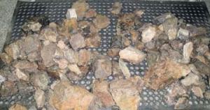
Rock samples from a successful dredge operation
Dredges sometimes bring up more than rocks and sediment. This arthropod came up with one of the dredge samples.
Calling my students.  You can see in the background that there is much more ice than a few days ago.
Calling my students. You can see in the background that there is much more ice than a few days ago.

Christine Hedge, September 7, 2009

NOAA Teacher at Sea
Christine Hedge
Onboard USCGC Healy
August 7 – September 16, 2009 

Mission: U.S.-Canada 2009 Arctic Seafloor Continental Shelf Survey
Location: Beaufort Sea, north of the arctic circle
Date: September 7, 2009

The empty dredge being lowered into the ocean.

Weather Data from the Bridge  
Latitude: 790 ’24N
Longitude: 1540 27’W
Temperature: 290F

Science and Technology Log 

Today we deployed our first dredge in hopes of collecting some samples of bedrock from the Arctic Ocean. A dredge is a basket made of metal chain link with a sharp edged bottomless tray on top. A wire cable connects this dredge to the Healy. Our echosounding instruments show us what the sea floor looks like. Maps reveal ridges, seamounts, flat abyssal plains, and raised continental shelves.  But, how did all these features form?  How old are they?  What type of rock are they made from?  What kinds of forces created this ocean surrounded by continents?  Where are the plate boundaries? Collecting rock samples will help us to answer some of these questions.

Sifting through the muddy sediment in search of rocks

FOR MY STUDENTS:  Can you predict what type of rock we might find by sampling oceanic crust?  Continental crust? 

Here is how dredging works:

  • The dredge is deployed over a seafloor feature with a steep slope. Lowering the dredge takes a long time as the huge spool of cable unwinds.  The top speed for the cable is 50 meters/minute.  Today, the cable with the dredge attached rolled out 3850 meters before it stopped. The Healy then moves slowly up the slope dragging the dredge behind.  The metal plates at the top of the dredge catch on rock outcrops as it is dragged up the side of the slope.   Pieces of rock and sediment fall into the basket.  The dredge is pulled up by the cable and lowered back on to the deck of the Healy. The dredge is dumped and scientists pick through all the mud and find the rocks.
Full dredge is safely landed on the deck of the Healy.

This first dredge brought back 400 pounds of mud and rock. Unfortunately, most was mud and only 10% was rock. Dredging is tricky business. Sometimes the dredge gets stuck and needs to be cut free.  Sometimes it collects only mud and no bedrock. We will be dredging at different sites for the next few days in the hope that good examples of bedrock will be collected.  The rocks we find will be catalogued and the chemistry of the rocks will be analyzed.  Hopefully, the rocks will help to answer some of the questions we have about the geologic history of the Arctic Ocean.

Personal Log 

Examples of rocks that were collected from our first dredge site.
Examples of rocks that were collected from our first dredge site.

When you work at a school, you get used to drills. Fire, severe weather, and intruder drills help to ensure that students and teachers will know what to do in the event of a real emergency.  The Coast Guard has drills each Friday to ensure the Healy will be ready to handle any emergency.  I have observed the crew practicing what to do in the event of fire, flooding, collision with another ship and various other scenarios. Last Friday, I was lucky enough to watch the crew in action.

The crew is suiting up for a Friday drill. Each member of the crew is trained to do many different jobs in case of an emergency.
Emergency medical situations are often a part of the training.  Friday’s drill included this mock-amputation of a crewmembers hand.  (Note the fake rubber hand)
Emergency medical situations are often a part of the training. Friday’s drill included this mock-amputation of a crewmembers hand. (Note the fake rubber hand)
If a compartment is flooded; the crew needs to do their best to contain the water.  This hatch is braced with wood and mechanical shoring.
If a compartment is flooded; the crew needs to do their best to contain the water. This hatch is braced with wood and mechanical shoring.

Christine Hedge, September 6, 2009

NOAA Teacher at Sea
Christine Hedge
Onboard USCGC Healy
August 7 – September 16, 2009 

Mission: U.S.-Canada 2009 Arctic Seafloor Continental Shelf Survey
Location: Beaufort Sea, north of the arctic circle
Date: September 6, 2009

Weather Data from the Bridge  
Latitude: 760 51’N
Longitude: 1380 54’W
Temperature: 300F

Rachel is showing me how the data we collect is processed.

Science Party Profile—Rachel Soraruf: Working For NOAA 

Are you the kind of kid who buys rocks when you visit a museum gift shop?  When you walk down the beach – is your head down searching for shells and stones?  If so, maybe you should consider studying geology in college.  Rachel Soraruf was one of those kids and now she works for NOAA. This year, NOAA sent her to the Center for Coastal and Ocean Mapping/Joint Hydrographic Center (CCOM/JHC) at the University of New Hampshire.   (That’s a mouthful!!)  At CCOM, she is a graduate student learning about the latest technologies in ocean mapping.

Rachel decided to major in Geology during her sophomore year at Mt. Holyoke College. According to Rachel, geology is a fun major because you get to “Do What You Learn”. In addition, there are lots of field trips that complement your lab and classroom work. Her next educational move was to earn a Masters Degree in Geosciences from the University of Massachusetts. By studying the geochemistry of a stalagmite for her thesis (final project) – Rachel was able to look back 5,000 years and determine climate changes that occurred over the centuries.

FOR MY STUDENTS: Have you ever gone caving?  Did you know stalagmites could reveal climate history? 

Ten-foot swells caused the ice floes to roll and bump. September 6th was the roughest ride of this trip.

Rachel has always liked the idea of “science with a purpose” – and NOAA offers her just that.  Her job is to plan the field seasons for NOAA vessels as they update the Hydrographic Charts of the waters around the United States.  People’s lives depend on these charts.  In order to safely navigate an oil tanker, cruise ship or fishing vessel  – up to date charts are essential.  The work she does makes a difference.  It truly is science with a purpose.

Personal Log 

Today we are in an area with thin ice and 10-12 foot swells.  It is an amazing sight to see the ice on the surface of the Arctic Ocean rolling with the swells.  The Captain reminded us to tie down our possessions so that cameras and laptops wouldn’t go flying off our desks.  It was good advice! I had not closed my file cabinet drawers completely and they were opening and closing as the ship rolled with the swells. I brought seasickness patches and pressure point wristbands to help me in case of seasickness and used them both today.

Christine Hedge, September 5, 2009

NOAA Teacher at Sea
Christine Hedge
Onboard USCGC Healy
August 7 – September 16, 2009 

Mission: U.S.-Canada 2009 Arctic Seafloor Continental Shelf Survey
Location: Beaufort Sea, north of the arctic circle
Date: September 5, 2009

Weather Data from the Bridge  
Latitude: 770 13’N
Longitude: 1370 41’W
Temperature: 290F

Science and Technology Log 

The two icebreakers are tying up side-by-side so that we can visit each other.

More Ways to Use Sound to See Beneath the Sea Floor 

Today we “rafted” with the Louis (the ships tied together side by side). I have been eager to see the science instruments that the Canadian ship is carrying. Once the ships were securely tied together we could just walk back and forth between them and tour the Canadian vessel.

The Healy has been breaking ice so that the Louis can have an easier time collecting data using seismic reflection profiling.  The goal is for the Canadian scientists to determine how deep the sediments are in this part of the Arctic Basin.  The sound waves their instrument sends out can penetrate about 1500 meters below the seafloor. Using sound they can “see” inside the earth – amazing!

FOR MY STUDENTS:  Remember your Latin/Greek word parts?  Look up “seism”. 

Seismic sled being hauled out of the water on the Louis. (Photo courtesy of Ethan Roth)

Here is how it works. The Louis steams forward at a low speed following in the path that the Healy has created through the ice. The Louis tows behind a weighted sled with 3 airguns suspended from the bottom.  This sinks about 10 meters below the water. Attached to the sled is a long tube filled with hydrophones (underwater microphones) called a streamer.  This streamer is about 400 meters long and stretches out behind the ship. It is best for the ship to move continuously so that the streamer will not sink or float to the surface.

FOR MY STUDENTS: Try to picture a 400-meter long “tail” on a ship. That is longer than 4 football fields. 

The airguns create a huge air bubble in the water.  When it collapses, it creates a sound pulse.  Two of the guns use a low frequency, which will penetrate deep into the sea floor but will create a low-resolution image.  The other gun uses a high frequency, which does not penetrate as deep but gives a high-resolution image.  The 16 sound recorders in the streamer record the echo created by these sounds reflecting from the sediment layers below the sea floor. The final product this instrument creates is an image of a cross section through the Earth. Scientists can look at these by observing this geologic history, the scientists are looking back in time. You can imagine that ice can cause lots of problems when a ship is towing a 400-meter long streamer behind it.  This is why we are working on collecting this data together.  One ship breaks, the other collects the seismic reflection data.

Steamer on deck of Louis. The blue steamer is out of the water and lying on deck when we visit the Louis.

Personal Log 

The crew has been looking forward to the two ships tying up together for the entire cruise.  Everyone is curious about the other ship. What are the staterooms like?  What is the food like? How is their bridge different from our bridge? And of course there is shopping!! Both of the ship stores had their best Louis and Healy gear ready for the eager shoppers.

After learning about the science instruments aboard the Louis, it was nice to finally see the seismic sled, streamers, and the computer nerve center where the seismic images are received. The ships are pretty different in their appearance.  The Louis is an older vessel and has wooden handrails, panels cover the wires in the ceiling, and there are some larger windows with actual curtains.  The Healy was built to be a science research icebreaker and so has many large spaces for science and looks generally more industrial. The Louis was an icebreaker first and some of their science spaces have been added later and are less spacious.

The bubble created by the airguns on the Louis. (Photo Courtesy Pat Kelley USCG)
The bubble created by the airguns on the Louis. (Photo Courtesy
Pat Kelley USCG)

Shopping and tours were fun but the most anticipated events of the day were the evening meal, contests and games.  The ship’s officers exchanged gifts in a formal presentation and then we had an amazing buffet together.  Personnel from both ships enjoyed scallops, halibut, salmon, shrimp, lobster, pork, beef, cheese, salads, and desserts. This was an exceptional meal and a great social event.  The idea of having Teachers at Sea (TAS) was a new one for most Canadians I spoke with and as we talked they seemed to think this TAS would be a great idea to stimulate interest in young Canadians about maritime careers.  The evening concluded with some friendly competitions between the crews and the science parties.  This entire event was a lot of work for the Coast Guard crews.  The science party really appreciates all the hours they put into planning this event!

Behind the wheel on the bridge of the Louis S. St. Laurent.

Christine Hedge, September 4, 2009

NOAA Teacher at Sea
Christine Hedge
Onboard USCGC Healy
August 7 – September 16, 2009 

Mission: U.S.-Canada 2009 Arctic Seafloor Continental Shelf Survey
Location: Beaufort Sea, north of the arctic circle
Date: September 4, 2009

Sometimes kittiwakes follow the ship.  I caught this one as it passed by the Healy.
Sometimes kittiwakes follow the ship. I caught this one as it passed by the Healy.

Weather Data from the Bridge  
Latitude: 780 12’N
Longitude: 1360 33’W
Temperature: 290F

Science and Technology Log 

Part of NOAA’s mission is to conserve and manage marine resources. To this end, the Healy has a Marine Mammal Observer (MMO) on board. Our MMO is Justin Pudenz. He collects data on any interactions we might have with marine mammals during our voyage.  Both the Louis and the Healy have observers on board.

Using a field guide to identify the Yellow Wagtail

Justin spends his time on the bridge of the Healy, binoculars in hand, notebook near by, always on the lookout for life on the ice or in the air. He lives in southern Minnesota when he is not on a ship. Justin tries to spend 6 months at sea and 6 months at home. He has been a fisheries or marine mammal observer since 2001. The company he works for is MRAG Americas.  NOAA hires observers from this company when they are needed. While on board the Healy, Justin spends hours each day watching for marine mammals and recording his observations.  The data he collects goes back to NOAA.

Justin has traveled to many bodies of water as an observer including the Pacific near Hawaii and the Bering Sea for fisheries observation.  His next mission will be on a crabbing vessel in mid-October. If you can picture the television show “DEADLIEST CATCH” – that is the type of vessel he will sail on. On a fisheries trip Justin will collect data on the species of fish caught, their sex, weight, length and other information NOAA needs, to understand the health of ocean ecosystems.  Justin grew up enjoying the outdoors and always knew a desk job was not for him.  He has a degree in Wildlife and Fisheries Science and has been lucky enough to find a job that gets him outdoors and is ever changing. 

A yellow wagtail has been seen from the ship in the past few days.  I wonder what this bird is doing so far out to sea - ideas?
A yellow wagtail has been seen from the ship in the past few days. I wonder what this bird is doing so far out to sea – ideas?

FOR MY STUDENTS: How are your observation skills?  Would a job at sea be a good match for you? 

I asked Justin what he has seen from the Healy. Our “trip list” follows. The farther away from land we get, the fewer species of birds we see. Most of these bird species were spotted before we hit the heavy ice.

The Marine Mammal Observer has seen these birds since we departed Barrow, AK: Pacific loon, Northern fulmar, red phalarope, long-tailed jaeger, Ross’ gull, Arctic tern, spectacled eider, pelagic cormorant, parasitic jaeger, glaucous gull, black-legged kittiwake, yellow wagtail.

The Marine Mammal Observer has seen these mammals since we departed Barrow, AK: bearded seal, ringed seal, Arctic fox, polar bear.

Personal Log

Many people have asked about the living spaces inside this ship.  It is an amazing vessel when you think about all that happens here.  The Healy is truly a floating city with 120 people on board.  Any function that your town does – this ship needs to do.  A city needs to clean water, sewage treatment, trash pick up, recycling, electrical power, food, shelter, and recreation.  All of these are provided for on the Healy. I have attached a few pictures of life on the Healy below.

Our bunk beds have curtains to keep out the 24-We each have our own desk and filing cabinet and hour sun. Note the stuffed polar bear. This was most important a porthole window! Notice the color a gift from Mrs. Campbell and Mrs. Taylor. outside – we are getting a few hours of twilight in the early morning hours.
This is the place where the science party relaxes,  plays cards, and watches movies.
This is the place where the science party relaxes, plays cards, and watches movies.
We each have our own desk and filing cabinet and most important a porthole window! Notice the color outside – we are getting a few hours of twilight in the early morning hours.
 The main library has computers for the crew to email friends and family and plenty of reading material.
The main library has computers for the crew to email friends and family and plenty of reading material.

Christine Hedge, September 3, 2009

NOAA Teacher at Sea
Christine Hedge
Onboard USCGC Healy
August 7 – September 16, 2009 

Mission: U.S.-Canada 2009 Arctic Seafloor Continental Shelf Survey
Location: Beaufort Sea, north of the arctic circle
Date: September 3, 2009

Weather Data from the Bridge   
Latitude: 780 34’N
Longitude: 1360 59’W
Temperature: 290F

Science and Technology Log 

Ethan Roth shows me the inner workings of a sonobuoy.

Low-Impact Exploring 

Some of my previous logs have talked about sound in the Arctic Ocean.  Sounds made by seals, whales, ice cracking and ridges forming, bubbles popping, wind, waves – these are the normal or ambient noises that have always occurred. As governments, scientists, and corporations explore the Arctic their presence will have an impact. Ships breaking ice and the seismic instruments they use to explore, add noise to the environment.  We call this man-made noise, anthropogenic noise.  Will these additional sounds impact the organisms that live here? Can we explore in a way that minimizes our impact on the environment?  The marine wildlife of the Arctic has evolved in an ocean covered by ice. But the ice is changing and the human presence is increasing.

Studies of other oceans have shown that more ship traffic means more background noise. In most regions of the Pacific Ocean the background noise has increased 3 decibels every 10 years since the 1960’s. The scientists on the Healy and the Louis are interested in minimizing their impact as they explore the Arctic Ocean.

Do No Harm – Step 1 Collect Data 

I am tossing the sonobuoy off the fantail of the Healy.

One of the ways we are listening to the noise that our own instruments make is with sonobuoys. These are devices that help us listen to how sound propagates through the ocean.  While the Louis is using airguns to collect seismic data – scientists on the Healy are throwing sonobuoys into the ocean to listen to the sound waves created by the airguns. Knowing how the sound waves from airguns travel through the water will help us to understand their impact on the environment. Sonobuoys are self-contained floating units. They consist of a salt-water battery that activates when it hits the water, a bag that inflates with CO2 on impact, a 400-foot cable with an amplifier and hydrophone (underwater microphone).

The data acquired through the sonobuoy are relayed to the ship via radio link. A receiving antenna had to be placed high up on the Louis in order to collect this data. Like many of the devices we are using to collect information, the sonobuoys are single use instruments and we do not pick them up after their batteries run out. After 8 hours of data collection, the float bag burns and the instrument sinks to the bottom. They are known as self-scuttling (self-destructing) instruments. The more we know about the sounds we make and how these sounds are interacting with the animals that call the Arctic home, the better we will be at low impact exploring.

Personal Log 

The float inflates as the sonobuoy floats away.

I’ve had lots of questions from students about the weather. For most of our trip, the air temperature has been around 270F and the visibility has been poor. A log fog has prevented us from seeing the horizon. We have also had quite a few days with snow and freezing rain.  Some of our snow flurries have coated the decks with enough snow to make a few snowballs and prompted the crew to get out the salt to melt the slippery spots. 

This past week we had some seriously cold days.  On September 1st, the air temperature was 160F with a wind chill of -250F. These cold days brought blue skies, sparkling snow, and beautiful crystals forming on the handrails, ropes and many other surfaces on the deck.

Ice crystals on a valve

FOR MY STUDENTS: Why do you think it is foggier on warmer days? 

As we travel south we are starting to get some sunsets and sunrises.  There are a few hours of twilight between the times that the sun dips below the horizon – but no true night sky.  One of the things I miss the most is seeing stars.  I look forward to seeing the Indiana night sky in a few weeks. But until then, the gorgeous sun over the Arctic will have to do.

As the seasons change and we travel south, the sun gets lower in the sky

Arctic snowball
Arctic snowball

Christine Hedge, September 1, 2009

NOAA Teacher at Sea
Christine Hedge
Onboard USCGC Healy
August 7 – September 16, 2009 

Mission: U.S.-Canada 2009 Arctic Seafloor Continental Shelf Survey
Location: Beaufort Sea, north of the arctic circle
Date: September 1, 2009

The path of the Healy through the ice with the Louis S. St. Laurent from Canada following (See it way in the distance?)

Weather Data from the Bridge 
Latitude: 800 26’N
Longitude: 1370 16’W
Temperature: 20

Science and Technology Log 

Why Are Two Icebreakers Traveling Together? 

All of the countries that have a coastline on the Arctic Ocean are trying to collect data to determine where their extended continental shelf (ECS) ends. One of the types of data needed is called seismic data.  Collecting this information involves towing a long (a kilometer or more) streamer behind the ship. It is difficult to do this well in ice-covered water.  So, the Canadians and the Americans are collecting data together. One icebreaker leads and breaks a path for the second following with the seismic streamer being towed behind.  For most of our trip together, the Healy has broken ice for the Louis S. St. Laurent. We are both collecting data – just different types with different instruments.

FOR MY STUDENTS: Can you name all the countries that have coastlines on the Arctic Ocean? Of which country is Greenland part? 

Why Do We Care Where Our Extended Continental Shelf Is? 

Close-up of the Louis S. St. Laurent collecting data behind the Healy

The oceans and ocean floors are rich with natural resources.  Some countries obtain much of their wealth from mining the oceans, drilling for oil or gas in the oceans, or from fish or shellfish obtained from the oceans.  Currently, a nation has the right to explore for and harvest all resources in the water and everything on or below the seafloor for 200 nautical miles beyond its shoreline. One nation can allow other nations to use its waters or charge oil companies for the right to drill in its seafloor and thus make money. But what if we could use resources beyond that 200-mile limit? That would add to a country’s wealth. If a country can show with scientific data that the continental shelf extends beyond those 200 miles they can extend their rights over:


1) The non-living resources of the seabed and subsoil (minerals, oil, gas)

2) The living resources that are attached to the seabed (clams, corals, scallops ) An extended continental shelf means a nation has rights to more natural resources.

FOR MY STUDENTS: Look at a map of the oceans. Can you find the continental shelf marked on the Atlantic coast of the United States? What types of resources can you think of that we get from the ocean and the seafloor? 

Where Exactly Is the Healy Going? 

The red line shows where the Healy has been. The yellow waypoints show where we might be after September 1, 2009.

Our trail looks random to the untrained eye but it does have a purpose.  We have been helping the Louis get good measurements of the thickness of the sediments on the seafloor.  You see there are certain features of the seafloor that help a nation identify its ECS.  One is related to depth. Another is related to the thickness of the underlying sediments.  Another is related to the place where the continental slope ends (the foot of the slope).  We have been following a path that takes us to the 2500-meter contour (where the ocean is 2500 meters deep) and following a path to measure the thickness of the sediment in the Canada Basin.  I was surprised to think that there was thick sediment on the seafloor in this area.  But, the Arctic is a unique ocean because continents surround it. It is more like a bowl surrounded by land.  As rivers have flowed into the Arctic over millions of years – layers and layers of sediment have covered the Canadian Basin.

FOR MY STUDENTS: Look at your maps again.  Find rivers, bays, fjords, that flow into the Arctic Ocean.  For More Information About The Extended Continental Shelf

Personal Log 

Erin Clark, Canadian Ice Services Specialist has been working with us on the Healy.

The U.S and Canada have been sharing personnel as well as sharing a science mission.  Coast Guard personnel and science party personnel have been traveling between the two ships via helicopter to share their expertise.  As the Canadian visitors come through our science lab and eat meals with us – we have had plenty of time to discuss science and everyday life. There has also been a longer-term exchange of personnel.  A scientist from the United States Geological Survey (USGS) has been sailing on the Louis since they left Kugluktuk, Northwest Territories. Dr. Deborah Hutchinson is on the Louis to provide USGS input to scientific decisions made during the cruise.

My roommate, Erin Clark, is a Canadian Ice Services Specialist.  Erin hails from Toronto, Ontario and is staying on the Healy to exchange expertise with the American ice analysts.  It has been interesting getting to know Erin and hearing the story of her career path.  She was one of those kids in school who just couldn’t sit still in a structured classroom environment.  Erin is a visual learner – and often had a hard time proving to her professors that she understood the material as she worked on her degree in Geography.  Where other students used multi-step equations, Erin used diagrams and often didn’t “show her work”.  NOTE TO STUDENTS: Do you know how you learn best?  What is your learning style?

Matthew Vaughan a Canadian geology student from Dalhousie University shows us pictures of the seismic gear on the Louis

Erin was lucky enough to have instructors that worked with her and now she is one of about 20 Marine Services Field Ice Observers in Canada. Luckily, she has found a career that offers lots of opportunities to move around. Some of her time is spent analyzing satellite photos of ice on a computer screen, some ice observing from a ship, and some ice observing on helicopter reconnaissance trips.  She communicates what she observes about ice conditions to ships; helping them to navigate safely in ice-covered waters.

FOR MY STUDENTS: What kind of skills do you think an Ice Specialist would need to succeed in their career? 

Christine Hedge, August 29, 2009

NOAA Teacher at Sea
Christine Hedge
Onboard USCGC Healy
August 7 – September 16, 2009 

Mission: U.S.-Canada 2009 Arctic Seafloor Continental Shelf Survey
Location: Beaufort Sea, north of the arctic circle
Date: August 29, 2009

Science Party Profile – George Neakok 

George Neakok (left) and Justin Pudenz watch for marine mammals from the bridge of the Healy.

George Neakok is on board the Healy as our Community Observer from the North Slope Borough. A borough is like a county government.  Except, since Alaska is so huge, the North Slope Borough is roughly the size of the state of Minnesota.  George acts as the eyes of the Inupiat (native people of the North Slope) community while on board the Healy. The Inupiat people are subsistence hunters. They live off the animals and plants of the Arctic and have a real stake in how other people are using the same lands and waters they depend on for survival. George spends hours on the bridge each day looking for life outside the Healy and noting any encounters the ship has with wildlife in general and marine mammals in particular. He is a resident of Barrow, Alaska (one of the 7 villages in the Borough) and has acted as an observer for 2 years traveling on 5 different expeditions. George says he was selected for the Community Observer job because he is a good hunter and has good eyes.  He is too humble.  His life experience has endowed him with fascinating knowledge about the ice, animals, and the Arctic world in general.  George can see a polar bear a kilometer away and know how old it is, how healthy, and what sex.

I asked George to share a little about his life and the kinds of changes he has observed in the Arctic. He has always lived in Barrow except for 2 years when he went away to Kenai Peninsula College to study Petroleum Technology. His dad died while he was away and so he returned home to help his mother.  He has worked in the natural gas fields near Barrow and expects to work in the new field southwest of Barrow in the future.  George has 7 children ranging in age from 20 years to 9 months.  His youngest daughter is adopted, which he says is very common in his culture. There are no orphans.  If a child needs a home, another family will take that child in.  Although his children are being raised in a world with cell phones and snowmobiles – they are still learning to live the way their ancestors have always lived.

Erosion on the coast of Barrow, Alaska is an ever increasing problem.

George and his community are a part of  both an ancient and a modern world.  With each season comes another type of food to hunt or collect. The Neakok family hunts caribou, bowhead whale, seals, walrus, beluga, and geese each in its’ own season.  They fish in fresh water and in the Chukchi Sea. They collect berries, roots, greens and eggs, storing them in seal oil to preserve them until they are needed.  Food is stored in ice cellars.  These are underground rooms that can keep food frozen all year round. The animals that are hunted are used for more than just food.  The Inupiat make boats from seal or walrus skin.  In Inupiat culture, the blubber, oil, tusks, baleen and meat are all useful in some way.  If one community has a very successful hunt, they share with their neighbors.  If a community has a bad hunt, they know that other villages will help them out.  Villages come together to meet, celebrate, trade and share what they have caught.  George says this is just the way it is.  People take care of their neighbors.

FOR MY STUDENTS: What can we learn from the people of the North Slope about community? 

A polar bear, spotted by George, travels over thin ice by spreading out his body weight.  (Photo courtesy of Pat Kelley USCG)
A polar bear travels over thin ice by spreading out his body weight. (Photo courtesy of Pat Kelley)

George has witnessed much change in his life.  He notes that the seasons are coming earlier and staying later. The shore ice used to start forming in late August but lately it has been forming in late September or early October. When there is less ice close to land, there are fewer animals to hunt.  Whaling off the ice is getting more and more dangerous. The ice is more “rotten” and camping on the ice during the hunt can be treacherous. In recent years, more and more hunters have lost their equipment when the ice gave way.

Erosion of the coastline is another recent problem.  Without ice to protect the shoreline the wave action eats away at the permafrost causing coastlines to collapse.  George has seen a coastal hillside where he used to sled – crumble into the ocean. Entire villages have been moved farther inland as the coastal erosion eats away at the land. George is hopeful that although the Arctic is changing fast, the Inupiat people and culture will handle these changes and continue to live and thrive on the North Slope of Alaska.    

Christine Hedge, August 28, 2009

NOAA Teacher at Sea
Christine Hedge
Onboard USCGC Healy
August 7 – September 16, 2009 

Mission: U.S.-Canada 2009 Arctic Seafloor Continental Shelf Survey
Location: Beaufort Sea, north of the arctic circle
Date: August 28, 2009

Weather Data from the Bridge  
Latitude: 840 10’N
Longitude: 1210 30’W
Temperature: 290F

Science and Technology Log 

Sick Bay on the Healy

What Happens If You Get Sick? 

The Sick Bay (medical clinic) on the Healy is the largest and best equipped in the Coast Guard. It has to be, since we are so far from land for such long periods of time.  We have a digital x-ray unit and a cardiac unit for diagnosis, defibrillation, and pacing an irregular heartbeat plus everything needed to keep a patient stabilized and pain free until they can get to a hospital. The Healy is also the only cutter with a permanent Physician’s Assistant (PA) on staff. The most serious medical issues our current PA has had to deal with on the Healy are broken bones and deep gashes. If a patient did have a life threatening injury, they would be kept comfortable until an aircraft could get them to shore. I spoke with Lt. Jason Appleberry (Physician’s Assistant) and HS2 (Health Services Technician) John Wendelschaefer who staff this important part of the ship and asked them about their jobs and their training for working in healthcare on an icebreaker.

Prevention Is the Best Medicine 

HS2 Wendelschaefer shows me Mr. Bones in Sick Bay

The busiest times in Sick Bay are when new people come on board with new germs.  When the crew has time on shore or new crew or science parties join the Healy – colds and other minor inconveniences crop up. The Coast Guard has strict rules about vaccinations for anyone spending time at sea and a very visible strategy to help prevent the spread of germs.  There are hand sanitizer dispensers in the mess (cafeteria) and elsewhere.  Anti-bacterial wipes are available in the gym to wipe down sweaty equipment.  The medical staff inspects the cooks and the galley like a Health Inspector would at a restaurant.  Sick Bay also has an incubator used to test the drinking water for contamination.  And last but not least, every Saturday, everyone cleans!  Heads (bathrooms), staterooms (bedrooms), and the rest of the ship are disinfected and made ready for inspection.  So kids, you have to make your bed and clean your room – even on an icebreaker!!

Profile of the Medical Staff 

I asked Lt. Appleberry how he ended up in this job.  As a young man his career interests included, doctor, paramedic, firefighter and other jobs that combined adventure with a curiosity about science and medicine.  In his words, he wanted to be – “that guy who shows up during a disaster to help.” After a few years of college he spoke to the Coast Guard and thought Coast Guard search and rescue would offer adventure and medicine all in one career.  He enlisted in 1991, and since then has traveled all over the country learning and serving.  Lt. Appleberry earned a Masters degree through the Coast Guard and has been able to use his training in clinics in Kodiak, Alaska and Hawaii and on various ships.

FOR MY STUDENTS:  Have you thought about what kind of career you would like to have? What do you enjoy doing? What activities drain you? What activities invigorate you? 

Part of the mission of the Coast Guard is search and rescue. If someone is hurt on a fishing boat or a pleasure boat is lost at sea, the Coast Guard is there to help. HS2 (kind of like an EMT for civilians) Wendelschaefer has also received his medical training through the Coast Guard.  His experience has been that the Coast Guard is a great place to be a lifelong learner.  There are lots of choices for career paths, tuition assistance, and constant on the job training.  For both men, the Coast Guard has been a positive experience.  They have traveled to and lived in exotic locations, and should they decide to leave the military – they have very marketable skills for the civilian world.

Personal Log 

This is a screen shot of our path as we hit our northern most point. The red line indicates the 840 parallel.

Today we hit our northern most point of the trip.  We were north of 840 and as they say, it’s all down hill from here!  This is the closest I will ever get to the North Pole.  Next week we will have a ceremony for all the folks on the ship who have crossed the Arctic Circle for the first time.  This summer I crossed the Tropic of Cancer (look that one up) when I went to Baja, Mexico and the Arctic Circle.  It was easy for me because I had air transportation.  Some animals make migrations like this every year!!!  The gray whale will swim from the Tropic of Cancer to the Chukchi Sea every year without the benefit of an airplane – AMAZING!

FOR MY STUDENTS: Look at a map. Follow 840 North and see where it goes.  Think of all the places you have traveled. How far north have you been?  Figure out your latitude. 

Christine Hedge, August 26, 2009

NOAA Teacher at Sea
Christine Hedge
Onboard USCGC Healy
August 7 – September 16, 2009 

Mission: U.S.-Canada 2009 Arctic Seafloor Continental Shelf Survey
Location: Beaufort Sea, north of the arctic circle
Date: August 26, 2009

Science and Technology Log 

This is what we see in the Science Lab of the Healy before the data is processed.  It is like a cross-section through the top 50-100 meters of the sea floor.  Here you can see it was flat and then climbed uphill.  The numbers represent round trip travel time in seconds.
This is what we see in the Science Lab of the Healy before the data is processed. It is like a cross-section through the top 50-100 meters of the sea floor. Here you can see it was flat and then climbed uphill. The numbers represent round trip travel time in seconds.

Is There a Bird in My Room? 

When I first got on the Healy, I thought there was a bird in my room.  Then I realized the chirp that I kept hearing every 9 seconds or so was not just in my room.  It got louder as I went down the ladders to the deepest part of the ship near the laundry. I found out that this chirp is the sound transmitted by the subbottom profiling system.  This instrument is being used on the Healy to collect data about the depth of the water and the nature of the sea floor. These subbottom profiler transducers are mounted on the hull of the ship. The “chirp” sound reflects (echos) off the bottom of the ocean and also reveals the sediment layers below the bottom.  This is one of the systems I watch on a computer screen when I am working.

Using Sound as a Tool to See Inside the Earth 

Sound is an amazing tool in the hands of a geophysicist, who is a person who studies the physics of the earth. The subbottom profiler uses a low frequency sound. Low frequency will penetrate further into the earth than the higher frequencies used by echosounders. This helps scientists to “see” about 50 meters below the surface, depending on the type of sediment (clay, sand, etc).  By looking at how the sound waves are reflected back to the ship, scientists can see layering of sediments, infer sediment type (REMEMBER SAND, SILT, CLAY???), and sometimes see evidence of channels under the sea floor.

The subbottom profiler data is processed and an image is generated for scientists to analyze.  This is an image from the 2005 Healy trip to the Arctic.  You can see the types of features the sound waves can “see” for us.
The subbottom profiler data is processed and an image is generated for scientists to analyze. This is an image from the 2005 Healy trip to the Arctic. You can see the types of features the sound waves can “see” for us.

FOR MY STUDENTS:  DO YOU REMEMBER STUDYING SOUND IN 6TH GRADE?  WHAT DOES FREQUENCY REFER TO?  

These pictures appear on many doors of the Healy

Why Is This Important? 

Geologically speaking, the Arctic Basin is poorly understood. We are not sure how some of the major features formed or even where the plate boundaries are.  When you look at maps of the tectonic plates, you might notice that they are not clearly marked in the Arctic. Understanding how the sea floor is shaped and what lies beneath will give us clues to understand the history of the Arctic Basin. From a practical standpoint, geology can tell us where important natural resources might occur. When companies are searching for natural gas or petroleum, they are using clues from the geology of the sea floor to decide where to look.

Personal Log 

More About Sound – From A Personal Perspective 

Lieutenant Commander Doug Petrusa wearing protective headset

As far as I can tell there is no place on a ship where it is completely silent.  There are fans, air compressors, engines, doors opening and closing and of course on this ship ice breaking and chirping.  There are some places on the ship where we are warned to use ear protection because the machine noise could, over long periods, cause hearing loss.  Many doors on the ship have pictures reminding us to wear ear protection in certain areas to protect our hearing.   The crew spends time working in areas with high intensity noise – so they are often seen wearing protective headsets.

In addition, all over the ship, there are boxes of earplugs. These are available for people to use whenever they need them.  My first week, I slept with earplugs every night.  The constant chirping, the sound of the engines and the doors opening and closing were more than I could handle. I thought I would need to use earplugs for the entire journey. Now, I am sleeping like a baby even with the additional sound of us plowing through ice. I guess the human body can get used to just about anything.

Earplugs are found near every doorway that leads into an area with dangerous noise levels.

Christine Hedge, August 25, 2009

NOAA Teacher at Sea
Christine Hedge
Onboard USCGC Healy
August 7 – September 16, 2009 

Mission: U.S.-Canada 2009 Arctic Seafloor Continental Shelf Survey
Location: Beaufort Sea, north of the arctic circle
Date: August 25, 2009

Weather Data from the Bridge 
Temperature: 30.150F
Latitude: 81.310 N
Longitude: 134.280W

Science and Technology Log 

This multibeam image of the new seamount is what I saw in the Science Lab.

A Day of Discovery… 

Today, our planned route took us near an unmapped feature on the sea floor.  A 2002 Russian contour map showed a single contour (a bump in the middle of a flat plain) at 3600 meters.  This single contour line also appeared on the IBCAO (International Bathymetric Chart of the Arctic Ocean) map.  We were so close that we decided to take a slight detour and see if there really was a bump on this flat, featureless stretch of sea floor. 

The contour was labeled 3600 meters and the sea floor in the area averaged about 3800 meters so a 200 meter bump was what the map suggested.  As the Healy traveled over the area we found much more than a bump!  The feature slowly unfolded before our eyes on the computer screen.  It got taller and taller and excitement grew as people realized this might be over 1000 meters tall.  If a feature is 1000 meters or more, it is considered a seamount (underwater mountain) and can be named.  Finally, the picture was complete, the data was processed, and a new seamount was discovered. The height is approximately 1,100 meters and the location is 81.31.57N and 134.28.80W.

The colors on this 3-D image of the newly discovered seamount indicate depth.

Why Isn’t the Arctic Mapped? 

Some areas of the sea floor have been mapped and charted over and over again with each improvement in our bathymetric technology.  Areas with lots of ship traffic such as San Francisco Bay or Chesapeake Bay need to have excellent bathymetric charts, which show depth of the water, and any features on the sea floor that might cause damage to a ship.  But in the Arctic Ocean, there isn’t much ship traffic and it is a difficult place to collect bathymetric data because of all the ice. Therefore, in some areas the maps are based on very sparse soundings from lots of different sources. Remember, older maps are often based on data that was collected before multibeam  echosounders and GPS navigation – new technology means more precise data!  

Personal Log 

This is the IBCAO.  (International Bathymetric chart of the Arctic Ocean)  It is a great resource for ships exploring the Arctic Basin.
This is the IBCAO. (International Bathymetric chart of the Arctic Ocean) It is a great resource for ships exploring the Arctic Basin.

It is still very foggy. We are about 625 miles north of Alaska and plowing through ice that is 1-2 meters thick.  This time of year it is the melt season.  Increased evaporation means more water in the atmosphere and more fog.  Even though we are usually in water that is 90% covered by ice (REMEMBER 9/10 ice cover?) we rarely have to back and ram to get through.  It is noisier lately and the chunks of ice that pop up beside the ship are more interesting to look at.  There are blue stripes, brown patches of algae and usually a thin layer of snow on top.

I cannot send a current sound file because of our limited bandwidth on the Healy. When we are this far north it is difficult to get Internet access. But, if you would like to hear what it sounds like when the Healy is breaking ice, click on this link  from a past trip through Arctic sea ice.

Sea Ice at 810N after the Healy has broken through
Sea Ice after the Healy has broken through

Christine Hedge, August 23, 2009

NOAA Teacher at Sea
Christine Hedge
Onboard USCGC Healy
August 7 – September 16, 2009 

Mission: U.S.-Canada 2009 Arctic Seafloor Continental Shelf Survey
Location: Beaufort Sea, north of the arctic circle
Date: August 23, 2009

Weather Data 
Lat: 810 48’N
Long: 1420 16’W
Temp: 33.890 F

Science and Technology Log 

The nerve center of engineering shows off our advanced technology

The official name of our ship is the United States Coast Guard Cutter Healy (USCGC Healy for short). There are 3 icebreakers in the Coast Guard fleet, Polar Star, Polar Sea, and the Healy. The homeport of all 3 icebreakers is Seattle, Washington. Healy is the newest icebreaker and because of her advanced technology, she can operate with half the crew of the Polar-class ships.  The Healy was specifically built to do science research in the Arctic.

Here are some facts about this floating science laboratory:

  • Length: 420 feet
  • Top speed is 17 Knots
  • 4 decks are dedicated to working and living quarters (berthing)
  • Each berthing deck has a lounge with computers, library, TV and sitting area
  • There are 2 workout centers, barber shop, helicopter pad, machine shop, and a laundry
  • The ship has 4 diesel electric generators putting out an astounding 6,600 volts
  • The fuel capacity is 1,220,915 gallons of diesel
  • There are 4,200 square feet lab space, deck spaces and electronic winches dedicated to science

FOR MY STUDENTS: Can you convert knots to miles/hour?  How fast can the Healy go? 

Ensign Nick Custer shows us where the ship is refueled. Can you imagine pumping a million gallons of fuel!!!

On my tour of the ship I was struck by how much attention has been put onto safety and backup systems.  For example, we are currently running on 2 engines.  When ice is heavy we might need 3. But the Healy has 4 engines so that if one breaks down – the ship can still navigate safely through ice-covered waters. Another safety feature is that all the engineering functions are compartmentalized and separated with watertight and fireproof doors.  If something goes wrong in one area (flood, fire) – that area can be closed off and the rest of the ship can carry on.  Over the decades, ship builders have learned to design ships with such features to make life at sea safer for sailors.

Personal Log 

Last night, the science party prepared and served dinner for everyone on the Healy. We decided that Jennifer Henderson, from Louisiana, would have the best flair for developing a unique menu.  Our most excellent southern meal consisted of lentil soup, chicken and sausage jambalaya, shrimp and grits, okra and tomatoes, Caesar salad,

Engineer Officer Doug Petrusa takes us down a watertight hatch

buttermilk cornbread and apple crisp. Christina Franco de Lacerda from Brazil came up with the Lentil soup and the apple crisp was my idea.  There is nothing like working in the kitchen together to build camaraderie!  The meal was delicious, the music was great, and a good time was had by all!

Today we sailed further north than I have ever been.  As I watch our track on the map and watch the latitude climb, I get more and more excited.  In the next few days we hope to travel even further north and hopefully see some multiyear ice and clearer skies.  With less melted ice, there is less moisture in the atmosphere and therefore less chance of fog.

My students sent lots of questions last week and I really enjoyed answering them.  Keep the questions coming!!! 

Master chef, Jennifer Henderson, keeps her eye on the Barbara Moore and Will Fessenden design the grits perfect Caesar salad dressing.
Barbara Moore and Will Fessenden design the perfect Caesar salad dressing.
Barbara Moore and Will Fessenden design the
perfect Caesar salad dressing.

Christine Hedge, August 20, 2009

NOAA Teacher at Sea
Christine Hedge
Onboard USCGC Healy
August 7 – September 16, 2009 

Mission: U.S.-Canada 2009 Arctic Seafloor Continental Shelf Survey
Location: Beaufort Sea, north of the arctic circle
Date: August 20, 2009

Weather Data from the Bridge  
Lat: 80.570 N
Long: 151.320 W
Air Temp: 29.210 F

Science and Technology Log 

The science computer lab is where the data is observed. Processors clean the data of all the extraneous noise and spikes. Not every beam is returned and some take a bad bounce off a fish, chunk of ice or a bubble.

The Healy is collecting bathymetric data on this trip.  Bathymetric data will tell us how deep the ocean is and what the terrain of the ocean floor is like.  Less than 6% of the floor of the Arctic Ocean has been mapped.  So, this data will help us to learn about some places for the very first time.  The word bathymetry comes from the Greek – bathy= deep and metry = to measure.

NOTE TO STUDENTS: If you learn Latin/Greek word parts you can understand almost any word! 

How Do We Collect This Data? 

There are two main devices the Healy is using to measure the depth to the seafloor.  One is called the multibeam echosounder. It sends a beam of sound, which reflects off the bottom and sends back up to 121 beams to a receiver. By measuring the time it takes for the sound to return the multibeam can accurately map the surface of the sea floor.  This allows the multibeam to “see” a wide swath of seafloor – kilometers wide.  The other device is bouncing a single beam off the bottom and “seeing” a profile of that spot. This one is called a single beam echosounder or sub-bottom profiler. The single beam actually penetrates the sea floor to show a cross-section of the layers of sediment. Both are mounted on the hull of the ship and send their data and images to computers in the science lab.

What Does Mrs. Hedge Do? 

This screen shows the multibeam bathymetry data.  Depth is measured over a swath about 8 kilometers wide on this particular screen.  Purple is the deepest (3850 m) and orange is the most shallow (3000 m).  You can see that for most of this trip we were on flat abyssal plain and then we hit a little bump on the sea floor about 450 meters tall.
This screen shows the multibeam bathymetry data. Depth is measured over a swath about 8 kilometers wide on this particular screen. Purple is the deepest (3850 m) and orange is the most shallow (3000 m). You can see that for most of this trip we were on flat abyssal plain and then we hit a little bump on the sea floor about 450 meters tall.

The science crew takes turns “standing watch”. We have 3 teams; each watches the computers that display the bathymetry data for an 8-hour shift. My watch is from 8 am until 4 pm.  We need to look at how many beams are being received and sometimes make adjustments.  Traveling through heavy ice makes data collection challenging. We also need to “log” or record anything that might impact the data collection such the ship turning, stopping, heavy ice, or a change in speed. When we are going over an interesting feature on the seafloor, our job is engaging. When the seafloor is flat, the 8-hour shift can seem pretty long!

How Did People Do This Before Computers? 

Until the 1930’s, the depth of the ocean was taken by lowering a lead weight on a heavy rope over the side of a boat and measuring how much rope it took until the weight hit the bottom. This was called a lead line.  Then the boat would move and do this again, over and over.

Another bear was spotted from the Healy. Photo Pat Kelley.

This method was very time consuming because it only measured depth at one point in time.    Between soundings, people would just infer what the depth was.  Using sound to measure depth is a huge improvement compared to soundings with a weighted rope.  For example, in 100 meters of water, with a lead line 10 soundings per hour could be obtained.  With multibeam at the same depth, 1,500,000 soundings can be obtained per hour.  Mapping the ocean floor has become much more accurate and precise.

FOR MY STUDENTS: Can you think of other areas of science where improvements in technology lead to huge improvements and new discoveries? 

Personal Log 

When a polar bear is spotted, the deck fills with hopeful observers.

Last night, there was an announcement right after I went to bed that polar bears had been spotted.  I threw on some clothes and ran outside.  There was a female and cub 2 kilometers away.  With binoculars, I could see them pretty well.  The adult kept turning around and looking at the cub over her shoulder. I suspect, the cub was being told to hurry up!  When a bear is spotted, the deck of the ship fills up with hopeful observers no matter what time of day it is.

FOR MY STUDENTS: I heard that the old polar bear at the Indianapolis Zoo died recently. Will there still be a polar bear exhibit at the zoo?  What are the plans for the future? 

Christine Hedge, August 19, 2009

NOAA Teacher at Sea
Christine Hedge
Onboard USCGC Healy
August 7 – September 16, 2009 

Mission: U.S.-Canada 2009 Arctic Seafloor Continental Shelf Survey
Location: Chukchi Sea, north of the arctic circle
Date: August 19, 2009

Weather Data from the Bridge   

Brittle star
Brittle star

LAT: 810 23’N
LONG: 1560 31’W
Air Temp: 28.27 0F

Science and Technology Log 

My fellow teacher at sea, Jon Pazol, and I wonder, “What kind of brittle star is this?”  We think it is a Gorgonocephalus cf arcticus.
My fellow teacher at sea, Jon Pazol, and I wonder, “What kind of brittle star is this?” We think it is a Gorgonocephalus cf arcticus.

There isn’t much biology to be done on this cruise.  Our mapping mission is the main focus.  But, living things find a way of working their way into the picture.  We have a marine mammal and a community observer on board looking for whales, seals, polar bears, sea birds and other Arctic animals. Yesterday, a small Arctic Cod found its way into the seawater pipe in the science lab. And a few days ago, when the HARP instrument was pulled up, there was a brittle star attached to it. Jon Pazol (the ARMADA Teacher at Sea) and I are both biology types and we got excited about the opportunity to identify this creature from the Arctic Ocean.

Personal log 

Yoann, a student from France, enjoys his first corndog

I did not grow up in Indiana and have avoided eating a corndog until now.  Yoann Ladroit (from France) and I (from Connecticut) had our very first corndogs for lunch yesterday. We have enjoyed many different types of food on the Healy. Imagine stocking a ship with enough food for 120-130 people for months in the Arctic. When the Healy left Seattle they had a food inventory valued at $300,000. Ideally, this ship leaves port with enough food for a year. This is more than most Coast Guard cutters carry – but the Arctic is a unique place.  In other oceans, cutters can pull in to port and purchase fresh supplies. In the Arctic there are few ports and where there are ports – the food is VERY expensive. The Healy needs to be prepared to feed the crew, just in case they get beset (stuck in ice). So, they have staple foods ready for an emergency situation.

A forklift carries food supplies to the Healy

In Barrow, the Healy picked up many forklifts full of fresh produce and eggs. This will be the last fresh produce we get until September 16th when we return to shore. The Healy is one of the newest ships in the Coast Guard and has spacious facilities in the galley (kitchen) and the mess decks (dining room).  There are huge refrigerators, storage rooms and freezers for food. The gleaming stainless steel galley has computerized ovens with probes that sense when the food has reached the correct temperature and a huge and speedy dishwasher. As a newcomer to the ship we were warned about the powerful microwave oven, which heats anything in 10 seconds and garbage disposal (affectionately called the Red Goat) which grinds up all food waste instantly.

This area, called the mess, is where we eat our meals.

We eat in the mess decks.  Our mess decks are twice the size of those on other Coast Guard cutters.  Meals are served 4 times each day. Breakfast, lunch, and dinner are served at the regular times.  Since people work 24/7, a fourth meal called Mid-rats (midnight rations) is served each night at 11pm.   One of the interesting features in the mess decks is the operating room set up over one of the tables. Although the Healy has a state of the art sick bay, what if the sick bay was unusable because of a fire or some other crisis? It seems that in a mass casualty situation, the mess decks doubles as a medical space, which would be used to tend to wounded personnel.

Christine Hedge, August 18, 2009

NOAA Teacher at Sea
Christine Hedge
Onboard USCGC Healy
August 7 – September 16, 2009 

Mission: U.S.-Canada 2009 Arctic Seafloor Continental Shelf Survey
Location: Chukchi Sea, north of the arctic circle
Date: August 18, 2009

Weather Data from the Bridge   
Lat: 800 32’N
Long: 1540 04’ W
Temp:  28.720 F

Science and Technology Log 

Mrs. Hedge fills the weather balloon

Twice each day, AG1 (Aerographers mate 1st class) Richard Lemkuhl launches a weather balloon. Today, at 6 AM I assisted with the launch. The balloon is filled with helium and attached to a device powered by a 9-volt battery. The weather balloon sends back temperature, pressure, and humidity data along with GPS derived winds to a radio receiver on the bridge of the Healy. This profile of the atmospheric conditions can be injected into global weather models to help predict the weather. On the Healy we use this information for flight operations (the helicopter). Helicopters, ships, and planes all need current weather conditions to navigate safely.  Data from weather balloons can help determine if there might be icing, turbulence, wind driven ice or the possibility of thunderstorms.

FOR MY STUDENTS: All kinds of scientists use models to help explain, predict, and understand the world around them. Can you think of a model you have used in science? 

Radio Receiver on the bridge of the Healy

AG1 Lemkuhl works for the Naval Maritime Forecast Center in Norfolk, Virginia. He is part of a group of U. S. Navy personnel on board the Healy to better understand how to operate Navy vessels in the Arctic. The dynamic weather patterns he experienced as a child in Oklahoma sparked his interest in meteorology.  His very first weather balloon was launched in 8th grade under the watchful eyes of Mrs. Stevens, his science teacher in Clarksville, Tennessee. AG1 enjoyed learning about Earth Science as a middle school student, which lead to studying geography and climatology in college.  The Navy has added to his education and after a year of school he is currently an Assistant Operational Meteorologist.

FOR MY STUDENTS:  What have you studied in school that has sparked your interest? 

Personal Log 

AG1 Lemkuhl holding the weather balloon instrument

Yesterday the sun came out and the sky was blue.  What a difference that blue sky made!  There isn’t much color in the Arctic – especially when it is foggy.  The inside of the ship is tan. The ice and sky are white. Blue sky brought more people out on deck just to enjoy the color change.  We also saw more seals out on the ice. Could it be that they like to bask in the sun as well?

Today, as we backed and rammed through 2.5 meters of ice, I saw my first fish!  They were small, about the size of my palm.  Could these be the Arctic Cod I have read about??

FOR MY STUDENTS: Look at my current latitude.  What day will the sun finally set at this latitude???

AG1 Lemkuhl shows Mrs. Hedge how to launch a weather balloon.
Blue Sky in the Arctic! This is the CCGS Louis S. St. Laurent. The Healy is breaking ice for her.

Christine Hedge, August 16, 2009

NOAA Teacher at Sea
Christine Hedge
Onboard USCGC Healy
August 7 – September 16, 2009 

Mission: U.S.-Canada 2009 Arctic Seafloor Continental Shelf Survey
Location: Beaufort Sea, north of the arctic circle
Date: August 16, 2009

Weather Data from the Bridge 
800 6.28’N 1400 33.69’W
Temp: 32.40F
Conditions: low visibility

Science and Technology Log

Blue sea ice with red reflected from the Healy

FRAZIL, NILAS, GREASE ICE, PANCAKE ICE, BRASH, AND SHUGA – These are just a few of the sea ice vocabulary words I have been learning. Ice observers and ice analysts are important people to have around while operating a ship in the Arctic. Depending on the situation and the ship, observations can be made by looking at the ice from the ship, from satellite imagery, from the air in a helicopter, or from actually walking out onto the ice and measuring the thickness. On the Healy, we are using ship-based and satellite imagery observations.

HOW THICK IS IT? 

The ice we are plowing through today is about 0.7 – 1.2 meters thick. In general, flat first-year ice is between 0.3 – 2.0 m thick, although it can get much thicker with ridging. Flat second-year ice can be up to 2.5 m thick. Multi-year ice is at least 3 m thick but can be more than 15 m thick.

WHY IS SOME OF THE ICE BLUE? 

Seawater is about 3.5% salt, but first-year ice has an average salinity of only about 0.5%.  As the sea ice grows it rejects most of the salt in the seawater from which it forms.  The ice with less salt reflects more light and air bubbles form as the ice ages.  This causes more light to scatter, producing a deeper blue color over time.

HOW IS ICE CLASSIFIED? 

Experienced ice observers look at 3 basic parameters:

1) Concentration – how tightly the ice is packed 

This is reported in tenths. Less than 1/10th ice is basically open water.  The higher the number, the more tightly packed the sea ice.  At 10/10ths the ice is considered “compact”.

2) Form – the horizontal shape and dimension of the pieces of ice 

These have specialized names and ranges of size.  For example, a brash is about the size of a bicycle. Pancake ice is circular pieces of ice, with raised edges that look like giant lily pads or pancakes.

3) Stage of Development – direct observation of the age and structural  characteristics 

The three major classifications are first-year ice, second-year ice, and multi-year ice. Structural characteristics can include things like thickness, color, ponds or melt water on top, ridges or hummocks.

WHY DOES ICE CHANGE AND GROW? 

sea ice with ponding
Sea ice with ponding

Classifying ice by stage of development is really interesting.  What sets the different classifications apart (first-year, second-year, multi-year) is the growth and aging of the sea ice.   Ice grows in the fall and winter during the freezing cycle.  Ice decays during the spring and summer during the thawing cycle. The amount of thawing that happens in the summer determines how much first-year ice survives to become second-year ice and how much second-year ice survives to become multi-year ice.

HOW IS CLIMATE CHANGE IMPACTING SEA ICE? 

Drastic changes in the condition and amount of Arctic sea ice have been observed over the past few decades. The least ice extent ever was observed in 2007.  This can mean more dangerous conditions for ships to sail in a region where variable and hazardous ice conditions still exist year round.

Personal Log 

Bundling up for the Saturday night movie

Different movies play every day in the lounge spaces of the ship.  When the crew and scientists have time off they can kick back and relax with their friends.  On Saturday night, there are two special social events for morale boosters. There is bingo, and a movie on the big screen projected in the helicopter hanger. Everyone dresses in their warmest gear, camp chairs are set up, and popcorn, candy, and soda are provided. It is a kind of Arctic Drive-in experience.  Last night, we watched Star Trek. Of course, when the movie was over we walked out into bright daylight even though it was 10pm.

Christine Hedge, August 14, 2009

NOAA Teacher at Sea
Christine Hedge
Onboard USCGC Healy
August 7 – September 16, 2009 

Mission: U.S.-Canada 2009 Arctic Seafloor Continental Shelf Survey
Location: Beaufort Sea, north of the arctic circle
Date: August 14, 2009

Weather Data from the Bridge   
800 3’N 1450 42’W
Temp: 310 F Light, fine snow

Science and Technology Log 

The coastline of Barrow (8/4/09)

Some of you have asked what the ice looks like up here. Pull out your maps and I’ll tell you about the changing ice conditions.  When I got to Barrow on 8/4/09 there was no ice visible from shore. But this changes with the winds and currents. Just one day earlier, the coastline was lined with chunks of sea ice but it had blown out to sea by the time I flew in.

As we started sailing north from Barrow into the Chukchi Sea we saw some chunks of ice but mostly dark water. Our track line (the path we follow) took us back and forth, north and south as we tested our equipment and waited to meet up with our partner ship from Canada.  As we went south, there were more patches of open water. Traveling north brought us into more ice.

What looks like dirt is really a layer of algae

Sometimes there were large patches of open water and sometimes it looked like ice all the way to the horizon. The ice that appears blue has frozen and thawed over a period of time.  When it freezes, the salt is squeezed out leaving behind fresher, bluer water.  The dark lines on the ice are patches of algae that grow at the interface between the ocean water and the sea ice.  The sea ice of the Chukchi and Beaufort Seas has retreated as far north as it will go generally by September.  We are traveling during the best open water time for this part of the world.

The Healy breaking through the ice

Now that we are traveling north, breaking a path for the CCGS Louis S. St. Laurent we are seeing less and less open water. Yesterday, (8/13/09) the view from the deck looked like a white jigsaw puzzle spread out on a black table. Each day there is more and more ice.

Today, (8/14/09) when I look out over the ice it looks like a white landscape with black lakes or rivers meandering through.  We passed 800N today and there are more ridges and large expanses of ice. On board ship there are people who are experts in sea ice. Using direct observation and satellite imagery they help the crew know what the ice conditions are going to be. In fact, there is a whole field of study concerning ice. Who knew!  If you would like to learn more, visit the website of the National Ice Center (http://natice.noaa.gov). I’ll go into this topic in more detail after I learn more.

Personal Log 

More sea ice!
More sea ice!

My goal for next this week is to learn more about how ice is classified.  I found a little book “The Observers Guide to Sea Ice” which will be a good place to start. The many ice experts on board will also be a great resource. We are hearing the sound of ice against the hull of the ship more often now and that is a pretty powerful sound. I can’t imagine what it will be like when we hit thicker ice.

The list of Inupiaq words for snow and ice is long – which makes sense.  To someone from Indiana, (like me) there might appear to be 5 or 6 different consistencies and colors of ice.  There are 76 Inupiaq words to describe ice!  Some refer to its age, composition, position to land and a host of other factors.  For example, the word for thin ice that is too dangerous to walk on is sikuaq.  Slushy ice piled up on the beach is called qaapaaq.

For my students:  Do you have any questions about Ice? 

Christine Hedge, August 13, 2009

NOAA Teacher at Sea
Christine Hedge
Onboard USCGC Healy
August 7 – September 16, 2009 

Mission: U.S.-Canada 2009 Arctic Seafloor Continental Shelf Survey
Location: Chukchi Sea, north of the arctic circle
Date: August 13, 2009

Weather Data from the Bridge  
Long: 14809.54199W
Lat: 78017.31641N
Air Temp: 31.08 0F

Science and Technology Log 

A CTD, above, is much bigger than an XBT, which I’m holding in the picture below.

Sound waves travel at different speeds through different substances.  If you look up the speed of sound in air you will find it to be about 300 meters/second, in water 1500 meters/second.  But these numbers are not constants.  In water, the temperature, the amount of salt, and the pressure can all impact how fast sound waves travel.  In other words, all water is not created equal.  Our mapping mission depends on data collected from bouncing sound waves off the sea floor.  In order to get an accurate image of what the sea floor looks like and how deep it is – we need to measure precisely how fast the sound waves are traveling.  This means we need to have a handle on any variable that might change the speed of the sound waves.  Measuring the speed of sound in the water column is an important part of data collection for accurate mapping.

So, how does the Healy measure the speed of sound? Sometimes we use a Conductivity-Temperature-Depth instrument (CTDs).  The ship needs to be stationary to deploy these instruments so they don’t happen very often while we are cruising. CTD measurements record conductivity of the water, which gives us the salinity (how much salt is in the water), temperature, and the depth at which these measurements were taken. Four times a day instruments called Expendable Bathythermographs (XBTs) are deployed off the moving ship. These XBTs measure the temperature as the device travels through the water. As pressure increases, (the deeper you go) the speed of sound increases. As temperature decreases, the speed of sound decreases. Four times a day the Healy science crew gets new data so that they can determine more precisely the speed of sound and therefore interpret what the sound waves are telling us.

Here I am deploying the XBT into the Arctic.

Today, MST-2 (Marine Science Technician) Daniel Jarrett let me participate in the deployment of an XBT. As the device travels through the water it sends back temperature data from different depths to a computer on board.

The data travels through a very thin copper wire attached to the instrument. A graph of this data is observed and that information is used to create a profile of the speed of sound in that part of the Arctic Ocean at that moment in time.

Personal Log 

All the things I do at home also have to be done on board ship. I eat, sleep, shower, exercise, and do laundry. The food is excellent so far. I love not having to cook or plan meals.  There is fresh fruit, a salad bar, and a huge hot breakfast every day. It will be a rude awakening when I return home and have to plan and cook meals again! My daily routine does not involve much physical activity and I worry about gaining weight while on board. In order to stay in shape, it seems everyone uses the gyms or runs on deck. I have been working out on the treadmill or elliptical every day faithfully to avoid a severe weight gain.

Was the data good? Did the deployment work?

The laundry and all other facilities are really nice. I have a 25-year-old washer/dryer at home and was pleasantly surprised to find state of the art, low-water-usage, front-loading washers on board the Healy. From what I can see the United States Coast Guard is working hard to become a “green” organization.  Trash is separated and recycled when possible. People are encouraged to reduce their water usage. Extreme care is given to filtering and recycling wastewater and any kind of oil or lubricants. It is great to see the amount of thought and energy that is being put into helping the community on board the Healy to “walk lightly” on the Earth.

The Healy is very careful to treat the arctic with care

Christine Hedge, August 12, 2009

NOAA Teacher at Sea
Christine Hedge
Onboard USCGC Healy
August 7 – September 16, 2009 

Mission: U.S.-Canada 2009 Arctic Seafloor Continental Shelf Survey
Location: Chukchi Sea, north of the arctic circle
Date: August 12, 2009

Science Profile 

Scientist Georgette Holmes at her work station

Most of us have never even heard of the many careers that exist today in science and technology.  I find it fascinating to learn about the career paths people take.  Georgette Holmes is a physical scientist with the National Ice Center (NIC).  Just how does a young lady from Belzoni, Mississippi end up in the Arctic analyzing ice on a Coast Guard vessel?  Georgette dreamed of becoming an architect as a child.  When the other kids were watching cartoons, she was watching “Hometime”.  In high school, Georgette says she was good at science and art and okay in math.   She attended Jackson State University, which unfortunately did not offer a major in architecture.  This meant that Georgette had to come up with a new major.  Growing up in a region prone to tornadoes, Georgette had what she called an “obsession with severe weather”. She was glued to the television when hurricanes were approaching or tornado warnings were posted. So why not put this fascination to good use and major in meteorology.  Note to Students: Discover your passions, your interests, even your fears.

We had lunch at the school’s restaurant. You can see both English and Inupiaq written above

Once she found her major, Georgette immediately began taking advantage of internships. Most students wait until their last 3 semesters to “try on” their careers but Georgette began interning during her sophomore year.  One of her internships was with NOAA.  Through this internship she was able to visit many different facilities and decide which type of work she would like best. Note to students: internships and “real world experience” are important. She gained lots of experience before even finishing college. In addition to interning, Georgette went to conferences and networked with people who worked in her field – another great way to learn about careers.

Georgette started her first job as a Sea Ice Analyst one week after graduating from college. She is currently finishing up a two-year internship with the National Naval Ice Center (NIC), an agency that supports the operations of the Navy, Coast Guard, and NOAA.  On the Healy, Georgette works with satellite imagery to help the crew and scientists know where the ice is and what type of ice is out there. Georgette credits her quick ascent through the internship program at the NIC to her questioning nature. Asking questions is the best way to learn new skills and gain information.  Note to students: ASK LOTS OF QUESTIONS. Anyone involved in science and technology needs to be a life-long learner.  Georgette is no exception.  She is currently working on her Masters in Earth Systems Science at George Mason University with a concentration in Remote Sensing and Geospatial Information Systems.  In fact, she is missing her first few classes while working in the Arctic.  But, knowing her, she will ask lots of questions and catch up fast! Georgette was my roommate on the Healy until a few days ago when she boarded a helicopter and flew to the Canadian Coast Guard vessel, the CCGS Louis S. St. Laurent. Once again, Georgette will be gaining new skills as she works along side a trained Canadian Ice Observer helping our two countries map the sea floor of the Arctic Ocean.

Personal Log 

One of the school district's school buses
One of the school district’s school buses

I haven’t written much about my days in Barrow and in honor of the first day of school at Carmel Middle School (August 11), I’d like to share a little about this town and education. Barrow, Alaska is located 300 miles above the Arctic Circle (latitude 660, 34’). The native people of Barrow and the NORTH SLOPE are known as the Inupiat. Their language is Inupiaq. Inupiaq language and culture classes have

been part of the school curriculum since 1972.  This complicated language is written all over town and commonly heard spoken in everyday life. We ate at the local community college, Ilisagvik College, and each sign on every building was in both English and Inupiaq. There is also a beautiful Inupiat Heritage Center which helps perpetuate the Inupiat culture, history and language.

The history of how kids went to school in Barrow is a great tale of a community reclaiming its’ culture.  In the 1890’s missionaries established the first schools. In their efforts to teach English, some teachers punished their students for speaking Inupiaq. As is often the case when native cultures meet western influences, students were encouraged to adopt western ways and to abandon their culture.

Barrow High School was built in 1983. One of the strangest sights in town is the bright blue football field. The story of how Barrow obtained this field will have to wait for another day.

During the 1950’s, the Bureau of Indian Affairs funded schools on the NORTH SLOPE and the Alaska state government operated them.  Until 1969, if a student wanted to continue their education past the 8th grade, they had to leave home and travel to boarding schools thousands of miles away.  In 1975, the NORTH SLOPE BOROUGH assumed the operation of the schools and built new schools in every village. Today, classes are offered from pre-school through 12th grade in every village. Technology has helped the high school to offer a variety of classes in every village. With interactive video distance learning technology – the teachers at Barrow High School can see and be seen by students all over the NORTH SLOPE. With the help of electronic tablets, computers, and fax machines – school can happen anywhere!

Quyanaqpak! (Thank you very much) 

Christine Hedge, August 10, 2009

NOAA Teacher at Sea
Christine Hedge
Onboard USCGC Healy
August 7 – September 16, 2009 

Mission: U.S.-Canada 2009 Arctic Seafloor Continental Shelf Survey
Location: Chukchi Sea, north of the Arctic circle
Date: August 10, 2009

Science and Technology Log 

Christina with a CTD

This trip is all about data collection.  In addition to our main seafloor mapping mission, each day there are buoys, sensors, or weather balloons deployed each collecting important data to help us understand the Arctic environment.  This ocean is a harsh place. The objects that are placed underwater to collect data (like the HARP instruments that were retrieved earlier this week) need to be able to withstand cold, salt, pressure, and for those on the surface, wind and waves. Designing such a device to work for long periods of time in the Arctic must take great engineering skills.

The pressure of the deep ocean is an amazing force.  If you have ever lost your goggles in the deep end of a pool – you know that water pressure increases with depth. Water is much heavier than air (about 1000 times heavier).  Any instrument sent to the bottom of the Arctic Ocean is under a column of water that literally squeezes it with massive weight.  In fact, the weight of just a 10 meter thick slice of ocean is equivalent to the weight of the entire atmosphere.  Of course there is a scientific name for this increase of pressure due to the weight of the water above you. It is called hydrostatic pressure.

A simple experiment to illustrate the type of forces these scientific instruments endure involves Styrofoam cups!  In fact, yesterday folks were encouraged to decorate a Styrofoam cup.  The cups were gathered into a mesh bag and sent down 3800 meters attached to a device, which measures the conductivity, temperature, and depth of the water as it descends (a CTD).

Styrofoam cups after their trip on the CTD

Styrofoam can be thought of as plastic netting filled with air.  This is why it is such a good insulator and so light.  If we squeeze it with our hands, we can make the netting tighter and the Styrofoam becomes tight balls of plastic.  If we lower the Styrofoam cups to great depths within the ocean – just think of the huge amount of hydrostatic pressure they are under!!!

The cups went to a depth of 3800 meters and shrank from about 4 inches to less than 2 inches!  The weight of the water above them squeezed the air from the Styrofoam and gave us teeny cups – the shape didn’t change much – just the size. When engineers build instruments to study the ocean – such forces must be considered carefully.

Something to Think About 

Besides diving into a swimming pool, can you think of another place in your world where pressure changes impact the environment?

Personal Log 

Sea ice
Sea ice

I’m getting used to the life on board a ship. The crew is very helpful. They point me in the right direction when I get lost (which happens a lot) and help me to find basic comforts such as ice, the gym, and the laundry.  I am amazed at how many doors I have to open and close to get from one place to another. The doors, designed to withstand water and fire, are heavy and take some upper body strength when we are in windy conditions.

They can also be very noisy and since someone is always sleeping on a ship that operates 24/7 we need to be considerate and move through them quietly.  The further north we go the calmer the water gets.  It is a real treat to walk out on deck and see the water smooth as glass, the blue and white ice chunks, and nothing but sky in front of us.

Christine Hedge, August 7, 2009

NOAA Teacher at Sea
Christine Hedge
Onboard USCGC Healy
August 7 – September 16, 2009 

Mission: U.S.-Canada 2009 Arctic Seafloor Continental Shelf Survey
Geographical area of cruise: Barrow, AK, 71°18N 156°47W
Date: August 7, 2009

Weather Data 
Cloud cover: Overcast
Temperature: 450F
Winds: E, 17 mph

Science and Technology Log 

Bringing the HARP aboard

Although the primary mission of this trip is to map the ocean floor, there are also other scientists on board doing other research. Ethan Roth is doing just such research.  He is from the Scripps Institution of Oceanography in San Diego, California.  Ethan’s specialty is ocean acoustics.  He planted two acoustic sensors on the seafloor in September of 2008 and today he retrieved both instruments.  This device is known as a HARP (High-frequency Acoustic Recording Package).  Basically, this instrument has been “listening” to the sounds of the ocean north of Barrow for almost a year.  The HARP sat at a depth of about 300 meters for all this time and today it saw daylight for the first time!  The seafloor frame sits on a steel plate, which act as ballast to keep it under the water and moored to the seafloor.  When Ethan wants it to surface, he sends it an acoustic signal to release the ballast and the HARP floats up to the surface.  A small rigid hull inflatable boat (RHIB) is used to retrieve the instrument and tow it back to the ship where it is lifted aboard.

An inside look at the HARP

You might be wondering why anyone would care what kinds of sounds are happening underwater in the Arctic Ocean. When the surface is frozen with sea ice, it is a very quiet place. The ice/water interface acts differently than the ice/air interface. The acoustic environment of the Arctic Ocean may be changing due to the disappearance of much of the multiyear sea ice.  In addition to losing the insulating quality the ice has for sound the amount of human activity is likely to change, as there is less ice. As the ice begins to disappear, shipping and exploration will likely increase, adding more sounds to the ocean. Less ice means more noise in the ocean environment AND less ice will mean more human activity and even MORE NOISE. It is unknown what effect this might have on marine mammals, such as whales that depend on sound for survival. Organisms in the Arctic have evolved in a certain acoustic environment.  They use sound as a tool to obtain food, migrate and communicate. If the Arctic becomes a much noisier place, how will this impact their lives?

The landing craft that took us to the Healy

In any science endeavor it is important to collect “baseline data”.  In other words, what were things like before one of the variables changed?  It is important data that these HARPs collect.  Knowing the acoustical environment today can help us to interpret changes in the future.

Personal Log 

Here I am in my mustang suit

The trip from Barrow, Alaska out to the USCGC Healy is usually accomplished by helicopter.  But Mother Nature was not cooperating with us. Our fresh food (delivered by plane) and the helicopter were both delayed because of weather conditions. There was heavy smoke around Fairbanks due to forest fires and fog elsewhere making flying just too risky. Being a group of problem solvers, the leaders of the science team started asking around and found a landing craft that would fit our luggage, the food cargo, and us. The Healy evaluated the plan and agreed. In a wonderful act of generosity, the Bowhead Transportation Company (a subsidiary of Ukpeagvik Inupiat Corporation) offered to take our science party and cargo to the Healy and bring the “old” science party back to shore. If we had traveled by helicopter, we would have transported a few at a time and had to make many repeat trips.  But, using the landing craft we didn’t have to worry about weight and the entire science party and cargo were able to travel at once.  Thanks to the crew of the Greta and the Bowhead Transportation Company for getting us to our destination.

Christine Hedge, August 6, 2009

NOAA Teacher at Sea
Christine Hedge
Onboard USCGC Healy
August 7 – September 16, 2009 

Mission: U.S.-Canada 2009 Arctic Seafloor Continental Shelf Survey
Geographical area of cruise: Barrow, AK, 71°18N 156°47W
Date: August 5, 2009

Weather Data 

Cloud cover: Overcast
Temperature: 450F
Winds: E, 17 mph

Science and Technology Log 

The ladder was too icy to climb down the ice shaft so Jesse had to repel

Wouldn’t it be amazing to find life on other worlds? Scientific evidence that Europa, one of Jupiter’s moons, has an ocean under the ice cover and that Mars may have had an ocean in the past is leading astrobiologists to wonder if these worlds have or had microbial life.  One way to determine what type of microbes could survive in such hostile environments is to look for extreme microbial life right here on Earth.  These earthly extremophiles might be similar to microbes that have the “right stuff” to exist on those other worlds. Today, I went on a short trip collecting such microbial life with Jesse Colangelo-Lillis, a graduate student from the University of Washington. Jesse is working on his PhD in Microbiology/Astrobiology.  He is interested in bacteria that are psychrophilic (cold adapted) and live in hypersaline brines (really salty water) that are trapped between ice crystals in the sea ice of the Arctic. These uper-salty fluids remain liquid down to at least 350C and some viruses and bacteria persist – and may even thrive – there.

Jesse goes down to collect samples from the brine lens

We were not looking at sea ice today but at a wedge of ice under the tundra that has a brine lens (a pocket of liquid salty water). Jesse repelled down into an ice shaft and collected samples of this liquid, which he will analyze for microbes.

Understanding how Earth life survives under such cold and harsh conditions is a first step to understanding how life might thrive on other bodies in our solar system.

Personal Log 

Tools of the trade for a microbiologist

I am in Barrow, Alaska and the place is teaming with scientists doing interesting work. The weather is lousy so travel to the Healy is still on hold. Meanwhile, I am staying at the ARM (Atmospheric Radiation Measurement) Climate Research Facility, which is quite cozy.  This research facility studies the effects of clouds on global climate change.

Today was the day to learn about the community of Barrow.  There is a wonderful National Park Service cultural center here to help visitors learn about this region, which is home to Alaska’s Inupiat Eskimo people. The Inupiat Heritage Center offers beautiful displays explaining the traditional and modern life and values of these people.  Hunting the bowhead whale is at the center of this life. Today I saw men carving the baleen of the bowhead whale into beautiful works of art. To learn more about the Cultural Center visit:  http://www.nps.gov/inup