Mary Cook: Day 10 at Sea, March 28, 2016

NOAA Teacher at Sea
Mary Cook
Onboard R/V Norseman II
March 18-30, 2016

Mission: Deepwater Ecosystems of Glacier Bay National Park
Geographical Area of Cruise: Glacier Bay, Alaska
Date: Monday, March 28, 2016
Time: 7:48 am

Data from the Bridge
Temperature:
39.4°F
Pressure: 1022 millibars
Speed: 5.6 knots
Location: N 58°56.540’, W 136°54.153’

Science and Food Log

Blustery Conditions
Blustery conditions in Glacier Bay

This morning at the science meeting, Chief Scientist Rhian Waller expressed that, even though we’ve had blustery weather conditions the last few days, most of the scuba dive and sample collection goals have been met making this scientific cruise a huge success! It’s nice to be able to take a deep breath and realize the science objectives are going to be met before deadline! Everyone’s hard work has paid off. We are all glad for the exceptionally clear skies and good weather during the first half of the cruise. Rain, snow, fog and wind have been the environmental setting for R/V Norseman II in Glacier Bay this weekend.

I am hoping to get to go back out on the little dive boat today or tomorrow one last time, even though it’s a bit choppy out there.

Yesterday, the scuba divers brought up some more fascinating samples from their dives!

Amongst the curious creatures were beautiful sea stars, a jellyfish that reminds me of a jam-drop cookie, a big yellow nudibranch, a fat-looking brown sea cucumber and a one-armed sea star! The one-armed sea star was alive and moving. Did you know that sea stars have the ability to regenerate missing body parts? So this one-armed guy will grow another body!


Hard working scientists, divers, and crew members need good food to sustain their abilities to concentrate and do the physical labor.

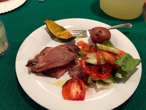
Thanks to our ship’s cooks, Harry and Darrin, we have an abundance of delicious and healthful food choices prepared daily onboard the R/V Norseman II. As each mealtime approaches I look forward to finding out what these two guys have whipped up to serve everyone onboard.


According to Head Cook Harry, who is a retired Navy cook with over 26 years of cooking experience, the biggest difference in meal preparation on a ship is the scale. They are preparing four full meals a day for 23 people in a small kitchen!

Their shifts are from 7 to 7. Harry works the day shift preparing lunch and supper. Darrin, the assistant cook, works the night shift preparing midnight meal and breakfast. You may recognize names of some of the famous chefs that Darrin has worked for during his off-season: Emeril and Chappy.

Darrin in the Galley crop
Assistant Cook Darrin works the night shift


The biggest challenge is planning the meals for 14 days without being able to go to the grocery store if something was forgotten. One thing Harry never, ever forgets is coffee. There must be plenty of coffee onboard.

Bunn Coffee Brewer

Improvisation becomes an important skill for the ship’s cook–to make do with what you have. Rotating foods and re-purposing leftovers into something tasty are essential. I must say these guys do a wonderful job of putting on a sumptuous, nutritious meal four times a day every day!

Sumptuous Meal

In addition to the great meals, Darrin is a pastry chef whose baking fills the ship with the delightful scents of cakes and cookies. Darrin shares that when baking on a ship you must rotate what’s in the oven often or it’ll come out lop-sided!

I’m also impressed that we are still having fresh green salads at this point in the voyage.

Harry relates that he buys lettuce in whole heads and keeps them cold. This enables him to get at least two weeks of good out of the fresh produce. A cool, dry place for storage of potatoes, carrots, beets and squash is in the fore peek hold located in the ship’s bow. Every nook and cranny of the ship is used for something! No wasted spaces here.

Good quality food and skilled meal preparation is very important on a lengthy voyage—for the health and overall morale of the hard working people on board the R/V Norseman II.

Hmmm….. I wonder what’s for lunch?

Whats For Lunch

Personal Log

I really can’t express the wonder and awe that I feel when getting to view the creatures from the deep. Seeing pictures is just not as good as seeing them in person and getting to hold them in my hands. They move and creep along exploring their new environs while Dann and Kasey and I take photos. With each new batch I get another wonderful science lesson from one of the scientists explaining the life cycles, behaviors and importance of these animals! Many of you will be happy to know that after their “glamour shots” most of the animals are returned to the ocean.

So, I just found out that I get to go out on the next dive boat! Yay!

This slideshow requires JavaScript.

Diane Stanitski: Days 20-25, September 4, 2002

NOAA Teacher at Sea

Diane Stanitski

Aboard NOAA Ship Ka’imimoana

August 16-30, 2002

Day 20: Friday, August 30

We arrived in Nuku Hiva with a bright sun beginning to set behind a band of gorgeous clouds. There was an air of excitement flowing through the group as land came into view. Because it’s customary to raise the flag of the country that you’re visiting, Steve, the ablebodied seaman and the XO, Doug, raised the French flag before arriving in port. We had a morning all hands (all on board) meeting to collect passports and explain procedures for docking. I spent most of the afternoon answering emails and working on lesson plans, two things I hadn’t had time to do this week because of the daily broadcasts that we completed. I also packed my books and clothes and began taking more pictures of all the spaces and people I hoped to remember on the ship. Aaaahhhh, I had such mixed feelings about leaving. We slowly made our way into the middle of Taihoae Bay, anchored, and raised a round black flag on the front mast designating that the ship is anchored. As we were waiting to hear from the gendarmerie, Nemo spotted three manta rays off the port side of the bow. They sailed through the water with kite-like bodies. Rain began to fall and we were finally told that we could take the RHIB to shore and that our passports would be stamped the next morning. A group of us decided to visit one of few local restaurants, a place that serves pizza, and we all enjoyed an evening together on land. Many people said that they still felt the rocking of the ship, even though we were on land, but I felt firmly planted. Don Shea and I felt so good that we decided to run back to the pier after dinner. Oh, what a feeling to run on solid ground!

Day 21: Saturday, August 31

I awoke early on the ship to depart on the 7:00 AM boat taxi to town. We wanted to make sure that we received the appropriate departure paperwork so we wouldn’t have a challenging time leaving French Polynesia in four days. With all paperwork complete a group of us walked along the one main road in the small fishing village to the bungalows at Pearl Lodge where John Kermond and I would stay. Wow, what a wonderful place! It overlooked the bay and had a beautiful (very small) pool with a pretty patio. I filled out the necessary paperwork for my room, but it wasn’t quite ready so I decided to return to the ship to gather my luggage. After a final goodbye to the KA (or so I thought), John and I returned to the Pearl Lodge, found our rooms, and were able to unpack and settle in for two nights. The Captain led a group hike over the mountain behind the lodge to beautiful Colette Bay where we swam in the waves and imagined that we were part of the Survivor series. We then scaled the volcanic cliffs to the end of the peninsula where a group of people were fishing for barracuda. Upon return to the hotel, I showered and decided to return to the KA one last time to check and reply to emails from my students. The ship was quiet because almost everyone was cherishing the last moments on shore before ship departure the next morning. I walked around the ship and a real feeling of sadness came over me. I was very surprised at my response to bidding farewell to this ship and the people I’d learned so much from during the last two weeks. I could really get used to life at sea. With a wave to the XO and Fred Bruns on the ship deck, I hopped back onto the boat taxi around 9:00 PM, was whisked away into the night air, and then returned to the bungalows for a much needed rest.

Day 22: Sunday, September 1

Nuku Hiva is predominantly Catholic and so the 8:00 AM Catholic service in town was the place to be on Sunday morning. The entire town was there. The church was absolutely beautiful and the music lifted the roof (as John said) off the building. The service was in both French and Tahitian, but very traditional and so easy to follow. Everyone, I mean EVERYONE sang the songs and that made it very powerful. After the Mass, we walked back to the bungalows to film the ship’s departure, however, it didn’t leave until nearly noon and so we waited for 2 hours on the hotel’s patio while the weather changed from hot and sunny to a torrential downpour with strong winds. After its departure we were then invited to take an afternoon jeep tour to the Typeevai, the valley where Herman Melville wrote his book Typee. We hiked to a ceremonial site with 11 Tikis carved in 1200 AD from the volcanic rock of the island – beautiful! It poured on us and our guide broke off a huge banana leaf that we used as an umbrella. I managed to receive about forty mosquito bites on my legs and arms and our guide picked a lime, cut it open, and applied it to the bites to relieve the itch – marvelous. What a gorgeous island.

Day 23: Monday, September 2

After a few hours making final arrangements for our flights and filming the last shots of Taihoae, we departed by four-wheel drive Land Rover later in the morning for a two-hour exciting trip to the airport northwest across the mountains and valleys of the remote, rugged island of Nuku Hiva. In the pouring rain the trip was treacherous. At times, the mud was up to the top of the tires and, although we had a difficult time seeing through the fog, we could tell there were steep cliffs on one side. Our driver had clearly made this trip before. We arrived safely and waited for our 3-hour flight to Papeete, Tahiti. We flew over atolls and through beautiful trade wind clouds.

Day 24: Tuesday, September 3

This was our only day in Tahiti. We awoke early and called Meteo France to see if we could have a tour of the weather station at the airport. We were trying to discover where the meteorological readings had been taken for the 100+ years of data recorded and now used to determine the Southern Oscillation Index. After a challenging conversation half in French, half in English, we were finally able to ask the necessary questions and receive a historical summary of the station. We were given a tour of the airport’s weather station and pamphlets to provide to my classes. John filmed the entire meeting. I was especially excited about this side trip because I’d always wanted to visit this specific weather station. Next on my list is Darwin, Australia, the sister site to the Tahiti station – maybe in a few years.

This experience has been like no other for me. I am so grateful to Dr. John Kermond, Jennifer Hammond, Rear Admiral Evelyn Fields, NOAA, NSF, Shippensburg University and all those responsible for my incredible journey. I will use the information that I learned on this trip in my classes, but more importantly, I hope to share the excitement and wonder of science with my students and my teaching colleagues so that they can understand the importance of conducting scientific research to discover more about our world and ourselves. Thank you to all!

Signing off for now, but I hope to hear from you again at dmstan@ship.edu.
Best wishes,
Diane

Diane Stanitski: Day 19, August 19, 2002

NOAA Teacher at Sea

Diane Stanitski

Aboard NOAA Ship Ka’imimoana

August 16-30, 2002

Day 19: Thursday, August 29, 2002

The FOO (Field Operations Officer)’s quote of the day: 

“The art of art, the glory of expression…is simplicity.”
– Walt Whitman

Weather Log:
Here are our observations at 1600 today:
Latitude: 4°59.00’S (into the Southern Hemisphere!)
Longitude: 139°49.2’W
Visibility: 12 nautical miles (nm)
Wind direction: 95°
Wind speed: 12 kts
Sea wave height: 3-4′
Swell wave height: 5-6′
Sea water temperature: 27.3°C
Sea level pressure: 1009.3 mb
Cloud cover: 2/8, Cumulus

Science and Technology Log:

I awoke early to be sure that I could hop on board the RHIB when it was ready to depart for our next buoy retrieval. John K. wanted to try something new…a live broadcast from the RHIB while he filmed from the ship. I suited up with a life jacket, hard hat, radio, microphone, and cameras. This would be a challenge. As it turned out, Larry, our electronics technician who assists with the technology end of the broadcast, and John could only hear me for a short distance away from the ship. John, however, caught the entire scene on camera. Upon arrival at the buoy I jumped on to it after Dave Zimmerman and asked him questions while he was dismantling the instruments so they didn’t break while the buoy was being retrieved. It was so much fun. There appeared to be quite a few barnacles and algae (very slimy) built up below the waterline on the buoy.

We then hopped off and drove back to the ship where we finished the broadcast. Ensign Sarah Dunsford then joined me and described the entire retrieval procedure from the boat deck of the ship looking back at the fantail. She did an excellent job.

We decided to hold off on the shooting of our general broadcast so that we could all pitch in to assist with the spooling of the cable as it was brought up from over 4000 meters of depth. This takes a few hours and I helped by turning one of the spools while the nylon cable wrapped around loop after loop. In between spools I helped Nadia with the barnacle removal. We scraped the entire buoy clean.

Someone then shouted that whales were spotted off the stern of the ship and I ran back to see if I could find them. There they were!!! I was told that there were ten of them, but I only saw about five. They were pilot whales, not too large – perhaps 12′ long – but still very beautiful as they swam through the water. What a treat!!! We completed the retrieval and went into the mess to eat lunch.

The afternoon consisted of conducting interviews during our final general broadcast from on board the ship. We are hoping to complete additional broadcasts from Nuku Hiva, if possible, and to shoot video footage in Tahiti at the Meteorological station. This was a fun broadcast. We interviewed Takeshi from France who played his flute and said a few words in French, Nemo who described his duties on the ship and showed up how to tie a few important knots, and Mike Strick who can often be found assisting in the kitchen as well as on the fantail – he does it all! The broadcast ended with the deployment of the buoy that would replace the one removed earlier today. A great day in my book!

Personal Log:

I began taking photos of all the people on the ship today. I don’t want to forget any of them as I leave this ship and sail back to my life in Shippensburg. It’s the little things that people do along the way that make all the difference, isn’t it!? During one of the CTD casts to 1000 meters, Jason Poe helped me miniaturize and mold a group of styrofoam cups that I could bring back to my family, friends, and students. Doug McKay (Nemo) assisted many times when I needed a hard hat or life jacket at the last moment in order to be able to experience something on the ship. Fred Bruns provided insight, feedback and tidbits of history about the ship. Larry Wooten was always ready to help with any technical problem that arose, no matter the time of day or night. Paul Freitag answered an unending array of questions that I had about the science on the ship. John Kermond, of course, was always there with new ideas and ways to make my experience the most exciting and informative possible. All of the officers on board cooperated during each of our broadcasts and permitted great flexibility so we could produce interesting and educational webcasts for all of you. I could go on and on…and probably will tomorrow during my final day on the ship while it’s at sea.

Takeshi taught one last French lesson tonight just after dinner while watching the sunset so that we would be prepared for arrival in Nuku Hiva. Most people are ready to see land before they complete their journey by ship, taking them back to Honolulu in the next few weeks. Six of us will depart in Nuku Hiva. I look forward to an opportunity to explore the island and to shoot more footage to be used in our videos on the web. After another productive day, it’s time for bed.

Question of the day: Name two of the instruments that are placed on the buoys at sea, and state what they measure. Email me one last time with your response. If you’re the first person to respond and I receive your answer early enough tomorrow, I might be able to include your name in my final logs.

Last full day at sea…
Diane

Diane Stanitski: Day 18, August 28, 2002

NOAA Teacher at Sea

Diane Stanitski

Aboard NOAA Ship Ka’imimoana

August 16-30, 2002

Day 18: Wednesday, August 28, 2002

The FOO (Field Operations Officer)’s quote of the day: 

“Better three hours too soon than a minute too late.”
– William Shakespeare

Weather Log:
Here are our observations at 0900 today:
Latitude: 3°39.88’S (into the Southern Hemisphere!)
Longitude: 140°00.36’W
Visibility: 12 nautical miles (nm)
Wind direction: 100°
Wind speed: 13 kts
Sea wave height: 4-5′
Swell wave height: 6-8′
Sea water temperature: 27.1°C
Sea level pressure: 1011.7 mb
Cloud cover: 2/8, Cumulus, Cirrus

Hurricane Genevieve lives!

Science and Technology Log:

I stayed up until I couldn’t keep my eyes open anymore last night. I finished the script and lesson plan for today’s broadcast with my graduate students in the Atmospheric Environment class. When I awoke at 0600, I realized that the fish bite test was already in progress on the fantail of the ship. I quickly prepared for my morning broadcast and then went outside to see if I could help place fish heads (mostly red snapper) on the lines that were being tested. The objective of the test was to qualitatively determine the fish-bite protection of a new armored mooring cable. The current cable that is used, nilspin, is very heavy while the cable to be tested is much lighter, but has a greater diameter. The test cable consists of a polyester core wrapped with electrical wires with up to two layers of special cloth armoring with a PE jacket. The cable diameter is ~221 mm. The test consisted of towing three 100 m cables (no armor, single, and double) simultaneously from the stern while the boat moved at 1-2 kts. Fish heads were attached every 3 meters to each cable. I was asked to take notes on the procedure since it was a new experiment and to use a multimeter to ensure that the lines were actually measuring electrical conductivity in case of a fish bite. Occasionally, I managed to assist with the deployment of the lines by helping place mesh bags alongside the line, opening the bag and inserting a partially frozen and slimy head of a fish, attaching the bag to the cable with wire ties, and then placing electrical tape over the wire tie and ends of the bags to keep them attached. It took approximately 2-1/2 hours to prepare the fish lines and deploy them. I really enjoyed it. There’s something exciting about having a group of people working together toward a common goal, especially when science is involved.

We started the broadcast soon after the fish bite test was running and I had the opportunity to interview a number of people on board who hadn’t been highlighted in a past broadcast. They were great! This was a more scientific webcast mostly focused on El Nino and the research conducted on the ship. I loved every minute and learned a great deal in the process. The video is 51 minutes long and can be accessed at on our videos page. Check it out when you have time.

I asked Lobo, our Chief Engineer, how portable water is created on the ship. He provided a great overview of the process. Seawater is converted into fresh water by vacuum distillation. In the end, the water is used for drinking, as process water, and for domestic purposes. The seawater to be distilled evaporates at a temperature of about 40°C (very low temperature for evaporation to occur) as it passes between the hot plates in an evaporator on board. The evaporating temperature corresponds to a vacuum of approximately 93%, which is maintained by the brine/air ejector. The vacuum serves to lower the evaporation temperature of the feed water. Having reach boiling temperature – which is lower than at atmospheric pressure – the feed water undergoes a partial evaporation, and the mixture of generated vapor and brine enters the separator vessel, where the brine is separated from the vapor and extracted by the combined brine/air ejector. The vapors that are generated pass through a demister where any drops of seawater that are entrained are removed and fall to the bottom of the distiller chamber. The vapors continue to the condenser where they condense to fresh water as they pass between cold plates. The freshwater that is produced is extracted by the freshwater pump and led to the freshwater tank. We can store approximately 3000 gallons of water on board.

I conducted a CTD test by myself for the first time tonight at 7:30 PM. Everything worked and we decided to test zucchini, a green pepper, a potato, and a round loaf of bread to see what happens to it when it’s submerged to the extreme pressure at 1000 meters below the water surface. When we finished the CTD cast where we sampled water at 1000m, 800 m, 600 m, 400 m, 200 m, 150, 100 m, 60 m, 40 m, 25 m, 10 m, and the surface, we brought the sampling cylinders up with the food. The potato looked and felt the same, the zucchini was squishy, the green pepper looked exactly the same but it had a crack on the side and was full of water. It must have burst on the way down and filled with water. In this case, the pressure would have been the same from the inside to the outside so no change in size took place. The bread looked like pita bread. It had been placed in plastic wrap, 2 zip-lock bags, and another plastic sleeve, but still managed to get wet. Interesting experiment.

Just after the CTD returned to the surface, I went to the starboard side of the ship to throw in an AOML, a device that measures water currents across the ocean surface (more on this tomorrow). AOMLs float away into the distance but transmit their data on a realtime basis. They are occasionally retrieved, but usually remain in the Pacific forever.

Personal Log:

I am receiving all of your emails – thank you! It’s great to hear that your first week of classes is going well. I will highlight several of your questions in tomorrow’s log!

Congratulations to Steve Osmanski who knew that the term “knot(s)” is a unit of maritime speed goes back to the days of sailing ships, when speed was measured by throwing a wooden device called a “chip log” over the stern of the ship. The chip log had a line attached with knots spaced along it. When the log was thrown overboard, a timing device (usually a 30-second sandglass) was turned and the number of knots that passed through the user’s hand as the line unreeled during the 30 seconds was the ship’s speed in nautical miles per hour. It was reported to the officer of the deck as so many “knots.” The distance between knots in a log line is calculated at 1.688 feet for every second in your timing interval; so a 30-second log line would have knots 50.64 feet (50 feet, 7 and 2/3rds inches, just about). Many of you answered this correctly, but Steve was first!

John and I played Yahtzee tonight in the third round of the match. I managed to win again so I move into the semi-final round.

Question of the day: How long is the Ka’imimoana? Check out Teacher at Sea web site for all the details.

Closer to land, but wishing I was further out to sea…
Diane

Diane Stanitski: Day 17, August 27, 2002

NOAA Teacher at Sea

Diane Stanitski

Aboard NOAA Ship Ka’imimoana

August 16-30, 2002

Day 17: Tuesday, August 27, 2002

We are still enjoying the equator today!!! (0° latitude, 140° west longitude)

The FOO (Field Operations Officer)’s quote of the day: 

“Just as much as we see in others we have in ourselves.”
– William Hazlitt

Weather Log:
Here are our observations at 1400 today:
Latitude: 0°00.49’S (into the Southern Hemisphere!)
Longitude: 139°52.4’W
Visibility: 12 nautical miles (nm)
Wind direction: 090°
Wind speed: 15 kts
Sea wave height: 3-4′
Swell wave height: 5-7′
Sea water temperature: 26.9°C
Sea level pressure: 1008.5 mb
Cloud cover: 4/8, Cumulus

A new tropical storm, Genevieve, is on her way to hurricane status! She is currently at 14°N, 115°W and is moving toward 280° at 6 kts. She has sustained winds at 60 kts with gusts to 75 kts.

Science and Technology Log:

After the equatorial buoy was retrieved late last night, most of the crew worked very late to pull in the 4500 meters of cable. Then, they needed to prepare the new buoy to be deployed this morning. Everyone is looking rather tired today. The CO and Chief Scientist joined us for a few moments at the start of our morning broadcast to participate in the buoy dedication ceremony. I first introduced the show and then we all signed our names on a large NOAA sticker, added a Shippensburg University Spirit sticker, and then attached them to the central cylinder on the buoy where all of the instrument electronics are stored. These stickers will be there for the next year until the buoy is retrieved again. Pretty neat, I think.

Our broadcasts took all morning to complete and overall went well. We continue to learn what works and what doesn’t with regard to the technology. It’s best to interview just a few people and when writing on the dry erase board, use black marker, not blue. As they say, practice makes perfect.

I realized tonight how much I love interviewing scientists, especially people who do things related to, but very different than, what I do. I am always fascinated with other scientists’ research because their methodologies are often so different from my own. They make me think, which definitely expands my mind.

Personal Log:

Well, I was up late last night preparing for double broadcasts today. I spend so much time in front of the computer in the main lounge that I arrived yesterday to find a sign saying, “Casa Diane”. I figured it was Lobo or Don who always comment that I spend too much time in “my office”. Kirby came by to say that the fish were jumping outside and invited me to join everyone on the deck. WOW! I have never seen so many fish in my life! There were hundreds of HUGE fish jumping out of the water, flying over the surface (flying fish), zipping up, down, over, and lurching at smaller fish that I could hardly believe my eyes. The sea was boiling! The fish were different from the starboard to the port side of the ship, tuna and sharks on port and rainbow runners on starboard. I caught my first real fish last night – a yellowfin tuna that probably weighed just under 10 lbs. Larry helped get me started and then coached me as I reeled it in…what fun!!! Everyone was cheering for all of us because all that you had to do was place your hook in the water and something latched on. Even if you had a bite, a shark often came by and snatched your prize. I’ll bet that I saw at least 50 sharks, hundreds of zipping tuna (which are gorgeous, by the way), a whole school of rainbow runners, and tons of flying fish. All in all, we caught at least 25 fish last night (a few around 40 lbs) and immediately cleaned and prepared them to be eaten every which way. A few people awoke early and caught another 20. I love sushimi the most, but we’ve also been eating fish fried, broiled, in salad form, etc. It reminds me of Forrest Gump – shrimp gumbo, shrimp salad, shrimp…! We did have to freeze some of the fish because there’s no way that we could eat everything in the next few days. The fish that were caught all had full stomachs comprised of many very small fish that looked like sardines. To top off the whole experience there was a bright moon above the horizon illuminating the bubbling water. Even the crew who have been on board for many years were impressed with last night’s scene. I am truly amazed by the sea! It brings something new every day. See my photo log for a few pictures of last night’s fiesta! Oh, and I forgot to say that two flying fish actually flew onto the ship overnight and were found this morning. I highlighted the larger one in my broadcasts today – simply amazing.

It has been another interesting day.

More tomorrow…
Diane

Diane Stanitski: Day 16, August 26, 2002

NOAA Teacher at Sea

Diane Stanitski

Aboard NOAA Ship Ka’imimoana

August 16-30, 2002

Day 16: Sunday, August 26, 2002

Today we are at the equator!!! (0° latitude, 140° west longitude)

The FOO (Field Operations Officer)’s quote of the day: 

“The greatest thing in the world is to know how to be self-sufficient.”
– Michael de Montaigne

Weather Log:
Here are our observations at 1400 today:
Latitude: 0°02’N
Longitude: 139°56’W
Visibility: 12 nautical miles (nm)
Wind direction: 140°
Wind speed: 9 kts
Sea wave height: 3-4′
Swell wave height: 5-7′
Sea water temperature: 27.1°C
Sea level pressure: 1010.3 mb
Cloud cover: 4/8, Cumulus, Altocumulus

Hurricane Fausto is currently located at 21.3°N, 132.7°W and continues to diminish in strength. It has sustained winds of 60 kt, gusting to 75 kt. and is moving toward 300° (WNW) at 15 kt. Its central pressure has risen to 987 mb.

Greeting:

First of all, I’d like to say WELCOME to my classes at Shippensburg University. Today is the first day of classes there and I want to acknowledge those people who are helping to cover my classes and are also assisting with the link between me and my students this week and next. Those who have helped tremendously include Drs. Niel Brasher, George Pomeroy, William Rense, Christopher Woltemade, and Holly Smith. Thank you!

I have already received email messages from many of you in my classes. Remember, part of your assignment for this first week is to email me at least 3 times asking me questions about the ship’s operations, science on board, or anything else that you feel would be of interest to you. Please read all of my logs, check out my photos, watch the previous videos, and follow the path that the ship takes across the Pacific Ocean. We’ll be referring to all of the information shared on the web throughout the semester. Welcome to the Pacific Ocean – glad you could join me!

Science and Technology Log:

I awoke and immediately starting preparing for our second general broadcast of the trip. Seven guests were scheduled to be interviewed during this broadcast. They did an excellent job. Unfortunately, Dave Zimmerman was immersed in the operations of the morning Acoustic Doppler Current Profiler (ADCP) retrieval and deployment, and so couldn’t join us for a short interview. I’ll try to catch him again when things aren’t quite as hectic. Overall, the show went well and I’ll spend the rest of the day preparing for the next three broadcasts with my students in Introduction to the Atmosphere, Meteorology, and the Atmospheric Environment at Shippensburg University. I’m anxious to meet everyone in the classroom from the ship to share some of the things that I’ve been learning on board the Ka’imimoana. Please check out all of the videos on this web site to see who I’ve interviewed in the past. The ship’s scientific equipment and research, and my interactions with scientists using them, will definitely add to what I teach in the classroom, which should make for a more interesting and valuable experience for all of you.

Here are some interesting facts about the ADCP. It is a subsurface mooring, which means that it is anchored to the bottom of the ocean but remains nearly 300 meters below the surface of the water, and it measures current velocity profiles. It is a large round floating orange sphere (see photo logs) that measures the velocity of ocean currents in approximately the upper 250 meters of the ocean using the Doppler effect. Today, after triggering the acoustic release separating the anchor from the old ADCP that was being replaced, the instrument emerged at the surface of the water, was spotted, and then dragged through the water to the ship where it was hoisted up with one of the ship’s cranes onto the fantail. The thousands of meters of line were then reeled in and later deployed again with a replacement ADCP attached. The instrument uses the Doppler effect meaning that there is a change in the observed sound pitch that results from relative motion of an object, in this case water. If something is coming toward you, the wave frequency appears to be higher and if something is going away from you, the frequency of waves appears to be lower. The example that is always used is that of a moving train. The train’s whistle has a higher pitch when the train approaches and a lower pitch when it moves away from you. The change in pitch is directly proportional to how fast the train is moving. If you measure the pitch and how much it changes, you can calculate the speed of the train.

ADCPs use the Doppler effect by transmitting sound at a fixed frequency and listening to echoes returning from waves and sound scatterers in the water, such as small particles or plankton reflecting the sound back to the ADCP. Scatterers float in the water and on average they move at the same horizontal velocity as the water. When these scatterers move toward the ADCP, the sound heard by the organisms is Doppler-shifted to a higher frequency. The ADCP uses four beams to obtain velocity in many dimensions. Overall, it’s an amazing instrument.

The equatorial buoy was retrieved tonight and a new one will be deployed tomorrow. That buoy will be dedicated to the Grace B. Luhrs Elementary School and Shippensburg University. It will be signed by the Captain, Chief Scientist, and me, and will be located at 0°, 140°W for the next year. Shippensburg’s name will be on the Pacific for at least 365 days!

Personal Log:

Most of my afternoon and evening was spent answering emails and preparing lesson plans. I am looking forward to tomorrow’s activities but have many miles to go before I sleep. Keep in touch!

Question of the day: 

At what heights in the atmosphere are altostratus or altocumulus clouds found?

One of my Meteorology students, Steve Osmanski, provided the correct answer to my previous question of the day, “what are crepuscular rays?” His answer is: “They are the classic ‘sunburst’ effect caused when sunlight is blocked by a cloud and appears to be “streaming in rays” around the shadow. They are visible from scattering of sunlight by dust or water droplets, and appear to diverge as a trick of perspective.” Excellent, Steve! I look forward to having you in class!

Until tomorrow…
Diane

Diane Stanitski: Day 15, August 25, 2002

NOAA Teacher at Sea

Diane Stanitski

Aboard NOAA Ship Ka’imimoana

August 16-30, 2002

Day 15: Sunday, August 25, 2002

The FOO’s quote of the day (I really like this one!):

“Let your dreams run wild and free and always follow where they lead.” – N.E. Foster

Weather Log:
Here are our observations at 2200 today:
Latitude: 1°31.9’N
Longitude: 140°00.5’W
Visibility: 12 nautical miles (nm)
Wind direction: 120°
Wind speed: 12 kts
Sea wave height: 3-4′
Swell wave height: 4-5′
Sea water temperature: 27.3°C
Sea level pressure: 1011.7 mb
Cloud cover: 3/8, Cumulus

Hurricane Fausto is slightly diminishing in strength, but is still maintaining winds at 90 kts, gusting to 110 kts. It is currently located at 18°N, 125°W and is moving northwest. Another tropical depression has formed at 11.5°N, 148°W and has maximum sustained winds at 30 kts with gusts to 40 kts. It is expected to gain strength and move into the tropical storm category. We are definitely not in danger of being impacted by either storm because they require Coriolis to form or to be sustained. Coriolis is negligible at the equator so we’re safe!

Science and Technology Log:

This has been my favorite day of the trip so far! I awoke hurriedly at 5:50 AM and ran outside with my hard hat and life jacket. We were taking the RHIB (once again, the rigid inflatable boat) out to retrieve our first buoy. Earl, Dave, Paul, Doug and I rode toward a gorgeous sunrise, removed sensors from the buoy, and then hooked it to a line to drag it in toward the ship. What an amazing morning! It all started there. As soon as the buoy was lifted onto the dock Nadia and I began removing barnacles from the bottom of the frame. The barnacles were still alive with their legs appearing and disappearing within their hard shell. They stick to the mast, buoy, and inner flotation device in clumps. At this point, I am filthy, smelly and loving every second. The barnacles are full of sea water which occasionally bursts and runs down your arms as you work over your head. I’m sure I’ll smell like fish for the rest of the day. The retrieved buoy was then power washed to remove the salt water, algae, and remaining barnacles parts, and to prepare it to be deployed again later during the trip.

I then helped pull in the 4300 meters of nilspin and nylon cable by taking over one of the spools where I turned it around and around as the cable draped over the top. Fun, and tiring! Just as we finished with the last spool, Doug, the XO, decided to fish off the back of the ship. You should have seen the amazing fish swimming all around the fantail of the boat… mahi mahi, and every beautifully colored huge fish that you can imagine! A blow hole was spotted by the FOO earlier, sure signs of a whale nearby. I also saw a huge fish jump out of the water, but couldn’t identify it. The fish all hang out around the buoy because of the barnacles (food) and the shadow created by the buoy, thus creating a small ecosystem in the middle of the Pacific. Suddenly, Doug caught something! He had to keep reeling in the line until he pulled a wahoo on board (ono in Hawaiian, meaning sweet). It had unbelievable colors of green and blue and was shiny with stripes. It had a cigar-shaped body, pointed head, and triangular teeth, with a long dorsal fin separated into 9 segments. Nemo brought it into the shade, pierced its neck, and then returned to the fantail where he caught two beautiful yellowfin tuna – WOW! They were shaped like a football, were beautifully iridescent with yellow, gold and blue across their bodies and fins tinged with yellow. The fins were very long. We feasted on sushimi tonight at dinner, raw tuna fillets with wasabi and soy sauce – scrumptious! We also had baked ono (wahoo) with spices. YUM! Thanks, Doug and Nemo!

We then all worked to prepare the nilspin (cable closest to the buoy) for the next buoy deployment by placing fairings on the cable. Fairings are plastic sleeves that are rectangular and slide onto the cable to provide more friction with the water. This alleviates great movement of the cable that usually happens due to strong ocean currents at this latitude. We are so close to the equator that the equatorial countercurrent makes a huge difference in the movement of the subsurface line. It was like an assembly line with me lifting each fairing out of a garbage can, handing each one to Dave who opened it and slide it onto the cable. Then, Paul used a mallet to secure it on the line while Jon held the cable in place so it didn’t drift off the boat. We must have placed hundreds of them on the line while it was being pulled out to sea by the new buoy that we just deployed (see photo log for pictures of the buoy retrieval and deployment). In the end, it took about 3 hours for the nearly 5000 meters of nilspin cable and nylon cable to be unrolled and pulled by the buoy out to sea. The buoy was floating about 4 km away from the ship by the time the cable was unraveled. You could just see it on the horizon. The crew then dropped two massive anchors (old railcar wheels) into the sea, which sunk and pulled the cable down while pulling the buoy into place above. The entire procedure is a real sight to see because of the crew’s efficiency…truly impressive.

Before dinner, John and I sat down and completed the script for tomorrow’s broadcast, however, things might change because we will be starting the science on board at the same time our broadcast is supposed to air live (9:00 AM ship time). We may have to change the show’s schedule if something exciting is happening on the ship that might be of interest to all of you. Flexibility is key to it all, I’m told.

Personal Log:

After a workout, shower, and dinner, John shot some footage of me on the bridge deck summarizing my experiences thus far, and describing what’s yet to come during this next week. The sunset was outstanding again. There were many clouds and they created these streaming rays of bright yellow light from the setting sun down to the Pacific. I could easily watch this every night.

I’m going to finish my logs and head straight to bed. This was truly the most outstanding 24 hours of the entire trip. I am so lucky to be here and can’t believe that we’re heading to the equator tomorrow!

Question of the day: 

What does TAO stand for and what is the goal of the project?

My favorite day of the trip so far…
Diane

Diane Stanitski: Day 14, August 24, 2002

NOAA Teacher at Sea

Diane Stanitski

Aboard NOAA Ship Ka’imimoana

August 16-30, 2002

Day 14: Saturday, August 24, 2002

The FOO’s quote of the day: 

“I believe because it is impossible.” – Tertullian

Weather log:
Here are our observations at 0900 today:
Latitude: 4°40.8’N
Longitude: 139°58.7’W
Visibility: 12 nautical miles (nm)
Wind direction: 180° (constantly shifting)
Wind speed: 16 kts
Sea wave height: 3-4′
Swell wave height: 5-7′
Sea water temperature: 27.7°C
Sea level pressure: 1011.3 mb
Cloud cover: 7/8, Cumulus, Stratocumulus

Science Log:

Another buoy was repaired this morning because its anemometer wasn’t functioning. The anemometer is the highest object on the buoy and, therefore, is the most vulnerable. Because it’s not as protected and is a moving part, it can be easily damaged by people fishing the area, or by extreme weather. Dave was out on the buoy sitting in the horseshoe (a square opening on the starboard side of the buoy deck permitting you to work on the bottom of the buoy from the deck below) today testing and preparing it for deployment tomorrow. This will be our first buoy replacement, which means that when we retrieve the next buoy there will be oodles of work to do on the ship, including counting the thousands of barnacles that have attached themselves to the bottom of the brace. I can’t wait to smell the deck after they’re removed from the bottom – mm, mm!

On the agenda today is a full tour of the ship. John taped me both inside and outside explaining every part of the ship as we walked from deck to deck and bow to stern. I learned so much through that process. John first explained what we were looking at and then I provided my version as I tried to incorporate the technical terms. We also prepared some fun clips interviewing people about what they do on board.

Despite volunteering to do a CTD launch at 3°N tonight at 1930, the device wasn’t working. The 0130 reading at 2.5°N tomorrow morning was also cancelled because Larry and Jason need to switch out a major part that is malfunctioning. It will soon be time to rise and shine for a buoy retrieval (my first!) and deployment.

Personal Log:

I awoke this morning to sunshine streaming through our porthole. This is an unusual occurrence since it has been so cloudy. I walked outside and smelled FISH! The guys had pulled in the tow lines and they caught 4 gorgeous silvery mahi mahi fish, one over 20 lbs. When I went downstairs, they were filleting them in the kitchen for lunch and hopefully dinner! Wow! This is what I call fresh. They found tuna in one of the stomachs of the largest mahi mahi. I’ll have to make sure that I’m around when they pull in the next group.

Lobo, the Chief Engineer on board the ship, provided John, Takeshi (scientist from France), and me with a tour of the engine room this afternoon. The most fascinating thing to me is how fresh water is produced on the ship. We use approximately 3,000 gallons of fresh water per day, which means that we are each allotted about 100 gallons. This is plenty per person. The majority of the water is used for the CTD cast because fresh water has to be used to spray down the winch, wire, and cylinders after they are brought out of the water (see photo log for picture), and also for cooking and laundry. It is an extremely comfortable ship. The CO was saying today at lunch that the main halls are much wider than many ships and the staterooms are also more roomy. I was surprised at how decadent my room seems to be. Check out the photo log for a picture of my stateroom.

It is hard to believe how close we are to the equator. We continue moving southward along 140°W. I’m getting a little bit nervous about the fact that there are at least 6 people who have never crossed the equator before in a boat/ship. This means that we are called pollywogs. If time permits, there might be a ceremony at the crossing for all first timers, after which you become shellbacks. It’s not quite that easy, though. There is a certain amount of harassment (all in fun, of course) that must first take place to ensure that the wogs EARN the right to cross. Rumors are spreading that something might happen soon. I’ll keep you updated.

You would not have believed the bioluminescence in the water tonight! Kirby and Don spotted it first and suggested that I go up to the bow to peer over the edge at the bottom of the bow as it plows through the water. The phytoplankton become disturbed, which causes them to glow. There are often patches or clumps of these species that are visible making them look like a glow stick in the water. We may have also seen some jellyfish glowing, but only because they’ve eaten the bioluminescent phytoplankton. It’s so interesting. I love hanging my arms over the railing of the bow watching it carve out the water far below.

The sunset and moon rise were incredible tonight. The sun’s rays continued to light up the sky for about an hour after the sun actually set. The colors of light blue growing into bright pink were beautiful. We also had low cumulus clouds far beneath high cirrus clouds that turned pink. It was a spectacular scene (see photo log). I wish that I could have captured the moon rise over the ocean. It looked HUGE and was bright orange. There were thin clouds in the foreground that created an eerie, yet beautiful glow. The moon is almost full and illuminates the ocean surface like a huge flashlight. The Milky Way is in full view and the constellations are brilliant. We were looking for the Southern Cross tonight and think that we may have spotted it. Aaaahhhh!

I’ll write more tomorrow.
Diane

Diane Stanitski: Day 13, August 23, 2002

NOAA Teacher at Sea

Diane Stanitski

Aboard NOAA Ship Ka’imimoana

August 16-30, 2002

Day 13: August 23, 2002

The FOO’s quote of the day: “Happiness depends upon ourselves.”
– Aristotle

Weather log:
We started this morning with some cloud cover but with bright sunlight illuminating the buoy deck where our live broadcast was about to be filmed. Moments after we finished, the skies opened up – downpour! Here are our observations at 2200 this evening:
Latitude: 5°48.6’N
Longitude: 140°1.7’W
Visibility: 8 nautical miles (nm)
Wind direction: 350° (constantly shifting)
Wind speed: 10 kts
Sea wave height: 2-3′
Swell wave height: 4-5′
Sea water temperature: 28.4°C
Sea level pressure: 1011.9 mb
Cloud cover: 8/8, rain with cumulus clouds

Here’s the update on what is now Hurricane Fausto, currently located at 15.3°N, 120.0°W and heading 280° (just north of west) at 14 kts. Its central pressure has dropped to 959 mb and its maximum sustained winds are 105 kts, gusting to 130 kts. It’s still running strong.

Science and Technology Log:

I believe that our live broadcast went quite well today, but only after being disconnected twice after only seconds of the first two takes. No harm done in the end. The interviewees were great! They are all such interesting and unique people with fascinating lives. After reviewing the show later, we discovered that a loud buzz muffled some of the interviews. The problem was detected and will be fixed before Monday’s broadcast.

Congratulations to Holly Smith, one of my graduate students at Shippensburg University, who answered our KA quiz question, “What is a Kelvin wave?” correctly. Her answer is “A Kelvin wave is a warm pacific wave that forms near Indonesia and travels east toward the Americas. It can carry warm air and a bit of rain with it too!” Yes, although Kelvin waves can form anytime, this wave is often highlighted during El Niño events because the weakening or reversing of wind direction in the tropics permits the warm water in the western Pacific to move eastward shifting the high sea-surface temperatures from the western to the central Pacific, which affects the atmospheric circulation. It also tends to shut off the upwelling in the eastern Pacific, which reduces the number of marine organisms in that region. Holly, you’ll receive a NOAA T-shirt for your efforts and knowledge – great job!

I volunteered to do the CTD test by myself this afternoon with a little (ok, a lot of) help from Jason, the survey technician. I think I’ve got it down at this point and will gladly assist with these readings that need to be taken approximately every six hours. It’s a time intensive job and tonight’s 3 AM readings will take around 3 hours and sample water from the bottom of the ocean, near 4000 meters depth.

After the CTD sampling, I interviewed Larry Wooten, our technician on the ship, in order to discover how he arrived at the Ka’imimoana. Larry had been in the Air Force in South Dakota as a missile technician. He then went to South Dakota State University to become an electronic engineering technician. He said that he typically spends 6 months on the ship and 6 months off during the year so he can return to Seattle to spend time with his wife and daughter. He is able to do almost anything on the ship, however, the majority of his time is now spent as network administrator (helping with software applications and fixing computers) and less on hands on electronics. Overall, a great guy ready to help in a flash.

Personal Log:

Shortly after Larry’s interview, we had a fire drill followed by an abandon ship drill. The fire was supposedly in the computer lab, the location where we’re all supposed to go in case of a fire. So, I found myself on the upper deck with two other scientists. It was only after much searching that we discovered all of the other scientists in the forward lounge. Whoops! Now I know where to go in both situations. The abandon ship drill went well. We all had to don our gumby suits this time to ensure that we know how to quickly suit up in case we need to go directly into the water. We also have to bring long pants and a long-sleeved shirt in case we end up spending a long time in the rescue boats in the sun. Fortunately, everything is extremely safe on the ship, but the drills help us to know what to do in all situations.

I received an excellent question from Austin at the National Weather Service in Phoenix, Arizona. He is wondering how the MGO, Kelvin wave, and thermocline are all linked. Now that we know about Kelvin waves based on Holly’s correct answer, you can see the relationship with the thermocline. But, what about the Madden-Julian Oscillation? This is a phenomenon named after the two scientists who initially discovered the oscillation. This oscillation triggers an extremely wide band of convective activity that sweeps from west to east across the equator every 30-60 days. It has been hypothesized that the MJO could possibly be a trigger for El Nino.

In just a few moments I play the Captain in Scrabble. It’s my favorite game that I often play with my Mom and best friend, Lisa. I’ll get back to you regarding the outcome.

The question of the day for all of you is: 

What causes a halo to form around the moon (or the sun)?

Keep in touch,
Diane


Diane Stanitski: Day 12, August 22, 2002

NOAA Teacher at Sea

Diane Stanitski

Aboard NOAA Ship Ka’imimoana

August 16-30, 2002

Day 12: August 22, 2002

Weather log:
We currently have nearly overcast skies again with rain falling from cumulus and stratocumulus clouds. Our observations at 0800 this morning are:
Latitude: 10°38’N
Longitude: 141°26’W
Visibility: 12 nautical miles (nm)
Wind direction: 200° (direction from which the wind is blowing)
Wind speed: 13 kts
Sea wave height: 4-6′
Swell wave height: 6-8′
Sea water temperature: 27.6°C
Sea level pressure: 1010.0 mb
Cloud cover: 7/8, rain from cumulus and stratocumulus clouds

I awoke last night to swells approaching 8′ and the ship rockin’ and a rollin’! We were in the tail end of a low pressure system with lots of convection (new word from yesterday’s log) causing turbulence in the air and seas. A bottle had fallen over in the bathroom and it continued to roll back and forth hitting the walls for about 10 minutes before I was awake enough to realize the source of the sound; I then climbed down the ladder from the top bunk to rescue the bottle.

Right now, we are attempting to avoid Tropical Storm Fausto, which is currently located to our east and heading 275° (just north of west) at 11 kts. Its central pressure is 994 mb and its maximum sustained winds are 55-65 kts with 12′ seas. The Hurricane Prediction Center’s 72-hour forecast shows 75 kt winds with the possibility of gusts to 90 kts on the 25th with continued movement NW. We should slide just south of the storm and might feel some effects, but they’ll likely be minimal. Aaah, wonderful tropical weather in August! Check out www.weather.gov and view their tropical weather or hurricane page to determine the actual path of the tropical storm.

Science and technology log:
We conducted another live test broadcast this morning with the main Office of Global Programs office and Caption Colorado, the company that will provide captioning for the broadcast. It was 18 minutes long and the transfer was a success. The decision has been made that we’ll do a 20 minute live broadcast tomorrow (Friday) to be received at 4:00 PM EST in the U.S. If you miss Friday’s live broadcast, be sure to contact Jennifer at jennifer.hammond@noaa.gov before next Monday to tune into our upcoming broadcasts next week. I’m also anxious to hear from more of you about your interests in oceanography and climatology and the questions that you have for me that I’ll share with our global audience next week. I will do my best to find the answers!

The first official CTD data collection took place last night at 7:30 PM (1930) and a 3:30 AM reading this morning also proved to be successful. I awoke at 2 AM to see if Jason and Paul needed help, but it wasn’t yet time to conduct the test so I happily went back to bed. I did assist with today’s CTD at 12:20 this afternoon. I was so amazed at the entire process. First, the ship must stop and hover for approximately 1 to 1-1/2 hours over the same spot while the CTD sampling takes place. There are 12 depths at which water samples are collected in large cylinders between the ocean’s surface and 1000 m down (See yesterday’s photos for a picture of the CTD cylinders.). Just think of the pressure being exerted on the cylinders at over 3000 ft below the surface! Kirby, one of our two NASA scientists, gave me a styrofoam cup that was intentionally sent down with the cylinders and it’s now a small crushed, but perfect cup. I can’t wait to show my students! The person who controls the CTD from the computer end must work in close cooperation with the winch operator who is in charge of carefully lowering the heavy CTD device into the water and releasing it at different rates of speed to various depths. Any air bubbles that are present must be pushed out of the cylinders so the CTD is first lowered to 10 m, raised to just below the surface, and then lowered again to the greater depths. If the ship’s schedule is not rushed (unlike today), the CTD is lowered to approximately 200 meters off the ocean floor, which could be down to almost 5000 meters, our current depth below this ship! We only had time to lower the sensors to 1000 m today, and then the winch operator raised the CTD to 12 different depths where the carousels (cylinders) were “fired” to allow the bottles to flush and for samples to be collected. Lastly, two samples were taken at the surface. Once the CTD was lifted out of the water, Nadia, my roommate, collected water samples (see photo log) from each of the 13 cylinders to study salinity levels, which tells us something about the conductivity of the water. One reason that this is useful is because the degree of salinity in the water is related to flow of warm and cold ocean currents to and from higher latitudes, and may have been responsible for sudden shifts in climate in the past based on the slowing of our global currents! I have found that it’s incredibly important to ask why each study on the ship is significant to place it in context and to understand the big picture.

John and I met in the early afternoon to create the storyboard for tomorrow’s broadcast. We will highlight the Captain or Skipper of the ship; our Chief Scientist; Medical Officer; Lobo, the Chief Engineer; and Doretha, the Cook. We’ll also have an opportunity for you to win a NOAA T-shirt if you respond with the correct answer to our KA quiz question.

The Chief Scientist and I played 2 out of 3 Yahtzee games tonight just after dinner. It looks like I’m heading to the next round, lucky me! That’s about all that Yahtzee is, luck, but an awful lot of fun. I was invited to ride the RHIB tonight to make our way to a buoy that needed repair. The evening ride was beautiful! There was a full moon with a gorgeous halo around it (good question for tomorrow’s log) and approximately 4′ swells that made it just a bit rocky. There were six of us in the boat. Two scientists hopped onto the floating buoys and started making repairs because there was major damage to the anemometer and the precipitation gauge. One of them started feeling seasick because you’re swaying (just a bit) back and forth and you’re about 8′ above the ocean surface. He hopped off and they asked if I’d like to jump on to help with the buoy repair! Wow! (Mom, please skip this part…I couldn’t help myself.) It was safe, yet thrilling. I helped get the new rain gauge in order and placed small spikes on the top to keep birds from sitting on the edge of the sensor making their own contributions to the contents of the inner gauge. I also helped test it by pouring water through as Dave downloaded data from all the sensors to a computer and checked to make sure they were up and running. I couldn’t believe how lucky I was! I was floating on a buoy in the middle of the Pacific Ocean helping to fix meteorological instrumentation! The ship was all lit up in the distance about ½ a mile from the buoy. We found the exact location of the buoy because of the ship’s radar that spotted it right away and led us to the floating donut. I’ll include some (very dark) photos of this adventure tomorrow.

Well, I’m going to review my notes for tomorrow’s broadcast before heading to bed. It has been another grand day on the great Pacific.

The question of the day for all of you is: What are crepuscular rays? Yes, please consult your meteorology text sitting on your shelf, the Web, or my photo log, to find out. Then, email me to let me know how smart you are!

The FOO’s quote of the day: “Adversity is the first path to truth.”
– Lord Byron

Hope to hear from you soon,
Diane

Diane Stanitski: Day 11, August 21, 2002

NOAA Teacher at Sea

Diane Stanitski

Aboard NOAA Ship Ka’imimoana

August 16-30, 2002

Day 11: August 21, 2002

Weather log:
I awoke and went out on the buoy deck this morning to find rain falling from overcast skies! Here are our observations at 0800 this morning:
Latitude: 13°28’N
Longitude: 143°28’W
Visibility: 12 nautical miles (nm)
Wind direction: 100° (direction from which the wind is blowing)
Wind speed: 15 kts
Sea wave height: 4-5′
Swell wave height: 5-7′
Sea water temperature: 27.4°C
Sea level pressure: 1012.2 mb
Dry bulb temperature: 25.0°C
Wet bulb temperature: 24.0°C
Cloud cover: 8/8, rain from altostratus clouds

If you’ve been mapping out our course on a “chart” of the Pacific Ocean (as I’m sure you all are!), you may have noticed that we’ve made a sudden shift to the south! Why? To divert away from a tropical depression forming to our east! The Commanding Officer, CDR Mark Ablondi, made the decision late last night, after French class, to reverse the order of our trip. Instead of visiting the buoys from north to south along 125°W and then cruising west toward the 140°W line, we’ll first head south along the 140°W meridian and then toward 125°W. Flexibility is key to the success of the trip, especially when considering the safety of the crew. A tropical wave is heading our way with a tropical depression behind it. To our north there are a series of subtropical high pressure cells which will cause the tropical depression to slide due west, very close to our original path, thus the reason for the change. We’re hoping to avoid all signs of the storm. However, we currently have overcast skies and rain falling from beautiful altostratus clouds. The only thing constant about the weather is change – gotta love it!

Science log:
Our most exciting part of the morning so far has been a live test broadcast with Jennifer Hammond at NOAA’s Silver Spring office and others who will enable a future broadcast to come live to you. We had to attempt it three times because we kept getting disconnected. Larry, our very important computer technician on board, is looking into the cause of the problem. We’ll try another live broadcast test tomorrow morning before our first general broadcast, hopefully later this week (stay tuned on the web site for further information).

The constructed buoy that was going to replace the one to be removed at 8°N, 125°W, will now be used for the 2°N, 140°W replacement. Because ocean currents are much stronger near the equator, the buoys require more flotation. This means that two extra fiberglass inserts are placed inside the buoy (sort of like adding the donut hole to the donut). This will enable the buoy to float more effectively.

We tested the CTD profiler early this afternoon. CTD stands for conductivity, temperature, and depth. This instrument continuously records data as it is lowered through the water column to nearly the bottom of the ocean. It also collects water samples at preselected depths. Water is then brought to the surface from these depths and analyzed for salt and nutrient content. I have been asked to take some of the CTD measurements since we’ll be doing them a few times every day and I’m told it takes 1-2 hours. I’m very interested to see what it entails. I think that Jason will train four of us tomorrow.

Well, I reread my logs and decided that I need to provide some context as to why we’re all on the Ka’imimoana in the first place. El Niño! You’ve all heard the term, I’m sure, but what does it mean, and should it concern us?

Here is the story…
El Niño, Spanish for “the boy” or “the Christ Child”, is a phenomenon that refers to a warm ocean current that typically occurs around December (Christmas-time) off the west coast of Peru and lasts for many months. This appears to be related to a warming of the entire tropical Pacific Ocean.

Let’s go back even further… Under normal ocean and atmosphere conditions (during non-El Niño years), the trade winds in the Pacific blow from east to west across the tropical Pacific Ocean, dragging the ocean water beneath with them (due to friction). Because the water is being moved toward the western Pacific, it piles up such that the actual surface of the water near Indonesia can be up to approximately ½ meter (~1.5′) higher than off the west coast of South America – amazing! The sea surface temperature near Indonesia is also about 8°C (how many °F?) warmer than near South America because it has been warmed by the sun as it crossed the Pacific near the equator. Near South America, cold subsurface water then emerges at the ocean surface to take the place of the water that moved westward. This process is known as “upwelling” and brings cold, nutrient-rich water to the surface, which is attractive to many fish species, including the anchovy.

Warm ocean water is important for many reasons, primarily because it has a direct relationship with the atmosphere above it. Above warm water, evaporation increases, winds at the surface flow together, and clouds form. Thunderstorms form much more easily under these conditions causing rain. Heat is transferred from the ocean to the atmosphere in this process, known as “convection”. This shows why there is such a direct and important link between the ocean’s temperature and the winds in the atmosphere. Convection usually occurs over the warmest water and winds blow toward the warm rising air from all directions. Energy is transferred and this is one of the important flows across earth. I always tell my students that the earth constantly tries to maintain a balance and this is why there is movement. Earth is dissatisfied with excess heat near the equator and cold air hovering around the poles. In a move toward equilibrium, the wind flows and the ocean currents move…energy is being transferred! Okay, I could go on for days about this because I love it so much. Let’s move on to El Niño. During El Niño events, which typically occurred every 3-7 years in the past, but may be happening more often now, large-scale winds that normally blow from east to west across the Pacific Ocean diminish, and occasionally even reverse direction. Now, the warm water that is typically found in the western Pacific moves toward the eastern Pacific and, voila!, little upwelling occurs along the coast of South America resulting in fewer nutrients for the phytoplankton and other marine life that survive on the nutrients brought from below. With warmer water in the eastern Pacific, the process of convection shifts eastward with the warm water so the rising air and ensuing storms are found closer to the central Pacific.

Why is this important? El Niño results in changes to temperature and rainfall on a GLOBAL basis. For instance, because convection shifts eastward, parts of northeastern Australia often experience a major drought while the coast of Chile can receive severe floods. The 1997 El Niño event, one of the strongest ever experienced and recorded, resulted in heavy rains over the southern U.S., record rains in California, and a mild winter in the mid-western states of the U.S. At times, the monsoon that affects Southeast Asia arrives much later than normal. We are on the Ka’imimoana to help predict upcoming El Niño events . This is done with the help of 70 buoys that are located on the tropical ocean surface between 8°N and 8°S latitude. Sensors on these buoys measure atmospheric conditions like wind speed, wind direction, air temperature, relative humidity, radiation, and ocean temperature data from the surface to 500 meters below, to help determine if an El Niño event is occurring, or not. We do know that an El Niño is currently forming in the Pacific. Now, we need to ensure that all possible data are available by checking to make sure the sensors are functioning properly and that data are being sent via satellite to researchers who are using models to predict the severity of this event.

With early prediction of an El Niño, countries can adjust the types of crops that they grow, and plan in areas such as water resources, fisheries, and reserves of grain and fuel. Countries that have experienced the effects of El Niño in the past can also effectively plan in advance for drought, floods, and extreme weather, a consequence of the phenomenon, El Niño.

If you are a teacher, I’m writing a lesson plan related to the current El Niño conditions in the Pacific that you can use in your classroom. I will provide optional assignments so that you can use it from the middle school to college level. Please check my lesson plans in the next week to find this activity. Paul Freitag, Chief Scientist on board, is assisting with the exercise by providing current ocean temperature data and informed ideas.

Personal log:
I have remarked a few times today how helpful everyone is on the ship regarding questions that the new people have (that includes me!) or things that we need. This is a tremendous group of people. The Doc helped lower my bunk bed on the first day, after I spent 15 minutes trying every possible hole, button, lever, etc., until she discovered it was actually screwed into the wall. Doug McKay is helping me practice my knot tying which I started learning with my husband in Honolulu; I hope to be of some use on the RHIB or on the decks in the future when things need to be tied down.

John Kermond has answered every imaginable question, many times more than once. He has been very patient. The Chief Scientist endures my many inquiries about the TAO buoys and manages to come up with appropriate manuscripts and manuals whenever I need extra information. The Captain took the time to provide an overview of Pacific Ocean weather this morning before our test broadcast. It’s amazing how many questions I have each day. I even had to learn how to open the doors to go out on the deck. There is a lever that you lift to a certain point which allows you to exit; you then need to lower the lever again once you leave. This keeps the doors from flying open on their own and also keeps them water tight. I ended up sleeping with my stateroom door open the entire first night on the ship because I didn’t realize that it clicks shut only after much force. I woke up and the door was wide open. Taking a shower is always interesting. I’ve learned to stand with my feet wide apart to brace myself and I often use the walls for stability. Fortunately, I don’t even need to think about many of these details anymore. It’s remarkable how we all adjust to our surroundings.

Spiderman is the movie of choice tonight. I’m writing to you from my corner computer and peering out at a group of about 8 people sitting in the main lounge watching the movie. I haven’t watched any movies so far, but I am signed up for the game tournaments to start sometime later this week. In the first round I’m competing against the Commanding Officer (CO) in Scrabble (Yikes!), against the Chief Scientist in Yahtzee (Yikes again!), and am partners with our Cadet on board when we play Sequence. This is an evening program initiated by the Doc to keep morale high on the ship. Sounds good to me!

Well, I’m off to fold laundry before going to bed. Another outstanding day on the ship…I could really get used to this!

Hope all is well with you. Keep in touch!
Diane

Diane Stanitski: Day 10, August 20, 2002

NOAA Teacher at Sea

Diane Stanitski

Aboard NOAA Ship Ka’imimoana

August 16-30, 2002

Day 10: August 20, 2002

Our location and the weather observations at 1500 today were:
Latitude:
 15°37.4’N
Longitude: 145°25.0’W
Visibility: 12 nautical miles (nm)
Wind direction: 030 (direction from which the wind is blowing)
Wind speed: 18 kts
Sea wave height: 4-5′
Swell wave height: 5-7′
Sea water temperature: 26.0°C
Sea level pressure: 1011.9 mb
Dry bulb temperature: 25.8°C
Wet bulb temperature: 24.2°C
Cloud cover: 7/8, Cumulus

Today’s quote: 

“A man is ethical only when life is sacred to him…and when he devotes himself helpfully to all life that is in need of help.”
– Albert Schweitzer


WELCOME to a new time zone! We are now 9 hours off Greenwich Mean Time (GMT), the current time in Greenwich, England along the 0° meridian. We just crossed into this new time zone overnight as we cruised southeast toward 8°N latitude, 125°W longitude. At 8°N, 125°W we’ll find the first buoy that needs to be replaced, which is typical after floating in the water for one year (see the web site http://www.pmel.noaa.gov/tao for a map and description of the Tropical Atmosphere Ocean (TAO) buoy array). During our travels southward along the 125°W longitude line, a few of the moorings (buoys) will simply need to be repaired instead of replaced. The sensors that will be replaced may have been vandalized by fishermen, damaged due to severe weather, or the sensors may need to be recalibrated. In any case, we’ll either replace sensors or fix them at each buoy.

I just walked (well, swayed) out on the buoy deck and discovered that the ship’s first replacement buoy is being constructed. This buoy will replace the one currently floating at our first stop. It’s amazing how the whole project comes together with many scientists working in harmony. See today’s photo log for pictures of the newest buoy at various stages of completion.

Dr. Paul Freitag, our Chief Scientist, provided some more information about the instruments on the buoys. First, the buoys are anchored to the ocean floor, which is still hard for me to believe. All of the buoys have sensors to measure temperature/relative humidity and an anemometer to measure wind speed along with wind direction. Some of the buoys have sensors measuring precipitation and solar radiation, but not all are equipped to with this expensive instrumentation. The buoy itself (the orange and white donut part) is composed of a foam core surrounded by fiberglass. Below this there is a rigid stainless steel bridle connected to a wire rope which is used for the first 500 meters of the mooring. On these 500 meters of wire rope there are nine subsurface temperature sensors (thermistors) followed by two pressure sensors accompanying two more thermistors. The pressure readings correspond well with measurements of ocean depth. Water temperatures are measured below the surface at 1 meter (m), 20 m, 40 m, 60 m, 80 m, 100 m, 120 m, 140 m, 180 m, 300 m, and 500 m. Below 500 m, eight-strand plaited nylon line is used down to the anchor, with some sites requiring nearly 3 miles of line (see the diagram at http://www.pmel.noaa.gov/images/atlas.gif). The amazing thing is that the subsurface temperature sensors transmit and receive data from the buoy with an inductive coupling technique, which means that they’re not wired directly to the main line, yet data are transmitted along the cable. The sensors simply clamp onto the wire rope that serves as one of the inductive elements. This makes it much easier to assemble and deploy the extremely long cable. One aspect of meteorology that I find fascinating is the instrumentation, so I spend much of my time looking at the wiring and instrument manufacturers and asking the scientists many questions about what and why and how…they haven’t seemed to mind so far.

Here is some more information about the people and activities on the ship. There are 31 people on board (seven of us are women) with bunk space available for only two more. There are 5 officers, 1 cadet, 10 scientists, and the remaining crew members who focus on making the ship and science work efficiently. We all greatly appreciate their help. Everyone eats breakfast from 7:00-8:00 AM (0700-0800), lunch from 11:00-12:00 (1100-1200), and dinner from 4:30-5:30 PM (1630-1730). There is a small store selling candy and snacks, soda, shirts and hats on the ship that is open each night from 1930-2000 hours. We can email from any computer on board (I’ve counted at least 14 computers) and all of our email messages are sent and received in a bundle two times a day around 0900 and 1600. There is a laundry room with three washers/dryers on the second deck forward on the starboard side of the ship. There are two lounges with library materials including books, magazines and board games. Movies are shown every night on two channels in the lounges at both 1730 and repeated at 2000. So, you can see that it’s easy to keep busy on the ship. Two extra treats on this cruise include guitar/music playing sessions for all those who brought their musical instruments on board, and French lessons every other night. Je m’appelle Diane. J

After seeing more flying fish today, I decided to do some research to find out exactly what these fish are all about. I learned that they’re often referred to as “bluebirds of the sea” and that they spread their pectoral fins, glide for a few seconds, and then splash back into the sea. When they swim, their long fins are folded against their body. Flight speeds of up to 35 miles per hour have been monitored and flights as long as 13 seconds covering up to 450 feet have been timed. Photography has proven that they are gliders and not true flyers (all information obtained in “Fishes of the Pacific Coast” by Gar Goodson, Stanford University Press, 1988). I’ll keep my eye on these beauties and attempt to take a photo so you can share this delight!

The first person to answer my question of the day posed in my August 17th log was Tom Taddeo (my incredibly smart uncle from Mechanicsburg, PA – thanks for responding!) who gave the correct answer regarding the definition of pitch, roll, and yaw of a ship. Yes, pitch is when the ship tips in a fore-and-aft direction (from front to back), roll means the ship tips from side to side due to the sea or swell, and yaw means that the ship swings involuntarily from side to side when advancing forward. I’d love to hear from more of you so I can acknowledge more people in my logs.

The afternoon was spent testing the computer and camera equipment that will enable us to connect with all of you via upcoming live webcasts. Fortunately, everything seems to be working very well! We even managed to get a wireless microphone to work. We’ll be testing again tomorrow and hope to have a general broadcast ready to go by the end of the week. Please contact Jennifer Hammond at jennifer.hammond@noaa.gov if you’d like to receive the live broadcast. We’ll be interviewing scientists and talking about life at sea!

We enjoyed a wonderful dinner again tonight and I’m nearly ready for bed. It was great to hear from Dana Tomlinson (our last Teacher at Sea!), Nancy from ASU, and as always, my husband, family members, and friends. I invite more of you to email with questions that you might have about the Ka’imimoana or what it’s like to live on a ship.

Until tomorrow when I discuss CTD’s (what are they, you ask?!? – more tomorrow!)…bon soir.

Question of the day: What is the difference between sea wave height and swell wave height?

More tomorrow…
Diane

P.S. I just walked outside and rain was falling on the buoy deck under bright pink clouds – beautiful!

Diane Stanitski: Day 9, August 19, 2002

NOAA Teacher at Sea

Diane Stanitski

Aboard NOAA Ship Ka’imimoana

August 16-30, 2002

Day 9: August 19, 2002

We enjoyed mostly cloudy skies today as we headed southeast toward the 125°W longitudinal line.

Our location and the weather observations at 1300 today were:
Latitude: 16°22.1’N
Longitude: 149°09.5’W
Visibility: 12 nautical miles (nm)
Wind direction: 050 (on a 0-360° scale) which means NE
Wind speed: 22 kts
Sea wave height: 6-8′
Swell wave height: 6-8′
Sea Water Temperature: 26.8°C
Sea level pressure: 1011.5 mb
Dry bulb temperature: 25°C
Wet bulb temperature: 23°C

Today’s quote: 
“How far high failure overleaps the bounds of low success.” – Lewis Morris

John Kermond and I sat down this morning after breakfast to sketch out the webcast that we hope to produce during the next two weeks. We discovered that we can probably create 10 live videos that will be sent to the general public, Shippensburg University, and possibly the BBC and a local television station near Shippensburg, PA. Be sure to look for these videos on the web site as I will interview our chief scientists and crewmembers, and will also teach my undergraduate and graduate classes from the ship.

Don Shea and Kirby Worthington, our NASA scientists on board, offered to provide an overview of their iron limitation study. It is felt that an iron deficiency in the mid-Pacific Ocean might be the limiting factor with regard to phytoplankton (e.g., algae) development. Iron in the water tends to absorb carbon, which in turn provides what is necessary for plant growth. The Atlantic Ocean doesn’t seem to experience this same situation as iron found in conjunction with sand blowing west off the African continent, seems to provide the ocean with an ample amount of iron. This study tests the effect of iron, nitrates, phosphates, and ammonium against a controlled sample collected from the Pacific Ocean water. They use a Fast Repetition Rate flourometer to measure the flourescence of each water sample. Surface seawater is drawn from the ship’s continuous flow through system of clean seawater. As I learn more about the study I’ll provide an update.

I discovered that the KA’s call signal is WTEU (Whiskey, Tango, Echo, Uniform) and it is displayed when going into each port. Every ship has its own signal that it reveals via flags exposed on the ship. There are other single letter signals exhibited when there is an emergency or used as a warning sign. Some of these include the (A)lpha flag meaning diver down, the (B)ravo flag representing dangerous cargo, and the (H)otel signal showing that there is a pilot on board.

I also learned to use The Nautical Almanac for 2002 to calculate sunrise tomorrow morning based on how far we will travel overnight and the latitude and longitude of our final destination. Since the boat is moving, it becomes more challenging to calculate solar angle and sunrise. I am planning to meet Rachel Martin on the bridge at 6:00 AM tomorrow morning to learn more about celestial navigation, provided the clouds have cleared and stars are visible. We need to remember to move our clocks forward by one hour since we’re moving into a new time zone as we travel toward 125°W longitude.

Steve Kroening, the FOO (Field Operations Officer), showed us a PowerPoint slide show presentation featuring the Ka’imimoana and crew along with many of the scientific experiments conducted on board. It was very uplifting because everyone obviously works efficiently together. I was amazed at the sheer number of people who have been involved in the research.

I discussed lesson plans related to El Niño with Paul Freitag, Chief Scientist. He will access some current data that my students at Shippensburg University can use for a lab. Another great day on board! More travel news tomorrow!

All the best to you all!
Diane

Diane Stanitski: Day 8, August 18, 2002

NOAA Teacher at Sea

Diane Stanitski

Aboard NOAA Ship Ka’imimoana

August 16-30, 2002

Day 8: Sunday, August 18, 2002

The weather observations at 1700 today were:
Temperature:
 26.0°C
Sea Water Temperature: 26.7°C
Visibility: 12 nautical miles
Wind direction: 055 (on a 0-360° scale) – NE
Wind speed: 20 kts
Sea wave height: 5-7′
Swell wave height: 6-8′
Sea level pressure: 1013.2 mb
Cloud cover: 3/8, cumulus

Today’s quote: “Best be yourself, imperial, plain and true!” – Robert Browning

The crew was abuzz today due to the fact that we were about to deploy a test buoy after surveying a 3×3 mile stretch of the ocean to find an area with a flat surface for the buoy’s anchor to rest upon. The entire exercise took all morning and a part of the afternoon. I interviewed John Bumgardner, our mechanical engineer on the boat, about the buoy array and videotaped a short segment to be used in one of our upcoming webcasts.

A buoy deployment is serious business on the ship. One of two cranes is used to lift the extremely heavy buoy off the starboard side of the ship onto the water. Thousands of meters of durable nilspin and nylon are then spooled out into the ocean behind the buoy with a large anchor (a railroad wheel) weighing approximately 2 tons dropped as a final way to secure the buoy in its location and anchor it to the ocean floor (see photos in the photo log). The buoy drifts off into the sea for a few km as the ship slowly drifts in the opposite direction so that the rope doesn’t become tangled. An acoustic release device is then discharged into the water, which will allow the buoy to become detached from the anchor after it’s at the bottom of the ocean. This will be handy when the buoy is retrieved from the water at the end of September during the return of the KA to Honolulu.

The deployment was successful except for one rope that was caught over the sonic wind sensor. A group of us decided to ride the RHIB to the buoy in order to pull the rope off of the sensor. It was a rough ride through the 6-8′ swells, but boy was it fun! We all hung on and received a nice salty shower during our return to the ship.

While all of this was going on, Larry, our Electronics Technician, hooked me up to my email account so that I could keep in touch with all of you. He also downloaded software so that I could provide photos of my experience for you to view. Larry keeps the ship rolling with his expertise in so many areas. We’re definitely lucky to have him on board.

After turkey, stuffing and mashed potatoes for dinner, John videotaped me on the back deck in front of a beautiful sunset. I then came inside for a short French lesson. Takeshi, our foreign observer, is from France and is teaching us some basic French before our arrival in Nuku Hiva, the French Marquesas. It’s all coming back to me after 3 years of French in High School – definitely worthwhile classes to take in school.

I’m off to bed after a long day in the fresh air. Looking forward to tomorrow’s adventures.

Today’s question: What percent of the ocean’s water is saline?

All the best,
Diane

Diane Stanitski: Day 7, August 17, 2002

NOAA Teacher at Sea

Diane Stanitski

Aboard NOAA Ship Ka’imimoana

August 16-30, 2002

Day 7: Saturday, August 17, 2002
Time: 0700 military time (based on a 24-hour time schedule)

Latitude: 21°14.715’North (N) Cruising just south of the Big Island of Hawaii visible this morning from the port (left) side of the ship when facing forward
Longitude: 157°57.378’West (W)

Weather Observations taken from the bow of the ship with Shippensburg University’s hand-held Kestrel 3000 instrument:

Air Temperature: 27°C (80.6°F)
Average Wind Speed: 6.3 knots (7.3 mph)
Cloud Cover: 8/10 with mostly altocumulus (middle level, puffy) and cirrocumulus (high level, puffy) clouds
Precipitation in previous 24 hours: 0 cm (0 inches)
Relative Humidity: 89%
Dew Point Temperature: 24.8°C (76.6°F) Relatively calm seas; beautiful sunrise; Porpoises spotted on the port (left) side of the ship

Quote written on the Plan of the Day (POD) posted outside the Main Mess (meal) area: “All excellent things are as difficult as they are rare.”
– Benedict Spinoza

After a restful night’s sleep on my upper bunk, I awoke ready for a new day! It struck me as I was lulling into a peaceful sleep that my mattress felt just like a waterbed. I thought that I was rolling around on a bowl of jello, a neat feeling which made me relax. I am fortunate that I haven’t experienced any seasickness yet. A few others haven’t been so lucky. Michelle, our fearless Medical Officer on board, has distributed medication for seasickness to those needing it. It is recommended that you breathe in fresh air and watch the horizon for a while if ever you feel queasy.

After touring the outer decks of the ship watching the sun rise above the morning clouds on the horizon, I stopped to speak with crew member Roger Stone who said that every day is slightly different because the sky is always changing. He recalled seeing a white rainbow at night under a full moon. I had never heard of this so I’m intrigued about what would cause such a remarkable feature.

Breakfast was interesting because I spoke with Rachel, a Cadet, and Steve, our Field Operations Officer (FOO) who received a degree in Meteorology at the University of Nebraska. We discussed Steve’s research and he said that I could come up to the bridge to take weather observations anytime. Yahoo! For some reason beyond me, weather obs are not everyone’s favorite activity of the day. Rachel taught me the difference between a pitching and rolling boat. She said that a pitching boat rocks front to back (up and down), while a rolling boat rocks side to side. She is currently taking a course requiring that she write a complete report of all of her activities while on board. I hope to learn many things from her, including celestial navigation — how to find your way using the stars. Can’t wait!

I learned from Steve that the reason it was a bit rocky in the ship last night was due to our travels through currents emerging from between the Hawaiian Islands. The currents disturbed the forward motion of the boat. Unknown to me, currents are named for the direction toward which they flow, unlike winds, which are named for the direction from which they blow. So, if ocean currents and winds are moving in the same direction, they have opposite directional names – very interesting!

I spent part of the day organizing my thoughts regarding my upcoming lesson plans. There are so many exciting ideas generated each day by the scientists as we talk. I will definitely interview the scientists on the ship about their current research as well as use the opportunity to describe the many mechanical and electronic sensors on board to everyone watching the webcasts. Please let me know what you would like to know more about and I’ll try to include it in a future webcast.

John pointed out flying fish on the port side of the boat today. They are quite small and it is believed that they fly to flee from whatever is gaining on them. They don’t have great ability to determine direction and they stay in the air for just a few seconds before splashing into the water again.

Our location and the weather observations at 1300 today were:
Latitude: 18°37.8’N
Longitude: 155°23.7’W
Visibility: 12 nautical miles (nm) which is about the greatest distance you can see due to the curvature of the earth
Wind direction: 060 (on a 0-360° scale) which means ENE
Wind speed: 19 kts
Sea wave height: 5-7′
Swell wave height: 6-8′
Sea Water Temperature: 26.6°C
Sea level pressure: 1015.0 mb
Dry bulb temperature: 26.2°C
Wet bulb temperature: 23.5°C

Sarah and Rachel gave me a tour of the ship’s bridge this afternoon. They discussed every aspect of their job and it was fascinating! They have radar on the ship to detect nearby ships and severe weather. On the front panel of the bridge there is an automatic pilot system for the ship. There are also throttles for the main engines, which allow us to travel at approximately 10-12 kts under ideal conditions. The bow thruster controls movement of the front of the ship from left to right. They described radio communication procedures with other ships, explained who has right of way when two ships are merging, and provided details about the nautical charts used during each journey. I made the mistake of calling nautical charts “maps” and was politely corrected. I will place this new term in my memory bank for future reference. I also was privy to a chart showing our upcoming transit line with waypoints approximately every 200 miles. The ship remains in a straight path until a certain point where a slight change of direction is made, otherwise, the bearing would constantly change as the ship’s path slowly curved.

After a workout and excellent meal of chicken stirfry, cauliflower, rice and pecan pie prepared by Helen and Doretha, I met with John who informed me that there would be a deployment of a test buoy tomorrow around 0900 and that he would like to videotape me on the buoy before it’s sent out to sea to explain the instrumentation on the mast. Earlier today I met with Dave and Paul, our Chief Scientists on board, and they explained the entire array of sensors and the purpose behind the buoy. It will be deployed and removed during this trip with data collected every few seconds and stored in a datalogger on the mast. During the return voyage of the KA to Honolulu in late September the buoy will be removed from the water and the data analyzed immediately following the trip. A compass comparison test and a buoy motion monitor test will be conducted. A specially engineered tube containing 3 different compasses and an accelerometer will enable the pitch, roll, and yaw of the buoy to be determined. As of yet, I believe that these movements on the buoy are unknown.

Today’s question: What is the pitch, roll, and yaw of a ship? Be the first to answer and I’ll acknowledge your response in my next log. I’ll write again tomorrow after a peaceful night under the millions of visible stars above.

Peace to all and to all a good night,
Diane

Diane Stanitski: Day 6, August 16, 2002

NOAA Teacher at Sea

Diane Stanitski

Aboard NOAA Ship Ka’imimoana

August 16-30, 2002

Day 6: Friday, August 16, 2002
Time: 12:47 PM
Latitude: 21°14.715’North (N)
Longitude: 157°57.378’West (W)

My first daily log…I love every minute on the ship! Everything is so interesting. I have already learned a great deal about the science to be conducted on board during the next 24 days. Before departing from Pier 7 at the Hickam Air Force Base, Dr. John Kermond, who will be directing and videotaping the Teacher at Sea (that’s me), filmed me on land in front of the ship as I described my weeklong activities in Honolulu. After climbing aboard, the ship then separated from the pier at 0830 as the gangplank was lifted onto the ship.

We started the day with three emergency drills. The first was a collision drill and it required that all scientists go immediately to the computer room while the other crew members simulated what to do in case of a collision with another object on the sea. We then experienced an abandon ship drill, which is activated when we hear more than 6 loud rings of the alarm bell followed by one final long ring. We must immediately go to our stateroom (like a college dorm room) and grab a pair of long pants, a hat, closed-toed shoes, and a long-sleeved shirt. In addition, we have to carry our life jacket and survival suit, otherwise known as the gumby suit, a bright orange neoprene suit with attached booties and gloves that would keep you alive in the water for days if misfortune should reach you.

Three NOAA inspectors also participated in the drills by ensuring that all details were addressed and all materials were up to par. They checked to make sure that the flashlights on our life jackets worked and that we had an attached whistle. After 3 buzzers sounded, the drill was over and everyone returned to their regular activities. We then practiced the man overboard drill with a mannequin floating in the water. The RHIB (Rigid Hulled Inflatable Boat) was lowered and a group of crew members rescued the mannequin in an efficient manner. The inspectors were then to return to shore after 3 days of inspection on the ship. I was asked if I would like to accompany them back to shore on the RHIB… definitely!!! I grabbed a hardhat and life jacket and hopped on board the RHIB before it was lowered into the water. We sailed across the ocean’s surface and dropped off the departing group. I stepped onto land again for the last time for the next 24 days. It was exciting but I was anxious to leap back on board the KA.

We arrived back at the ship and it was then that Doug (aka Nemo) came over and asked if I had the muscle to ratchet and lock away the RHIB on the davits (a holder for the RHIB or life boat when not in use). I immediately agreed to do it and he put me to work while John videotaped the event and the Commanding Officer (CO or Captain), Mark Ablondi, watched along with a few others. Yikes! There was no way that I was going to stop, despite the challenge of the task. I managed to secure it at the top! I’d better watch what I agree to do in the future. I decided to work out in the exercise room, which consists of an air-conditioned space on the second deck all the way forward in the ship holding 2 exercise bikes, a treadmill, row machine, weights, and a mat that you can use to stretch. There is a fan, TV, and radio to keep you preoccupied and motivated. I chose the treadmill and discovered that you’d better hang on because as the ship rolls and/or pitches (the difference will be explained later in my logs), it tends to knock you off balance.

The ship was delayed by 2 days due to the unavailability of a licensed engineer. It was supposed to depart on August 13 (3 days ago), and so I had 2 more days in Honolulu – darn! My husband and I celebrated our 9th wedding anniversary on August 14 and so were pleased that we could actually be together since he came to Hawaii to see me off on the ship. We decided to celebrate by flying to the Big Island of Hawaii where we drove from Kona to Volcanoes National Park to see fresh lava oozing from the surface of Kilauea, the active volcano currently erupting on the southeastern side of the island. It was fantastic! We also toured a coffee plantation and bought some fresh 100% Kona coffee. What a treat! Despite the newly expected departure of August 15, we still didn’t leave until this morning because new batteries needed to arrive before departure. All in all, we had a productive week in Honolulu because of our delays.

This has been a wonderful week and first day. I can’t believe that I’m here, and I know how lucky I am to be a part of this great adventure. The people on board the ship couldn’t be better. They’re extremely helpful and fun people who enjoy discussing their research ideas.

Stay tuned for another log tomorrow. I am looking forward to hearing from each one of you so please email me ASAP!

Cheers!
Diane

Diane Stanitski: Days 1-5 (Pre-Trip Log), August 11-15, 2002

NOAA Teacher at Sea

Diane Stanitski

Aboard NOAA Ship Ka’imimoana

August 16-30, 2002

Date: August 11-15, 2002

Pre-Trip Log

Two years ago, I took my Shippensburg University Climatology class on a field trip to the National Headquarters of the National Oceanic and Atmospheric Administration (NOAA) in Silver Spring, MD. It was then that I learned about an amazing opportunity sponsored by NOAA known as the Teacher at Sea Program, and was immediately interested. I always keep my eyes open for new opportunities to learn up-to-date information about the atmosphere and to conduct exciting field research. This would also be a perfect chance for my students to learn more about current research which would help inspire them to pursue careers in the atmospheric and physical sciences.

During spring 2001, I was invited to attend a reception for Susan Carty, the first fully sponsored Teacher at Sea. She was inspiring, especially as I read her logs and learned about the kinds of research that she became involved with on the ship. I then attended the reception for Jennifer Richards and Jane Temoshok, the 2nd and 3rd sponsored Teachers at Sea. I then applied for an upcoming 24-day voyage from Honolulu to Nuku Hiva (where?!?) after reviewing my atlas to see where the ship would travel. I couldn’t believe it when I heard from the NOAA Teacher at Sea program that I’d been accepted! I immediately spoke with my husband who thought that I should jump at the opportunity (thanks, Jonathan!). Upon receipt of this dream position I followed Dana Tomlinson via the Teacher at Sea web site (this one!) as she set sail on the Ka’imimoana, the same ship that I am on today, experiencing the exciting research that she shared with her elementary school students. All previous teachers were excellent communicators and great sports. I hope that I can follow their exemplary performance.

Here is my story…

During the past week in Waikiki, I met with Cindy Hunter and other educators at the Waikiki Aquarium, to describe NOAA’s Teacher at Sea (TAS) Program so that they could more easily plan their own upcoming educator at sea program to the northwest Hawaiian Islands. It was exciting to learn that their teacher’s adventure would follow mine by a few days in mid-September. I will definitely plan to follow their voyage at the web site http://www.hawaiianatolls.org. Dr. John Kermond (the director, producer, videographer, etc. of all TAS webcasts) and I shot video footage at the Aquarium and interviewed their volunteers and educators.

Dr. Kermond was interviewed all day on Sunday, August 11, by the director of a Discovery (Canada) documentary about global warming, specifically El Niño’s link to global processes. The film crew asked me to walk beside Dr. Kermond along a gorgeous stretch of Waikiki Beach while they filmed us discussing El Niño together. We had to shoot the scene many times due to interruptions by planes flying overhead, dogs and people entering the picture, or clouds muting the light. It’s amazing what goes into a few minutes of tape during film production…very interesting overall.

We also met Delores Clark, of NOAA’s Public Affairs Office. I learned more about what their office does and she organized a meeting for us with the morning meteorologist from KHNL, a local Honolulu TV station. The broadcaster was most interested in the new tsunami buoy that is replacing an older one in the mid-Pacific. It will assist with the warning of tsunamis for the Hawaiian coastline. He also interviewed me about the Teacher at Sea Program.

It was an exciting couple days of new experiences.

Dana Tomlinson: Days 26 and 27, March 27, 2002

NOAA Teacher at Sea

Dana Tomlinson

Aboard NOAA Ship Ka’imimoana

March 1 – 27, 2002

Date: Tuesday, March 26 and Wednesday, March 27, 2002

Today we started the long journey home. We savored every moment by getting up early, sitting on the edge of the lagoon, watching the wildlife for the umpteenth and last time. Finally, it was time to leave. We took a taxi (truck) from the Red Mangrove north across the island to the ferry.Then we took the ferry across the small strait to the island of Baltra, on which the airport is the only building or business. After we got off the ferry, we waited quite a while in the sweltering heat to get a bus to the airport. Then we flew from Baltra to Guayaquil to Quito, where we needed to stay overnight. The next morning, we flew from Quito to Miami, missed our connection there, so flew to St. Louis and then San Diego.

Our luggage arrived two days later. 🙂

So, there you have it, ladies and gentlemen. It’s hard for me to believe that this once in a lifetime experience is over. I am so grateful to NOAA for selecting me. Thanks to Mike Johnson in OGP and Jay Fein at the NSF for the support of the program. Major thanks to Jennifer Hammond, NOAA’s webmaster, for being so supportive and for her wonderful work on this web page. Huge thanks to John Kermond for his mentorship and top-notch videotaping (all of our live broadcasts and videos will be up on the website in a few weeks). Heartfelt thanks to the South Bay Union School District and Supt. Pat Pettit for their support of my trip, the SBUSD Education Foundation for their financial support, to my principal, Dennis Malek, for his support, and to my class for putting up with me being gone for a month.

Thanks to the hundreds of people who emailed me – I really enjoyed hearing from you. And, finally, thanks again to the crew, officers and scientists aboard the RV Ka’imimoana for allowing me to be one of you, because what you are doing is so important to all of us. May you always have fair skies and following seas.

If you’d like to reach me, feel free to email me at dana.tomlinson@noaa.gov and it will be forwarded to me.

For the last time, mahalo and aloha.
🙂 Dana

Dana Tomlinson: Day 25, March 25, 2002

NOAA Teacher at Sea

Dana Tomlinson

Aboard NOAA Ship Ka’imimoana

March 1 – 27, 2002

Date: Monday, March 25, 2002

Lat: 1°S
Long: 91°W
Seas: 3-5 ft.
Visibility: unrestricted
Weather: partly cloudy
Sea Surface Temp: 82-86°F
Winds: light airs
Air Temp: 90-81°F

This day started and ended the same way: bittersweet. In the morning, we watched the Ka’imimoana sail out of the harbor without us. It was scheduled to leave at 9am, so we were perched on my balcony with binoculars. I noticed that the RHIB was missing from the boat, and not too long afterward, the RHIB left the pier and headed toward the ship. Was it more paperwork to be cleared with the authorities? A last minute run to the hardware store for more fishing lures? We could only speculate. But shortly after they returned and the RHIB was back on board, the anchor was weighed and the ship slowly started to move away from us. We watched the ship sail until it was out of sight and wished them fair skies and following seas.

Dr. Mike was also leaving Puerto Ayora this day to go to Guayaquil (on Ecuador’s coast) to visit their counterpart to NOAA. So, we shared his taxi to the airline office in town and bid him farewell as he started off on the long trip to the airport. We took care of our travel arrangements for our departure the following day and then went back to the Red Mangrove, where we had Mariano take us out of their small boat to do some ocean exploration. We traveled to a very small uninhabited island in the middle of the harbor to snorkel with the sea lions and the Pacific green sea turtles. The water was warm – no wetsuit needed (hint – don’t forget to put sunscreen on your back as I did!). The sea life was abundant: numerous sea lions, many varieties of fish, coral, anemones, urchins, turtles. We swam for about 45 minutes there, then headed over to another side of the island where we could see the lava walls from the ocean. They housed blue footed boobies and many marine iguanas.

We tied up the boat to a pier and walked to a salt pond. As soon as one left the ocean, the air temperature seemed to go up 15 degrees. We hiked over rough lava rocks to a crevasse that held water that was much more fresh than sea water as the salt had been evaporated out of it. It was heavenly to swim in this cool water on such a warm day. We then hiked over to the Delfin hotel and enjoyed their pool – as warm as a bathtub. Mariano took us back to the hotel, where we washed up, and enjoyed our last meal in the Galapagos.

Very bittersweet.
Til tomorrow,
🙂 Dana

Dana Tomlinson: Day 24, March 24, 2002

NOAA Teacher at Sea

Dana Tomlinson

Aboard NOAA Ship Ka’imimoana

March 1 – 27, 2002

Date: Sunday, March 24, 2002

Lat: 1°S
Long: 91°W
Seas: 2-4 ft.
Visibility: unrestricted
Weather: partly cloudy with possible rain showers
Sea Surface Temp: 82-86°F
Winds: light airs
Air Temp: 93-82°F

This was a day for exploring the island. Several of us headed off for the short walk from our hotel to the Charles Darwin Research Station. Even relatively early in the morning, the heat and humidity were incredible. We enjoyed the visitor’s center and learned how the Station and other groups are trying to help conserve the islands’ native species, as well as to eradicate harmful introduced species. We then hiked out to see the land tortoises. Lonesome George greeted us – the last Galapagos Tortoise of his subspecies. We also saw numerous other tortoises, as well as terrestrial iguanas. Then, we hotfooted it (literally) so a small beach on the Station’s property and watched marine iguanas swim up to the lava rocks, while we cooled our heels in the gorgeous blue waters. After a rest and refueling, we got into our bathing suits, tightened up our hiking boots (we’re walking over lava rocks here folks!) and started out on a long walk to Tortuga Bay. This beach is only accessible by boat or walking, but it is well worth it. It was about a 2 km walk to the entrance to the beach and then a 2-1/2 km walk over what reminded me of the Great Wall of China – weaving and winding and never-ending! We were walking in the heat of the day and there was no shade on the trail. BUT, as soon as you got to the beach, it was nirvana. The temperature immediately lessened, the water was 5 different colors and just slightly cooler than the air temperature, and the sand! Oh, the sand was absolutely white and like powder. As I ran to throw myself into the ocean, I noticed a meter-long marine iguana just ambling toward an outcropping of lava rocks on the beach. The beach was about a kilometer long, and John and I walked the length of it. It was glorious. That night, as much of the crew as were inclined gathered at La Garrapata restaurant for a final meal together, as the KA was shipping out in the morning. We had a wonderful meal and then I had to say goodbye to everyone.

That was much harder than I anticipated. It was difficult for me to get out much more than, “I had a great time. Thank you,” because I thought I’d burst into tears. I kind of figured that would destroy the credibility I had built up with this wonderful group of scientists and sailors, so I just bowed out gracefully and watched them walk toward the pier to take the water taxi back to the KA. We got back to the hotel just before the skies opened up and it rained an incredible amount. This happened two more times that night.

Til tomorrow,
🙂 Dana

Dana Tomlinson: Day 23, March 23, 2002

NOAA Teacher at Sea

Dana Tomlinson

Aboard NOAA Ship Ka’imimoana

March 1 – 27, 2002

Date: Saturday, March 23, 2002

Lat: 1°S
Long: 91°W
Seas: flat
Visibility: unrestricted
Weather: partly cloudy
Sea Surface Temp: 82-86°F
Winds: light airs
Air Temp: 91-83°F

I arose at 5:30 to see the sunrise off the bow of the ship and our entrance into the Galapagos Islands – a place I’ve always dreamed of seeing. The water was flat as a pancake and the skies were dramatic with the clouds. As we pulled into the harbor of Puerto Ayora on the island of Santa Cruz, I naively thought that we’d be going to the other side of the island where the bigger city of Puerto Ayora must be! No, that was it – what looked like a very quaint little town about a half mile away – but so close, we could almost taste it. Anchor dropped!

We’d have to wait about 5 hours to taste anything on land, unfortunately. We needed to provide the proper paperwork to several different authorities and have all of our i’s dotted and t’s crossed before we could disembark. There were 3 of us who were permanently getting off the ship (Dr. Mike, John (the one videotaping me throughout the trip) and me), but everyone wanted to put their feet on land and see what the Galapagos had to offer, since very few of us had ever visited before.

After struggling with all of our belongings (including the ever-present tripod and camera!) into the water taxi, we were finally on our way. Between the KA and the pier, I saw much of the abundant wildlife the Galapagos has to offer: blue footed boobies diving into the sea, pelicans everywhere, marine iguanas on the lava rocks, sally lightfoot crabs scurrying over the lava (you’ve got to love a crab that doesn’t like water!!), herons. We took a taxi to our hotel, the Red Mangrove Adventure Inn, and settled. Then we spent the remainder of the day exploring the small town in the heat and incredible humidity. We ultimately met up with our mates and celebrated being on terra firma!

Til tomorrow,
🙂 Dana

Dana Tomlinson: Day 22, March 22, 2002

NOAA Teacher at Sea

Dana Tomlinson

Aboard NOAA Ship Ka’imimoana

March 1 – 27, 2002

Date: Friday, March 22, 2002

Lat: 1°S
Long: 91°W
Seas: 2-4 ft.
Visibility: unrestricted
Weather: partly cloudy
Sea Surface Temp: 82-86°F
Winds: light airs
Air Temp: 86-79°F

Today makes exactly three weeks on the Ka’imimoana. And this will be my last Daily Log from it. What a day it was. It was truly a perfect day. The weather was crystal clear and warm with very little breeze. The waters are so flat it’s hard to believe you’re on an ocean. Since we are closing in on the Galapagos, we are seeing more animal life: two hugs pods of porpoises and a few different kinds of birds. Seeing the birds is nice. We have seen very few on this trip. Dr. McPhaden feels this could also be an indicator of El Niño since the waters are warmer, the fish may be fewer and, therefore, the birds have less to eat.

Everyone is very excited about reaching the Galapagos first thing tomorrow morning. The scientists have prepped and are ready for the buoy recoveries/deployments back on the 95°W line north of Galapagos. The crew was busy getting their work done so they can have some well-deserved time off (Ian and Dane were welding at sunset down on the fantail – it looked beautiful with the setting sun behind them). All hands worked very diligently on the leg down here and the CO is very glad to be able to give them some quality time in a port most have never seen before.

As for me, this is a farewell to the KA. Dr. Kermond, Dr. McPhaden and I will be leaving the ship here to spend a couple of days on Santa Cruz. I will continue to write my logs, but won’t have access to a computer until I get back to San Diego. So, in about a week, please check the website again for the finale to my trip. I thank Cmdr. Tisch and his wonderful crew of dedicated, professional workers for making me feel just like one of them, and giving me the opportunity to bring the valuable work they do to the world, as well as experience what it is like to be a scientist for a while. This experience can only help to make me a better teacher with what I can bring to my students. Thanks to NOAA for a win-win situation. And now I’m off to pack as much into two days in the Galapagos as I can! Stay tuned……………

Question of the Day: 

Here’s a no-brainer: did I have fun and learn a lot on the KA? You’re darn right I did. It was truly the experience of a lifetime.

Answer(s) of the Day: 

From Wednesday: Amy has 6 hours between CTD’s if she’s doing them every degree. It’s about 60 miles to a degree. And the ship goes about 10mph. From Thursday: Once again, knowing that 1 degree is about 60 miles, when you count up the degrees, you get almost forty. That would be 2400 miles and Mrs. Mackay’s class in San Diego got it almost right on the money. Super job, you all!

Til I return from the Galapagos,
🙂 Dana

Dana Tomlinson: Day 21, March 21, 2002

NOAA Teacher at Sea

Dana Tomlinson

Aboard NOAA Ship Ka’imimoana

March 1 – 27, 2002

Date: Thursday, March 21, 2002

Lat: 1.5°S
Long: 95°W
Seas: 5-8 ft.
Visibility: unrestricted
Weather: mostly cloudy with isolated rainshowers
Sea Surface Temp: 82-86°F
Winds: SE 10-15 knots
Air Temp: 83-70°F

Today was a day of mostly rainshowers, in actuality, with intermittent spurts of sun. The skies were pretty dramatic. The day was a pretty typical day at sea on the KA. The crew members were all doing their chores around the ship. The scientists spent the morning in preparation. Brian could be found splicing nylon cord together, Nuria was inputting data, etc. There is a buoy already outfitted on board, ready to be deployed after the ship leaves the Galapagos and continues to move northward on the 95°W line.

We had some delightful visitors this afternoon – a group of porpoises slowly made their way from the port side forward of the bow, to the bow, and then slowly drifted off to starboard. This occurred while the scientists were visiting the buoy at 2°S 95°W, so the ship was stopped. Once again, the bearings in the anemometer on this buoy were shot, so the scientists switched the anemometer with a new working one. It was a quick trip out and back and the ship continues to make very good time. We will be getting into the Galapagos much earlier than expected (Saturday morning). The cliche is true, eh? All good things must come to an end, for this Teacher at Sea anyway.

Question of the Day: 

This will be the last real question of the day, since I will only be at my noaa.gov email address until early Saturday morning. So, I’ll make you think. Starting at the 8°N point on the 110°W line and traveling down to the 8°S point on the 110°W line, and then traveling east to the 95°W line and going north to the equator, how many nautical miles is that? Keep in mind that 1° is about equal to 60 nautical miles. Get out the pencil and paper and go for it!!

Answer of the Day: 

I even stumped Cmdr Tisch on this one! We’ve decided a round number on what it costs to run the Ka’imimoana every day is about $20,000. It’s difficult to tell exactly. I did find out about how much fuel they use every day. Give up? About 2200 gallons. Fill ‘er up!

Til tomorrow,
🙂 Dana

Dana Tomlinson: Day 20, March 20, 2002

NOAA Teacher at Sea

Dana Tomlinson

Aboard NOAA Ship Ka’imimoana

March 1 – 27, 2002

Date: Wednesday, March 20, 2002

Lat: 5°S
Long: 95°W
Seas: 5-8 ft.
Visibility: unrestricted
Weather: mostly cloudy with isolated rainshowers
Sea Surface Temp: 82-86°F
Winds: SE 10-15 knots
Air Temp: 84-70°F

Today was a day of CTD’s, a live broadcast and a nighttime buoy visit. We are back to doing a CTD every degree, so Amy was a busy girl today (it gets even busier very close to the equator when she does CTD’s every half a degree). Our live broadcast was at 12:30 today as we are now on Central time. That was a bit dicey because John and I didn’t realize that the clock in the studio hadn’t been changed, so 20 minutes before show time, we were still thinking we had an hour and 20 minutes to go! Thank goodness I figured it out when I went down to eat and all the food had been put away because lunch was over!!

It just goes to prove, however, that preparation isn’t everything. We had a large “studio” audience (about 10-12 people standing behind the camera watching) and they all thought today’s broadcast was the best by far. All of the broadcasts will be put on the website as streaming videos in a few weeks when we return, so you can then decide for yourself. We had great guests: Clem, the Chief Steward who keeps our stomachs full of her yummy food (today’s delight: homemade bread pudding), Ensign Sarah Dunsford, Fred Bruns (the only original crew member since the KA has been working the TAO array), our bilingual trio of scientists Sergio Pezoa and Nuria Ruiz and our Ecuadorian observer, Juan Regalado, all topped off by a visit from oiler Ian Price (we’ve taken to calling him “Mr. Hollywood”). It was fun.

The nighttime visit to the buoy at 5°S 95°W was to check on the buoy’s anemometer. For a while now, the anemometer had been sending back low wind readings. The scientists weren’t sure if this was because there really were low winds in the area, or there was a problem. So, a little RHIB ride in the dark with a spare anemometer just in case did the trick. Turns out the bearings were bad in the old one, so they installed a new one (in the dark with spotlights in 8 foot swells). All in a day’s work for NOAA’s intrepid scientists Mike McPhaden, Brian Powers and Nuria Ruiz!

Question of the Day: 

Since we’re doing a CTD every degree, how often does Amy have to get up to do them? Or, how long is it between degrees of latitude going about 11 knots?

Answer of the Day: 

Mrs. Mackay’s class at Emory Elementary in San Diego CA were the first to come up with what the beam of a ship is: the width of the ship at its widest part (on the KA it’s 43 feet). Great job, you all!

Til tomorrow,
🙂 Dana

Dana Tomlinson: Day 19, March 19, 2002

NOAA Teacher at Sea

Dana Tomlinson

Aboard NOAA Ship Ka’imimoana

March 1 – 27, 2002

Date: Tuesday, March 19, 2002

Lat: 8°S
Long: 95°W
Seas: 5-8 ft.
Visibility: unrestricted
Weather: mostly cloudy with isolated showers
Sea Surface Temp: 82-86°F
Winds: NE 10-15 knots
Air Temp: 84-70°F

This morning, the eight Pollywogs on board (folks who have crossed the Equator but have never gone through the Shellback initiation) went through their Shellback ceremony and became official card-carrying Shellbacks. After 3 days of festivities in this proud maritime tradition, the wait is over. I must say, in all honesty, that I had a great time. The crew of the KA put a lot of effort into this and made it a terrific experience. All Wogs that have the opportunity should partake in this if given the opportunity.

We will be reaching the 95°W line at about 11pm this evening. At that time, there will be a relatively rare nighttime RHIB ride out to the buoy here at 8°S to replace the buoy’s rain gauge (the rest of it is operating properly). This is a fairly simple procedure, so it can safely be done at night. We will be doing a CTD at the same time. This way, as soon as both operations are done, we can continue on to check on the buoy at 5°S. And, as on land, out here at sea, time is money.

Question of the Day: 

How much do you think it costs to run the Ka’imimoana every day?

Answer of the Day(s): 

We have lots of them here from the weekend.

From Thursday: No one ever got back to me, so the deepest spot in the Pacific Ocean can be found in the Marianas Trench – about 10 miles deep.

From Friday: The beginning of modern oceanography is generally regarded to have begun with the Challenger Expedition of 1873-76. Check this out – very interesting.

From Saturday: I had two intrepid folks from San Diego give this a really good college try: Bob M. and John W. According to Ensign Kroening, we will have traveled 880 miles to get from the 110°W to the 95°W at an average of about 11 knots and it will have taken us 80.5 hours. (I like to think of this as driving from LA to the Oregon border at 10 mph with the scenery never changing!!)

From Sunday: The first buoy was deployed by NOAA in the Pacific in 1979. It is the very same one that is floating out on the equator at 110°W with Emory’s name on it! Thanks to John W. from San Diego again!

Til tomorrow,
🙂 Dana

Dana Tomlinson: Day 18, March 18, 2002

NOAA Teacher at Sea

Dana Tomlinson

Aboard NOAA Ship Ka’imimoana

March 1 – 27, 2002

Date: Monday, March 18, 2002
Lat: 8°S
Long: 100°W
Seas: SE 4-7 ft
Visibility: unrestricted
Weather: partly cloudy with isolated rainshowers
Sea Surface Temp: 82-86°F
Winds:E 10-15 knots
Air Temp: 86-72°F

Once again, today was a day in transit. The scientists were preparing for the leg between Galapagos and Manzanillo by getting the buoys that they will deploy there ready. The buoys we picked up on the 110°W line are being cleaned, patched, painted and fitted with the hardware so that they can be used on the 95°W line.

Since today was a quiet science day, I thought I’d take the opportunity to tell you a bit about the Ka’imimoana. The ship is 224 ft long and has a beam of 43 ft. It has 6 total decks, but most of us use only 4 of them. It has enough cabins or staterooms (about 20 of them) to house 34 people. There are 4 generators (12 cylinders putting out 600 volts each) driving 2 propulsion motors, each of which has 800 horsepower. Thanks to Ian Price of the Engineering Dept for these figures. The KA has its own website. Check it out for more info about the ship.

Question of the Day: 

What is the beam of a ship?

Answer of the Day: 

Once again, I’ll wait until tomorrow to get past the
weekend backup of emails (I only get them on board twice a day and
they are funneled through the NOAA offices in Silver Spring, MD –
thanks, Jennifer!!).

Til tomorrow,
🙂 Dana

Dana Tomlinson: Day 17, March 17, 2002

NOAA Teacher at Sea

Dana Tomlinson

Aboard NOAA Ship Ka’imimoana

March 1 – 27, 2002

Date: Sunday, March 17, 2002

Lat: 8°S
Long: 105°W
Seas: 4-7 ft
Visibility: unrestricted
Weather: mostly cloudy with isolated rainshowers
Sea Surface Temp:
Winds: E 10-15 knots
Air Temp: 87-74°F

Happy Saint Patrick’s Day! Clem cooked up quite the corned beef and cabbage feast today. Hope all of you had fun too. We are presently transiting from the 110°W line to the 95°W line, so there are no scientific experiments going on now. Rather, there is a lot of preparation going on by the scientists for the work once we get to 95°W. Let me sum up for you what was done on the 110°W line.

Between Amy, Nuria and I (mostly Amy), 27 CTD’s were performed, 5 of them at almost the depth of the ocean (we stop 200m above the floor). 4 buoys were recovered and 4 new buoys were deployed. 2 buoys were visited and found to be fine. 1 buoy was visited and needed repairs, which were provided. The scientists saw the signatures of El Niño: warmer than normal sea surface temperatures by 1 degree, and a rainfall pattern that has shifted southward and south of the equator.

While the scientists are prepping for future work, the crew was getting their regular work done. And, in the further interest of safety (always #1 out here), we had a man overboard drill. We all mustered in our respective locations and watched out the window as a crew of four rescuers went out in the RHIB to retrieve the unfortunate soul adrift (a stuffed evacuation suit!). After bringing him/her aboard, they promptly took him/her to the Medical room where s/he was treated and released. All of this practice is great for honing the skills if they’re ever necessary. Let’s hope they never are.

Question of the Day: 

When was the first NOAA buoy deployed in the Pacific Ocean?

Answer of the Day: 

I will wait until I get emails again after the weekend. Keep writing!

Dana Tomlinson: Day 16, March 16, 2002

NOAA Teacher at Sea

Dana Tomlinson

Aboard NOAA Ship Ka’imimoana

March 1 – 27, 2002

Date: Saturday, March 16, 2002
Lat: 8°S
Long: 110°W
Seas: 2-5 ft
Visibility: unrestricted
Weather: partly to mostly cloudy, possibility of rain showers
Sea Surface Temp: 82-86°F
Winds: 5-10 knots
Air Temp: 85-74°F

Today was kind of bittersweet for me but I doubt the crew feels that way. Today, we recovered the buoy at 8°S 110°W and deployed a new one. This will be the last time I have to see the buoy operations, as it is the last recovery/deployment until after the Galapagos Islands – and that’s where I get off. The crew goes on to Manzanillo, Mexico, and then returns to Honolulu, their home base. The operations went perfectly on both ends today, and now the crew gets a chance to catch up on everything they can’t do when they’re doing buoy ops.

We are now in transit from the 110°W line directly east to the 95°W line. We will be in transit for several days. During that time, like I said, the crew will be getting their regular chores done and the scientists will be preparing for the buoy “fly bys” we’ll be doing on the 95°W line. A fly by is when we locate the buoy, the scientists go out to it in the RHIB to check on it, and then fix anything that needs fixing or calibrating with the instrumentation. This transit is a chance for everyone to catch their breath for this next round of operations.

Question of the Day: 

The ship is traveling at about 12 knots. How long will it take us to get from the 110°W to the 95°W? Hint: you’re going to have to find out how many miles it is between degrees of longitude – Internet anyone?

Answer of the Day: 

Once again, Brian R. of San Diego tells me that the Pacific Ocean, on the average, is 13,740 ft deep, or about 4188 meters deep. But does anyone know how deep it is at its deepest point??? Let me hear from you. 🙂

Til tomorrow,
🙂 Dana

Dana Tomlinson: Day 15, March 15, 2002

NOAA Teacher at Sea

Dana Tomlinson

Aboard NOAA Ship Ka’imimoana

March 1 – 27, 2002

Date: Friday, March 15, 2002
Lat: 6.2°S
Long: 111°W
Seas: 4-6 ft
Visibility: unrestricted
Weather: partly to mostly cloudy
Sea Surface Temp: 82-86°F
Winds: SE 10-15 knots
Air Temp: 85-74°F

Today was the day that we rounded up our wayward buoy. The buoy was deployed in April 2001 at 5°S 110°W. In November 2001, NOAA scientists knew that it was drifting freely. By the time we found it (it has a tracking device on it) it had drifted one degree south and one degree east. That’s 60 nautical miles in two directions!

Once we pulled it on board, one could see fairly clearly what had happened. There were scrapes on the sides of the buoy (the toroid, or “donut” section) where something like a boat/ship had rubbed up to it. There was a steel cable that had been attached to it and the nylon rope had been cut. So, the theory is that a fishing vessel attached itself to the buoy with the steel slingshot device. It yanks the buoy out of place and it’s easy to catch all the fish that use the buoy’s shade as their ecosystem.

Speaking of the buoy’s fish, while we were bringing in the buoy, folks on board that were not working were fishing the bounty of the ocean with a rod and reel. Several mahi mahi graced our table at dinner that evening – served by Clem four different ways (I think the mahi mahi in coconut sauce was the favorite.)! That woman is amazing. You NEED to use the gym on board to work off her good cooking!

Not to be overshadowed by the morning’s events was the day’s live broadcast. This was our third general broadcast and was the very first ever tried by NOAA out of doors. We had our studio on the buoy deck today. On the live broadcast, Cmdr. Tisch, Chief Scientist McPhaden and I dedicated tomorrow’s buoy to be deployed at 8°S 110°W to Education in America. The bulk of the show was scientist Ben Moore giving us a cook’s tour of the buoy deck’s equipment, and Dr. McFaden talked about our wayward buoy. It was a great show. We can still hook you up for the live broadcasts on 3/18, 3/20 and 3/22 if you’re interested.

Question of the Day:

 This is going to be a bit of a toughie, and might need some Internet research on your part, but it’s interesting. When do most oceanographers consider to be the beginning of modern oceanography? Or, another way of putting it is, what started modern oceanography? Hint: it’s before 1900.

Answer of the Day: 

The question was: how many branches of the armed services are there and what are they? Dennis M. of Lakeside CA got it exactly correct. There are 5 branches of the armed services: Army, Navy, Air Force, Marines, Coast Guard. PLUS, there are two other uniformed branches: NOAA and the US Public Health Service. Great job, Dennis. 🙂

Til tomorrow,
🙂 Dana

Dana Tomlinson: Day 14, March 14, 2020

NOAA Teacher at Sea

Dana Tomlinson

Aboard NOAA Ship Ka’imimoana

March 1 – 27, 2002

Date: Thursday, March 14, 2002
Lat: 6°S
Long: 110°W
Seas: 4-7 ft
Visibility: unrestricted (3-5 mi. in rainstorms)
Weather: mostly cloudy with possible rainstorms
Sea Surface Temp: 82-86°F
Winds: E 10-15 knots
Air Temp: 87-74°F

Today, we deployed a buoy at 5°S but we have not recovered the 5°S buoy. That’s because the little devil is at about 6.2°S due to currents, wind or being pulled by a boat. After the deployment, we did a deep cast to almost 3500m. Check the photos to see what that can do to styrofoam! We’ll get to the approximate location tonight of the wayward buoy and pick it up in the morning. I will be doing a CTD tonight.

Today, we also did our third safety drill since we boarded in San Diego. I have written and mentioned in my broadcasts how important safety is here. We have always had fire drills and abandon ship drills. Each week something different is added. The first week, we did an evacuation drill where we practiced putting on the evacuation (“gumby”) suit. Last week, we practiced using the water hoses in case of fire, and this week it was learning how to shoot the line throwing rocket.

I was given the honor of shooting off the rocket. All hands were called to the aft deck to hear Ens. Kroening and Ltcdr. Schleiger explain to us how to use the line throwing rocket. We would need to use it if ever we needed to get a line to another ship or land and it was too far to throw the line. For practice, we use a decoy that is shot off the fantail of the ship. Wearing my safety glasses and headgear, I shot the decoy. Successful launch! The line flew about 100 meters. Bad news: had to pull in the decoy and coil it up for next time.

Question of the Day: 

Today, we did a cast to about 3500 meters. How deep does the Pacific Ocean get?

Answer of the Day: 

Both Vanessa P. and Brian R. of San Diego were the only ones to try the fairing question and they were both right. A fairing is a smooth structure put on the outside of something. Its function is to reduce drag. In our case, the fairings are pieces of plastic about 3 inches wide and about a foot long that are snapped on to the top 250m of wire below the buoy in locations around the equator where the currents are very strong. The hope is that these fairings will reduce the drag on the wire and not allow it to be pulled so far off its intended location.

Til tomorrow,
🙂 Dana

Dana Tomlinson: Day 13, March 13, 2002

NOAA Teacher at Sea

Dana Tomlinson

Aboard NOAA Ship Ka’imimoana

March 1 – 27, 2002

Date: Wednesday, March 13, 2002

Lat: 2°S
Long: 110°W
Seas: 3-6 ft
Visibility: unrestricted
Weather: partly to mostly cloudy
Sea Surface Temp: 80-84°F
Winds: E 10-15 knots
Air Temp: 86-76°F

This morning was jam-packed. I got up and outside on deck in the hopes of tagging along on a little half hour RHIB ride to visit the buoy at 1.5oS. A RHIB is a Rigid Hulled Inflatable Boat. I was in luck – there was room. The plan was to replace the anemometer that was missing (vandalism? strong winds? who knows), and to put on a brand new pressure sensor as a brand new experiment.

Once again, things don’t always go as planned. After doing everything they had planned to do, the scientists couldn’t get the correct readings on their computers for the instrumentation. They spent about an hour and a half standing on the buoy in the blazing sun trying to fix the problem several different ways, and finally just replaced the tube entirely with new instrumentation.

During that time, I was circling the buoy in the RHIB, taking pictures and enjoying the scenery. I saw schools of mahi mahi jumping out of the water – possibly escaping the pilot whales that were spotted (not by me, unfortunately). I was also getting worried as I had to be back on the ship to do a live broadcast. Ultimately, when the scientists had to go back to the ship to get some new parts, they delivered me back at the same time. And the live broadcast went very well today, too. Look for all our live broadcasts in streaming video format on the website when we return.

Question of the Day: 

How many branches of the armed services are there and what are they?

Answer of the Day: 

The first person to answer the Pollywog/Shellback question was Brian R. from San Diego, but Mrs. Mackay’s class from San Diego got it correct also. A pollywog is a seagoer who has never crossed the equator on a ship. A Shellback is someone who has crossed the equator on a ship AND has gone through a Shellback ceremony. We have crossed the equator, but the ceremony hasn’t occurred yet. When it does, I’ll tell you about it, if I can. 🙂

Til tomorrow,
🙂 Dana

Dana Tomlinson: Day 12, March 12, 2002

NOAA Teacher at Sea

Dana Tomlinson

Aboard NOAA Ship Ka’imimoana

March 1 – 27, 2002

Date: Tuesday, March 12, 2002
Lat: .5°S
Long: 110°W
Seas: 2-4 ft.
Visibility: unrestricted
Weather: partly to mostly cloudy
Sea Surface Temp: 77-82°F
Winds: N/NE 5 knots
Air Temp: 88-76°F

As it turns out, the ADCP (Acoustic Doppler Current Profiler) was rigged up to deploy when I went outside this morning. The scientists had determined a new method of having it enter the water so there would be even less likelihood of anything going wrong. And they did a great job, because it was a very easy deployment. Mission accomplished – there’s an ADCP successfully collecting data on the equatorial currents at 110°W for the next year.

There was even more excitement to come for me, however. I had the privilege of being the first Teacher at Sea to ever have a buoy dedicated to her school. At 1130 today, Cdr. Tisch, Chief Scientist McPhaden and I each signed a large NOAA sticker on which we had written “Emory Elementary School, San Diego CA.” The gentlemen placed it on the plastic covering of the instrumentation and when it was deployed at the equator 110°W, that sticker actually kept its face to us until we could no longer read it. What’s truly amazing is that very buoy was the very first buoy that NOAA ever deployed in 1979. Our school is very honored.

The deployment of the Emory buoy took quite a while today because of the many fairings that the crew had to put on the wire line that goes down 250m below the buoy. Tomorrow is also a busy day on board. We are doing several CTD casts (Conductivity, Temperature and Depth), and we will be going by the buoy at 2°S to check on it, but we’re not recovering it.

Question of the Day: 

What is a fairing and what does it do?

Answers of the Days: 

Due to the weekend, there are several questions to catch up on. Here we go:

From Friday: No one answered this one correctly, so I’m going to give it to you. GMT is Greenwich Mean Time. It is 7 hours ahead of us here in Mountain Time and it is where all time is based because it is the 0 degree line of longitude. In nautical letters, zero is Zulu, hence, Zulu time. So, if it’s 9pm here in Mountain time, in GMT it is 4am.

From Saturday: Ditto on no answer for this one (come on you guys!!).
TAO stands for Tropical Atmosphere Ocean.

From Sunday: Karen R. in San Diego knows that MBARI stands for Monterey Bay Aquarium Research Institute. And Vanessa P.(again!) in San Diego knows that pelagic means of the open ocean. And Brian R. in San Diego knows that chlorophyll is the green matter found in certain cells of plants, algae and some bacteria and it’s important because it changes light energy into chemical energy.

Til tomorrow,
🙂 Dana

Dana Tomlinson: Day 11, March 11, 2002

NOAA Teacher at Sea

Dana Tomlinson

Aboard NOAA Ship Ka’imimoana

March 1 – 27, 2002

Date: Monday, March 11, 2002
Lat: 
Long: 110°W
Seas: 2-5 ft.
Visibility: unrestricted
Weather: cloudy, rain possible
Sea Surface Temp: 77-82°F
Winds: N/NE 5 knots
Air Temp: 88-77°F

What an interesting day, all the way around. Weather-wise, we awoke to clear skies, with clouds on the horizon and we could tell it was going to be hot. By 9am, I could feel the backs of my legs burning with my back to the sun. I went in for lunch and came out and it was totally clouded over and a few minutes later, it was raining! Not drizzling – raining. Welcome to the equatorial Pacific!!

Yes, we made it to the Equator! My days as a Pollywog are numbered. Shellback is coming soon. Today, there were several important events going on onboard. Most importantly to me was our first live webcast. This was an exclusive to my school only and fortunately, was a technical success! It was actually a pretty perfect broadcast, a great way to start. All of the schools that have contacted either the NOAA offices or myself have received word about future live webfeeds. Once again, if there are any teachers out there who would like a live feed right into your classroom or any computer at the school that has an internet connection and RealPlayer (a free download), just let me know asap and we’ll get you the info you need.

The other important events on board today were another buoy recovery (more barnacles!!), a ADCP recovery/deployment and a deep CTD cast (to 3600 meters). The buoy was recovered, but it was 30 miles from where it should have been due to the strong currents at the equator. We will deploy the new one tomorrow morning. It will be a very special buoy – the first one ever dedicated to a school. It will have a sticker on it signed by the Commander, the Chief Scientist and me, dedicated to Emory Elementary! Neat, huh?!

The ADCP is an Acoustic Doppler Current Profiler that’s been in the water for the last year. This is a big, round orange device (a little bit bigger that a weather balloon) with instrumentation on it that records the currents. There are 4 of them across the equator resting at different depths. It is anchored so that it rests 250 feet below the surface and periodically sends sonar waves up to the surface that bounce off of the surface and the plankton above and somehow that helps to record the currents. The information is stored in the device until it is recovered and then the data is learned. Like the buoys, it has an acoustic release device on it that releases it from the anchor when remotely told to do so and it floats to the surface.

The recovery went perfectly. We had a bit of trouble with the deployment, however. Hey, sometimes, things happen and this was one of them. Just as the crew was carefully loading it into the water, a wire snapped and the ADCP fell into the water untethered. It had to be rounded up just like the old one and brought back up on deck. Presently, it’s still sitting there as the scientists decide whether or not to deploy it tomorrow or to wait. Stay tuned.

Question of the Day: 

Above I mentioned being a Pollywog and being a Shellback. What do I mean?

Answer of the Day: 

Once again, since the logs weren’t posted over the weekend, let me give the GMT/Zulu question one more day. 🙂

Til tomorrow,
🙂 Dana

Dana Tomlinson: Day 10, March 10, 2002

NOAA Teacher at Sea

Dana Tomlinson

Aboard NOAA Ship Ka’imimoana

March 1 – 27, 2002

Date: Sunday, March 10, 2002
Lat: 1°N
Long: 110°W
Seas: 2-4 ft.
Visibility: unrestricted
Weather: partly to mostly cloudy
Sea Surf Temp: 79-82°F
Air Temp: 89-78°F

Today started out not looking so good – and I should know since I saw the sun rise behind the clouds. I have been up since 4am since I did the 4:30am CTD. The weather improved throughout the day, the seas have flattened out – you can tell we’re near the equator. By evening, it was just gorgeous – balmy, calm and a nice sunset behind the clouds. Ahhhhh.

Ok, I’ve strung you along long enough. Let’s talk barnacles. Actually, let’s talk about the hardest working woman on this ship: Raye Foster. She really is working in two capacities. She collects the barnacles off of the buoys. Those get sent to Dr. Cynthia Venn at Bloomsburg University in Pennsylvania. And she collects water samples from different depths for Dr. Victor Kuwahara of MBARI. Why does she do these two things?

Dr. Venn has been doing barnacle research in the Pacific Ocean for almost ten years now. Since the NOAA buoys are moored from 8°N to 8°S all across the Pacific, she has had the unique opportunity to have a systematic set of hard objects from which to collect the barnacles in the open ocean. She has been studying this distribution of pelagic barnacle species across the tropical Pacific and the effects of El Niño and La Niña conditions on them.

Raye scrapes the barnacles off every part of the buoy and puts them in buckets according to which part of the buoy they were on. Then she counts them and puts them in bottles and covers them in Formalin, a preservative. Then, she bags them up with notations on the baggies as to which buoy they came from and the date, and the barnacles will be eventually shipped to Pennsylvania for more research by Dr. Venn.

Raye also takes water samples from every CTD cast for Dr. Kuwahara. She does several different experiments, but the most interesting to me is the chlorophyll extractions. Dr. Kuwahara is doing research on the amount of chlorophyll in the ocean at different depths over a period of time. And once again, the systematic testing done by NOAA for their El Niño research works perfectly for this purpose also.

Raye is therefore needed at every buoy recovery for work that takes hours to scrape the barnacles off of the buoy. Then days to do the prep work to send them to Dr. Venn. She is also needed at the end of every cast to collect the water samples. Those casts are basically every 6 hours around the clock – every 4 hours here close to the equator!! Needless to say, Raye, you need a raise! Seriously, everyone on board is aware of her diligent competence. You go, girl. 🙂

Questions of the Day: 

I decided that there can’t be just one because I wrote about so many possible questions. Please answer any of these you can:

What does MBARI stand for?
What does pelagic mean?
What is chlorophyll and why is it important?

Answer of the Day: 

Since I haven’t received all of my mail from over the weekend (it’s sent to me from NOAA in Maryland), let’s save it for Monday’s log, ok?

Til tomorrow (a very busy day),
🙂 Dana

Dana Tomlinson: Day 9, March 9, 2002

NOAA Teacher at Sea

Dana Tomlinson

Aboard NOAA Ship Ka’imimoana

March 1 – 27, 2002

Date: Saturday, March 9, 2002

Lat: 5°N
Long: 110°W
Seas: E/NE 2-5 ft.
Visibility: unrestricted
Weather: partly, occasionally mostly cloudy
Sea Surface Temperature: 78-82°F
Air Temp: 87-76°F

Today, we did our first recovery/deployment of a buoy. What a fascinating 6 hour process. I was very impressed by the way the entire crew worked together as a team to make this complicated, and potentially dangerous, process happen.

At first light, two scientists (Brian and Nuria) motored out to the buoy (which was about 10 miles from where it should have been) from the Ka’imimoana in a small craft. They tied the buoy to a rope which was winched up back on deck. The buoy was then pulled to the ship and carefully hoisted aboard (in 6-8 ft swells with about 15 knot winds). It was placed over a hole in the deck so that Raye could scrape the barnacles off from below. (more barnacle talk tomorrow) It was missing its anemometer – lost at sea! Then the scientists started to winch in the wire which holds, at regular intervals, the thermometer pods, or Thermisters, which have been on this buoy for the past year collecting temperature data. After those are cut off, all of the 500 m (one spool) of wire is spooled. (We found a mass of fishing line that was snagged on the wire. This probably helps to account for why the buoy was 10 miles off. The fishing boat that was attached to the line probably pulled it.) Then comes 5-6 spools of white nylon rope to pull up. Then, there’s another 50 m of nylon rope, at the end of which is an acoustic coupler – a device that automatically releases the anchor line from the anchor by remote. Done with recovery!

To deploy the new buoy, it’s not exactly a reverse process because the buoy goes in first, followed by the line and then anchor last. The buoy (with anemometer!) gets hoisted over the side by crane and released with the wire on board attached to it. The wire starts getting released and the Thermisters are attached to the line at their intervals, then the rest of the wire is released and then the many spools of nylon rope. Then the acoustic coupler is attached and finally the anchors are carefully placed into the water. The ship then motors back to the buoy, which has floated over a mile away, to make sure it has ended up in the correct location and is floating properly upright. The scientists have purposefully deployed the anchor at a certain location knowing that the anchor will pull the buoy back some, but not all of the way. The barnacle talk will wait for tomorrow since the buoy explanation took so long! Stay tuned!!

Question of the Day: 

At the end of the url for this website and on every buoy we recover and deploy, it says “TAO.” What does TAO stand for?

Answer of the Day: 

Mr. Whitham’s class in San Diego was the first to respond with the correct answer. To change Celsius into Fahrenheit, one must take the Celsius number, multiply it by 9/5 and then add 32. C x 9/5 + 32 = F So, 27.6C is about 81F. (A hint that an Australian friend of mine told me is, if the Celsius number is in the 20’s or higher, just multiply the Celsius number by 3 and you’re close enough. In this case, pretty darn close!!).

Til tomorrow,
🙂 Dana

Dana Tomlinson: Day 8, March 8, 2002

NOAA Teacher at Sea

Dana Tomlinson

Aboard NOAA Ship Ka’imimoana

March 1 – 27, 2002

Date: Friday, March 8, 2002

Lat: 6.5°N
Long: 110°W
Seas: E/NE 2-5 ft.
Visibility: unrestricted
Weather: partly, occasionally mostly, cloudy
Sea Surface Temp: 78-82°F
Winds: E/NE 10-15 knots
Air Temp: 83-74°F

Do you remember when I said yesterday that today was all about barnacles? Well, as my beloved husband (I miss you honey!) likes to say during a disagreement, “I wasn’t exactly correct.” Actually, tomorrow is barnacle day as we’ll be reaching the vicinity of our first buoy later this morning. The ship will do a deep CTD cast and then we’ll move into position at first light to start the buoy operations. That should be exciting.

So, today is all about weather balloons! Sergio Pezoa, an employee of Environmental Technology Laboratory working with NOAA, showed me the ins and outs of weather balloons. As of a few days ago, Sergio has been deploying the balloons every 6 hours starting at 0Z (zero Zulu or GMT time), five times a day. The purpose of the weather balloons is to collect data (air pressure, temperature, humidity and wind speed and direction) in this El Niño zone, as one more measure that, all together, scientists look at to try to predict the El Niño condition. The weather balloons have two parts: the actual balloon that is filled with helium (it is much bigger than I expected it would be – almost the diameter of a child’s swimming pool) and the radiosonde. The radiosonde is the transmitter portion that is the communication device that transmits the data from satellites to the ship’s computer. It is battery powered with a charge that lasts about 3 hours. The balloon will burst before that and fall to the sea, already having sent its important information to earth. And, believe it or not, the entire thing, from balloon to string to transmitter to battery is ALL biodegradable. Amazing. I really enjoyed deploying it, too. When I let go, the balloon and radiosonde burst out of my hands, when I expected them just to fly away. It was lovely watching them sail, literally, into the sunset.

Question of the Day: 

You knew this was coming, huh? Above, I mentioned Zulu time or GMT. What is GMT and if it’s 9:00pm here in Mountain Time, what time is that Zulu or GMT?

Answer of the Day: 

Congrats to the folks who realized I spelled thermocline incorrectly (once again, I wasn’t exactly right!). Alyzza V. of San Diego was the first to tell me that thermocline is the layer in the ocean that separates the warm upper layers that are oxygen-rich from the cold lower layers of the ocean that are oxygen-poor. Important to this ship’s research since warm waters are what El Niño is all about!

Til tomorrow
🙂 Dana


Dana Tomlinson: Day 7, March 7, 2002

NOAA Teacher at Sea

Dana Tomlinson

Aboard NOAA Ship Ka’imimoana

March 1 – 27, 2002

Date: Thursday, March 7, 2002

Lat: 8°N
Long: 110°W
Seas: waves 4-6 ft., swells 8-10 ft
Visibility: unrestricted
Weather: cloudy, partly cloudy
Sea Surface Temp: 27.6°C
Winds: 15 knots
Air Temp: 27.2°C

I was asked by a student in Mr. Whitham’s class in San Diego what it feels like to be on a ship. Today, it feels like a roller coaster!! The seas are really rolling, but at the risk of jinxing myself, I might be past my queasy moments. Which is good, because at times today we’ve had 10 foot swells and winds of up to 24 knots. It’s been a wild one.

Today, I did my first CTD with Amy looking over my shoulder. Like I said yesterday, this is very important work which cumulatively helps to predict the El Niño condition (which can cause millions of dollars in damage and take thousands of lives with the bad weather and droughts it brings), so I take it very seriously. There are many steps to remember in the collection of the water samples as well as the data. I will be working with Amy again before I do this on my own, so I feel confident that I can perform it all correctly. See the photo album for shots of the CTD casting being done by Amy and I.

I want to take this opportunity to acknowledge Larry Wooten. He is the technical specialist on board – he’s the fix-it man. And on this trip, I’ve been calling him the “most overworked techie in history.” Keep in mind that we are hundreds of miles from the nearest shop like Home Depot or Fry’s so we’ve got to have someone to depend on to fix things, and Larry has stepped up to the plate, big-time. Today, he was trouble-shooting our live video broadcasts, he completely removed and re-installed a new triggering mechanism on the CTD (it wasn’t firing the bottles closed properly), and he had to install new software onto a computer so that I could send my photos to you. And that’s just three things I know about! Great job, Larry – the Ka’imimoana is lucky to have you.

Questions of the Day: 

You’ll notice that I listed the SST and Air Temp above in Centigrade today. How does one change a Centigrade reading into a Fahrenheit reading? What would the readings for SST and Air Temp be in degrees Fahrenheit?

Answer of the Day: 

The other day I asked what SST stood for and many of you said Sea Surface Temperature, but Angelique D. of San Diego was first! Great job. And did you know that just by going down a few feet, the water temp gets colder? The ship has sensors that tell us SST and water temp at 3 meters. And of course, the CTD can tell the temp at depths in the thousands of meters. And the buoys along the 110°W line that we’ll be visiting have temperature sensors down the cables that anchor them to the bottom. But that’s a story for another day. 🙂

Tomorrow, we pull up our first buoy – it’ll be all about barnacles for me.

Til then! 🙂 Dana

Dana Tomlinson: Day 6, March 6, 2002

NOAA Teacher at Sea

Dana Tomlinson

Aboard NOAA Ship Ka’imimoana

March 1 – 27, 2002

Date: Wednesday, March 6, 2002

Latitude: 11°N
Longitude: 110°W
Seas: 2-5 ft.
Visibility: unrestricted
Weather: cloudy

Today was not as nice as it has been this week, but it still beats winter in Chicago (which I did for several years). And people from Chicago, please don’t write me that I hate Chicago – it’s one of my most favorite places. I have very fond memories of living there. Anyway, the seas have kicked up a bit, the ship is a’rocking and a’rolling and the weather is cloudy and humid. But life goes on here on the working laboratory that is the Ka’mimoana.

The significant event of the day was our first real CTD cast. I’ve written about these for the last few days, but today I want to really explain it because its scientific work is significant to the entire planet. Once again, CTD stands for Conductivity Temperature Depth. These are all things that are tested by this machine, and more. The machine itself is a steel frame that has 14 cylinders that hold from 4 to 5 liters of sea water that is captured at different depths in the ocean. There are numerous steps in the process of collecting the water – it’s not nearly as simple as it sounds.

First, the computers need to be set up. Then the machine itself has to have the bottles set properly to “fire” later. Then the winch operator and the CTD survey tech work together to lower the machine into the ocean down to 1000 meters. Once there, the survey tech “fires” off the first bottle by a computer key stroke – this snaps closed the top and bottom of the cylinder, thereby capturing the water at that depth. The winch hauls the machine up to 800 meters and it happens again. It happens again at 600m, 400m, 200m, 150m, 100m, 60m, 40m, 25m, 10m and surface. Then, the machine is hauled out by the winch operator (assisted by the survey tech in a life vest who is harnessed to the ship so she doesn’t fall overboard) and put back on deck. Before the machine is cast, when it is at depth and when it is at the surface, numerous statistics are notated such as SST (sea surface temperature) and SSS (sea surface salinity).

At this point, the survey tech shuts down the machines and the computers are done. Then the survey tech goes outside, fills up glass bottles with samples of the sea water from every depth that will be tested in a salinometer later. The machine is hosed down, tied down, and left for the next cast 6 hours later. The information collected from this machine taken over time (and NOAA has been doing these for years now) helps scientists to predict the El Niño and La Niña conditions which can wreak havoc world-wide.

Question of the Day: 

What is a thermoclime? (thanks to Ben Moore, NOAA scientist)

Answer of the Day: 

I guess I’m going to have to make these harder because all sorts of people got this one! Believe it or not, Vanessa P. of San Diego was the first one again to answer it! An anemometer is a device that measures wind speed and direction. Several of them are on board for deployment on the voyage.

Til tomorrow,
🙂 Dana

Dana Tomlinson: Day 5, March 5, 2002

NOAA Teacher at Sea

Dana Tomlinson

Aboard NOAA Ship Ka’imimoana

March 1 – 27, 2002

Date: Tuesday, March 5, 2002

Latitude: 15 N
Longitude: 111 W
Seas: N/NW 2-5 ft.
Visibility: Unrestricted
Weather: Partly Cloudy
Sea Surface Temp: 72-76F
Winds: NE 5-10
Air Temp: 78-65F

Hello again from the sunny Pacific! Today was another wonderful day in paradise. We were actually visited by some boobies doing some aerial maneuvers around the ship. We also saw numerous flying fish who I don’t think were visiting, but trying to get out of our way! It was my first sighting of flying fish. I always figured that they’d soar out of the water and fall back in, but, as often happens, boy was I wrong. These fish (very slender and smaller than I thought -looked like maybe 8-10 inches long) burst out of the water and then literally fly. They use their pectoral fins as wings and some easily flew for 50 yards. Amazing.

Since we are still in transit to the first buoy (arriving Wed 3/7), I spent today on camera in tests to get our technology all set for the live web feeds we will be doing for schools around the country (and in a few other countries, too). If you are a teacher who would like to set up a live webfeed for your classroom, please email me, and I’ll connect you with the people who will make it happen.

The scientists continue to prep for work they’ll be undertaking any day now. Since I don’t have anything very scientific to discuss today, I think I’ll take this opportunity to give you information on something I’ve been getting LOTS of questions about … the food!

JoseFelipe from San Diego was one of the first to ask! The mess (it’s actually very neat, but that’s what they call the cafeteria) is open to feed us three times a day: from 0700-0800, 1100-1200 and from 1630-1730. They are strict about the times. Clementine and Sandra are the cooks and they do a terrific job feeding the 30 of us on board a great deal of variety. For breakfast every day, they’ve had a choice of hot or cold cereals, waffles, pancakes, and some sort of egg dish. For lunch, there is always a salad bar, and usually sandwiches and a soup, and then a couple of main dishes. For dinner, you usually have at least 3 dishes to choose from. Dessert at lunch is usually ice cream or fruit, and for dinner it’s usually something VERY fattening. Tonight, it was the richest chocolate cake I’ve ever eaten. During any other hours of the day, the mess is open for the snacks they have available: bread, peanut butter, all of the drinks, salad, crackers, etc. So far, my favorites have been the Chinese soup, the chicken curry and the Caesar salad (at three different meals and all made from scratch). We are a lucky crew. Thanks, ladies!!

Question of the Day: 

When looking at a forecast, what does SST stand for?

Hint: you can find it in my daily log.

Answer of the Day:

Vanessa P. from San Diego was the first to ask me what the #2 and #3 most frequently asked questions of me were before I left on my voyage. Here are those questions and answers:

#2 Are there any other women on board with you?
Answer: Yes, there are a total of 8 women on board and 22 men.

#3 How did you get chosen for this?
Answer: I’m not really sure. My best guess is that the folks who decide these things at NOAA liked the fact that I wrote well when I filled out my application, they liked that I have done a lot of things in outdoor education, and perhaps they liked the fact that I used to be a flight attendant so they knew that I can travel and take care of myself. I really don’t know, but I’m sure glad they did!

Til tomorrow,
🙂 Dana

Dana Tomlinson: Day 4, March 4, 2002

NOAA Teacher at Sea

Dana Tomlinson

Aboard NOAA Ship Ka’imimoana

March 1 – 27, 2002

Date: Monday, March 4, 2002

Latitude: 20 N
Longitude: 112 W
Seas: 4-7 ft.
Visibility: unrestricted
Weather: partly cloudy
Sea Surface Temp: 60-68 F
Winds: NE 13-18
Air Temp: 78/65 F

Happy Monday, all! And a very happy one it is out here. Last night, at sundown, we actually saw the elusive “green flash” at sunset. Personally, I think it’s a bit overrated! It was my first time seeing it and I expected a mini-St. Patrick’s Day explosion and got a little bitty green line on the horizon. Poof.

Anyway, today was another beautiful day in paradise. Since we are now south of the tip of Baja California, the weather is much balmier. I am thankful for the breeze the ship creates! We have 2 more days of transit before we encounter our first buoy and the scientists and crew are spending our days preparing for that.

Today, I received training in how to do a CTD line cast. CTD stands for Conductivity Temperature Depth. And those three things are what this machine measures – at depths of up to 1000 meters! These measurements are taken every 6 hours round the clock from the time we reach 12 degrees north latitude, which will be on Wednesday. There is a survey technician on board who does this, but to give her a break, some of us have volunteered to learn how to do it to relieve her once in a while. It involves computer operation as well as manually setting the instrumentation on the device (which is taller than my 5’8″ and much heavier). After setting the tubes to catch the water, it is deployed over the side by a winch and lowered to the desired depth. Then one of the 15 or so tubes on the device are tripped closed at the depths you desire on the way up. Once at the surface again, the water is removed from the machine into bottles and it’s on to the laboratory (on board) for testing. Fascinating. I can’t wait to be involved (see pictures in photo album 3).

Question of the Day: I’m going to make this a regular daily feature. The first person to get back to me will be mentioned in a future log. Today’s question: What is an anemometer? (There are several on board that will be deployed on the voyage.)

Answer of the Day: On Day 2, I asked what my #2 and #3 questions that people had asked me before I left San Diego were. Can’t tell you yet, because no one’s asked (or guessed)! Come on – any takers out there?

Til tomorrow, aloha! 🙂
Dana

Dana Tomlinson: Day 3, March 3, 2002

NOAA Teacher at Sea

Dana Tomlinson

Aboard NOAA Ship Ka’imimoana

March 1 – 27, 2002

Date: Sunday, March 3, 2002

Latitude: 25.5 N
Longitude: 114.8 W
Temperature: 70 F

Science Log

Research has not yet started.

Travel Log

When we went to bed last night, the moon was a harvest color just hanging on the horizon and there were 30 knot winds crossing the bow of the ship. The seas had picked up considerably and this morning we had fairly high surf with waves breaking, forming white caps wherever we looked. It wasn’t scary, but it was rough. By the afternoon, however, we had the predicted 2 to 4 foot seas, partly cloudy weather with temperatures in the mid-70’s – just lovely.

The crew continues to prepare for the many experiments and tests they will perform. Today, Ben and Brian used one of the cranes on board to move a Doppler radar device into position for future deployment. My roommate is an employee with MBARI (the Monterey Bay Aquarium Research Institute). She is going to be studying the barnacles that collect on the bottoms of the buoys that are brought on board. She’s been busy preparing her collection bottles, sewing netting to hold the samples and teaching me the difference between the types of barnacles to be found!

I’m looking forward to helping her with some of her work. More tomorrow on the other activities I’ll be involved with. I’d love to hear from you. Please email with questions and I’ll be happy to get back to you and to use the answers to some of them in this daily log.

Til then, here’s to FAIR seas and following winds!
Dana

Dana Tomlinson: Day 2, March 2, 2002

NOAA Teacher at Sea

Dana Tomlinson

Aboard NOAA Ship Ka’imimoana

March 1 – 27, 2002

Date: Saturday, March 2, 2002

Latitude: 29.9 N
Longitude: 116.3 W
Temperature: 65 F

Science Log

Research has not yet started.

Travel Log

Today was a day for getting acquainted with the ship and its occupants and its activities and responsibilities. When I awoke, the weather was gorgeous, the sky was clear – and land was nowhere to be seen! Already it seems as if we are mid-ocean. The seas are very calm. The ocean rolls gently and noone that I know of has had any problems with seasickness (the number one question I got from people before I left: “Do you get seasick?” The answer: “Not yet.” If you’d like to know the #2 and #3 questions asked of me, just keep reading the logs 😉

We are cruising at the top speed of 11-1/2 knots and hope to make up some of the time lost in Seattle and San Diego. There was an orientation held for all of the new scientists aboard (I’m honored to be considered part of that category.). The most fun was the abandon ship drill held after the fire drill. Safety is a primary concern aboard the Ka’imimoana. Most parts of the ship are considered industrial workplaces, so hard hats are worn, closed toe shoes are required, and often life vests are necessary. During an abandon ship drill, we muster at our life boat stations with our vests and “gumby” suits. These suits are aptly named as they make you look like Gumby! They are wetsuits that have gloves and boots sewn into them and I’ve been told that someone could survive floating in the ocean for several days in them. Look for a picture in the photo album of scientist Mike McPhaden in one. I’m glad we had the practice putting them on, because it’s not as easy as it sounds! Let’s just hope we never have to use them.

Keep in Touch,
Dana

Dana Tomlinson: Day 1, March 1, 2002

NOAA Teacher at Sea

Dana Tomlinson

Aboard NOAA Ship Ka’imimoana

March 1 – 27, 2002

Date: Friday, March 1, 2002

Location: San Diego, CA

Travel Log

Ahoy, mateys! After an eventful day of nothing happening, we’re off! But let me explain………………..

The Ka’imimoana was scheduled to leave San Diego on Feb. 26, but it was delayed in Seattle where it was undergoing maintenance, and the departure was pushed back to Feb. 28. Upon a tour of the ship on Feb. 27 with my family, I discovered from Capt. Tim Tisch that some circuit boards needed to be replaced, so our departure would be pushed back to March 1 (hopefully). My husband and I arrived this morning as planned at the 32nd Street Naval Base – but were denied access by the Navy as their permission for us to enter expired Feb. 28!! After getting new permission papers, the Main Gate allowed us access, and we were in business. The new parts arrived, were quickly put in place, the crane came to remove the electrical umbilical cord and gangplank and we were off. So, as “Roseann Roseanna Dana” from Saturday Night Live used to say, “It’s always something!”

We were underway at around 1630, cruising past the gorgeous city of San Diego and its beautiful skyline at sunset. Thus, begins the adventure of a lifetime for me – bittersweet today as I left my terrific husband and two beautiful daughters on Pier 4. I am hopeful that you will all benefit from my experience in some way. Please log on daily to read about the Adventures of the NOAA crew aboard the Ka’imimoana!!

Keep in Touch,
Dana

Jane Temoshok, October 24, 2001

NOAA Teacher at Sea
Jane Temoshok
Onboard NOAA Ship Ronald H. Brown
October 2 – 24, 2001

Mission: Eastern Pacific Investigation of Climate Processes
Geographical Area: Eastern Pacific
Date: October 24, 2001

Latitude: 19º S
Longitude: 73º W
Air Temp. 21.0º C
Sea Temp. 19.0º C
Sea Wave: < 1 ft.
Swell Wave: 1 – 3ft.
Visibility: 8 – 10 miles
Cloud cover: 6/8

Science Log

Wednesday – The Last Day of the EPIC 2001 Voyage

This is the end of Epic 2001! Actually it’s rather anti-climactic. People are packing up their belonging, finding their passports, exchanging photos, and talking about dinner plans in Arica. This has been an excellent trip for all involved. The scientists are happy, the weather cooperated, no serious injuries or illnesses were reported, and people got along. What more could you ask for?

For me this was an incredible experience, one that I shall reflect upon for a long time. I’ve been exposed to a lot of science I knew nothing about and have been inspired by some very bright thinkers. More than that though, I’ve had an opportunity to share in this project that has far-reaching consequences for the entire planet.

I’m proud to be part of a community of researchers that has been supported through NOAA and NSF. Government support of science that furthers knowledge of our planet for the betterment of all is some of the best work we can do. An outreach program that communicates the results and the excitement to the next generation ensures that this endeavor will continue into the future.

Thank you,
Jane Temoshok

Jane Temoshok, October 23, 2001

NOAA Teacher at Sea
Jane Temoshok
Onboard NOAA Ship Ronald H. Brown
October 2 – 24, 2001

Mission: Eastern Pacific Investigation of Climate Processes
Geographical Area: Eastern Pacific
Date: October 23, 2001

Latitude: 20º S
Longitude: 78º W
Air Temp. 16.0º C
Sea Temp. 17.0º C
Sea Wave: < 1 ft.
Swell Wave: 2 – 4 ft.
Visibility: 8 – 10 miles
Cloud cover: 8/8

Science Log

Doldrums and Horses

We are in the doldrums. It’s true. The ocean looks like a lake. No wind, no waves, nothing. I went to the captain and asked him about it, and he gave me information about doldrums and horse latitudes. Apparently there is a belt of low pressure at the ocean surface near the equator. It is usually overcast (stratus clouds again) and it is incredibly still. This was really, really bad for the sailors of the old days (no wind, no go). In fact, the horse latitudes (which are similar to the doldrums) were so named because ships that were stuck here for long periods of time used to throw their horses overboard to conserve water and lighten the load. For us though it is wonderful (love those engines!). With no wave or wind to slow us down we have made excellent time. In fact, we have slowed down on purpose (we can’t arrive in Chile too early) so the crew can go fishing. If they are successful we will have a bar-b-que on the deck tonight!

Travel Log

Just after my last webcast I went out on the deck and saw a HUGE leatherback turtle! The water was so calm it was easy to spot him. The Boson thought it was as big as a Volkswagen Beetle! Then we saw a few more off in the distance. I don’t have any reference material out here so I can’t find out much about them. So here’s your question…

Question of the day:
How large do leatherback turtles get, and what do they eat?

Only 2 more days until land,
Jane

Jane Temoshok, October 21, 2001

NOAA Teacher at Sea
Jane Temoshok
Onboard NOAA Ship Ronald H. Brown
October 2 – 24, 2001

Mission: Eastern Pacific Investigation of Climate Processes
Geographical Area: Eastern Pacific
Date: October 21, 2001

Latitude: 20º S
Longitude: 85º W
Air Temp. 18.7º C
Sea Temp. 18.6º C
Sea Wave: 3 – 4 ft.
Swell Wave: 4 – 5 ft.
Visibility: 10 miles
Cloud cover: 5/8

Science Log

What to do when you haven’t got a clue?

This is the question that the folks in the ETL vans want you to think about. We were talking about the idea that scientists love to question the world around them and find ways of quantifying their observations and proving their theories. But another aspect of being a scientist is being a problem solver. Taniel and Duayne in the radar van were getting a “funny” reading from their computer and they didn’t know why. Could it be a malfunction in the computer or the radar? Perhaps it was raining and causing the radar to see things differently. Maybe the sensors weren’t lined up properly. There were many ideas and they had to go through each one. They agreed that to solve the problem they both had to brainstorm lots of ideas together and then rule them out one by one. In this case they also sent email to their lab in Colorado for advice. In the end they did figure it out and fix the problem. Taniel and Duayne look at it as kind of a puzzle and they keep trying until they have put it together. It’s called perseverance!

Travel Log

The science on board is just about complete. Now thoughts are turning to preparing to leave the ship on Thursday. So much of the equipment must be put away and this takes man and machine power and a lot of coordination. Remember, when we get off the ship another science group with completely different needs will be coming onboard. Most of their stuff is onboard in a big trailer that was loaded months ago in Seattle, Washington. Can you imagine packing for a trip that you won’t take for six months?

Photo descriptions: Today’s Photos: Different aspects of getting ready to depart. Boxes and crates and cranes!

Only 4 more days until land,
Jane

Jane Temoshok, October 20, 2001

NOAA Teacher at Sea
Jane Temoshok
Onboard NOAA Ship Ronald H. Brown
October 2 – 24, 2001

Mission: Eastern Pacific Investigation of Climate Processes
Geographical Area: Eastern Pacific
Date: October 20, 2001

Latitude: 20º S
Longitude: 85º W
Air Temp. 19.7º C
Sea Temp. 18.6º C
Sea Wave: 4 – 6 ft.
Swell Wave: 4 – 6 ft.
Visibility: 8 – 10 miles
Cloud cover: 7/8

Science Log

Several students have asked about seeing the stars in the Southern Hemisphere. Well I hate to disappoint, but I haven’t seen one star on this voyage. There’s a good reason though (and it’s not because I’m in the lounge watching movies). One of the main reasons this cruise is in the Eastern Pacific is because a layer of stratus clouds almost always covers it. While that’s not good for stargazing it’s great for the atmospheric meteorologists on board. One theory is that the clouds have a cooling effect on the ocean by reflecting the solar radiation back upwards and letting little of it penetrate to the surface. But it really isn’t completely understood at this time.

Additionally the southeasterly winds in this in this area cause the surface water to move away from the coastline allowing deeper water to move up to the ocean surface, creating an upwelling current. Upwelling currents replenish the surface layers with nutrients which is why the fishing and marine life is so plentiful along the coast. The shifts in the temperature of masses of water, along with the effects of the clouds are what the scientists onboard are hoping to understand.

What I have learned on this cruise is that the study of climate is very complex and that this area is particularly important. The Eastern Pacific may hold the key to a better understanding of the processes that affect the climate of the entire globe.

Travel Journal

The Chief Engineer Mike Gowan gave me a tour of the engine rooms today. He works down in the bottom of the ship and is responsible for overseeing all the major mechanics that keep the ship moving and habitable. There are 6 huge engines, air conditioning, water filtration, and sewage systems. It was really loud and we had to wear ear protection while we toured. He is assisted by Patrick,the Junior Engineer, and June, the “oiler”. (Isn’t it great to see women in the engineering room?!) Frankly I found it hard to conceive of working in that environment on a daily basis but they sure love it.

TAS Jane Temoshok and Chief Engineer Mike.

Temoshok 10-20-01 crewpatrick
This is Junior Engineer Patrick McManos.

Temoshok 10-20-01 crewjune2
June, another crew member of the BROWN’s Engineering Department.

Temoshok 10-20-01 peopleclaudiaandjane1
TAS Jane Temoshok (L) and her roommate, Claudia (R).

Temoshok 10-20-01 brownworkingondeck
A view of the crew at work on deck.

Question of the day: How long will it take the RON BROWN to travel from here to Arica (800 miles) averaging 13 knots/hour?

Keep in touch,
Jane

Jane Temoshok, October 19, 2001

NOAA Teacher at Sea
Jane Temoshok
Onboard NOAA Ship Ronald H. Brown
October 2 – 24, 2001

Mission: Eastern Pacific Investigation of Climate Processes
Geographical Area: Eastern Pacific
Date: October 19, 2001

Latitude: 20º S
Longitude: 85º W
Air Temp. 18.8º C
Sea Temp. 18.4º C
Sea Wave: 3 – 5 ft.
Swell Wave: 3 – 5 ft.
Visibility: 10 miles
Cloud cover: 7/8

Science Log

It’s done! Everyone was up early and out on the fantail (the aft deck) right after breakfast. Although the waves were a bit higher today the sun was bright and the temperature mild. In the complete reverse order of how the old mooring was brought in on Wednesday the new mooring was deployed. People worked from 7 this morning ’till 4 in the afternoon to get this put out properly and safely. Near the very end, after paying out close to 4000 meters of rope, the glass balls were attached, next the release valve, and lastly the anchor. The anchor consists of 3 large solid steel wheels that weigh close to 10,000 pounds! What a splash it made when it hit the water! Now there is a sense of relaxation and success. Tomorrow the onboard computers will check for signals from the mooring and then we will be on our way.

Temoshok 10-19-01 whoiglassballsdeploy4
The glass balls being deployed. The large objects by the A-frame are anchors. The left side is for the IMET Buoy and he right side is for the TAO Buoys.

Temoshok 10-19-01 whoijaneinribbest
TAS Jane Temoshok in the small boat going out to the buoy.

Temoshok 10-19-01 peoplegirlsinhardhats4
Women in hard hats on the deck: Claudia (Chile), Charlotte (France), Jane (U.S.), and Olga (U.S.) are ready to work on deck.

Travel Log

Wildlife on board

Gordy Gardipe from the engineering crew says that oftentimes seabirds fly onto deck during the night. They are attracted to the lights on the ship and they fly directly into it. Sometimes they die but sometimes they just get disoriented. Gordy has a special box that he uses to capture the bird. He waits until daylight and then sets them free. He said he used to release them right away but often they would just fly right back and do it again. That’s why he waits for sunlight.

Question of the day: What does a petral (type of sea bird) eat?

Keep in touch,
Jane

Jane Temoshok, October 18, 2001

NOAA Teacher at Sea
Jane Temoshok
Onboard NOAA Ship Ronald H. Brown
October 2 – 24, 2001

Mission: Eastern Pacific Investigation of Climate Processes
Geographical Area: Eastern Pacific
Date: October 18, 2001

Latitude: 20º S
Longitude: 85º W
Air Temp. 21.0º C
Sea Temp. 19.0º C
Sea Wave: 2 – 3 ft.
Swell Wave: 3 – 4 ft.
Visibility: 10 miles
Cloud cover: 5/8

Science Log

What lies beneath?

This is our third day “on station” at 85 W. Since successfully retrieving the mooring yesterday most of the scientists on board have been taking apart all the scientific instruments that came up with it. Their hope is that data was recorded all year long and that now they can transfer it to their onboard computers to bring home.

Along with that many people are preparing for tomorrow’s deployment of the new buoy. There are many things to consider, such as the length of rope (4400 meters!) and the depth order in which the instruments are to be attached. Each instrument must be placed along the rope so that it hangs precisely at a certain depth. Furthermore, the barnacles that were attached to the instruments that were brought in yesterday really made it difficult to get at the sensors. So today many of us are painting the instruments with a special paint that barnacles and other sea life don’t like. It’s called “anti-foul” paint. It’s used a lot on the bottoms of boats and such and it smells really bad! Hopefully it will make the buoy unattractive to barnacles.

The most important thing to consider though is where to put the mooring. X may mark the spot on a map, but it doesn’t work in the ocean. Just like the land around you has hills and mountains and valleys and plains the ocean floor is not smooth. In general the depth of the ocean in this part of the world is 4000 to 5000 meters. But if you needed to sink something to the bottom it would be important to know that it’s not going to land on an underwater mountaintop or be pulled down into a deep valley. The Ron Brown has a type of radar called the “sea beam” that looks straight down to the bottom of the sea and sends out acoustic signals. It measures how quickly those signals bounce off the bottom and return to the ship. This tells the computer how deep it is right there. It keeps doing this so the computer can form a picture of the bottom of the sea. It actually forms a map so the scientists can “see” where to drop the anchor.

Travel Log

MYSTERY PACKAGE

Shortly after completing our “web cast” while I was still on the bridge, the ensign on duty reported seeing an object in the water. We all took up binoculars and sighted a bright orange rectangular shaped object, about the size of a shoebox, that was floating off the starboard side. The captain quickly called the crew on deck and told them to prepare to retrieve the item as the ship approached. Of coarse everyone crowded around to see it being brought on board and was speculating as to what it might be. Drugs! Money! Perhaps a love letter! Because of its bright orange wrapping it was obviously meant to be discovered. Some speculated that it was just a piece of safety equipment that had fallen off a ship. The first thing we all noticed when it was lifted on to the deck was the barnacles attached to its underside. From this we inferred it had been in the water for several months, but because of the small size of the barnacles, probably less than a year. The captain came down and used a knife to cut it open. Alas, nothing but Styrofoam inside. We felt so let down!

In my broadcast today, I said I would give a t-shirt to the first student who could identify the signal flags on the back of the shirt. Look at the photo carefully, and if you think you know the answer, send me an e-mail. Be sure to include your name and teacher’s name so I know how to contact you! Good luck.

Question of the day: Is it necessary to paint all the instruments that will hang along the rope with anti-foul. Should the ones hanging at 50 meters get the same amount as those that hang at 500 meters or 1500 meters? Why or why not?

Photo descriptions: This is my roommate Claudia and a scientist from Ecuador helping paint the instruments with Anti-Foul Paint.

Temoshok 10-18-01 paintinginstruments

This is a photo of the Sea Beam Radar that is mapping the floor of the ocean underneath the ship.

Temoshok 10-18-01 seabeam

Here are 2 photos of the mystery package that turned out to be nothing!

Look carefully at the signal flags on the T-shirt. Do you know what letter each flag signals?

Temoshok 10-18-01 tshirtflags

Keep in touch,
Jane

Jane Temoshok, October 17, 2001

NOAA Teacher at Sea
Jane Temoshok
Onboard NOAA Ship Ronald H. Brown
October 2 – 24, 2001

Mission: Eastern Pacific Investigation of Climate Processes
Geographical Area: Eastern Pacific
Date: October 17, 2001

Latitude: 10º S
Longitude: 85º W
Air Temp. 19.2º C
Sea Temp. 18.6º C
Sea Wave: 2 – 3 ft.
Swell Wave: 3 – 4 ft.
Visibility: 10 miles
Cloud cover: 5/8

Science Log

Mooring Retrieval Day

Did you know that glass floats? Well it does when it’s round like a balloon and full of air. Try putting a holiday ornament in a bowl of water. Did you know that glass can be stronger than steel? Well it is. That’s why 80 air filled glass balls, each 17 inches in diameter, were attached to the anchor that was holding the mooring in place at 10S, 85W. They had to be strong enough to withstand the incredible pressure at 4000 m. below the surface. But when an acoustic signal was sent out to the hook that was holding the rope to the anchor, the hook released the anchor to the bottom of the sea and the balls floated to the surface in one big group. That was the first step in retrieving the mooring.

The big deal with getting the mooring on board the ship is that it all weighs so much. Just imagine the thick rope leading from the surface all the way down to the anchor. The rope alone weighs thousands of pounds! All along the rope there are science instruments that have been collecting and storing data about things like current, temperature, and salinity. So when the glass balls floated the bottom end of the rope, it allowed us to pull it in from the bottom up. A small orange boat called a RHIB (rigid hull inflatable boat) was sent out to hook onto the balls and guide them to the ship. They were hoisted onto the deck of the ship using a big winch. Take a look at all the simple machines in the photos! Pulleys, levers, inclined planes, wheels with axels, and so much more. Slowly the rope was brought in and wrapped along a big spool. Each instrument was carefully detached and catalogued. They will be carefully transported back to Dr. Weller’s laboratory in Massachusetts where the information will be studied. The instruments from lower end of the rope came up nice and clean. The instruments that were attached to the middle part of the rope had a few creatures stuck on to them. But the instruments near the surface were covered with crabs and mussels and barnacles! How did they get there? Remember that the food chain often starts off quite small. The barnacles that you see in the photo started off as really tiny “plankton” that drift around until it finds something to attach itself to (like the rope!). Then they start to grow, attracting other sea creatures to feed off of them. In no time at all there is a complete food chain living on and around the buoy.

When most of the rope was onboard the RHIB went back out to secure the mooring. This time I got to ride along! It was thrilling to be in such a little boat so far away from the RON BROWN. Even though the sea wave height was only 3 – 4 feet, the little boat got really knocked around! It was like an amusement park ride! You can see that I’m wearing my safety vest and hardhat and I’m holding on tight! We guided the mooring to the ship and then a big crane took hold of it and lifted it onto the deck. Finally the mooring was on board.


Travel log:

Today was a big day on board the RON BROWN. The mooring that was set out here a year ago was located and retrieved. To the uninitiated that may not sound like the biggest deal, but it really is an unbelievable undertaking that requires a lot of forethought, communication, equipment, and muscle. The safety aspects alone require so much preparation. Fortunately it was a successful retrieval and no one was hurt. Now we get to look forward to cleaning the instruments of all those barnacles!

Science fact: The “glue” by which a barnacle sticks (adheres) to something is one of the strongest adhesives known to man!

Keep in touch,
Jane

Jane Temoshok, October 16, 2001

NOAA Teacher at Sea
Jane Temoshok
Onboard NOAA Ship Ronald H. Brown
October 2 – 24, 2001

Mission: Eastern Pacific Investigation of Climate Processes
Geographical Area: Eastern Pacific
Date: October 16, 2001

Latitude: 20º S
Longitude: 85º W
Air Temp. 19.8º C
Sea Temp. 18.6º C
Sea Wave: 1 – 2 ft.
Swell Wave: 3 – 4 ft.
Visibility: 8 – 10 miles
Cloud cover: 6/8

Science Log

LIDAR – Brandi McCarty & Scott Sandberg, ETL

Light and sound. LIDAR and RADAR. Both of these are used by scientists to observe the world. RADAR uses radio waves and LIDAR uses light waves. In this case, Brandi and Scott, from ETL in Colorado, use light waves, rather than sound waves, to observe clouds. They have a fully equipped van that was placed on the deck of the BROWN back in Seattle. Their major interest is observing the water vapor and wind velocity below and within stratus clouds. The instruments measure from 300 meters off the surface of the ocean up to about 4000 meters in the atmosphere.

Clouds have different functions. Depending upon how far they are away from the surface and what they are made from, clouds can act as a barrier to heat energy from the sun or as a blanket to keep heat trapped below.

Think of being in a hot desert. You would probably put on a light cloth to keep the burning sun out and keep you cooler. When the temperature drops though, you would want that cloth to keep your body heat in and not let it escape. Clouds are a lot like that. Mother Nature does a good job of keeping the planet at the right temperature. Now scientists want to figure out how she does it.

Brandi and Scott are working to collect lots of data that other scientists will use to make weather predictions. You can imagine that all the data that the ETL groups pull together from this trip could provide atmospheric scientists with lots of information to keep them busy for a long time.

Travel Log

R&R on NOAA Ship BROWN

In the evenings many of the scientific members as well as crew members enjoy playing games or cards, reading, or doing needlepoint. However the primary form of entertainment on the BROWN is watching videos. There is a big screen TV in the lounge. Crew member Mike puts out a schedule for the week of the videos that will be shown each night so you can plan ahead. He has hundreds and hundreds to choose from! Crew member Dave opens the ship store for us to buy popcorn or candy. The profits made at the store help to purchase new videos.

Temoshok 10-16-01 tvlounge
Scientists and crew members relax in the BROWN’s TV lounge.

Question of the day: Why is it important for all the “portholes” (windows) on the ship to be covered during the night?

Keep in touch,
Jane


Jane Temoshok, October 15, 2001

NOAA Teacher at Sea
Jane Temoshok
Onboard NOAA Ship Ronald H. Brown
October 2 – 24, 2001

Mission: Eastern Pacific Investigation of Climate Processes
Geographical Area: Eastern Pacific
Date: October 15, 2001

Latitude: 19º S
Longitude: 85º W
Air Temp. 18.4º C
Sea Temp. 18.6º C
Sea Wave: 2 – 3 ft.
Swell Wave: 3 – 4 ft.
Visibility: 10 miles
Cloud cover: 8/8

Science Log

Moorings

The overall purpose of this cruise called EPIC on NOAA Ship BROWN is to collect data in a variety of forms that will allow scientists a better understanding of the science of climate change. In charge of this leg of the trip is a scientist from Woods Hole Oceanographic Institution in Massachusetts named Bob Weller. Although there is science going on all the time onboard, a major event of the cruise will be to retrieve and replace a mooring at 85W. A mooring is a type of buoy, something that is set into the ocean with a long rope that leads down to an anchor. Hopefully it stays put for a year and up to 4 years. Attached to the mooring are many, many scientific instruments that will collect data over a long time. This particular mooring is very large and has been in the ocean for a year. We expect to reach it sometime this afternoon and we will stay “on station” for 5 or 6 days until the job is done.

Much of the large equipment on board the ship is here solely for the purpose of retrieving this mooring. It weighs thousands of pounds and is extremely expensive. It is also a dangerous procedure when being lifted out of the water. Imagine the biggest crane you have ever seen at a construction site moving big things around. Now imagine that the crane and the items being moved are both bobbing on the water. That gives you an idea of what will be going on. Bob brought 3 men who are experts in this type of mooring operation along, Jeff, Willy and Paul. They have been training us on how to handle the ropes and the winches and some other equipment to make it go smoothly. It will take about a day just to lift it on board safely (several hours just to reel in the rope!). Then we spend the next day cleaning it and putting it away. I wonder what kinds of things will be stuck on it?

On board, there is a brand new mooring ready to be put into the same spot. That will take another whole day! Following that the scientists spend time making sure that all the instruments are working properly before we continue on our cruise.

During these days “on station” the other scientific groups will be launching balloons, studying clouds, taking water samples, and measuring wind speeds. The crew is hoping to go fishing near the mooring and have a bar-b-que! I’m just hoping for continued good weather.

Travel Log

As we travel east and change longitude we change time zones. So this morning, we “lost” an hour, which means we are now only 1 hour different that east coast time. Some people on board forgot to set their clocks and missed breakfast!

Question of the day: Sea life (mussels, barnacles, little fish) can be a problem for the scientists. They often attach themselves to the ropes and instruments and can interfere with the data being collected. Sharks may even bite into the cables and poke holes in them. Scientists are looking for ways to prevent this. Can you think of ways that might help?

Keep in touch,
Jane


Jane Temoshok, October 14, 2001

NOAA Teacher at Sea
Jane Temoshok
Onboard NOAA Ship Ronald H. Brown
October 2 – 24, 2001

Mission: Eastern Pacific Investigation of Climate Processes
Geographical Area: Eastern Pacific
Date: October 14, 2001

Latitude: 15º S
Longitude: 89º W
Air Temp: 19.2.0º C
Sea Temp: 19.3º C
Sea Wave: 2 – 4 ft.
Swell Wave: 4 – 5 ft.
Visibility: 8 miles
Cloud cover: 8/8

Science Log

Wes Atkins & Robert Schaaf- Weather Balloons, University of Washington

Wes and Robert study the atmosphere. To do this they send up a big helium balloon that has a small box dangling from a string. In the box has an antenna that can communicate with up to 8 satellites, and several sensors that measure things like temperature, pressure, and moisture. The fancy name for this balloon and sensor package is called a radiosonde. The information that comes back to their computers is called an upper-air sounding. The data is graphed to show what’s going on in that atmosphere, on that day, in that location. Wes and Robert are part of a team that launches balloons every 3 hours! The idea is that the more data they collect the more accurate their “profile” or picture of the atmosphere will be. Also, they look for changes in the atmosphere as the ship moves along its track.

Another thing Wes and Robert are also interested in the sizes of raindrops. Have you ever been out in a light, misty rain? Compare that feeling to the big fat raindrops during a thunderstorm. What makes some rain drops tiny and some raindrops really big? For this experiment they use a special paper soaked in a chemical called “meth blue”. They put this out for a short period of time in a plastic tub. When the rain falls on the blue paper it leaves a mark which can be measured using a special tool – like a round ruler. They examine the sizes of the drops to learn about the clouds from which they came.

Travel Log

As you can tell from the data above, the sea is remaining pretty calm. The weather changes constantly from windy and gray to bright and clear. Every half hour is different. Today I saw a beautiful rainbow off in the distance.J (No pot of gold though.L) Still haven’t seen any other ships out here. We are very much alone at sea. This suits some people on board just fine. The crew (meaning the people who work on the boat all year long) really enjoy the solitude. They generally get news via email and whenever the ship puts into port, which can be anywhere from 3 weeks to 3 months. That’s a long time to go without hearing from your loved ones! There is a phone on board, but it costs $10 for just 3 minutes! There isn’t any TV on board but they do show 2 videos every night on a big screen in the lounge. There is a store on the ship where you can buy popcorn and candybars for the movie. Dinner is served really early (by my clock anyway) at 4:30! The kitchen closes by 5:30 so you better get your food by then or your on your own. The food is excellent, with a printed menu each day. I think the hardest working people onboard are the cooks! Can you imagine serving breakfast, lunch, and dinner for 50 people everyday? And they give us lots of choices too. Tonight we could choose from a complete turkey dinner (just like on Thanksgiving), Italian spaghetti with sausages, or salmon loaf.

Question of the day: How do updrafts affect the size of a raindrop? Do you think the size changes? If so, which way?

Keep in touch,
Jane

Jane Temoshok, October 13, 2001

NOAA Teacher at Sea
Jane Temoshok
Onboard NOAA Ship Ronald H. Brown
October 2 – 24, 2001

Mission: Eastern Pacific Investigation of Climate Processes
Geographical Area: Eastern Pacific
Date: October 13, 2001

Latitude: 11ºS
Longitude: 91ºW
Air Temp: 19.7 ºC
Sea Temp: 19.9 ºC
Sea Wave: 3-4 ft.
Swell Wave: 3 – 4 ft.
Visibility: 8 – 10 miles
Cloud cover: 3/8

Science Log

Energy from the Sun

The sun is the source of all energy on the Earth. The sun gives us this energy in the form of light and heat. Where does all that energy go? Why? How can it be measured? These are some of the questions many of the scientists on board are asking.

Toby Westberry and Olga Polyakov are scientists that have 2 instruments to help them understand how solar energy behaves in the ocean. The first is the SPMR which is a tool used to measure how much light penetrates the water. The more light = the more heat. You can see in the photo that it is a small black device attached to a long cord.

Temoshok 10-13-01 ucsbsbmrlaunch
Scientist Toby Westberry holds the SPMR, a tool used to measure how much light penetrates the water.

Toby and Olga lower the SPMR over the side and let it sink to 300 meters. Then they reel it back in just like a fishing pole. It tells them the “color” (wavelength) of the light at different depths. They do this over and over again in different locations in the ocean. Why? We know that the ocean water is not the same temperature in all places on the planet. Can you think of why this might be?

Well Toby and Olga know that there are tiny living organisms in the ocean that play a role in how warm or cool the temperature is. They are called phytoplankton. It seems that the more phytoplankton there is near the surface of the water, the more heat is trapped there.

Here’s an excellent explanation from Mrs. Richards of what’s happening that might help you to understand the process:

Imagine a nice clear swimming pool. The sun’s heat energy can penetrate all the way to the bottom of the pool because the water is so clear. Whatever heat energy hits the pool will be dispersed throughout the water somewhat evenly. Makes sense, right?

Now imagine that the pool has a layer of scum and algae at the top. Face it, you just haven’t done a very good job at cleaning the pool, and your allowance just isn’t big enough to make the job worthwhile. Now, the sun’s heat energy can’t pass all the way to the bottom of the pool because the scum is blocking the light. The very top of the pool water is going to capture almost all of the sun’s heat energy, and the bottom layers of water will be darker and colder. Imagine how the temperature of the water will be affected by the amount of scum in the water.

Knowing how much phytoplankton is hanging around would certainly help understand how the sun’s energy is being used. For this experiment they use a CTD. (Boy they sure use a lot of abbreviations for things!) This instrument is really big and needs a big machine called a winch to lift it in and out of the water.

Temoshok 10-13-01 ucsbctd
The CTD is lowered in and out of the water by a winch.

It has 12 tubes that fill up with water, each at a different depth.When the CTD is back on the ship, Toby and Olga fill labeled plastic bottles with the water.

Temoshok 10-13-01 ucsbctdcoll
Toby and Olga fill labeled bottles with the water collected at each depth.

Then their work begins. First they run all the water samples through a filter to figure out how much phytoplankton was in the sample.

Temoshok 10-13-01 ucsbolgalab
Scientist Olga Polyakov works with the water samples in the lab.

Remember each tube on the CTD took in water at a different depth. So each bottle will tell a different story. They use this information to create a data graph which is used with other information to tell how the sun is heating the ocean.

Travel Log

Sea birds! I don’t know how they do it or where they came from but all of a sudden 5 “boobies” showed up over the ship. What was amazing is that they hardly ever flap their wings, yet they fly as fast as the ship. The ship is moving forward at about 10 miles an hour and has big engines to push it. These birds just seem to glide along over us. Beautiful!

Temoshok 10-13-01 bird
A booby flies over NOAA Ship RONALD H. BROWN.

Question of the day: What is an updraft and what causes it?

Keep in touch,
Jane

Jane Temoshok, October 12, 2001

NOAA Teacher at Sea
Jane Temoshok
Onboard NOAA Ship Ronald H. Brown
October 2 – 24, 2001

Mission: Eastern Pacific Investigation of Climate Processes
Geographical Area: Eastern Pacific
Date: October 12, 2001

Latitude: 7 ºS
Longitude: 95 ºW
Air Temp: 21.2 ºC
Sea Temp: 21.1ºC
Sea Wave: 3 -4 ft.
Swell Wave: 3 – 5 ft.
Visibility: 8 miles
Cloud cover: 8/8

Science Log

ARGO

An ARGO Float is a small (about 3 feet in length) black tubular shaped instrument that measures temperature and salinity in the water. It’s interesting particularly because it is so simple. The middle part of the instrument, called a bladder, is made of a thick rubber material that can inflated like a balloon. It has a pump inside that inflates or deflates the bladder which changes its volume while keeping the mass the same. A deflated state has an increased density which makes the ARGO sink to a depth of 900 meters below the surface. There it drifts for 10 days collecting data. Then the bladder is inflated so the ARGO rises to the surface and transmits its data to a satellite. When the transmission is complete, it deflates again and begins the whole process anew. This will go on for four years! As part of an international project Dr. Weller, our Chief Scientist, and a group of scientists hope to have 3000 of these in the water all over the world collecting data. We will be deploying a total of 6 at the points marked on the photo. The one you see in the photo was deployed at 2.5 ºS.

Temoshok 10-12-01 argo
An ARGO Float is a small (about 3 feet in length) black tubular shaped instrument that measures temperature and salinity in the water.

Temoshok 10-12-01 argomap
Map of ARGO float deployments. We will be deploying a total of 6 floats at the points marked on the photo.

Temoshok 10-12-01 argoplan
The ARGO float deployment plan.

Temoshok 10-12-01 wellerargo
Dr. Weller, our Chief Scientist, holds an ARGO float.

Temoshok 10-12-01 wellerargo2
This ARGO float was deployed at 2.5 ºS.

Travel Log

Pilot Whales – My first sighting of whales. So beautiful and graceful. Not good for picture taking though because they blend in so well with the ocean. The weather is fine with a high cloud cover and light winds and no rain.

The crew says this is the calmest water they’ve been in all year! Lucky me!

Question of the day: What would happen to an ordinary styrofoam cup at at depth of 900 m.?

Keep in touch,
Jane

Jane Temoshok, October 11, 2001

NOAA Teacher at Sea
Jane Temoshok
Onboard NOAA Ship Ronald H. Brown
October 2 – 24, 2001

Mission: Eastern Pacific Investigation of Climate Processes
Geographical Area: Eastern Pacific
Date: October 11, 2001

Latitude: 4 ºS
Longitude: 95 ºW
Air Temp: 21.0 ºC
Sea Temp: 19.0 ºC
Sea Wave: 1 – 2 ft.
Swell Wave: 3 – 4 ft.
Visibility: 10 miles
Cloud cover: 8/8

Science Log

Clouds

Today I met with meteorologist Dr, Taneil Uttal from ETL (Environmental Technology Lab) in Boulder, Colorado. She is head of a group that has done cloud studies in the Arctic. On this trip one of the things Dr. Uttal wants to determine is how similar marine clouds are to Arctic clouds. To do this she and her associate Duane Hazen use radiometers and radar which are all packed into a trailer. The whole trailer is on the deck of the RON BROWN. Think of the trailer as a big package of instruments. Duane’s job is to keep the machinery running. In the photo you can see the radar antennae on top of the trailer. It is there to measure the electromagnetic radiation at a certain frequency.

Dr. Taneil Uttal from ETL (Environmental Technology Lab) in Boulder, Colorado.

Dr. Uttal's associate, Duane Hazen.
Dr. Uttal’s associate, Duane Hazen.

Dr. Uttal and Duane Hazen use radiometers and radar which are all packed into a trailer.

In the photo you can see the radar antennae on top of the trailer. It is there to measure the electromagnetic radiation at a certain frequency.

Here is how Dr. Uttal explains what’s going on:

What is a cloud?
________________

A cloud is gazillions of tiny water droplets or ice crystals floating together up in the sky. Some clouds make rain and snow. Some clouds do not. In EPIC we are looking at both kinds of clouds.

What is a Radiometer?
_____________________

Think of a pokemon which has a special power that no other pokemon has. There are many things in the world around us that are just like that. For instance tiny droplets of water floating in the air are beaming certain energies that only water droplets have. If we know what the water droplet energy is like (and we do!), we can measure it and find out how much water there is in a cloud. A radiometer is a special instrument that we have here on the RON BROWN for measuring the special energy of a water droplet so we always know how much water is in the clouds over the ship. The energy of a water droplet can be named by how fast it is. A water droplet has three energies, 20 GHz, 32 GHz and 90 GHz. A GHz is 1,000,000,000 cycles per second.

What is a radar?
_________________

A radar is different from a radiometer because instead of looking for natural energy from something like a water droplet, it beams out its own energy, bounces it off of things in the sky (like water droplets in a cloud), and measures the reflected energy. By looking at the reflected energy, the radar can tell you things about a cloud that are different then what the radiometer tells you. It can tell you about how high a cloud is, how big the droplets are, and how fast the droplets are falling. The radar energy is 35 GHz.

What do you get when you look up with a radar and a radiometer?
_______________________________________________________________

When you put the data from a radar and radiometer together, you can figure out even more things, like how many cloud droplets there are, where the water is located in the cloud, and get an even better guess of how big the droplets are.

What does all this information tell you?
________________________________________

Right now people do not know very much about how clouds reflect sunlight from the sun, reflect warmth that is coming up from the earth, and change things like the temperature on the surface where we live. These things will change depending all the cloud height, how much water it has, how big the droplets are, and how fast they are falling. In EPIC, we want to know which kinds of clouds might make the ocean warmer, and which might make the ocean colder. This can have a big effect on where fish and other ocean animals might want to live and what kind of weather happens over the ocean.

Dr. Uttal is a scientist on board but she is also a mother and wife back in Colorado. Taniel and her husband Rusty, have 2 children – Kalvin, 6th grader at Baseline Middle School and Miranda, a 4th grader at Flatirons Elementary School.

Travel Log

Today I spent time on “the bridge” of the ship. This is the area that controls all the functions of the ship. The captain and his officers are responsible for all that goes on, much like the principal of the school is in charge. The best view can be had from the bridge and there are video cameras that look out over all the decks. The highlight was seeing a pod of porpoises swimming nearby. So graceful! I’m going to keep my eye out for whales.

Question of the Day: What is the fastest creature living in the sea?

Keep in touch,
Jane

Jane Temoshok, October 10, 2001

NOAA Teacher at Sea
Jane Temoshok
Onboard NOAA Ship Ronald H. Brown
October 2 – 24, 2001

Mission: Eastern Pacific Investigation of Climate Processes
Geographical Area: Eastern Pacific
Date: October 10, 2001

Latitude: 1 ºS
Longitude: 95 ºW
Air Temp: 22.5 ºC
Sea Temp: 19 ºC
Sea Wave: 0 – 1 ft.
Swell Wave: 3 – 4 ft.
Visibility: 8 miles
Cloud cover: 6/8

Science Log

Everyone was working in full swing today. Weather balloons being released, water samples being collected, data from every possible source was being analyzed. The big event of the day though, was coming upon the first buoy. A buoy is relatively small, about the size of a small monkey bar set – just big enough for one or two people to climb onto. It has a long rope with an anchor attached at the bottom so it is supposed to stay put. But many times the currents and winds are too strong and it drifts a bit, making it hard to find in the big ocean. Fortunately, it has a sensor on it that helps the ship locate it. This buoy was placed out here last year. It is full of sensors that store information like temperature and salinity (how much salt is in the water) and winds. Using that information, scientists can chart even the smallest changes over long periods of time. Unfortunately this buoy was damaged a while ago and stopped transmitting. Perhaps a ship ran into it or maybe a shark took a bite out it. Today 2 scientists went out in a small boat (see photos) and climbed aboard the buoy and repaired it. Lucky for them, the seas were very calm, but even so, it is very dangerous work. They found the buoy quite damaged probably from a collision with a ship. The buoy was fixed and is now transmitting again.

The sea was very calm, but even so, repairing a buoy is dangerous work.

Two scientists traveled to the buoy in a small boat and climbed aboard to repair it. They found the buoy quite damaged, probably from a collision with a ship.

The scientists fixed the buoy and now it is transmitting again.

Travel Log

Repairing the buoy took about 2 hours. During that time some of the crew enjoyed fishing off the back of the boat. As Jennifer mentioned in her logs, the bottom of the buoy and the rope that leads down to the anchor act as a special habitat for sea life. Barnacles and mussels attach themselves to the rope and then small fish come to feed on them, The food chain grows quite large so that in a year’s time many big fish, including sharks, can often be seen by a buoy. Today one of the crew caught a 25 pound mahi which was deliciously grilled up for dinner.

Today we also had our first emergency drills. Each person on board is responsible for knowing what to do, where to go, and what to bring for each of the three types of emergencies. The first is your basic fire drill. But since you can’t get off the ship easily, you have to know where to go to be safe. The second one is the “abandon ship” drill. This one is tough because each person must get to her room, put on a life vest, and carry a large orange duffle bag with your “gumby” suit in it down to a lifeboat. A gumby suit is a big bulky rubbery suit that will keep you warm and dry if you have to go into the water. You put it on right over your clothes and it’s really tough to do. I was told that it will be even be harder to do in the middle of a dark and cold night! The last drill is the “man overboard” alarm. What do you do if you were to see someone fall off the ship? Three things: keep your eye on him, throw something in the water that will float like a life ring, and yell for help. Safety is a big concern when you are on a ship.

Question of the Day: How does the ship get fresh water for its passengers?

Keep in touch,
Jane

Jane Temoshok, October 9, 2001

NOAA Teacher at Sea
Jane Temoshok
Onboard NOAA Ship Ronald H. Brown
October 2 – 24, 2001

Mission: Eastern Pacific Investigation of Climate Processes
Geographical Area: Eastern Pacific
Date: October 9, 2001

Latitude: 1º S
Longitude: 92º W
Temperature: 84º F
Seas: Calm in port

Science Log

There is a flurry of activity getting ready for departure. The crew is very focused checking that everything (and I mean everything!) is strapped down tightly. Then the authorities come on board to check passports and do an inspection. If all is in order we will be on our way shortly.

Photos: Any job that requires moving things around on the deck is overseen by Bruce Cowden, the Chief Bosun. In the first photo you can see Bruce hoisting the gangway, and in the second he is leaning overboard to watch the lifting of the anchor.

Bruce Cowden, the Chief Bosun, hoists the gangway.

Bruce Cowden leaning overboard to watch the lifting of the anchor.

Travel Log

We are now underway! The gangplank has been raised, the anchor (all 270 meters of it) is lifted and the ship is moving out to sea. Most everyone is standing on the decks outside taking their last photos of these fabulous islands. Goodbye Galapagos! Goodbye to Lonesome George (a huge turtle that is the last of his kind) and all the other gentle giants. Goodbye to all the beautiful herons, frigates, and blue-footed boobies! And finally, goodbye to all the friendly inhabitants of these islands that are working to preserve them for the future.

Keep in touch,
Jane

Jane Temoshok, October 2, 2001

NOAA Teacher at Sea
Jane Temoshok
Onboard NOAA Ship Ronald H. Brown
October 2 – 24, 2001

Mission: Eastern Pacific Investigation of Climate Processes
Geographical Area: Eastern Pacific
Date: October 2, 2001

Just got back from a fabulous C-130 flight! It was a long day but well worth it. The video and digital pictures will be amazing. They let me fly the plane!!!!! for real!!!! Then I dropped several air expendable bathythermographs (EXBT) – in other words big plastic tubes out of a hole in the floor of the plane.

The chief scientist, Nick Bond, also gave me a job to do which required using the onboard computers to note the exact time and longitude of each drop. The plane “porpoised” for 6 hours to just south of the equator. Porpoising means we flew at an altitude of 5000 feet for 7 min. and then descended to 100 feet! for 7 minutes and then back up to 5000 ft. Of course Dr. Kermond filmed everything so there will be lots to see. Everybody on board was very accommodating.

Please share my historic flight with my students tomorrow. I’m sure they will be impressed. We did fly over the RON BROWN – just barely because we were only at 100 ft! Then on our way back I was able to speak with Jennifer via the cockpit radio. Very exciting.

Keep in touch,
Jane

Jane Temoshok, October 1, 2001

NOAA Teacher at Sea
Jane Temoshok
Onboard NOAA Ship Ronald H. Brown
October 2 – 24, 2001

Mission: Eastern Pacific Investigation of Climate Processes
Geographical Area: Eastern Pacific
Date: October 1, 2001

I wanted to take a moment to say hi and tell you that all is fine here (At least I think it is and I haven’t heard otherwise from anybody else). It’s quite an interesting group of people on this mission. Very focused, all with their own agendas. Everyone has bent over backwards to be nice to me. Some very intriguing science happening!

Of course my mind is reeling with learning it for myself and thinking about translating it into English for my students. Speaking of students, today we had
the most wonderful school visit! It was all arranged by Jose (Deputy Director of Ops) in a VERY short amount of time. It was a small private school run by
2 sisters (siblings, not nuns). It is an immersion type school where subjects are taught in both Spanish and English so as to learn the English language.

Preschoolers read us a story, 3rd graders sang us a song, and high schoolers are very excited about coming up to the ops center next week for a field trip. They have internet access and Dr. Kermond invited them to log on the live streams. He was so excited by the video he shot, he can’t wait to edit it as he sees it in his head. It will be great.

Tommorrow we are going up in the C130. It will be a 9 hour flight along 95W and we will go directly over the RON BROWN and communicate by radio with them! I’m a tad nervous about it but am excited none the less. Wish me luck.

I have several digital shots that are wonderful! The ops center is an amazing assortment of equipment, but it smells funny and has lots of mosquitos! However, Hualtuco is fabulous! Very romantic.

Keep in touch,
Jane

Jennifer Richards, September 12, 2001

NOAA Teacher at Sea
Jennifer Richards
Onboard NOAA Ship Ronald H. Brown
September 5 – October 6, 2001

Mission: Eastern Pacific Investigation of Climate Processes
Geographical Area: Eastern Pacific
Date: September 12, 2001

Latitude: 9º 56.5 N
Longitude: 95º 2.5 W
Temperature: 31.2º C
Seas: Sea wave height: 2-3 feet
Swell wave height: 4-5 feet
Visibility: 10 miles
Cloud cover: 5/8
Water Temp: 29.3ºC

Research Objective for the day: Begin taking measurements with the Lidar (ETL), the MMP (UW), weather balloons (CSU), and the SPMR (UCSB). Every group on the ship is in full swing, and will continue their operations for the next 18 days.

Science Log

Today I met with part of the group from NOAA’s Environmental Technology Laboratory in Boulder, Colorado. There are three sets of instruments being used by this team, and today I will introduce you to the researchers associated with two of those groups- the lidar group and the kaband group.

Ms. Janet Intrieri, an Atmospheric Scientist, and Dr. Raul Alvarez, a Physicist, have been working long hours each day on the Mini MOPA Lidar. This is the most labor-intensive piece of equipment on the ship, requiring constant watch and intervention to keep it running properly. It is also probably the fanciest piece of equipment on the ship, using CO2 lasers and an intricate network of lenses and mirrors to measure wind velocity and water vapor in the atmosphere. The really cool thing about the lidar is that it can measure these things at various altitudes simultaneously, up to 6-8 kilometers in range. Without the lidar, scientists could measure a specific point in the atmosphere using planes, satellites, or weather balloons, but the lidar allows Ms. Intrieri and Dr. Alvarez to see everything in a horizontal column of the sky at the same time.

How does lidar work? Lidar (which stands for Light Detection and Ranging, similar to the term Radar as used for radio waves) is a remote sensing technique that allows measurements of atmospheric conditions using laser light. The typical lidar system emits a short pulse of laser light that travels through the atmosphere. As this pulse of light goes through the atmosphere, it can interact or scatter off of various components in that atmosphere. These components can include dust, clouds, water vapor, pollutants, and even the air molecules themselves. When the light scatters off of these things, a small part of that scattered light is going back toward the receiver part of the lidar which is usually composed of a telescope (to collect as much of this light as possible) and a detector that converts the light signals into electronic signals that can be input to a computer.

How the signals that are collected are processed depends on what atmospheric properties are being measured. For information on the total amount of light scattering due to dust and clouds, we can simply look at the strength of the return signal as a function of time (which is proportional to the distance that the pulse has traveled). To gather information about the amount of water vapor in the atmosphere, one technique is to transmit two laser pulses that are at different wavelengths. One of the wavelengths is selected so that it is not affected by the water vapor, while the other is selected so that it is partially absorbed by water vapor. (Each different chemical that we might try to measure has a different absorption of light that will determine which wavelengths and types of laser must be used.) Now, as the laser pulses go through the atmosphere and as the scattered light returns to the receiver, one of the signals is attenuated (reduced) more than the other because it is being absorbed by the water vapor. The amount of water vapor that must have been in the atmosphere to cause a particular amount of signal reduction can then be calculated.

Another thing that can be measured with lidar is the wind velocity. To do this, we rely on the Doppler Effect. This effect states that as the light scatters off of the particles in the atmosphere, the frequency of the light may be shifted if the particles are moving. If they are moving towards the lidar, the frequency will be shifted up while the frequency will be shifted down for particles moving away. Since the frequency of light is extremely high and the Doppler frequency shift is very small, we need to bring the signal (light) frequency down to a manageable level. We can do this by a process called mixing. In essence, the light signal is shone onto a detector along with a small sample of laser light that is at the same frequency as the original pulse that was sent into the atmosphere. When these two beams interfere with each other, the result is a signal on the detector that is the difference in the two light frequencies. At this point, this difference signal tells us the speed of the wind, but not the direction of the wind. A shift of a few megahertz (MHz)(depending on the laser wavelength) could be due to a wind either towards or away from the lidar at a meter per second (m/s). To resolve this uncertainty, the transmitted laser pulse is shifted by a fixed amount of 10 megahertz. Now, when the atmospheric light signal and the laser sample are mixed, the shift in frequency will be offset by the 10 MHz signal. (As an example, let’s suppose that the Doppler shift due to the wind is 2 MHz. Then, the first example without a 10 MHz offset will give you simply a resultant 2 MHz signal for either a +1 m/s or -1 m/s wind, while the 10 MHz offset makes the resultant 12 MHz for a wind toward the lidar and 8 MHz for a wind away from the lidar.)

An additional piece of equipment being used by ETL is the Ka-band radar, operated by Ms. Michelle Ryan. Ms. Ryan uses Ka-band radar to study the clouds- water droplet size, condensation, and the changes between liquid, gas, and solid water. She also uses radiometers to study liquid water and vapor in a column from the ship to the sky. Her equipment complements the lidar by providing information about what’s going on above the cloud base (the lidar focuses on everything between the ocean surface and the clouds).

Thank you very much to Dr. Alvarez for translating enormously complex physics into what you just read about how the lidar works. If you read it through a couple times, it really makes sense! And they say laser physics is complex.

Travel Log

People always wonder what the food is like on the ship. Well, there is lots of it, and it’s better than what you would expect. In fact, I’ve heard some of the scientists challenging each other to see who can gain the most weight on the trip- just an excuse to try a little of everything on the buffet line, and dessert twice. There’s always a salad bar, a couple meat entrees, a couple meatless entrees, and several vegetables. One night we even had crab legs and steak! We eat during designated meal times in the mess hall, and since there are more people on the ship than there are seats in the mess, they try to get you to “eat it and beat it.” The most dangerous part of the mess is the freezer stocked with Haagen Daas ice cream, but I am challenging myself to avoid it until the last night on the ship. There are three stewards on the ship that do all the cooking and kitchen stuff. They’re really nice and friendly.

Question of the day: How much money did the U.S. spend last year on scientific research? What percent of the total budget does it represent? (Please cite your source when you send your answer)

Photo Descriptions:Today’s photos – Since today’s science log focused on the Lidar operated by NOAA Environmental Technology Laboratory (ETL), that’s what is highlighted in today’s pictures. You’ll see the ETL lab on the ship- a large container that travelled via tractor-trailor, plane, and barge to get onto the ship. There are two “vans” like this on the ship, which is where this group of ETL scientists spends most of their time. Inside the van, you’ll see Ms. Intieri at the computer controls, Dr. Alvarez tweaking the lenses in the Lidar, and in another picture, Dr. Alvarez pouring liquid nitrogen into the Lidar to keep the optics cool. Finally, you’ll see Ms. Ryan standing next to the kaband radar (looks like a large drum in the photo).

Until tomorrow,
Jennifer

Jennifer Richards, September 11, 2001

NOAA Teacher at Sea
Jennifer Richards
Onboard NOAA Ship Ronald H. Brown
September 5 – October 6, 2001

Mission: Eastern Pacific Investigation of Climate Processes
Geographical Area: Eastern Pacific
Date: September 11, 2001

Latitude: 12º 06.3 N
Longitude: 95º 49.7 W
Temperature: 26.5 º C
Seas: Sea wave height: 2-3 feet
Swell wave height: 4-5 feet
Visibility: 10 miles
Cloud cover: 6/8
Water Temp: 29.7 ºC

Special note: The storm we hit yesterday is now classified and named “Hurricane Ivo”

Research Objective for the day: Install sensors on the buoy at 10N, 95W. Download data from the buoy into the ship’s system for analysis.

Science Log

Today is the first day that official operations take place. We reached the first buoy at 10N, 95W around 4pm, and the zodiac sent several people out to it for maintenance. Divers installed sensors on the under-water portion. They also downloaded the data from the buoy for analysis.

There are lots of buoys in the ocean. Mr. John Stanley (who I will introduce you to later in the week) is in charge of the buoy work on this cruise. He’s installing some, repairing some, and doing general maintenance.

One neat thing about the buoys is that the anchors that keep them in place develop their own ecosystem. All sorts of stuff grows on the anchor line, and stuff that eats the stuff on the line hangs out in the area. And the stuff that eats the stuff that grows on the line is also there. You get the picture. This means that whenever we reach buoys, people on the ship start reaching for their fishing gear. Although we didn’t see any today, I’ve been told that there are often white-tip sharks in the area, and things can get pretty exciting (especially with a diver in the area). Today Pat, one of the crew, caught a pretty good-sized yellow-tail tuna. It was cool, until it started bleeding all over the deck. That’s when I decided I should go look at something else.

Travel Log

This has been a quiet day. Most people on the ship are in some kind of shock after hearing of the terrorist activities on the east coast. I know I speak for everyone on board when I say that all of our thoughts are with the thousands and millions of people who have been affected by the attacks on the World Trade Center and the Pentagon. I tried for hours to reach my family in the Washington, D.C. area, but I was never able to get a connection. Inmarsat-M phone calls must first connect with a satellite operator (challenge #1), and then connect with land (challenge #2). To those of you reading this who have family or friends on the ship, please remember that in an event like this, e-mail is a reliable way to communicate. Our computer guy, Larry, connects with the satellite twice a day – 10:00 am and 6:00 pm. We are now in Mountain Standard Time, one hour later than when we started, 6 hours off of Greenwich Mean Time (GMT).

Today marks the one-week anniversary of when I arrived on the ship. In some ways, it feels like it went quickly, but at the same time, I feel like I’ve been here forever. One of my students, Melissa, asked if it was hard to be away from home. To be honest, I try not to think about it. I miss my husband, Rob, and we email regularly, but I try not to remind myself that I won’t be home for another month. Certainly on a tragic day like this, all I can think about is how far away from home I am.

Question of the day: Why is cloud cover measured in 8ths (example 1/8, 7/8, etc)?

Photo Descriptions: Today’s pictures include the following: the zodiac at the buoy, fishing off the stern of the boat, Pat’s fish, a close-up of a buoy on the ship (will be installed later on the trip), and Captain Dreves keeping a close eye on the buoy operations.

Until tomorrow,
Jennifer

Jennifer Richards, September 10, 2001

NOAA Teacher at Sea
Jennifer Richards
Onboard NOAA Ship Ronald H. Brown
September 5 – October 6, 2001

Mission: Eastern Pacific Investigation of Climate Processes
Geographical Area: Eastern Pacific
Date: September 10, 2001

Latitude: 13º 25.1 N
Longitude: 100º 58.4 W
Temperature: 26.1ºC
Seas: Sea wave height: 6-8 feet
Swell wave height:
Visibility: 0.5 – 1 mile
Cloud cover: 8/8
Water Temp: 29.6ºC

Science Log

A lot of the scientists got very little work done today because the cloud cover was interfering with their instruments. The radar group from Colorado State University was in good spirits because they had a real opportunity to test their equipment during stormy conditions. They are still working out some of the bugs so that when we reach international water, they will be able to work efficiently.

Travel Log

This was the first day in a week that I felt somewhat seasick. I would like to take this opportunity to thank the makers of Meclizine for making a darn good product. We are in the middle of a storm, as you can see from the higher waves and lower visibility reported above. It certainly could be worse- I mean, the waves are only 8 feet, but it’s still an adjustment for my body since the trip has been so nice up until now. I saw a satellite image of this part of the world and you can see a huge storm brewing. I encourage you to search the Internet for current weather images (try a Yahoo search of “NCAR RAP”) and find our latitude and longitude on the map. It looks pretty impressive. It could easily develop into a tropical storm, but hopefully not until it has passed us a little. So what does it feel like to be in a storm? Well, the boat is rocking a LOT, and I’ve been losing my balance all day. I went outside to take some pictures, and was drenched in the few minutes I was there. The deck has about an inch of water sloshing around. And there’s no view of the sunset on the deck after dinner tonight.

Question of the day: What are the two factors that are used when classifying a storm as a tropical depression, tropical storm, or hurricane?

Photo Descriptions: Today’s photos include 5 shots relating to the storm we are in. You’ll see several pictures of the bow of the ship and the low visibility. At all times, there is someone on the bridge on lookout for “objects” in the water (boats, buoys, etc.) During low visibility conditions this job is even more important, since the Captain would have very little time to react if something was spotted. Of course, there is always the radar system, but it doesn’t catch everything. Finally, a picture of the Doppler radar dome, taken prior to the storm. This Doppler radar provides crucial data about the weather conditions around the ship.

Until tomorrow,
Jennifer

Jennifer Richards, September 9, 2001

NOAA Teacher at Sea
Jennifer Richards
Onboard NOAA Ship Ronald H. Brown
September 5 – October 6, 2001

Mission: Eastern Pacific Investigation of Climate Processes
Geographical Area: Eastern Pacific
Date: September 9, 2001

Latitude: 16º 39.3 N
Longitude: 103º 17.0 W
Temperature: 31.3ºC
Seas: Sea wave height: 1-2 feet
Swell wave height: 2-3 feet
Visibility: 10 miles
Cloud cover: 5/8
Water Temp: 29.7ºC

Science Log

Today I met with Dr. Mike Gregg, a Physical Oceanographer from the Applied Physics Laboratory (APL) at the University of Washington (UW). He is accompanied by 7 additional scientists, comprising the largest group on the ship. The team is composed of the following members:

  • Dr. David Winkel – Physical Oceanographer
  • Mr. Jack Miller – Electrical Engineer
  • Mr. Earl Krause – Oceanography Technician
  • Mr. John Mickett and Mr. Glenn Carter – Ph.D. graduate students
  • Mr. Arthur Bartlett and Mr. Paul Aguilar – Engineers

All 8 members of the UW team are working together to gather data about the microstructure of the ocean. They want to understand turbulence in the ocean- in other words, they are interested in finding out how the ocean mixes.

“Coupled global models”- this is a term that is very important to understand the research being conducted on this cruise. It refers to the relationship between the oceans and the atmosphere over the entire planet. Computer models make assumptions about these relationships, which are used to predict short-term and long-term climate. These models exist today, but Dr. Gregg hopes to improve the accuracy of the numbers being input into these models, in order to improve climate-forecasting abilities. Better data input into the models will produce more accurate the climate forecasts.

There are very complex relationships between the oceans and the atmosphere. For example, as the wind blows over the ocean, it transfers energy to the water. You can see this energy in the form of waves. In addition, the moon has a tremendous impact on tides, and as tides rise and fall, energy transfers occur between the atmosphere and the ocean. You can see that energy is constantly being circulated between the oceans and the atmosphere. If you recall from your Physical Science classes in middle school, heat is a form of energy. What happens to the energy, or heat, from waves once the wave has broken and no longer exists? How does that heat energy travel through the ocean? How is the heat energy transfer different in the Eastern Pacific, where there is a warm pool of surface water, compared to the heat energy transfer in inland lakes, or in other parts of the world’s oceans? This is what Dr. Gregg and his team of scientists are trying to find out.

The World Meteorological Organization (WMO) set up the framework for a program called CLIVAR (Climate Variability). Through CLIVAR, scientists from around the world are working together to improve climate forecasting models. This program reaches across international boundaries and includes dozens of countries that wish to improve the climate forecasting abilities using coupled global models. In the United States, the National Science Foundation (NSF) has agreed to participate in CLIVAR, and are funding Dr. Gregg’s research as part of that program.

The key piece of equipment being used in this research is called a Modular Microstructure Profiler (MMP). The MMP will be dropped in a free-fall while loosely tethered to the ship behind the ship using Kevlar lines while it is slowed to approximately 2 knots. It will measure small-scale turbulence, on the scale of centimeters, in the upper 300 meters of the ocean. The Kevlar line will allow the device to remain far enough away from the ship to prevent the ship movements from interfering with the MMP’s measurements. Dr. Gregg has 3 MMP’s so that one is available to be deployed 24 hours a day while the other two are undergoing repairs and data processing. The eight members of this team will be working 12 hour shifts, around the clock deploying the MMPs and using the winch to bring them back on the ship.

Travel Log

You know, after 5 days on the ship, I am still amazed that I am here. When I was in junior high school, I actually thought of aiming for a career with NOAA. I’ve always loved the oceans, always loved boats, and always loved science. What better way to put it all together than to join the NOAA Corps. I’m not sure what happened, but NOAA faded from my list of career choices in high school. It’s so incredible to finally have a NOAA experience, to participate in a research cruise, and to meet such unique people.

I have found that maintaining sanity on the ship requires keeping a schedule. Here’s my schedule (since I’m sure the world is just dying to know!!): I spend the mornings with one of the research groups or one of the crew groups to find out what they are doing and how it will make the world a better place. I take pictures of them at work, and make lots and lots of notes. Walking around with my paper, pen and camera I feel like a reporter all the time, like some kind of Lois Lane on the high seas. Lunch is from 1130-1230, and is a nice chance to chat with people. After lunch, I visit the bridge and collect the data that you see at the top of my daily log- location, atmospheric and water data. Usually at that time the bridge is occupied by the two female officers on the ship. I’ll introduce you to them some other day. Finally, I go to the computer to review the day’s pictures, translate my scribbled notes and type up my daily log. I also read the email that arrived that morning (we send and receive email twice a day- 10am and 6pm) and respond to each one of them. Once I’ve sent off my logs and pictures to be posted on the web site, it’s time for dinner. After dinner, I have 2 1/2 hours to write lesson plans, read, catch up on logs, or hang out on deck to watch the sunset. Every night at 8pm there is a movie in the lounge. No matter how bad it is, I can’t help watching. For some reason, watching the movie always removes any hint of seasickness I might be feeling. After the movie, it’s finally time for bed.

My favorite time of day is definitely when I get a chance to sit out on deck and watch the sunset while reading Charles Darwin’s “Voyage of the Beagle.” It is so amazingly beautiful and peaceful here, and while I don’t think I’m ready to make a permanent move onto the ship, I sure wish I had a button at home that I could push to be instantly transported to this exact spot (with my husband, Rob, of course).

Question of the day: When Charles Darwin was asked to join the HMS Beagle on its voyage to South America, he was in school at Cambridge studying to enter what profession?

Photo Descriptions: Today’s photos include a couple members of the team from the Applied Physics Laboratory at the University of Washington. Dr. Mike Gregg is shown in one picture standing next the Modular Microstructure Profiler (MMP), and in another picture, Mr. Paul Aguilar catches up on some highly-intellectual reading. Since I’ve written in my log about the ocean sunsets, I included a picture of one, but I’m sure you can imagine that the picture just doesn’t do it justice. Of course, none of these logs and photos would be possible without a good onboard computer network, so you’ll see a picture of Mr. Larry Loewen, our computer guy. And finally, a shot to remind you of what ship I am on- an ax painted with the ship’s name “RONALD H. BROWN.”

Until tomorrow,
Jennifer

Jennifer Richards, September 8, 2001

NOAA Teacher at Sea
Jennifer Richards
Onboard NOAA Ship Ronald H. Brown
September 5 – October 6, 2001

Mission: Eastern Pacific Investigation of Climate Processes
Geographical Area: Eastern Pacific
Date: September 8, 2001

Latitude: 19º 57.1N
Longitude: 108º 21.4W
Temperature: 30.0ºC
Seas: Sea wave height: 2-3 feet
Swell wave height: 3-4 feet
Visibility: 10-12 miles
Cloud cover: 4/8
Water Temp: 29.4ºC

Science Log

Today I met with the radar scientists from Colorado State University (Ft. Collins, Colorado). These guys are meteorologists who are studying the internal structure of storms over tropical oceans. As radar scientists, they rely primarily on radar systems for obtaining data. They are using pretty sophisticated equipment and software for their research, and have been spending the last several days just getting everything set up.

Although all four members of this group – Dr. Rob Cifelli, Dr. Walt Peterson, Mr. Bob Bowie and Dr. Dennis Boccippio – are very nice guys with a great sense of humor, from my perspective, they are somewhat the villains on the ship. These guys are hoping we will encounter storms- lots of them- the bigger, the better. Have any of you seen the movie “The Perfect Storm?”

Here’s some background information that will help you understand the research this group is working on. Storms on land and storms on the ocean tend to be about the same size vertically, but the way they function internally is quite different. On land, storms can be generated over pretty short periods of time, and can run themselves out pretty quickly. A lot of people in the mid-west are familiar with the daily rain storms that hit during summer afternoons- suddenly coming out of nowhere, and then disappearing as fast as they arrived. This is because land is full of heat pockets. You could have rivers, farms, asphalt and concrete highways, homes, and forests, and they all heat and cool at different rates. The differences in the rate of heating cause pressure gradients, which can lead to volatile weather conditions.

The ocean does not contain heat pockets the way the land does, and therefore, the air above the ocean heats more slowly. Pressure gradients in the air above the ocean are not as steep, so when storms are generated over the ocean, they grow slowly over long periods of time, and can become quite large. Do you remember hearing in the news about hurricanes? The weathermen will track hurricanes for many days to see where it is moving and how large it is getting. This is an example of an ocean storm growing slowly to a very large size.

If we can understand how storms form and behave in a certain area, it will help us understand the climate in that area. If you want to learn about the climate of San Diego, California, for example, it’s not very hard. You can visit the library and find all sorts of documents about the climate and typical weather conditions. There have been weather stations in San Diego for at least a hundred years, and there is plenty of data that has been collected. There aren’t too many surprises.

But what do we really know about climate over the oceans? Not a whole lot. Storms heat the atmosphere and affect the climate. NASA and NASDA (the Japanese Space Agency) have a satellite called TRMM (Tropical Rainfall Measuring Mission) provides data about storms from very far away, but we don’t have oceans full of weather stations to show us exactly what’s going on at the surface and in the troposphere. Plus, TRMM can only measure what it sees from the sky- the tops of storms. You have to be on the ocean to see the rest of the storm. And since the satellite passes over each location on earth only twice a day, the data can be up to 12 hours old. When’s the last time you heard of a storm that hadn’t changed in 12 hours?

How do the atmosphere and the ocean interact? How are storms in the tropics different from storms in the mid-latitude regions? What impact does the tropical ocean water have on the air above it? What impact does it have on storms that form over it? That’s where this group from Colorado State University comes into the picture. The R/V RONALD H. BROWN is equipped with a Doppler Radar system that uses microwaves to echo off of condensed water, ice crystals, and hail. It can create 3D profiles of storms within 150 km of the ship. A satellite can only see the top of the storm, but the radar system on the ship can see the internal structure of it. And if we happen to be in the middle of a big storm, the radar can see everything going on around us for the duration of the storm (not just once every 12 hours, like the TRMM satellite). Unfortunately, hurricane Henrietta was too far away to effectively measure with the radar. These guys will also be launching weather balloons from the ship to gather additional atmospheric data in the sky above us.

What can the world hope to learn from the research being done by this group? Well, if we have a better understanding of how storms are behaving in the tropics, we will have a better understanding of the factors affecting ocean climate. Since events such as El Niño originate in the tropical area of the Pacific Ocean, this research may help us better understand what causes seasonal climate changes and El Niño and provide better forecasting of such events.

Travel Log: The air temperature is getting much warmer each day, and you can definitely tell we’re in the tropics. One of my students, Kalen, asked if I had seen any wildlife? Excellent question. I forgot to mention earlier that I saw a bunch of flying fish! They were really cool- almost looked like birds jumping out of the ocean, flying 10 or 20 feet, then diving back in. You could see them just about any time you looked for them during the last couple days. We also passed a huge school of at least a hundred porpoises, about a mile away. I’m hoping we’ll see some more a little closer so I can get some pictures for you.

Have you ever heard of sailors seeing a green flash at sunset? Captain Dreves announced last night that the conditions were good to see it, so I ran out on deck. After staring at the horizon a couple minutes I saw what looked like neon green flashes of lightening, only for a second. I waited and waited and finally the sun dipped below the horizon, but I’m not sure if I saw it. I’m not sure if what I saw was THE green flash, or if my eyes were getting strained from staring at the sunset too long. I told Captain Dreves “well, I guess I have 3 and a half more weeks to see it again” and he said “I was at sea 30 years before I saw my first one.” Oh, well.

Question of the day: What causes the green flash that sailors sometimes see at sunset?

Photo Descriptions: Today’s photos show some of the equipment that the group from the Colorado State University are using for their research. Dr. Rob Cifelli and Dr. Walt Peterson are working on the computer to establish the radar settings they will be using to collect data. Bob Bowie is standing at the radar station that controls the Doppler Radar unit on the ship. Dr. Dennis Boccippio inflates a weather balloon, which you see aloft in a separate picture. Finally, all four members of the CSU team pause for a picture.

Keep in touch,
Jennifer

Jennifer Richards, September 7, 2001

NOAA Teacher at Sea
Jennifer Richards
Onboard NOAA Ship Ronald H. Brown
September 5 – October 6, 2001

Mission: Eastern Pacific Investigation of Climate Processes
Geographical Area: Eastern Pacific
Date: September 7, 2001

Latitude: 24° 3.063 N
Longitude: 112° 11.4 W
Temperature: 26.1°C
Seas: Sea wave height: 3-4 feet
Swell wave height: 4-6 feet
Visibility: 10 miles
Cloud cover: 3/8
Water Temp: 27.7°C

Science Log: Research has not yet started. The scientific crew was notified in a ship briefing that they are not allowed to gather and record data until the ship leaves Mexican waters.

Each day during this trip I will highlight one of the research groups on the ship and introduce you to the science they are doing. Today I met with the group from the University of California at Santa Barbara- Dr. Carter Ohlmann and Dave Menzies. These guys are studying the variations in ocean radiant heating, or in simpler terms, the amount of light in the ocean at different depths.

Imagine a nice clear swimming pool. The sun’s heat energy can penetrate all the way to the bottom of the pool because the water is so clear. Whatever heat energy hits the pool will be dispersed throughout the water somewhat evenly. Makes sense, right?

Now imagine that the pool has a layer of scum and algae at the top. Face it, you just haven’t done a very good job at cleaning the pool, and your allowance just isn’t big enough to make the job worthwhile. Now, the sun’s heat energy can’t pass all the way to the bottom of the pool because the scum is blocking the light. The very top of the pool water is going to capture almost all of the sun’s heat energy, and the bottom layers of water will be darker and colder.

The ocean has lots of “stuff” in it, right? Fish, whales, coral, seaweed… All plants, whether in the ocean or on land, contain a substance called “chlorophyll.” Chlorophyll is the substance that makes plants green. If you can detect chlorophyll in the ocean, you are detecting plant material- mostly in the form of algae. If the water appears green, it has a lot of algae, if it appears mostly blue with a little green, it has a little algae. Dr. Ohlmann and Mr. Menzies have special piece of equipment, called an SPMR, that can measure the exact “color” of the ocean. The water and chlorophyll in the ocean absorb and reflect solar energy, or light, and these scientists want to know how much of the sun’s heat energy is being absorbed and reflected at various depths in the ocean. In other words, how does the sun heat the ocean?

Aren’t there satellites that can accomplish the same task as what is being done on the ship? Well, there is a NASA satellite in space called “SeaWiFS” (Sea viewing Wide Field-of-view Sensor) that measures different wavelengths of light being reflected from the surface of the ocean, and it can determine how much blue and green is there. Remember, the more green that is present, the more algae that is present. But satellites are viewing the ocean from so far away, and they have to make lots of adjustments for the amount of light in the atmosphere. If it’s cloudy or foggy, it can be impossible for the satellite to see the ocean. Since Dr. Ohlmann and Mr. Menzies are right here at sea level, they can measure the amount of green and blue in the water at the surface, and at various depths in the ocean. For comparison, they also measure the light near sea level, by installing sensors on a large tower on the bow of the ship.

Why does anyone care about all this? There are lots of scientists around the world who try to model different aspects of climate. The computer models make certain assumptions about how heat circulates between the ocean and the atmosphere. Since any large body of water can have a profound affect on the land nearby, it is important that the climate models be accurate. The data being collected and analyzed by Dr. Ohlmann and Mr. Menzies will improve the accuracy of air-sea heat exchange in climate computer models.

Travel Log: You may have noticed from the sea data above that the wave height is larger today than it was yesterday. A satellite image on the bridge shows hurricane Henrietta in the area, which accounts for the swell we feel. The ship is rocking quite a bit, making it difficult to walk around too much, but I seem to have acquired my “sea legs” and the rocking isn’t making me sick. Hmmm, in a cartoon drawing, what would sea legs look like? Let me know if you have any ideas.

There’s not a lot of entertainment on the ship. If the weather is nice you can go out on deck and watch the flying fish. A lot of people have books and computers to play with when their shift ends. The only form of organized entertainment are the movies shown each night in the lounge. Just make sure you bundle up, because the lounge, and most indoor areas of the ship, are freezing! The air conditioning inside the ship keeps the temperature very low so that the millions of dollars of electronics equipment on board is safe from heat damage.

Question of the day: What is the difference between sea wave height and swell wave height?

Photo Descriptions: Today’s photos show Dr. Ohlmann and Mr. Menzies at work in the ship’s lab. The rocket-looking device they are holding is the SPMR mentioned in the Science Log above. The tower at the bow of the ship contains sensors that will measure the wavelength of light in the atmosphere at sea level. The large apparatus with the long cylinders is a CTD, which measures the conductivity (salinity), temperature, and depth of water samples.

Keep in touch,
Jennifer


Jennifer Richards, September 6, 2001

NOAA Teacher at Sea
Jennifer Richards
Onboard NOAA Ship Ronald H. Brown
September 5 – October 6, 2001

Mission: Eastern Pacific Investigation of Climate Processes
Geographical Area: Eastern Pacific
Date: September 6, 2001

Latitude: 30° 21.2 N
Longitude: 116° 01.7 W
Seas: Sea wave height: less than 1 foot
Swell wave height: 2-3 feet
Visibility: 10-12 miles
Cloud cover: 8/8 (100%)
Water Temp: 21.4°C

Science Log: Since we are not in international waters yet, the scientists are not permitted to collect or record data. Many of them are spending their time calibrating equipment or working on papers that they would be writing if they were in their offices at home.

Travel Log: I have had the chance to meet a number of scientists and crew members on the ship, and each one of them really amazes me. Everyone on this ship is either a “crew member” or part of the “scientific party.” All the crew members report to Captain Dreves. They run the ship, repair and maintain the ship, and make sure we are happy and healthy. Besides the Captain, there are four additional uniformed NOAA Officers, and approximately 20 un-uniformed crew members. It takes 7 people to keep the engine in good shape, 3 people in the kitchen, 2 stewards, and the remainder are deck hands. The crew and officers are assigned to the ship for 2 year commissions, and during that time they spend 11 months out of the year on the ship, out at sea. It’s so interesting to talk with them, and to realize how unique their lives are.

Everyone in the scientific party (including me) reports to the Chief Scientist, Chris Fairall. There are research groups here from:

  • Environmental Technology Laboratory in Boulder, Colorado
  • University of Washington Applied Physics Laboratory
  • Colorado State University Department of Atmospheric Science
  • University of California at Santa Barbara
  • Universidad Nacional Autonoma de Mexico
  • and a few others that are working in partnership with each of the groups above.

Each of the research groups has their own equipment on the ship and their own research to focus on, but they have to work together to coordinate data collection efforts. And since they are sharing bunks with their coworkers (2 people per room) they have to be able to get along with each other in tight quarters, which may get challenging towards the end of the cruise. Can you imagine being stuck on a ship with your best friend for a month, with no way to escape? After a whole month you may need a break from each other.

The big excitement for the day was the fire drill and abandon ship drill. It’s kind of scary to think we might need to do these things for real, although this is a top-notch ship with a top-notch crew, so I’m sure we’ll be fine. The abandon ship whistle consists of 6 short horn blows, followed by one long horn. We can remember this by saying “get-your-butt-off-the-ship nnnnoooowwwwww!” Six short, one long. We all have to grab a long sleeve shirt, long pants, and a hat to protect us from sun exposure as we drift around in the ocean. We also have a life preserver and a “gumby suit” to protect us from the water chill until help arrives. The man overboard drill will be later in the cruise and consists of 3 long horn blows – “maaaan over booaarrd.”

Question of the day: The scientists on board are not allowed to collect and record data until we are out of Mexican waters. How far off-shore is the boundary between Mexican waters and International waters?

Photo Descriptions: Today’s photos show you an overview of my stateroom. They are pretty small, but efficiently laid out. Each stateroom has 2 bunks, lots of drawers, an area that can be converted into a desk, a sink, 2 life preservers and 2 gumby suits, and an inside door leading to a head. The most important thing in the stateroom is our bunk card, which tells each of us exactly where to go in case of fire, abandon ship signal, or man overboard signal.

Keep in touch,

Jennifer

Jennifer Richards, September 5, 2001

NOAA Teacher at Sea
Jennifer Richards
Onboard NOAA Ship Ronald H. Brown
September 5 – October 6, 2001

Mission: Eastern Pacific Investigation of Climate Processes
Geographical Area: Eastern Pacific
Date: September 5, 2001

Latitude: 32.7°N
Longitude: 117.2° W
Temperature: 75° F

Seas: Since we are still at port in a protected harbor, there is no swell. The water is extremely calm.

Science Log: Research has not yet started. The scientific crew was notified in a ship briefing that they are not allowed to gather and record data until the ship leaves Mexican waters.

Travel Log: This morning, my husband Rob and John Kermond from NOAA came to watch the ship depart. Rob brought me an extra pair of shoes since mine were still stuck in the drawer. Then I realized the drawer had a special latch that had to be pushed in, and my shoes weren’t locked in after all! Dork mistake #1.

There was a lot of activity around the ship as the crew and scientists rushed to tie everything down- from computers to bottles and flasks, to heavy equipment and cranes on deck. Everything on the ship must be securely locked or tied down or bolted to something prior to departure, since the movement of the ship could cause things to start flying.

Finally, the big departure at 10am. We sailed for an hour up to the fueling dock at Point Loma, where we docked for another 5 hours. It was evening before we were out at sea.

As soon as the ship left the protected harbor, I was very aware of the swaying, and knew I would need something to prevent me from getting seasick. Some people wore special wristbands that use acupuncture to suppress seasickness. Other people wore a patch behind their ear that releases medication into their bodies. I chose an over-the-counter medication called Meclizine. It works well, but puts me to sleep.

I started reading the “Voyage of the Beagle” which is Charles Darwin’s journal of his 5-year voyage in the 1830s to the Galapagos Islands and all over the world. You may recall that Darwin developed the theories of evolution, natural selection, and survival of the fittest that we still believe today. Did you know that Darwin was seasick during the entire voyage??!! How miserable that must have been. During the 5-year journey, he was only on the ship for 18 months, and never more than 45 days at a time (I’ll be on this ship for 31 days). He was 20 years old when he left Britain on the HMS Beagle, and 25 years old when he returned home, only a few years younger than me, and not too much older than my high school students. It’s pretty inspiring to think of someone so young contributing so much to the scientific community. I’ll fill you in on more Darwin stuff as I keep reading his journals.

Question of the day: One of today’s photos shows a “marine layer” (see photo descriptions below). What causes the marine layer to sit over coastal land in San Diego?

Photo Descriptions: Today’s photos focus on the beautiful scenery of San Diego harbor. You’ll see pictures of a variety of ocean vessels, the picturesque Coronado bridge, and the “marine layer” off the coast. The marine layer is an area of the San Diego coast that is fogged in, even when the sky above the water and the sky further inland is perfectly clear and sunny.

Keep in touch,
Jennifer

Jennifer Richards, September 4, 2001

NOAA Teacher at Sea
Jennifer Richards
Onboard NOAA Ship Ronald H. Brown
September 5 – October 6, 2001

Mission: Eastern Pacific Investigation of Climate Processes
Geographical Area: Eastern Pacific
Date: September 4, 2001

Latitude: 32.7° N
Longitude: 117.2° W
Temperature: 75° F

Seas: Since we are still at port in a protected harbor, there is no swell. The water is extremely calm.

Travel Log

Tomorrow the ship departs San Diego, California for its big adventure! I saw the ship for the first time this morning, and had the opportunity to meet Captain Dreves and Chris Fairall, the Chief Scientist. At 274 feet long, the ship certainly isn’t small, but it is docked at the Naval Station and is surrounded by huge grey navy ships, dwarfing the RONALD H. BROWN. Some of my students had asked if the captain has a white beard, smokes a pipe, and has a peg leg or a patch on his eye. The answer is “no” to all of those questions (sorry to disappoint you). I’ll be sure to take his picture as soon as I unpack my camera.

The pre-trip hoopla was pretty exciting and tiring. A reporter from the Navy Compass and a cameraman from KUSI, a local television station, came to the ship to interview the captain, Chris, and me. The weatherman at KUSI did a nice 2.5 minute piece about the cruise on the evening news in which he spoke about the importance of the research being conducted, and the Teacher at Sea (me!). Dr. John Kermond from NOAA gave me a tour of the ship, which Captain Dreves described very eloquently as “an industrial workplace with an enhanced chance of drowning.” On the inside, it has laboratory areas, a mess hall, small library, lounge with a television, lots of staterooms, and a lot of industrial areas filled with heavy equipment and people with dirty shirts. There’s something for everyone!

This afternoon John Kermond came up to my school (Guajome Park Academy in Vista, California) so I could say goodbye to my students. They wanted to know if I’m going to miss them, so let me put it in writing right here- YES! I really enjoy spending my days with my 9th and 10th grade Earth Science and Math students, and I will miss getting to see them every day.

Finally, I made it home to get my suitcase and say goodbye to my dog and cat, Birch and Hobbes. Birch knew something was going on- he gets nervous when suitcases leave the house and he’s not invited. Then back to the ship for a photo shoot with the San Diego Union-Tribune newspaper. What a busy day! I’m definitely not used to being in the spotlight like this, and I felt pretty awkward with cameras on me the whole day, but I survived.

Once things settled down, my husband, Rob came to the ship to see me. John and I gave him the tour, and I was very happy to see him before my big departure. Although the ship doesn’t leave until tomorrow morning, I thought I would spend the night here so I can get used to is layout before it gets too wobbly in the ocean.

My first adventure on the ship went something like this: I was getting ready for bed and put my sneakers in a drawer in my stateroom. When it was time to visit the head (bathroom) I found that it had been locked from the inside. Since I share a head with another room, I thought someone was using it. After waiting a while, and realizing that the only way in was to go through my neighbor’s room, I went to get my shoes on. Now, you need to understand that I received at least a half-dozen emails prior to getting on the ship telling me to bring shoes that cover my whole feet, because anything else will not be allowed outside of the stateroom. Well, when I went to get my shoes on, so that I could walk down the hall to the neighbor’s stateroom, so that I could get into the bathroom, I realize the drawer had locked!! Without shoes, I couldn’t leave my room, and I couldn’t unlock the head! So I poked my head out of my room until someone walked by and I asked for help. The Chief Scientist showed me how to unlock the head with a penny, but we had no luck unlocking my shoes.

Question of the Day: The name of the ship I am on is the “R/V RONALD H. BROWN.” This question has two parts: 1. What does R/V stand for, and 2. Who is Ronald H. Brown?

Keep in touch,
Jennifer

Susan Carty, March 22, 2001

NOAA Teacher at Sea
Susan Carty
Onboard NOAA Ship Ronald H. Brown
March 14 – April 20, 2001

Mission: Asian-Pacific Regional Aerosol Characterization Experiment (ACE-ASIA)
Geographical Area: Western Pacific
Date: March 22, 2001

Well, well, well.. And I thought last night was something. Rather like an amusement ride on Coney Island! When I went to bed the swells were 14-15 ft., but during the night they increased to 20ft. And the winds increased from 30kts. to 40kts. No wonder I almost fell out of bed! The trick is to use your life jacket as a brace to wedge yourself into your bunk. Tends to give you a false sense of security.

This morning we had a “damage assessment” meeting, taking note of any equipment that became mobile during the night. It seems that some of the portable vans changed location on the deck during the night. There will not be much testing going on today. We are battening down the hatches until the storm passes. This morning, one humorous (or possibly disturbed) scientist was actually reading a book titled Shipwrecks of the Pacific while I, on the other hand, was looking for the book titled The One Minute Mariner. It occurred to me that this experience should be a mandatory freshman course for anyone interested in oceanography.  That would certainly separate the men from the boys (or girls as it were). And probably save some tuition strapped parent a few dollars as well.

Last nights “science night” meeting was very helpful to me It clarified a number of issues regarding the project as a whole. ACE-ASIA is a part of the International Aerosol Experiment that has been ongoing since 1995. One of the goals is to bring to the public a broader understanding of the impact of aerosols on society in general. Not only is the issue of climate change a concern, but also the issue of human health, crop production (particularly of wheat and rice in China) and other economic impact.

Specific goals of this trip are to quantify the interactions between aerosols in the atmosphere and to quantify the physical and chemical processes/characteristics of the various aerosols. The interactions of these particles in the air and at the air-water interface are believed to be of significant impact on multiple earth process systems. Not only can the aerosols create a cooling effect by reflecting light energy, but they also can create a warming effect by absorbing light energy. Another interesting point is that the aerosols can have a cloud nucleating effect. They can actually cause the clouds to become larger for longer periods of time… Or, possibly the opposite effect. The question is : What is the impact of all of these processes as they occur simultaneously? Interesting, isn’t it?

What I find particularly fascinating is the process in which Saharan dust clouds travel all the way to Europe and the Atlantic. What other interesting types of particles could be traveling along with that dust? Something to think about….

Since one of the pieces of testing equipment on board is an OCEC Analyzer (organic carbon/elemental carbon) lets have a question that relates to that instrument.

Questions of the Day: What is the difference between organic carbon and elemental carbon? What might be the sources of each type of carbon?

Oh, by the way. It is actually Thursday out here for me. It’s only Wednesday for you. When will I catch up with that lost day?

I am enjoying your email. Keep them coming!
Bye for now,
Susan

Susan Carty, March 21, 2001

NOAA Teacher at Sea
Susan Carty
Onboard NOAA Ship Ronald H. Brown
March 14 – April 20, 2001

Mission: Asian-Pacific Regional Aerosol Characterization Experiment (ACE-ASIA)
Geographical Area: Western Pacific
Date: March 21, 2001

Tonight we are experiencing a bit of a storm. Earlier today the Navy notified the ship that it was to change course and head south. It seems that we were headed for a very nasty storm. At the moment we are experiencing some of the effects of it. 14-15 foot swells and 30-35kt. winds. My goodness, are we rocking and rolling! Anything not tied down is flying around. I think one of the experiment stations on the stern has come loose. A few more green faces running to the bathroom. Thank the Lord I am feeling fine. My husband tells me that if I am fine with this, I need not worry.

I will write another journal update tomorrow. It will be sure to include the details of tonight.

Take care
Bye for now,
Susan

Susan Carty, March 19, 2001

NOAA Teacher at Sea
Susan Carty
Onboard NOAA Ship Ronald H. Brown
March 14 – April 20, 2001

Mission: Asian-Pacific Regional Aerosol Characterization Experiment (ACE-ASIA)
Geographical Area: Western Pacific
Date: March 19, 2001

My goodness, I am beginning to need the calendar to see what day it really is! The days are beginning to blend together.

There are some “green faces” today. After fairly gentle seas yesterday, the swells have increased in size and the gray clouds are threatening us with rain.  I am ever so grateful for my calm stomach, so far. The ships physician offers a guide with the following helpful hints to ease the discomfort of sea sickness.

1. Drink lots of water
2. Avoid fried foods
3. Take naps ( this is a particularly good suggestion !)
4. Keep some food in your stomach
5. Don’t work at a computer terminal too long
6. Don’t read too long
7. Get topside and breath in fresh air
8. Focus on the horizon or some object that is stationary

Apparently no one is immune to sea sickness. If the seas become rough enough for long enough we may all become green (like Kermit).

Testing continues daily. I am now becoming more familiar with the testing terminology. At times it is necessary for the ship to stop and hold position for a few hours for tests and other times, like today, the ship continues on course but tries to maintain a steadier position. Today is more difficult to do that.

What makes the RON BROWN such an excellent vessel for scientific experimentation
is the vast array of equipment on board. Here is a sample of that equipment.

a. Multibeam Echo Sounding System
b. Hydrographic/Sub-Bottom Profiler
c. Depth Recorder/Indicator System
d. Acoustic Doppler Current Profiler
e. Doppler Speed Log
f. Acoustic Positioning System
g. Conductivity, Temperature, Depth System (CTD)
h. Global Positioning System (GPS)
i. Scientific Computer System (SCS)

Sounds really impressive, doesn’t it? One of my goals is to understand how each piece of equipment actually works.

The albatross are gone now. Where could they go way out here anyway?

QUESTION OF THE DAY: What actually causes motion sickness? Why are some people more susceptible than others?

Bye for now,
Susan

Susan Carty, March 18, 2001

NOAA Teacher at Sea
Susan Carty
Onboard NOAA Ship Ronald H. Brown
March 14 – April 20, 2001

Mission: Asian-Pacific Regional Aerosol Characterization Experiment (ACE-ASIA)
Geographical Area: Western Pacific
Date: March 18, 2001

Today I thought it would be helpful to discuss why a ship is being used for the aerosol experiments. As you know, our planet is approx. 70% water which logically indicates that particles would be moving over water even more than land. The atmosphere over water, particularly remote waters, provides ideal conditions for sampling. The slower speed at which the ship moves permits the scientists to conduct testing at a manageable pace as compared to samplings taken from airplanes.

The ship can take the scientists to locations on the planet only accessible by water. It becomes a floating platform for data collection and experimentation.  The ship can also follow the wind patterns across the seas (ie:  tradewinds/westerlies). These winds carry particles from one continent to another.

The testing of air samples on board focuses on many aspects of aerosols. For example, some equipment may focus on how light energy and particles interact in the air as well as in the water, while another type of equipment focuses on size distribution of particles in the atmosphere. Understanding what types of organic and inorganic particles are collected is significant in terms of determining origin and interactive behaviors.

This is just a small sampling of the types of experiments taking place on the ship. The testing and collection of aerosols is a daily activity. At times the scientists must work under difficult and awkward conditions that are directly influenced by weather, seas and swells. They also conduct their testing at all hours of the day. It may look like a “cruise” but it is definitely a “working cruise”. It calls for committed scientists with a sense of adventure and endurance.

QUESTION OF THE DAY: What is the difference between a “sea” and a “swell”?

Talk to you tomorrow. The albatross are still with us!
Susan

Susan Carty, March 17, 2001

NOAA Teacher at Sea
Susan Carty
Onboard NOAA Ship Ronald H. Brown
March 14 – April 20, 2001

Mission: Asian-Pacific Regional Aerosol Characterization Experiment (ACE-ASIA)
Geographical Area: Western Pacific
Date: March 17, 2001

Today is officially day 3 at sea. We just finished our 8:00 am organization meeting. Each day we post the actual location of the ship. Yesterday we were 26N,161W. Today we will be 34N nd 164 W. Time zone change will occur at around 23:00 hrs. Then we will be 6 hours earlier than the east coast time. We change from zone #10 to zone #11 at 160 W. You can see how just this information alone would be good for an interdisciplinary study with social studies or geography.

We have left the Tradewinds and are now in the Westerlies. Ocean is rougher and
air temp. is much cooler. They expect a period of sun this afternoon and then we could be heading into a rainy front. Last night the rocking of the ship was much more pronounced. I could feel myself rolling around in the bunk. I will try to tape record the sounds at night. They would be perfect for a horror movie. Lots of clanking, groaning, crashing of metal on metal and then water sloshing around. Cool!!!

Today, I had a tour of the bridge. WOW what an awesome sight that is! The technology involved with running this ship is amazing. That will be a place to visit when seas become higher.

The albatross are still following (remember the Rhyme of the Ancient Mariner?)
We had better treat them well.

Today’s testing off the stern was similar to yesterdays. Only today the measurements were not just practice. I learned that the phytoplankton are considered to be “particles” in the sea since they too have influence on the behavior of light in the waters and above the waters. They would definitely be considered to be some of the larger particles. Non the less, they have an impact.

Questions for today: What is a fetch? Why are they different in the Pacific compared to the Atlantic? When sailing, which sea would you prefer to experience and why?

Talk to you tomorrow,
Susan

Susan Carty, March 16, 2001

NOAA Teacher at Sea
Susan Carty
Onboard NOAA Ship Ronald H. Brown
March 14 – April 20, 2001

Mission: Asian-Pacific Regional Aerosol Characterization Experiment (ACE-ASIA)
Geographical Area: Western Pacific
Date: March 16, 2001

First day at sea was terrific! Blue waters like I have never seen. Almost a Royal Blue. We had company off the stern today. Two young albatross having a great time soaring on the air wake behind us.

Questions of the Day: What is so unusual about the albatross? How long can these birds keep flying? Where do they sleep?

A number of practice runs on scientific equipment were performed today. Weather balloon was released (photo to follow) to measure the temperature, pressure, wind speed, humidity, etc.. Later a CTD was lowered into the waters to measure water temperature and conductivity at various depths. (photo to follow)

Two different satellites pass over the ship twice/day. The SeaWifs and the N16. It would be an interesting assignment for students to investigate these satellites in terms of: How they actually work, Who owns and operates them, and What types of images do they produce?

Other scientific was tested as well today. Tomorrow should be the “real thing” with a number of these devices. I will report on them later.

One final exciting happening! A beautiful Mahi Mahi was reeled in off the stern. Actually – no reel was involved, just a thick rope with a lure on the end. Now that’s “Fishin”!

Susan


Susan Carty, March 15, 2001

NOAA Teacher at Sea
Susan Carty
Onboard NOAA Ship Ronald H. Brown
March 14 – April 20, 2001

Mission: Asian-Pacific Regional Aerosol Characterization Experiment (ACE-ASIA)
Geographical Area: Western Pacific
Date: March 15, 2001

We are off into the Pacific! Today and tomorrow we are in the trade winds, so the weather is beautiful! Seas are definitely rolling but it is really like an amusement park ride. Manageable! But, shortly we will be in the Westerlies where they say “batten down the hatches!”  Hope I have my sea legs by then.

Lots of activity on board.  Scientists getting their equipment in order. We had safety drills last night – “Man overboard” and “Abandon ship”. I received my protective gear for the abandon ship drill. Looks like an orange “Gumby “suit.  Lots of safety procedures to learn and respond to.  Ships are very dangerous places!

Sleeping was an interesting exercise. The ships anchor is not attached as securely as it might be. Therefore, we hear loud clinks and clanks during the night. The anti-roll tanks slosh water around particularly when the ship is rocking and rolling. Ear plugs were definitely a necessary piece of gear!

I will let you know what today’s experiments involve if there are any.

Talk to you soon
Susan

Susan Carty, March 14, 2001

NOAA Teacher at Sea
Susan Carty
Onboard NOAA Ship Ronald H. Brown
March 14 – April 20, 2001

Mission: Asian-Pacific Regional Aerosol Characterization Experiment (ACE-ASIA)
Geographical Area: Western Pacific
Date: March 14, 2001

I’m in the hotel in Honolulu getting ready to go to the ship (RON BROWN) for my trip.  We went to the ship yesterday and checked it all out, and I saw my room.  It was fun.  The people seem very nice.  Lots of activity.  People loading food, equipment, and other items.  We spent the whole day with the NOAA camera crew, and we did an interview for the local news last night KHNL (News 8/NBC).

I met my roommate.  We talked a couple times on the phone and via e-mail.  She seems just great.  I also spent some time with Dr. Tim Bates and met some other scientists.  Dr. Bates is very nice.  We also had lunch on the ship yesterday, and the food was good.

Well, I guess this is it; I can’t back out now. It looks like it will be great fun.  It’s beautiful in Honolulu.  I look forward to sending you all e-mail and pictures too.

Susan

Susan Carty, March 10, 2001

NOAA Teacher at Sea
Susan Carty
Onboard NOAA Ship Ronald H. Brown
March 14 – April 20, 2001

Mission: Asian-Pacific Regional Aerosol Characterization Experiment (ACE-ASIA)
Geographical Area: Western Pacific
Date: March 10, 2001

Today, we went to the airport where the C-130 is housed.  The airplane is so awesome and so impressive; it’s overwhelming.  It barely fits in a hanger because it is so big.  We had a great session with Professor Barry Huebert, and he went through the airplane with me and explained all of the different forms of equipment and who designed the equipment, and what it all does. What was really good for me was that everything that Professor Huebert explained to me matched up with what my professor from West Chester gave me about aerosols and the experiments.

It was really exciting to see all of the technicians working on the equipment and getting it connected and hooked up and working on the airplane.  It was a wonderful and awesome experience.  I was also privileged to be able to meet the Department of Commerce Secretary Donald Evans.

Tomorrow we leave for Los Angeles to meet with another scientist; I’ll get a chance to talk to him and interview him and then I’m off to Honolulu.

I’ll write again soon,
Susan

Susan Carty, March 8, 2001

NOAA Teacher at Sea
Susan Carty
Onboard NOAA Ship Ronald H. Brown
March 14 – April 20, 2001

Mission: Asian-Pacific Regional Aerosol Characterization Experiment (ACE-ASIA)
Geographical Area: Western Pacific
Date: March 8, 2001

You know how sometimes in our lives we have opportunities presented to us and we hesitate? Then other times we dive right in without a second thought. No fear, no doubt. Who knows for sure what makes us behave differently at different times?

When I was offered the opportunity to go to the famous Marine Biological Laboratories to take a week long teacher workshop paid for by Pfizer, Inc. in August of 1999, there was no doubt or fear, I dove head on! The atmosphere there was awe inspiring to say the least. Fabulous laboratories, serious scientists, inspiring lectures, great lab activities, delicious food and of course great scenery.

Part of the scenery was a research ship, the ALBATROSS, sitting in the harbor. Each morning we would stand on the bank drinking our coffee looking at that ship. My mind began to run away with itself, and it occurred to me that I really wanted to go on that ship, or one like it. When I returned home I began to research the ship on the Internet. The email for the ship’s captain was listed on the website. With a push of a button my request flew into cyberspace. All he could do was say “no.” Months later I received a packet in the mail about the Teacher at Sea Program.

I began researching all the ships in the NOAA fleet and studied their schedules, searching for just the right project. In the meantime, my students were aware of my developing dream. Fairly regularly they would ask if I had heard anything or decided on any particular project. Once in a while I would draw a ship on the board with a stick figure of myself waving good-bye. They were amused… But I was dead serious.

The RON BROWN was one of the ships I had decided upon. New, modern and high tech made sense to me. A note with the ships name was posted on my bulletin board almost a year ago. “Never lose sight of your goal” and “keep it alive every day in some small way” was something I had read that stayed with me and that note was a constant reminder. I have since learned the serious reality of that quote. It really is true. It really works. Learning that is a signal to me that I have just begun. The journey begins in two days!

Think “calm seas and clear skies!”
Susan