Geographic Location: Kodiak and Anchorage Airports and back home
Date: September 8, 2017
A map of the long transit south from the through the Aleutians and then northeast to Kodiak (the dark green line was the Tuesday evening through Friday morning transit from the Yukon River delta)
The last three and a half days of the experience were the transit back to Kodiak. This gave me a lot of time up on the bridge and in the surveyors’ work areas.
So many things impressed me about the crew on this trip. I think most of all, seeing that a group of young scientists between 22 and 38 (I believe) were ultimately responsible for all of the ship operations and were doing a phenomenal job! Fairweather has the largest number of junior officers on board and the atmosphere is of constant training. I kept thinking about the ages of most of the junior officers and how my own students could be in this position in a few years. The opportunity to grow as a member of a uniformed service and receive all of the training while still being able to pursue the sciences is incredible to me and I intend to make sure that my students know about the opportunity. I can’t tell you how many times I thought, “If I had just known this existed when I graduated college…”
CO CDR Van Waes giving direction
ENS Siegenthaler charting the course
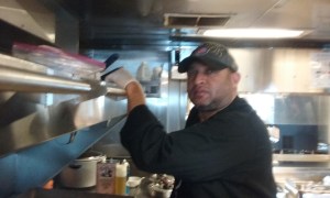
Ops Officer LT Manda taking photos of the Oscar Dyson – another ship in the NOAA fleet
ENS Lawler checking the course
The weather information center on the bridge
ENS Douglas doing the constant course check
On the long trip back, we were traveling through dense fog, narrow rocky passes in the middle of the night, and areas of high and sometimes unpredictable currents. We even managed a rendezvous with another NOAA vessel in order to pass of some medical supplies. Throughout all of it, I watched the NOAA Commissioned Corps officers handle everything with tremendous grace under pressure. But on Fairweather, I found out their work does not stop with the ship operations. Each of the officers are also directly involved with the hydrographic science, and have responsibility for a specific survey area.
The Survey team are also responsible for specific survey areas.
Survey techs Bekah and Drew at their computers. If they’re not eating, sleeping, working out, or on a survey boat – this is probably what they’re doing!
For each area owner, this culminates in a final report (called a Division Report, or DR) giving details of the survey and talking through all anomalies. Survey work does not stop. These folks are working 7 days a week and often 14+ hour days when they are out at sea.
In some cases the owner of a survey area will have very intimate knowledge of a survey area because they had the opportunity to be out on the survey boats. But in many cases, this will not be true. Ultimately their responsibility is making absolutely certain that every piece of necessary information has been gathered and that the data is clean. I was told that in most cases, writing the final report will take a couple months.
These reports will eventually become mapped data that is accessible to anyone through the National Centers for Environmental Information (NCEI). But it will also be sent in various forms to be housed for shipping navigation and other industries.
If you’re working long hours 7 days a week, you learn to take advantage of any opportunity you get to rest. A couple members of the survey team, catching a nap on the transit back from the Yukon Delta to Fairweather.
With all of the work they do at sea, ports can become very welcome places. The Fairweather crew had gone into port at Nome, Alaska several time through July and August and were excited to pull into Kodiak. Even on our transit south, I watched the crew get more excited as they left the desolation of the tundra and we began to see cliffs and trees again.
I am so glad that I saw the tundra finally, and that I will now be able to explain it more fully to my students, but I can also completely understand how the sheer vastness of the northern parts of Alaska could make you long for more varied terrain.
Harbors in Southern California don’t look like this!! Coast Guard Base harbor in Kodiak, AK
I only got to spend one day in Kodiak, but it is a breathtaking place. I didn’t get to do any serious hiking, but I did see the salmon running and ended up on an old nature trail. And the best part was that I got to see a bunch of amazing people relax and enjoy their time away from work.
Would I do this again if I had the opportunity? Unequivocally YES!! I would jump at the chance!
Would I recommend this to other teachers? Absolutely! It is an amazing experience. Granted, I think I had the best ship with the best crew…
Weather from the bridge: 48o F, 1-2 knot wind from, Completely overcast,
Executive Officer Michael Gonsalves in his overwhelming (because of all the things he does) office.
An Interview with XO (Executive Officer) Michael Gonsalves
How long have you been with NOAA?
I’ve been here for 13 years…I’ve been on the ship for about 6 months.
What brought you into NOAA?
Certainly I’ve always had an interest in the ocean and in the environment. One of my undergraduate degrees was in oceanography. So I think that’s what steered me towards NOAA. My other undergraduate degree was in math, so I liked the idea of being able to apply math in an environmental setting.
As a side note, XO Gonsalves also has a MS in Applied Math and a PhD in Marine Science
What is it that you do – what is the job of an executive officer?
The Executive Officer position is second in command. So if anything should happen to the CO (commanding officer) I would assume command. Though that is a contingency; that is not my actual job… All administrative work goes through me. For example, the budget, payroll, travel, performance, disciplinary actions, scheduling, arranging all port logistics, …getting augmenters to come out to the ship to fill in… I do everything to allow everyone else to do their job. My job is not the mission. My job is keeping the ship safe and logistically ready to execute the mission.
This is typically a step on the path to becoming a CO, is that correct?
Typically, that’s right. Usually the average NOAA Corps officer will have four sea assignments. Basically every five years, give or take, they will be going back to sea. The first will be as a junior officer, an Ensign. The second is as an Operations Officer who will be coordinating the mission [of that ship]. On the hydro ships that means coordinating the hydrographic science. The third sea tour will be as an Executive Officer and the fourth, around year 15, will be as a Commanding Officer.
I know that NOAA Corp officers spend roughly two years at sea and then three at a land billet. So what has your path been thus far?
I lingered in nearly all of my assignments by a little bit. My first assignment was here, on Fairweather, just after she was reactivated. It was a very skeletal crew. I had opportunities to be trained quickly. We only had two launches at the time. There were so few boats, there were so few people trained in doing things, it was in the crew’s best interest to qualify me because very few people were qualified to do anything.
My first land assignment was at the University of Southern Mississippi. It was a double billet. Number one, it was full-time university training. There was also working with an inter-agency group, The Naval Oceanographic Office and the Army Corps of Engineers, both also conduct survey operations. It’s a nice inter-agency group with similar issues and problems and we can share best practices and things like that. Their particular niche is airborne laser bathymetry, so they are working from an airplane.
Back to University of Southern Mississippi, what was the degree you were pursuing?
Initially it was a master’s degree as a one year program. As it happened, there was a project that I could work on of suitable interest to the joint LIDAR center. We all agreed that I could continue to work on it. The university felt that it was dissertation worthy. So I received my Ph.D.
What was your second tour at sea?
My second tour was as an Operations Officer on Fairweather’s sister ship, Ranier. All three of my assignments thus far have been on hydro ships. There is something to be said for that. It’s a little bit tricky to bring someone in from the outside. It’s a steep learning curve.
My second land assignment was working for the NOAA Operations Branch in Washington D.C. This is a part of the Hydrographic Surveys Division. They govern the field units on the large scale. So I was making the big decisions for what the hydro ships would be responsible for during that particular season. We determined what type of coverage would be needed in each area. That is then the information that the Operations Officer on the ship is working from.
What made NOAA so attractive to you?
Giving service to the US government was a big part. I happily pay my taxes. I appreciate having a police force and knowing that my meat is safe. So that was definitely a big part of it. But NOAA also has a unique mission that I found attractive. And the variety is important to me – just knowing that every couple of years the assignment will change.
And what is it that keeps you going while you’re out here at sea? Is there anything you miss or are looking forward to when this sea tour is complete?
People are tricky and a lot of my job involves personnel. The whole job keeps me going, really. I do miss Washington, D.C. – the public transport, the museums and the shows. There are so many things to do and see. There are a lot of jobs in D.C. and I am making clear that is a desire for the next land billet.
Junior officers, ENS Calderon and ENS Carroll on the bridge working on the computer navigation system. Both also are intimately involved with the surveying program.
A quick one question survey for the junior officers on the ship… Why did you choose a hydrographic survey ship? A collection of the answers I received are below:
To have the opportunity to be much more deeply involved with the science
My background is math or math/mapping
To be in Alaska
This is a route to pursue flying with NOAA Corps
Didn’t want the technical skills developed in prior work to go to waste
Had already worked on fisheries ships with Department of Fish and Wildlife
As with all officers in our uniformed services; NOAA Corps officers have had degrees conferred prior to service. Most of the degrees are math and science. The hydrographic survey ships tend to attract the math, physics, and geological science degrees for obvious reasons. Many then go on to pursue advanced degrees as did LCDR Gonsalves, the focus of my interview.
An interview with Kathy Brandts and Tyrone Baker; Ships Stewards
How long have you been cooking for NOAA Ships and what were you doing prior?
Chief Cook Tyrone Baker, master of the grill
T: I cooked for the Navy for 20 years out of school. When I finished, I went to work for a casino for a while – still cooking. Then NOAA called me up (he had put in an application a while before and forgotten about it) and here I am! That was back in 2005.
K: I started out in the Coast Guard…I wanted to be a bosun [boatswain] mate, which is what everyone wants to do. But it was going to take a long time to make grade, and hardly anyone wants to be a cook because it’s a lot of work. I decided to go through their school, which was two months. That was when it started, in ’94. My first ship assignment was the Polar Star, which was an ice breaker.
Kathy Brandts, Queen of the kitchen – also known as the Chief Steward. This is the day she let me cook a bit with her.
Kathy, why did you get out of the Coast Guard and what finally got you to NOAA?
K: All of the land assignments were being contracted out to [private companies]. So I was never going to get a chance to cook on land. So I decided that wasn’t for me. I got out after my four and a half years. I landed in Seattle, and that’s where NOAA was based. I had heard about them when I was in the Coast Guard. I knew they were hiring, talked with somebody, and essentially got hired on the spot. And I was in Alaska! I started out in the augmentation pool, I worked on Discovery and then on Ranier. Then a permanent position came up and I jumped at it. I didn’t really get along with the Chief Steward, though – so I left NOAA and worked for Keystone Ski Resorts in Colorado at their stables. [She spent several years on land at that point.]
The Chief Steward on Ranier tracked me down [in Colorado] and asked me to come back. There was talk of Fairweather coming back online and I wanted the Chief Steward job. I didn’t have the experience at that point, so I took a year off and went to Culinary School. I applied for the Chief Steward job on Fairweather and got it. I was on Fairweather from 2004-2013. [She is now the Chief Steward on Ruben Lasker, another NOAA ship, but is helping out on this leg]
Why be a ship cook?
T: I’ve been so many places and seen so many things I wouldn’t have otherwise seen. I’ve really been all around the world. I’ve been in almost every port of the world. How many people can say that? I wouldn’t trade it.
K: I was a restaurant cook for a while. I hated it. You’re either going 9 million miles an hour or there’s nothing. There’s a lot of alcoholism and drug use in that industry and they live a different life. The service industry… (laughs). And people are either sailors or they’re not. I think, much to my chagrin, I found it out after I quit the Coast Guard.
T: Yes, I agree. I’m a sailor. It was why I joined the Navy.
What are the best and most rewarding things about what you do?
T: I just really like it. I enjoy the cooking. I enjoy the work.
K: I like good food and I like when people are appreciative of what I do. And we’re all stuck out here together, why not make it the best that it can be. Meal time is what you look forward to when you’re on a ship.
GVA Dave – he just joined Fairweather and was actually helping out the stewards on this leg, but now he’s where he’s supposed to be in the deck department.
Crew member of the Day: Electronic Technician (ET) Charlie Goertzen
Charlie Goertzen, tech guy extraordinaire!
So today as we pulled into Kodiak, the news came in that the long awaited new televisions were here. Immediately, Charlie was notified. And he will work hours to make sure that each crew member has a working television in their room.
He is the guy that keeps the connectivity going in pretty difficult conditions. He has to spend a lot of time keeping various computer components talking to each other. He has to content with all of the complaints about lack of bandwidth, slowness of applications, slowness of wireless – and he does his best to keep things optimized and clean and efficient all the time. Two of the things he loves the most are the ocean and working with electronic components. He gets both of them all the time!
Location: 56o20.5N 166o07.1W (We are currently ~ 170 miles due east of the Alaskan Peninsular National Wildlife Refuge!)
Weather from the bridge: 51o F, Wind 8-10 knots from 285o, high thin clouds, seas 2-3 ft (1 hour after I wrote this we were socked in with fog, which is fairly common for this part of Alaska during this time of year.)
Science and Technology Log:
Fairweather was commissioned in 1968 and has 2 engines. The engines are pretty ridiculously big. They are diesel combustion engines and run similarly to a diesel tractor engine.
Karla Martinez standing next to one of the engines for scale. She is an oiler, and currently the only female member of the engineering crew. Go Karla!!
She was built with Controllable Pitch Propellers. This technology is fascinating!! It allows for very fine control of the ship’s motion.
An image of a CPP propeller with blades in two different positions to show the axis of movement. Image courtesy of Schottel website.
The CPP technology works by turning each of the propeller blades on its individual axis. In this way, the propellers never have to change the direction of spin, but instead the spin continues the same direction but the ship can come to a stop and then reverse direction. This differs from the fixed propeller system that is on the small launches. The Fairweather’s propeller blades are about 3 feet each in size for a total propeller diameter of 7 feet.
She also has a bow thruster which can be used in certain circumstances. The bow thruster enables the bow to move from side to side while the stern of the ship is static. It is essentially a propeller mounted into a tunnel/hole in the bow giving thrust perpendicular to the typical direction of travel. For a large ship like Fairweather, this is especially helpful when moving in and out of docking locations.
The next two technologies are of particular interest for my environmental science classes. Because the ship is often at sea for extended periods, it is necessary to make fresh water from the salt water. Typically Fairweather will take on ~16,000 gallons of water in port, but evaporators will be used to generate supplemental freshwater when it is needed.
This is the seawater intake for one of the evaporators.
The evaporators on Fairweather are flash (plate) evaporators and they can generate around 160 gallons of water per hour when operating optimally. The evaporators are running a distillation process by evaporating the water using heat from the boilers at a low pressure and then separating the freshwater from the brine (highly saline water). Because of the constant removal of salt from the water, the evaporators need to be cleaned often for best use.
This is one of the flash evaporators. Inside the pressure is lowered and the temperature runs at about 170 degrees F. While this is below the normal boiling point of water, the water will still vaporize and condense due to the low pressure
The brine is then discharged and the freshwater is added to the supply tanks. When leaving the tanks, it is pumped to higher pressure and further treated through filters and with UV light to kill off any bacteria that may have made it through. That water is stored in a hydropneumatic tank at high pressure so that water can be delivered to all parts of the ship without the need for continuously running pumps.
People eat and drink and then they pee and poop. They also like to shower and brush their teeth and wash their hands. They also need water to drink and cook with and to make coffee and tea. Obviously there is also a lot of gray water (sinks and showers) and black water (toilets) that is produced on a ship of this size carrying ~40 people. So what is done with all of it? Well, blackwater goes through the MSD (marine sanitation device) before it is discharged outside of 3 nautical miles from land. MSDs are standard on all ships and work similarly to land based sewage treatment on a much smaller scale. Gray water can be acceptably discharged as is in most places, but must be stored within NDZs or No Discharge Zones.
Guidelines for discharge
Other necessary technologies on the ship are the refrigeration system, the boilers and the generators. But I won’t go into all of those processes. It’s just amazing to me that there are so many things that must be accounted for on a ship if it will be at sea for multiple days!
Crew of the Day! Engineering
If you’re going to get pictures of the engineering crew, you have to find the rare times when lots of them are together… you can find a good group at mealtimes or when the ship is being docked and they all need to be on the boat deck! L-R: Sean, Kyle, John, Mick and RayL-R Sean, Connor, John, Mick, Alex, Eddie… and even with all my stealth, I’m still missing a couple from the group pictures!
The Engineering crew on this ship is a highly eclectic bunch! They are also a REALLY difficult group to get together for pictures. They have about a 40 year span in age and include folks from all over the world with a great diversity of backgrounds. There are several levels within the engineering crew. The entry level position is termed a wiper, next is an oiler, and then engineering utility, and junior engineer. These positions are unlicensed, analogous to enlisted positions in the military. The licensed positions are 3rd Engineer, 2nd Engineer, 1st Engineer and Chief Engineer. There are five licensed engineers on board right now and another six in the department who are oilers and junior engineers.
Anything that is mechanized, motorized, has an electric cable going to it, or needs to be oiled or lubed, those things all fall under the watchful eye of the Engineering crew. One of the young 3rd Engineers, Connor (nicknamed Titan because he really is giant) also describes them overseeing “Hotel Services” – plumbing, lighting, heating & cooling. The crew keeps a 24 hour watch whenever the ship is underway, and can take over aft steering if something were to fail with the bridge steering. They are also on watch whenever the small launches are being deployed or replaced to their cradles. If the bow thruster is being used, a crew member will also watch to see that it engages properly for use.
The well-being of the ship is in the hands of the Engineers and therefore the Chief Engineer reports directly to the Commanding Officer (where all other department heads report to the Executive Officer). The CO and the Chief Engineer really share the task of running the ship, but ultimate responsibility lies with the CO.
Personal Log:
The food! OH MY GOODNESS!!! The food on Fairweather has been terrific. There are two amazing cooks here currently. Tyrone, who is the Chief Cook, has been with Fairweather for 5 years. Prior to that, he cooked for the Navy. Kathy is the Chief Steward (which means she is in charge of the kitchen and develops the daily menus) and has been with NOAA ships cooking in some capacity for almost 20 years! You’ll learn more about her in my next blog… The Interview Issue!
So, here’s a sampling of what’s been on the menu since I’ve been here: Prime Rib, Lobster, Argentinian flap steak with Chimichurri, Halibut with some crazy good pesto type sauce… I am going to leave the ship about 10 pounds heavier than when I got here. So, this is not what you always get on NOAA ships, but this particular pairing of Kathy and Tyrone makes some serious magic!!
Geographic Location: Transit from Port Clarence to Yukon River Delta with Ship Surveying on the west side of Norton Sound
Latitude: 62o 32.5 N Longitude: 165o 48.7 W
Date: September 3, 2017
Weather on the Bridge:
48 degrees F, Winds 6-8 knots from NNE, Seas 2-3 ft increasing, 50% cloud cover
Science and Technology Log
AURORAS:
A shot of the aurora taken by Lieutenant Damien Manda, Operations Officer. This was my first aurora ever, and I know I was treated to a truly spectacular display. There was a lot of ooo-ing and aaah – ing and shrieks of delight. I was definitely one of those!
So this isn’t ship science, and it certainly isn’t technology that is made or operated by anyone on the ship, but the aurora is great science and of all the things I’ve experienced out here, has one of the best ties to Chemistry. Why Chemistry? Well, because it’s dealing with electrons. As my chemistry students will learn in a month or so, energy at certain frequencies has the ability to affect the electrons in an atom by causing them to jump up one or more energy levels. That electron does not want to stay in that higher energy position (orbital) so it will shortly drop back down. When it does so, it releases the absorbed energy as a photon of light which is what our eyes see as the brilliant colors. Neon lights follow this principle.
The aurora occurs in an oval shape around the magnetic poles of the earth – both north and south. The reason for this is that the magnetic field of the earth dips closer to earth at the North and South Pole. It is in these regions that highly charged electrons and protons from the solar wind move close enough to the earth that they will interact with the electrons in elements in our lower atmosphere; nitrogen, oxygen, argon and the trace gases.
Because each element has a different emission spectrum, the color given off will vary with the elements being charged. The green that is so often associated with auroras is from atmospheric oxygen. Oxygen in the lower atmosphere is the element that is most commonly affected by the solar wind particles. When higher altitude oxygen is affected, reds will actually be present. Nitrogen will also be charged this way, but less frequently than oxygen. Nitrogen’s color scheme is blues and purples. A strong aurora, which we had the opportunity to see, will have a mix of greens, pinks, purples, whites and blues.
ANEMOMETERS:Weather is one of the more important factors in determining ship navigation. High winds bring heavy seas; heavy moisture in the air may bring low clouds or fog reducing visibility. These factors must be figured into a navigational plan. Weather on the ship is compiled both through analog and digital means. The first wind information given to a seaman standing watch during daylight hours is the wind vane on the bow of the ship. It will tell which direction the wind is from and will give that seaman a sense of how the ship may drift off course while underway.
Looking up at the anemometers on Fairweather set on the flying bridge. You can see the two levels reasonably well. This is where constant weather data are being gathered which are then relayed to multiple places both on the ship and off.
The ship also has two anemometers. Both are on the mast. One is above the other physically as you somewhat see in the image. They are able to pick up exact wind speed and direction and keep record of maxima. One of the two will be chosen as dominant because the wind is less influenced by obstacles as it (the wind) travels across the ship’s surface. The anemometer chosen will feed into the ship’s digital data stream.The watch also takes data on air temperature, atmospheric pressure, cloud cover, and seas. Air temperature is taken from wet and dry bulb mercury thermometers. The difference between the wet and dry bulb temperatures will give a reading of relative humidity, also, when assessed using a psychrometric chart. A standard barometer is also on the bridge. Swell height and direction are determined by the watch crew visually, as are cloud cover and type. All of these data are recorded hourly. Digital sensors on board also take many of these readings and feed them into the navigation system and the ship’s ECDIS system. The redundancy of these processes, using both digital and analog means, underscore the importance of weather to the ship.
All NOAA ships, UNOLS (university ships) and some merchant vessels also serve as weather stations for the National Weather Service. The digital data is automatically sent on the hour. Visual data on swell direction and height and the condition of the seas is shared through another program, keeping the NWS and other weather agencies more informed of local weather activity.
ANCHORS:
Commanding Officer Mark Van Waes and Chief Bosun Brian Glunz checking the anchor and chain to be sure it is clear of the ship. Dennis Brooks is standing by.
When placing the anchor, the ship will initially overshoot the anchor location and then reverse back over it. This is primarily to keep the anchor and chain from ever being underneath the ship. The anchor and chain are extremely heavy and could do serious damage to the scientific equipment underneath, the propellers and even scratch up the hull. Once the ship has reversed slowly to the location, the anchor is dropped along with 5-7 times the amount of chain as the depth of water the ship is in. As the chain is dropping, the ship will continue to slowly back up laying the chain along the seafloor. The chain will then be locked, and as the anchor finally drags back, it will catch and hold. When the anchor catches, the ship will buck slightly, pulling the chain completely taut, and then because the ship will rebound, the chain will slacken. This is done twice (or more, if necessary) to ensure the anchor has really caught. The bosun and deck hands are watching over the side of the ship communicating with the bridge when the anchor is taut and slack as well. For complete safety, fixed points of land are marked on the radar and distances to each are calculated. The bridge will take measurements from these points every 10 minutes for the first half hour confirming that the anchor is set and then every half hour while at anchor.
Heaving the anchor involves “reeling” it in (similar to sport fishing) by getting the ship closer to the anchor as it is being drawn up. The goal is keeping the chain at a 90o angle to the surface of the water. Again, this keeps the anchor and chain from being able to do damage to the ship. During this process, the bridge will continually check the location of the bow relative to the anchor to insure that the hull will never cross over the chain. Once the ship is directly over the anchor, it should pull free. Finally, during the time the anchor chain is being pulled up, it must be cleaned of all the mud and debris.
Me. Washing down the anchor chain as it comes up with SS Dennis Brooks helping hold the fire hose (it’s pretty heavy!)
ADULT EXPOSURE SUITS:
Me trying on a VERY large adult exposure suit. Look at those legs!!
Each week, the entire crew of the ship has an emergency drill. Because there are no outside emergency personnel available for the ship (e.g. fire department) all crew must be well trained in how to handle fires, a sinking ship, and a person falling overboard. There are many crewmembers who pursued their MPIC (Medical Person in Charge), and others who are trained in Rescue Swimming, and there are also members of the Engineering crew who are trained firefighters. But regardless of training, the entire crew needs to be clear as to their responsibilities in an emergency situation and how to communicate with one another throughout the ordeal. So once a week, an unannounced drill will be run to sharpen some of these skills.
I had the chance to be involved with “man overboard” drill today. The drill consisted of me screaming as a dummy (Oscar) with a life vest was dumped over the side. After that, a man overboard was called and the ship’s alarm system was initiated. There are differing signals for each type of emergency. As all ship personnel mustered, communication began. The Commanding Officer, Mark Van Waes, was actually the first to spot the MOB (man overboard) and fixed the location for the bridge who subsequently relayed it through ship communications. At that point, two different options were available; bringing the ship to a position next to the victim and rescuing from the ship or deploying the Fast Rescue Boat mentioned in my last post to do a rescue. Although the ship was brought around, the rescue from the ship proved too difficult. The Fast Rescue boat was deployed with a coxswain, rescue diver (outfitted in an exposure suit) and a third. The MOB was found, placed on a back board, brought back to the ship, and rescue breathing was started along with warming up of the body.
It was fantastic watching all of the different pieces of the puzzle come together to be successful.
Department of the Day: The Deck Crew!
The amazing deck crew! L-R back row: Terry Ostermeyer, Dennis Brooks, Brian ____. L-R front row: Carl Coonts, Rick Ferguson, Me, Peter “Nick” Granozio
Every department is important on Fairweather, but the deck crew does a lot of difficult tasks that are often overlooked. They are the ones who keep the ship clean and stocked with supplies. They do the heavy lifting and the fixing of anything non-mechanical. They are responsible for driving the small launches – and are indispensable to the surveys since they need to drive the lines and make the call if it gets too shallow or dangerous. They are also on bridge watch and typically have the helm, meaning they are driving the big ship, too!
Deck crew launches the small boats from Fairweather and they head up the line handling to keep everyone safe. Members of the deck crew are also on watch 24 hours a day and do constant security checks throughout the entire ship every hour. They operate all of the cranes onboard. They are responsible for the flow of materials – what will be incinerated or placed in hazmat containers or stored for later disposal – and then take care of it. Finally, they also do the physical work of anchoring and heaving the anchors. The ship certainly would not run without the deck department.
Personal Log
Getting to know the different groups of people that work here has been amazing. I’ve had opportunities to work closely with the Survey team, the NOAA Corps officers, the stewards and the deck department. I’ve had a chance to see a bit of what the engineering group does, too. I’ve learned so much about the work they do and even about the lives they led before and lead now. I’ve also learned that ship life has some big ups and downs. The work is fascinating and most of the time there are new and interesting things to do. The CO, XO and Ops Officer work hard to ensure that daily duties change often and that there is a constant atmosphere of training.
But it’s difficult to be out at sea for long periods of time, and Fairweather in particular does not have a true “home port” – so it’s virtually impossible to have a place to call home. Several of the folks on this ship have family around the area of where Hurricane Irma is about to hit (Florida, the Carolinas…) and so one of the crewmembers is on his way to Florida to make sure everything is going to be okay. On the flip side, you really do get to see amazing places and events – like the aurora at the top of my post, or Russia…
The islands of Little Diomede (left, foreground) and Big Diomede (right, background). Little Diomede is American land but Big Diomede is Russian. I saw Russia!
Did You Know?
…that exposure (immersion) suits really do extend your life? In March 2008, up here in the Bering Sea, a fishing trawler, Alaska Ranger, went down with 47 people on it. All 47 put exposure suits on prior to abandoning ship – some of them were not properly fitted, one ended up with a gash in it – but at least they all put them on. While lifeboat deploys were attempted, at least two of the lifeboats ended up floating away with no one in them. Only 2 were properly deployed and one of those took on water immediately. So exposure suits were the primary survival tool! Although 5 members of the crew did not make it, 42 were saved through the actions of the US Coast Guard and others in the 1-7 hour window after hitting the water. Some of the crew members were floating in the water in their suits for 3 hours before they were rescued! The necessity of proper training, like the weekly drills on NOAA ships, cannot be overstated. But in these worst case scenarios, even an ill-fitting exposure suit is going to give you more time.
Late afternoon: full cloud cover, rain squalls, 10-14 knot winds, 41 degrees
Science and Technology Log
Thursday’s science was a bit different. Two boats went out to do some final surveying and follow up in Port Clarence and Grantley Harbor. Because the area of Grantley harbor to be surveyed was in less than 4 meters of water, an Ambar jet boat was used with a single beam sonar mounted aft on the port side. The second boat that went out was one of the small launches for use as a dive boat for NOAA trained divers (https://www.omao.noaa.gov/learn/diving-program). The goal of the dive boat was to dive on a particular location in Port Clarence that was giving a strange image that must have been coming from a man-made structure. The sonar showed a grid pattern roughly 100m x 60m with lines 7-8m apart on the long axis and 5-6m apart on the short axis. The team felt strongly that they needed to understand what was there in order to determine if it was safe for anchoring. I’ll follow up more on this later…
I went out with the team on the Ambar. As is the case with all the small launches, the Ambar is brought down from the boat deck to the breezeway deck for loading before the actual release.
Ambar jet boat at the breezeway deck, loading supplies. You can see parts of the davit where it was previously cradled on the boat deck above.
All gear, materials, food (long days out there!!) and people embark prior to the final drop to the water and the actual launch. This takes a team of a dozen or so people working in coordination. Prior to the start of launch, a safety officer is required on deck to oversee the process. This might be the CO (Commanding Officer), XO (Executive Officer) or Operations Officer. Most of the other personnel involved are a part of the deck crew, including the coxswain (who drives the small launches). A davit operator handles the control of the boat via cable(s) all the way down. The bosun (boatswain) on the breezeway deck is directing commands to the operator using hand signals. Several hands are securing the craft with ropes against the side of the ship. All of these moves have to happen in perfect coordination for the safety of everyone and the protection of the Ambar and Fairweather. Personal protective equipment is worn by all parties throughout. This includes a flotation vest or jacket and a hard hat which you can see on those on the boat in the image to the left.
Five of the other six small launches on the Fairweather undergo a similar process. Each is housed in a davit cradle and each has one or more cables to control the craft during its descent toward the waterline. The davits all shift their cradling position while the cables lift to assist in the release of the craft. Once the craft is entirely free of the cradle, it is slowly lowered down the side of the vessel to the breezeway deck for loading as described above. One boat, though, has a really cool option. This is the FRB or Fast Rescue Boat. This craft can actually be launched by the driver, which is a requirement of any FRB.
Workboat on the fantail – note the three lines attached, two at the stern and one at the bow. These are handled expertly by the deck crew during launch to keep her true.
The final craft is a workboat which is housed on the fantail. It is not used for surveying, but will often be employed as passenger transport. It is also used for pick up and drop off of material that may be used on land, such as the HorCon station discussed in my previous post. This craft is not seated in a davit cradle and is instead launched through the use of a very large crane (see image below). The crane is attached to the launch at a center point connected with three lines.
Crane on the Fairweather boat deck centered between four small launch davits.
The craft is moved from the position on the fantail to either the port or starboard side level with the deck and lowered to the water before loading. For this reason, it is much more difficult to keep it completely horizontal and not hitting the deck and doing damage to the Fairweather.
So back to the Ambar and what we were actually doing in Grantley Harbor. Much of the harbor is quite shallow and when a team had been in there previously, they felt that there may be some irregularity to the otherwise uniform seafloor. They had been getting some interference and scattering on the side scan. They wanted to understand why and also to get a complete picture of the harbor seafloor. With the Ambar and the single beam sonar, there is little to no danger of doing damage in extreme shallows since the equipment is not on the underside of the boat and the Ambar itself can be beached as there are no propellers.
Single beam sonar in its mount on the stern of the Ambar. It is in the down position as it will be when launched tomorrow.
We took the boat into the shallows with the single beam sonar to take measurements along lines to as shallow as 2m. While surveying in the shallows, we found that there were sea grasses growing and according to the Operations Officer who was on board, that may have been the reason for the interference. Regardless, we continued to survey a regular pattern in order to have good data for future charts. During this time, I was given the opportunity to drive the Ambar… which showed me how much more difficult staying a straight line course is than the coxswains make it look.
Yep. The outlined line is my line. I am reasonably proud that I actually manage to make it from one side to another. But even that was with a WHOLE lot of coaching!!
Upon return to the Fairweather, the Ambar is reattached to the cable and brought back up to the breezeway deck. Ropes are again used in coordination to keep the boat steady as it is lifted, much the reverse of what was described above. At that point all materials are unloaded and all the people disembark. The Ambar is then hoisted back up into the davit cradle.
When I’m back in an area with lots of bandwidth, I’ll create a video post to show just how cool the launches of small boats really is…
Personal Log
Shipboard life on a NOAA vessel is quite different from life on land. First, because the ship is a twenty four hour operation, people are needed at all hours. Many of the positions on NOAA vessels run on a 4 hours on, 8 hours off cycle. Some positions have recently shifted to 4 on, 4 off, 4 on, 12 off to afford greater lengths of time for sleep. When you are on the lower decks, it is also easy to lose track of time – and of course when you’re in Alaska during summer, it’s still light out at 10 o’clock. There are auroras to potentially be seen in the wee hours and multibeam surveying that happens through the night. There are always people up and about doing things – so the ship is a busy place at all times.
And with this in mind, I have to admit I have not been doing a great job getting to sleep. But I do sleep well on the ship, the rocking is the best cure for insomnia I’ve ever experienced. And I have been eating incredibly well – and I mean INCREDIBLY well. Mealtimes are the same each day, so that’s a great help. I will talk more about the food and the kitchen in a future post. Fortunately, with all that good eating, there’s a gym on board, so I’ve been able to work some of it off. There’s also laundry on board and a lounge with lots of movies. I like it. And waking up to the ocean and a lovely sunrise each morning makes the tiredness not really matter much.
Light early in the eastern sky – the sun comes up all around you this far north. It’s truly lovely.
As a part of NOAA’s mission, we had the opportunity to go ashore at a small town at Port Clarence called Brevig Mission. It is a town of almost 400, most of whom are native to Alaska. While ashore, we were able to spend time talking with the people, purchasing some of their handcrafts and fish, and even visiting the school. The people live simple lives. They still hunt walrus, seal and whale and those foods are the staple of their diet through the frozen winter months. I found it fascinating that they use all of the parts of the animals – the items that I purchased were from seal and walrus.
On the left is an ornament made of seal fur and on the right is a pendant of walrus tusk.
The CO (Commanding Officer) also arranged for ship tours for people from the town. The folks were taken in the Ambar out to the Fairweather in small groups and shown around. It was fun speaking afterward with those who went – there was a lot of excitement! I am so grateful that I had the opportunity to go to the town. They have a crazy history (see the “Did you know?” section below.)
Mom with her two little girls down near the water on their ATV. This is the most common form of transport around Brevig Mission.
Did You Know?
This cross memorializes all of the residents of Brevig Mission who died in the 1918 flu. It now lays on the ground aside the mass grave. All of the names and ages of the victims are listed.
Brevig Mission was hit hard by the 1918 Spanish Flu, perhaps in percentage mortality, the hardest hit place in the world. Of the 80 residents of Brevig Mission, 72 succumbed to the flu and died in a 5 day period. It was absolutely devastating. One of the current residents shared with me that reaching 400 is encouraging to the town and everyone there believes that the town is continuing to grow.
This is the location of the mass grave from the 72 flu victims of the 1918 Spanish Flu. It is a sobering place.
In 1997, the lungs of a well-preserved victim in the mass grave were shipped to a molecular pathology lab in Washington, D.C. and the flu virus was reconstructed. The evidence showed that it was a bird flu (similar to the avian flus which plague our world today) but incredibly virulent as it passed from birds to humans. You can read more about the findings here. (http://www.gi.alaska.edu/alaska-science-forum/villager-s-remains-lead-1918-flu-breakthrough)