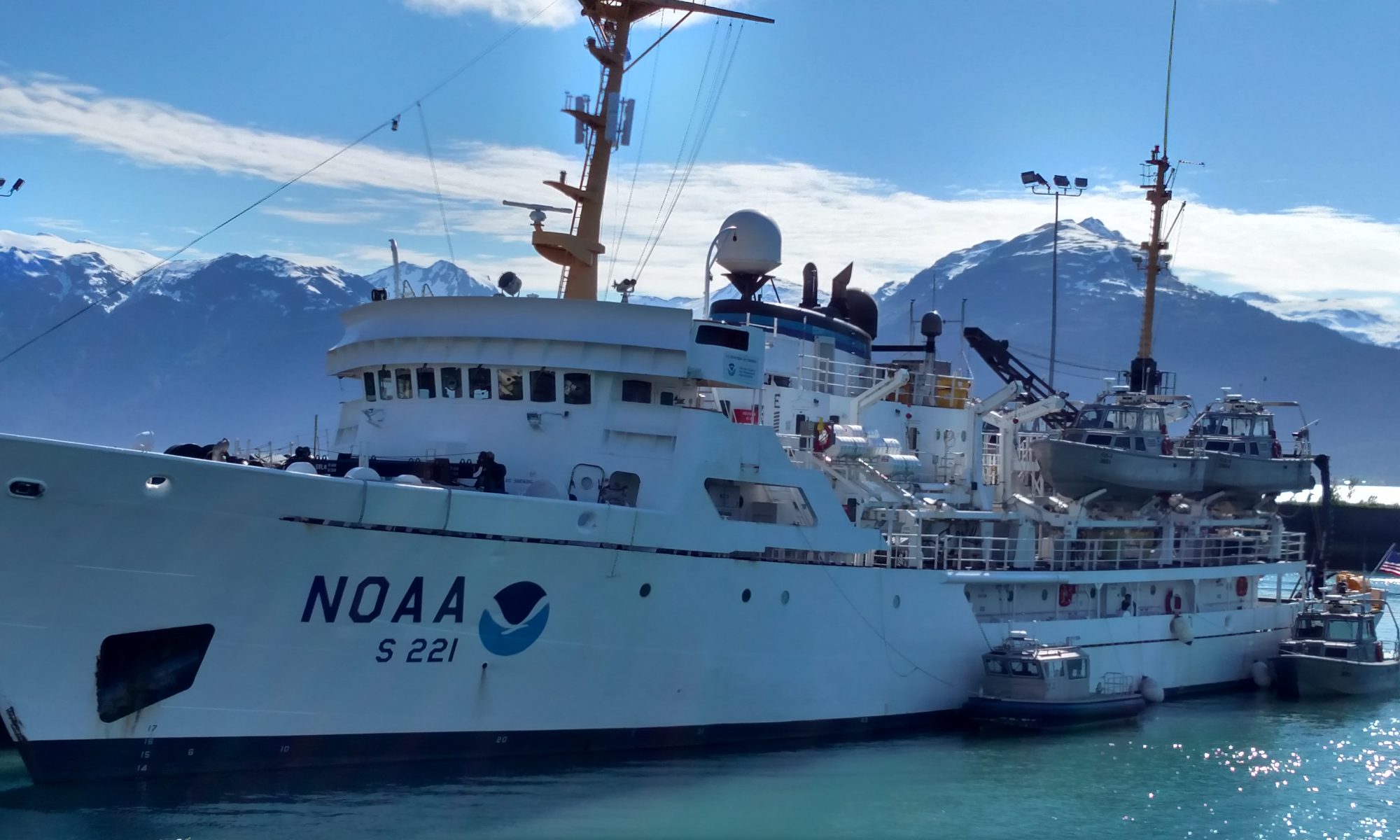
Jessie Soder: Geology on Georges, August 17, 2011

NOAA Teacher at Sea
Jessie Soder
Aboard NOAA Ship Delaware II
August 8 – 19, 2011 

Mission: Atlantic Surfclam and Ocean Quahog Survey
Geographical Area of Cruise:  Northern Atlantic
Date: Wednesday, August 17, 2011

Weather Data
Time: 12:00
Location:  41°19.095 N, 71°03.261
Air Temp:  22°C (°F)
Water Temp:  21°C (°F)
Wind Direction: South
Wind Speed: 7 knots
Sea Wave height:  0
Sea Swell:  0

Science and Technology Log
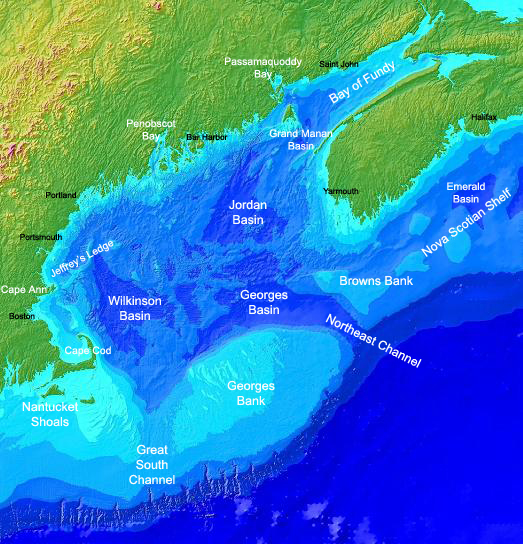
Gulf of Maine: Including Georges Bank

So far, we have spent this entire trip on Georges Bank.  This famous geographical location off the east coast of the United States is something that I had only heard about before this trip.  After several tows over the past week I have been able to see a variety of materials brought up from the ocean floor of Georges Bank.  I have seen loads of clams, empty shells, sand, mud and clay, and smooth polished rocks.  We have even pulled up a few boulders that must have weighed a couple of hundred pounds.  It was the smooth polished rocks that caught my attention. How would a rock from the bottom of the ocean become smooth and rounded?  It probably meant that Georges Bank must not have always been the bottom of the ocean.

During the Wisconsin Glaciation the ice reached its maximum around 18,000 years ago.  The Laurentide ice sheet paused in the area of Georges Bank and Cape Cod and left behind a recessional moraine that created these landforms.  This ice also had several meltwater streams flowing from it and these streams were responsible for the polishing the rocks and cutting some of the canyons found on the seafloor today.  The Northeast Channel off the northeast side of Georges Bank was the principle water gap for most of the meltwater.

Smooth Polished Rocks From the Ocean Floor

Georges Bank is a huge oval-shaped shoal bigger than Massachusetts that starts about 62 miles offshore.  It is part of the continental shelf and its shallowest areas are approximately 13 feet deep and its deepest areas 200 feet.  In fact, thousands of years ago Georges Bank used to be above water and an extension of Cape Cod.  About 14,000 years ago the sea rose enough to isolate this area and it was home to many prehistoric animals such as mastodons and giant sloths.  Today, traces of these animals are sometimes found in fishing nets!  These animals died out about 11,500 years ago when the sea level rose further and submerged the area.

Georges Bank is a very productive fishing area in the North Atlantic.  (The Grand Banks is more productive, but not as geographically accessible as Georges Banks.)  Why is Georges Bank a prime feeding and breeding area for cod, haddock, herring, flounder, lobsters, and clams?  It has to do with ocean currents.  Cold, nutrient rich water from the Labrador Current sweeps over the bank and mixes with warmer water from the Gulf Stream on the eastern edges of Georges Bank.  The mingling of these two currents, plus sunlight, creates an ideal environment for phytoplankton, which is food for the zooplankton.  In fact, the phytoplankton grow three times faster here than on any other continental shelf.  All of this plankton feeds the ecosystem of fish, birds, marine mammals, and shellfish that flourish on Georges Banks.

Personal Log

Yesterday we left Georges Bank for stations off the coast of Rhode Island.  After dark, I stepped out on the back deck and Jimmy pointed out the lights of Nantucket and Martha’s Vineyard.  We were in sight of land for the first time in a week.  It wasn’t long before people had their cell phones out and were making calls.

A few times during this trip I have thought about sailors in the past and how they would leave for months, and even years, at a time and not have contact with their families and loved ones until they returned.  I have had email contact this entire time, yet I am really excited to go home to see those that I miss.  I can hardly imagine what it would be like to be gone for a year with no contact at all.

Throughout this trip I have been getting to know others on this cruise.  I have learned that several of them have families and young children at home.  Many of them are at sea for many weeks, or months, a year.  After being on this cruise, I have gained a lot of respect for people who choose to work on the ocean for a living.  It takes a certain type of person who can work hard, maintain a positive attitude, and live away from their home and loved ones for extended periods of time.  It has been an honor to work with these people.

Jessie Soder: Drag It Along, Dump It Out, Count ‘Em Up, August 14, 2011

NOAA Teacher at Sea
Jessie Soder
Aboard NOAA Ship Delaware II
August 8 – 19, 2011 

Mission: Atlantic Surfclam and Ocean Quahog Survey
Geographical Area of Cruise:  Northern Atlantic
Date: Wednesday, August 14, 2011 

Weather Data
Time:  16:00
Location:  41°47N, 67°47W
Air Temp:  18°C  (64°F)
Water Temp:  16.5°C  (62°F)
Wind Direction:  SE
Wind Speed:  6 knots
Sea Wave height:  0
Sea Swell:  0

Science and Technology Log

A fellow volunteer, Rebecca, and myself measuring clams

When I found out that the Teacher at Sea trip that I would be on was a clam survey, I thought, “Oh, clams.  I see those on the beach all the time.  No problem.”  I learned that the clams are collected using a hydraulic dredge.  I knew  that a dredge was something that you dragged along the bottom of the ocean.  That seemed simple enough.  Drag it along, dump it out, count ‘em up, and you’re done.

Quickly, I learned that this project is not that simple!  A few questions came to mind after we had done a couple of tows:  How many people are needed to conduct one tow for clams and quahogs? (operate the machinery, the ship, sort through a tow, collect the data, etc.)  How many different jobs are there during one tow?

Sorting through contents of a dredge

Those questions are hard to answer, and I don’t have a precise answer.  What I have learned is that it takes a lot of people and everyone that is involved has a job that is important.  I asked the Chief Scientist, Victor Nordahl, how many people he preferred to have on a science team per watch.   He told me that it is ideal to have six people dedicated to working on sorting the contents of the dredge, processing the catch, and collecting data per watch.  Additionally, he likes to have one “floater,” who can be available to help during each watch.  This seems like a lot of people, but, when there is a big catch this number of people makes the work much more manageable.  There are six people, including myself, on my watch.  Four of us are volunteers.

Each time the dredge is lowered, pulled along the ocean floor, and then brought back onto the ship it is called an “event.”  In my last post I included a video of the dredge being hauled up onto the deck of the ship after it had been pulled along the bottom.  An entire tow, or “event,” is no small feat!  During my watch Rick operates the machinery that raises and lowers the dredge.  (Don’t forget the dredge weighs 2500 pounds!)

There are also two people working on deck that assist him.  (You can see them in the video from my last post.  They are wearing hard hats and life vests.)  Additionally, an officer on the bridge needs to be operating and navigating the ship during the entire event.  There are specific times where they must speed up, slow down, and stop the ship during a tow.  They also have to make sure that the ship is in the correct location because there are planned locations for each tow.  Throughout the entire event the science team, deck crew, and the bridge crew communicate by radio.

Rick, in front of the controls he uses to lower and raise the dredge

As I said, this project is not simple!  To make it more complicated, equipment often breaks, or is damaged, which means that the deck crew and the science team have to stop and fix it. On this trip we have stopped to fix equipment several times.  Various parts of the dredge get bent and broken from rocks on the ocean floor.  Before the dredge is lowered, the bottom is scouted with a depth sounder to try to avoid really rough terrain.  On the screen of the depth sounder different substrates are shown in different colors.  For example sand is shown in green and rocks are shown in red.  We try to avoid a lot of rocks.  However, all the rocks cannot be avoided and sometimes we hit them!

Personal Log

Vic getting a hair cut

Before coming on this trip I was told that the work can be strenuous and, sure enough, it is.  Sometimes a tow brings up hundreds of pounds of rocks (with some clams mixed in!) that we need to sort through and, as you know, rocks are heavy!  The work is also a bit, well, gross.  We have to measure all the clams, whole and broken and we also have to collect weights of “clam meat.”  That means that we have to open the shells and scrape the meat out.  I have a pretty high tolerance for gross things, but I am starting to grow weary of clam guts!

In between tows there is a little bit of down time to catch your breath, drink coffee and eat cookies, watch the ocean, and read a book.  During one of these breaks, the Chief Scientist Victor Nordahl, took the moment and had his hair cut!

Jessie Soder: Happy as a Clam, August 12, 2011

NOAA Teacher at Sea
Jessie Soder
Aboard NOAA Ship Delaware II
August 8 – 19, 2011 

Mission: Atlantic Surfclam and Ocean Quahog Survey
Geographical Area of Cruise:  Northern Atlantic
Date: Wednesday, August 12, 2011 

Weather Data
Time:  12:00
Location:  41°47.405N, 67°21.702W
Air Temp:  18.4°C  (65°F)
Water Temp:  17°C (63°F)
Wind Direction:  South
Wind Speed:  8 knots
Sea Wave height: 1 foot
Sea Swell:  2 feet

Science and Technology Log

TK holding a monkfish caught in the dredge

When I was a little girl I was always excited to pull the minnow trap up from the end of the dock to see what oddities I had caught accidentally while trying to trap minnows.  I am reliving this excitement on a much larger scale on this research cruise.  The dredge we are using to fish for ocean quahogs and surfclams is 5ft x 20ft, weighs 2500lbs, and is pulled for ¼ nautical mile each time it is towed.  (That means it covers an area of about 9000 square feet.)  As you might imagine it accidentally catches things besides the ocean quahogs and the surfclams that we are fishing for.

The dredge is lowered into the water off the back of the ship.  Once it hits the ocean floor a powerful jet of water is sprayed into the ocean floor in front of it to “liquefy” the sand or mud on the ocean bottom.  This loosens the clams and suspends them in the water, just above the bottom.  (Ocean quahogs and surfclams aren’t far below the bottom; just a few inches.)  Then, while they are suspended in the water the dredge scoops them up.  The dredge is brought back up to the ship and dumped and we sort through the catch.  The ocean quahogs, surfclams, and a few other species are kept to weigh and measure.  Below is a video of the dredge being hauled back on the back deck of the ship.

After three watches I am getting pretty good at identifying ocean quahogs and surfclams.  What is the difference between an Atlantic surfclam and an ocean quahog?  Well, they are very similar!  They are both bi-valve mollusks, which means that they have two shells covering a soft body.  They both burrow into the sand so that only their siphon sticks out.  Both of them filter their food, algae and plankton, through their siphon.  One of the biggest differences between them is in the way that their shells connect, or hinge together.  Another difference is their lifespan.  The ocean quahog lives for more than 150 years and the Atlantic surfclam lives for approximately 30 years.  Their size and shape are different too.  Ocean quahogs are rounder than the Atlantic surfclams, which have a triangular shape.  The  Atlantic surfclam also grows larger than the ocean quahog.

Ocean Quahog (left) Atlantic Surfclam (right)

Just like I was excited as a kid to find crayfish and bullheads in my minnow trap I am excited to see what the dredge brings up each time.  So far our biggest catch was 4400 quahogs!  Conversely, our smallest catch was just three quahogs! Sometimes the dredge is filled with empty shells, or empty shells and sand dollars, or thousands of clams, or sometimes it is really sandy.  Each time it is a surprise and it gives you a brief glimpse of what the bottom looks like.

Personal Log

Empty shells and sand dollars

There are many potential dangers that you can face every day while working on a ship.  In fact, since being aboard we have run three drills; man overboard, fire, and abandon ship.  These drills are run on every trip so that everyone knows exactly what to do.

I think that there is something about being at sea on a ship that heightens your awareness of yourself.  I have experienced that same sort of feeling when I am sea-kayaking in big water, or hiking on a bear trail.  It is the feeling that there is something out there that is bigger than you are.  You sense things in a much clearer and acute way.

This evening the sun was going down on the starboard side of the ship and the moon was coming up on the portside.  We could see for miles and miles.  Earlier today we watched a school of tuna swim past and dolphins in the distance.  It was a beautiful clear and sunny day and we were 140 miles from land.  We are lucky.

Questions to Ponder

The clams and quahogs are collected on this research cruise from the sea floor using a hydraulic dredge.  The dredge is lowered and run along the seafloor for about 5 minutes in order to pick up the clams and quahogs.  Each time this is done it is called a “tow.”  How many people do you think are needed to conduct (operate the machinery and collect the data) one tow for clams and quahogs?  How many different jobs are there during one tow?

Jessie Soder: Introduction, August 1, 2011

NOAA Teacher at Sea
Jessie Soder
Aboard NOAA Ship Delaware II
August 8 — 19, 2011

Mission: Clam and Quahog Survey
Geographical Area: North Atlantic
Date: August 1, 2011

It is hard to leave Alaska in the summer, but on Friday I will  be leaving my home in Gustavus, Alaska, to travel to Woods Hole, Massachusetts.  Last February, I found out that I was chosen to participate in NOAA‘s Teacher at Sea Program and on August 8th, I will be joining Leg 3 of the Atlantic surfclam/ocean quahog survey on NOAA Ship Delaware II.   This survey helps scientists to determine the distribution and abundance of Atlantic surfclams and ocean quahogs.

Students Collecting Data on a Dark November Day

Living and teaching in Southeast Alaska has provided me with several opportunities to learn about and spend time on the ocean.  However, this will be my first time on the Atlantic Ocean and I am really excited.  It will also be my first time on a large research ship.  The NOAA Ship Delaware II is 155 feet long.

Not only am I excited, but my students are too.  They love the ocean and learning about the animals that live in it.  I teach all subjects to a multi-age class of 3rd, 4th and 5th graders.  Last year we spent a lot of time at the beach exploring the intertidal zone and collecting data about the animals that live there.  (My students were conducting a year-long study and shared their field reports and photos on their blog.  Check it out:  Gustavus 3rd-5th Grade Blog)    Needless to say, they are just as excited as I am to learn about all the animals that I will be finding during the Atlantic surfclam/ocean quahog survey.  We are all curious to learn about the similarities and the differences between the Atlantic and the Pacific Oceans.

Alaskan Sea Stars

Jennifer Goldner: Ready to Sail, August 2, 2011

 NOAA Teacher at Sea
Jennifer Goldner
Aboard NOAA Ship Oregon II

August 11 — 24, 2011

Mission: Shark Longline Survey
Geographical Area: Southern Atlantic/Gulf of Mexico
Date: August 2, 2011

If you asked me 35 years ago, “Who is your hero?”  My reply would’ve been, “Wonder Woman.”  If you asked me the same question today, my answer would be “lifelong learners.”  It is due to these people that solutions are being found for clean water, that animals are being saved, and that people are being educated at just how fragile our earth is right now.  NOAA (National Oceanic and Atmospheric Administration) is full of such people (Jennifer Hammond, Liz McMahon, Rob Ostheimer, Elizabeth Bullock, for starters).  I have been in contact with each of these individuals.  They have one thing in common: a passion about learning.  To this end, NOAA has a Teacher at Sea program. This season over 30 were chosen out of the United States.  Each of us will be on a different voyage. This is where I come in because I am a 2011 Teacher at Sea.  So, who am I?

Jennifer Goldner, NOAA Teacher at Sea

My name is Jennifer Goldner.  I teach 5th grade science in Room 8 in Jay Upper Elementary School in Jay, Oklahoma.  Our town is small in size, but we have big ideas.  If we don’t have resources, we find a way to get a project done.  Here are just a few of the things we have done: our class has been featured in Popular Science and on Channel 6 News; we’ve worked with U.S. Satellite and Laboratory and NASA; and we’ve designed and built a tree house.  We recently took a trip to Space Camp where we took home top honors of having the highest accuracy in completing our missions. 

Speaking of mission, let’s get down to business: my NOAA Teacher at Sea assignment.  Though I have been to the ocean, I have never sailed on a ship. 

Take the poll to tell me if you have traveled on the ocean. I will be traveling aboard the Oregon II in the Gulf of Mexico, August 11-24th.

Oregon II
NOAA Ship Oregon II

There are 3 main types of ships:   1. fisheries research ship, 2. hydrographic survey ship, and 3. oceanic and atmospheric ship.  I am on the most physically challenging of all the cruises: the fisheries cruise.  I, along with the crew, will be doing 12 hour work shifts.  We will be doing a shark and snapper longline survey.  I am privileged to be studying with Chief Scientist Mark Grace.  His work precedes him.  I have already been told he is top notch.  He is the Shark Unit Leader.  I cannot wait to learn from him!  The crew consists of about 30 people, including officers, fishermen, deck crew, engineers, electronics crew, cooks, scientists, and 1 teacher (that would be me). NOAA Ship Oregon II, also referred to as “O2”, is headed by Commanding Officer, Master Dave Nelson.  Again, I have heard rave reviews about him.  I am anxious to meet him in person!

As for my travel plans, I will fly in to Jacksonville, Florida.  I will then spend the night on my new “home away from home,” NOAA Ship Oregon II, in Mayport, Florida.  We will depart on August 11th and sail around the entire coast of Florida. O2 will travel to Pascagoula, Mississippi, arriving on August 24th.  You can follow us on the Ship Tracker.

Current Cruise (8-2-11) for Oregon II on The Ship Tracker
Current Cruise (8-2-11) for NOAA Ship  Oregon II on The Ship Tracker

While at sea I will be posting 2-3 blogs a week.  Please join in on our polls, read along about our voyage, and post comments and questions.  Let’s show NOAA that we are lifelong learners who value the importance of oceanic research.  Besides, if you have read this entire blog entry, that makes you my hero.