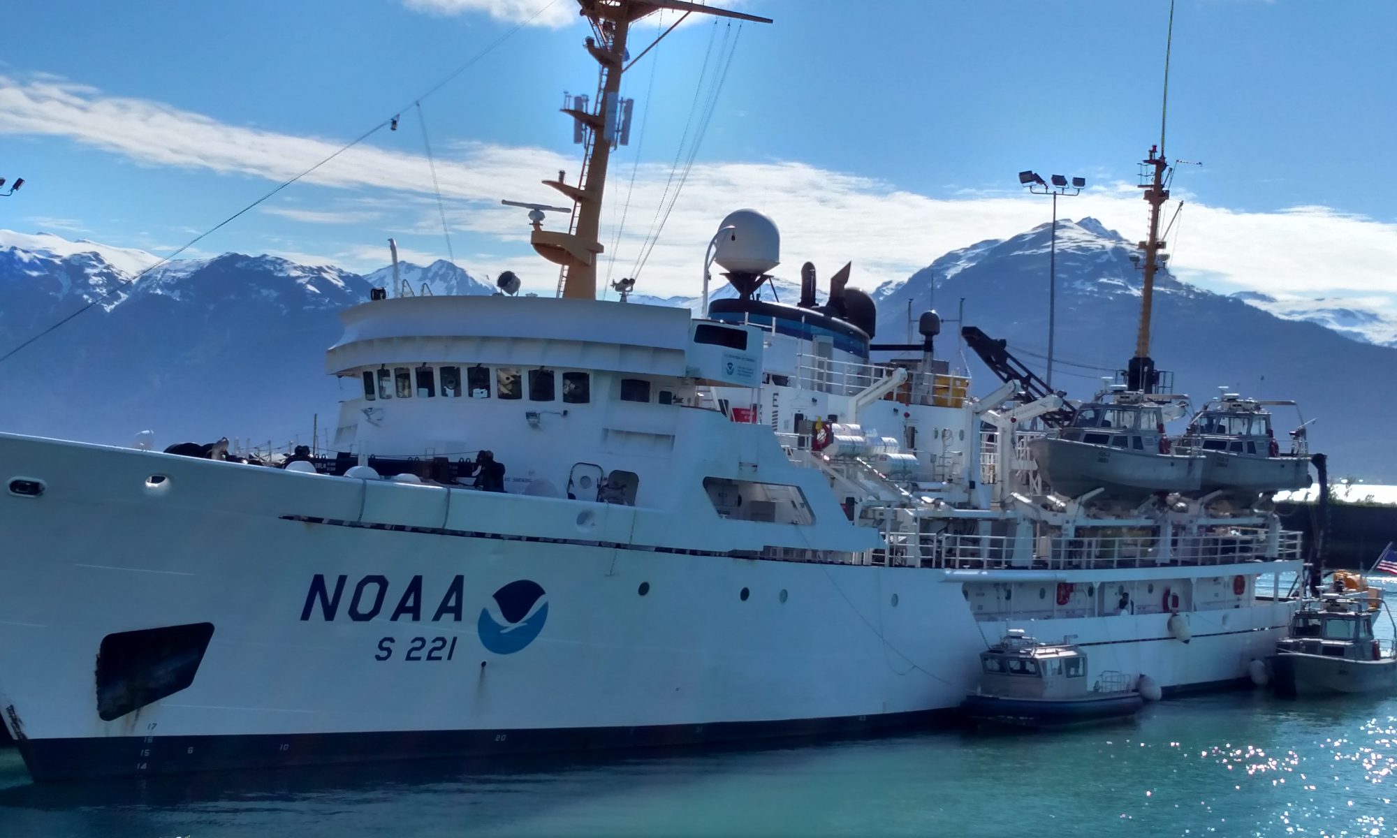
James Miller, August 17, 2005

NOAA Teacher at Sea
James Miller
Onboard NOAA Ship Rainier
August 13 – 27, 2005

Mission: Hydrographic Survey
Geographical Area: North Pacific, Alaska
Date: August 17, 2005

Weather

Sky: Clouds and rain, low 60’s
Wind: 10-15 kts.
Seas: 6 – 8 foot
Itinerary:  Should arrive in work area tonight (9:30pm). Anchor in Fish Range Bay on peninsula.

Science and Technology Log 

Went up to the bridge last night prior to going to bed.  There’s usually an officer and three crew on a rotating four-hour shift schedule.  It’s reassuring that there is so much redundancy regarding navigational equipment.  The officer on duty (OOD) is constantly checking our position on the chart and comparing it to the radar, and GPS chart plotter. He also does some quick time, distance, speed calculations to determine where we should be at half hour increments, these he marks on the chart (good lesson potential).

We also had a good conversation regarding compass headings.  Typically, smaller boats navigate using magnetic compasses and therefore always steer toward magnetic north. The problem with magnetic north is that charts use true north (north pole) and depending where you are in the world there is a deviation between true and magnetic north (close to 20 degrees where we are). The ship is fitted with both magnetic and gyrocompasses.  The gyro compass points towards true north but requires power.  The ship uses the gyrocompass to navigate but would have to fall back on the magnetic compasses if the ship lost power (which is highly unlikely).

I met with LT Ben Evans and Commanding Officer Guy Noll after lunch for a briefing. They were interested in what specific classes I teach, and the things I wanted to get out of the cruise. They also briefed me about the RAINIER’s mission and where we would be working. They showed me a chart in and around Mitrofania Island.  Charts will typically have depth soundings (in fathoms) every ¼ inch or so.  The map they showed me had a lot of white space with only a few limited depth soundings.  The reason for this is because the area is literally uncharted.  Very few ships or even fishing vessels come into the area because, in Alaska, the ocean bottom rises very quickly and they are concerned about running aground. This is where the RAINIER comes into play.  Its mission is to collect the data to eventually be put on charts.  It sounds like an easy task, however, the process is very complex and lengthy.  I’ll be learning more about the details of this process over the next week and two days.

Seeing the charts really gave me a good visual of where we are heading and the importance of the RAINIER’s mission.  I plan on putting together a bulletin board in my classroom detailing my experiences and the charts would be an excellent addition to it.  I wrote down the chart numbers and asked Navigational Officer Pounds if they had any old ones on board they could part with. He’s going to check for me, but if they don’t, I’ll just order them through NOAA.

Just before dinner I attended a briefing for the survey crew.  These are some of the things I learned:

1) This leg is considered a clean-up leg since they worked the area for three weeks on the previous leg. Apparently there are five open sheets (sheets are designated areas that need surveying) that need to be completed.

2) There is an unstable weather pattern in the area and it will obviously determine whether or not we can finish in this area on this leg.

3) In addition to taking soundings, we will need to pick up a tide gauge and differential GPS station that they put on the island the last leg.

4) The tide gauge sends tide information via satellite to NOAA Headquarters.  Again, very little is known about this area including tide variations.

5) As I understand it, the GPS stations that are set up on the Alaskan peninsula are too far away to be effective, therefore, the differential GPS was temporarily set up on Mitrofinia Island so that the RAINIER could navigate better while working in the area.

6) We will initially be anchoring north of Mitrofania Island in a protected bay on the peninsula called Fish Range Bay.  We will spend a day or two there and then move to Cushing Bay, which is on the north side of Mitrofinia Island.

7) They once again reiterated the fact that they are a bit short-handed this leg and will be relying on me to be part of the launch crews.  I should expect very long days for about 5-6 days.

Personal Log 

I slept very well last night.  I was in such a deep sleep that I almost missed breakfast. I guess it was the rocking of the ship.  The seas are about 6-7 foot and the boat seems to handle it well.  We’re going with the wind so it’s more of a soft but rolling ride.  It’s kind of a funny sight seeing everyone on board bouncing off the walls as they walk down a hallway. My cabin is on the port side on the bottom of the ship, so you can hear the water rushing by the hull, a bit eerie. Although, I guess it’s much better than a cabin next to the engine room.  I’m feeling fine; in fact, I had a big greasy breakfast and a hot dog for lunch. You can be assured I would not eat that kind of food if the seas were getting to me. I feel bad for another visitor onboard whom I’m friendly with.  Unfortunately, he hasn’t found his sea legs yet, but I’m sure he’ll feel better when we get the Fish Range Bay tonight.

The other bad side to this weather is the visibility is terrible.  On our right (starboard) has been the Alaskan Peninsula, and we passed Kodiak Island to our left (port) but could barely make them out.  I hope the weather clears at some point so I can get some good pictures.  I promised my wife!!!

I have to get a good night’s rest tonight because I’m scheduled to be out on a launch for close to 9 hours tomorrow.  After dinner I’ll be working with the survey crew to analyze the data. So it’s going to be a long day, but I’m looking forward to it.

James Miller, August 14, 2005

NOAA Teacher at Sea
James Miller
Onboard NOAA Ship Rainier
August 13 – 27, 2005

Mission: Hydrographic Survey
Geographical Area: North Pacific, Alaska
Date: August 14, 2005

Science and Technology Log 

Most of the day was set aside for administrative duties; however, I did get to meet my temporary roommate, Dave Sinson.  Dave works for NOAA as a surveyor and is assigned to the RAINIER for this leg. Dave and I had an interesting discussion about statistics and his goal to integrate a new software algorithm for analyzing and reporting bottom contour and depth data.  When bottom contour data is collected, the sonar reports points every 10 centimeters.  This, as you can imagine, creates a tremendous amount of data, which explains why their computer system has over 12 terabytes of storage.  Anyway, it would be impossible to illustrate all of this data on navigational charts; therefore it must be averaged in the most efficient and accurate way.  Apparently, to date, all of this “averaging” has been done by hand and there has been much discussion regarding the best method.  In any event, Dave is interested in my knowledge of statistics and I’m obviously interested in hearing more about the new program, in addition to the manual process they are currently using.  This has great potential for lessons because next school year I will be teaching a unit on probability and statistics.

I am also getting a grip on the organizational structure of the ship.  There are six main departments.  You have the Officers (Commanding Officer, Executive Officer, and Junior Officers); Survey Dept. (scientists and survey technicians); Deck Dept. (deals with launching and operating boats, cleaning, and gear); Engineering Dept. (responsible for keeping all the engines and mechanical devices operating); Steward (all food preparation); and Yeoman & Electronics (Administrative and IT).

Personal Log 

Although a bit overwhelmed, I’m enjoying every minute.  I’m never bored and seem to always have something to do or someone to meet with.  When I do have a few minutes I just wander around ship getting more familiar with it, or introduce myself to crewmembers and ask them questions (without being a pest of course).

I did get my ship e-mail address and password for the network.  Although, the computers that I have access to are giving me some trouble, which I’ve heard is not uncommon. I lost some files that contained a couple hours worth of work—we’ve all been there—very frustrating. Dave came to the rescue though and gave me a removable storage chip that I can use to back up all my files.  I think this will solve any future issues.

Went into town today to buy some personal things.  On the way back, I saw a 311-pound halibut hanging outside of one of the charter boat weigh-in areas.  Amazing sight!

The beds are very comfortable and I am sleeping well.  Love the food.

Things to do for tomorrow: 

1) Type my daily logs and e-mail them to NOAA Headquarters.

2) Visit the engine room.

3) Talk more with Dave regarding his work with the data.

James Miller, August 13, 2005

NOAA Teacher at Sea
James Miller
Onboard NOAA Ship Rainier
August 13 – 27, 2005

Mission: Hydrographic Survey
Geographical Area: North Pacific, Alaska
Date: August 13, 2005

On the bridge, exploring the ship

Science and Technology Log 

I was picked up at the hotel by the ship’s liberty van at noon. At the ship, I was greeted by Officer Laurel Jennings who assigned me temporary sleeping quarters. To my surprise, the room was two doors down from the captain’s cabin and across the hall from the executive officer’s – which probably explains why they said temporary.  Typically, crew and guests are assigned shared rooms down in the bottom of the ship and officers and scientists have more private and comfortable rooms near the Bridge.

Following the room assignment, Officer Jennings gave me a thorough tour of the ship. I was amazed at how much space there is onboard a ship that appears, from the outside, to be relatively small.  I also had an opportunity to meet Commanding Officer Guy Noll. He was very friendly and informative.  He said that on Tuesday the ship will be hosting some Congressional staff visitors from the Senate Appropriations Committee.  Later that afternoon following the visit the ship will depart for Mitrofania Island that is located several hundred miles south of Kodiak Island.  He also said the ship has been fortunate to have successful cruises this season with favorable weather; however, it seems we may encounter a strong weather front on Wednesday or Thursday.  The forecast is calling for gale force winds and seas to 17 feet.  So it appears I will be experiencing what it is like to work on a ship in rough seas right from the get go!

There were many details that I learned about the ship during my tour.  Some of them included:

1) Ship Specifications: The RAINIER was built in 1967 and is 231 feet long.  Its complement is 10 commissioned officers, 35 crew, 4 engineers, and 4 scientists (and 1-2 Teacher-at-sea members).  The RAINIER was designed mainly to be a coastal waters ship.  Due to its relatively shallow draft (only 15 feet) and high center of gravity, it is susceptible to rough seas.  The ship cruises at 12 knots and has a range of 5,898 miles.

2) Ship’s Mission: The RAINIER’s primary mission is to collect and analyze bottom contour data to eventually be used in navigation charts.  The ship is equipped with six 29-foot launches fixed with various bottom sonar devices that are deployed to map the ocean bottom in coastal waterways in and around Alaskan waters. The process from data collection, to analysis, to navigational charts is a lengthy one. Currently it takes up to three years for the data that the RAINIER collects to make it onto charts.  I was amazed to hear that many areas around AK have never been charted. In fact, the waters around Mitrofania Island are one such area. Other responsibilities of the RAINIER are GPS mapping of obstructions, and bottom and seawater temperature collection.

3) Propulsion System: The engine is always in gear, meaning the propellers are always turning. Forward, neutral, and reverse is obtained by varying the pitch of the propeller blades. Neutral pitch yields zero thrust, positive pitch yields forward thrust, and negative pitch yields reverse thrust.

4) Other than food supply, the ship is totally self-sufficient.  It generates its own 110-volt power; it produces its own fresh water by a process of desalination; it cleans all wastewater prior to discharging it; and it has its own incinerator to dispose of burnable waste such as paper, cardboard, and rags.

Personal Log 

I’m really excited and find myself fascinated about the smallest of details regarding living onboard ship, the facilities, its mission, and the crew’s job responsibilities.  One such detail is they have a small workout area with treadmills.  I couldn’t help but wonder how in the world they run on the treadmill when the ship is underway or tossing?  Liberty is given to the crew on weekends; therefore, there is only a fraction of the crew on board. Everyone I’ve met thus far seems friendly and happy to have me aboard.  Two TAS members left the ship as I arrived, so the crew is very familiar with the myriad of questions coming from us greenhorns.  I had my first meal on board (beef potpie), which was excellent. I’m having a bit of trouble remembering all the crewmembers names and responsibilities, but I’m sure it will come with time.  I suppose as soon as I do commit it to memory it will be time for me to leave.  I’m looking forward to being put to work. I was told that they are a bit shorthanded this leg and there going to use me every chance they get.  Sounds good to me!

Things to do tomorrow

1) Get a computer network password and email address. 2) Watch the computer network security video. 3) Get assigned a survival suit and all other required gear. 4) Get mandatory survival suit training. 5) Fill out new crewmember packet and get proper clearance from Officers.

Philip Hertzog, August 12, 2005

NOAA Teacher at Sea
Philip Hertzog
Onboard NOAA Ship Rainier
July 25 – August 13, 2005

Mission: Hydrographic Survey
Geographical Area: Aleutian Islands, AK
Date: August 12, 2005

Weather Data from Bridge

Latitude: 56˚ 00.3’ N
Longitude: 158˚ 45.7’ W
Visibility:  10 nm
Wind Direction: light
Wind Speed: airs
Sea Wave Height: 0 feet
Sea Water Temperature:  12.2˚ C
Sea Level Pressure: 1006.0 mb
Cloud Cover: 1, cumulus, altocumulus

Science and Technology Log 

Last evening we stopped and fished for a few hours off the Barren Islands located between Kodiak Island and the Kenai Peninsula.  I caught three rockfish with a 12-pound test line (compared to 60-pound used by others) by slowly reeling in the fish and letting them run to prevent breaking my line.  A few other people caught rockfish and lingcod, but no one came near reaching their limit like at Albatross Banks.

After cleaning my fish, I went up to the flying bridge around 11:30 pm to watch the evening sky. The flying bridge sits above the main bridge and forward of the ship’s smoke stack.  It offers the best view on the ship with an open deck and observation platforms.  Jonathon Anderson stood watch on the center platform looking ahead for any whales that might surface in front of the RAINIER.  A small diameter metal tube runs down from the flying bridge to the main bridge, which serves as a communication link by shouting into it. In addition to calling down any whale sightings, Jonathon let the bridge know of any light buoys or vessels he spotted.  The deck crew takes turn standing watch on the flying bridge, which usually starts at dusk and ends at sunrise.

The main bridge maintains a quiet dignity.  Before entering the bridge, you must obtain permission from the officer of the deck.  People talk quietly and infrequently while on the bridge. The conversations focus on ship’s business, but mostly quiet dominates the bridge as the officers concentrate on handling the ship safely.  An officer always scans the horizon to look for potential danger to the ship.  A second officer maintains record books and frequently plots the ship’s location on charts.  A helmsman, usually a deck crewmember, steers the wheel under direction of the officer of the deck.  The CO comes on the bridge when problems arise and is the only one allowed to sit in the Captain’s Chair.

Here are photographs of the bridge and deck crewmember Dennis Brooks serving as helmsman:

After I spent a few minutes on the flying bridge, Corey Mussey and Allison Thueur relieved Jonathon of watch duty. Allison came on board with us in Kodiak as a new General Vessel Assistant. Corey stands watch with her as part of her training, but she will eventually be on her own.  Allison previously worked on sailboats in the Caribbean and enjoys life on board. Allison told me she makes a point of teaching any visitors to the flying bridge the name of at least one star.  She showed me a star and then pointed out several other constellations.  Allison then made Corey point out the star he learned from her the previous night.

I stayed on the flying bridge for 45 minutes and looked at two distant volcanoes to the west silhouetted against a faded orange skyline.  To the east, the dark outlines of mountains on the Kenai Peninsula slowly approached us as we headed towards Homer and our final transect runs starting at 2:00 am.  What a wonderful way to spend my last evening at sea on board the RAINIER.

My journey aboard the RAINIER ended at 8:00 am as we pulled into Kachemak Bay and tied up at the Alaska State Ferry Terminal in Homer.

hertzog_log19_img_3

I want to thank the senior officers for giving me the freedom to explore the ship and allowing me to participate in all aspects of ship life.  I end my log entries with a little bit of information on each of them.

Commander Guy Noll
Commander Guy Noll, Commanding Officer

Commander Guy Noll captains the RAINIER. Commander Noll grew up in Olympia, Washington (in my own neighborhood) and has three children.  His oldest daughter will enter the Eighth Grade this fall in a school district north of Seattle. The Commander served on board the RAINIER as an Ensign earlier in his NOAA career and returned as Executive Officer about six months ago.

In June he received a promotion to Commanding Officer (CO) during a formal ceremony in Seattle.  The Commander has many years of experience in conducting hydrographic surveys and I found him to be one of the most knowledgeable people on board in charting technology.  He also is an expert fisherman, though I observed that his command duties severely limit this recreational activity.


Commander Julia Neander, Executive Officer (XO)
Commander Julia Neander, XO

Commander Julia Neander serves as our Executive Officer (XO). The XO is second in charge, sets the ship’s schedule, and makes administrative arrangements for mooring in harbors like Kodiak and Homer.  She also deals with personnel issues, makes room assignments, and resolves disputes among the crew.  In many ways, XO Neander’s job is similar to that of an assistant principal at a school while the CO acts as the principal.

Commander Neander went to Montana State University (at the same time I did) and once circled the Earth over the course of a year on a NOAA ship. Her husband served on the RAINIER as XO and they have a five year-old son.


Lieutenant Ben Evans, Field Operations Officer (FOO)
Lieutenant Ben Evans, Field Operations Officer

Lieutenant Ben Evans runs all of the mapping efforts as the Field Operations Officer (FOO).  As the FOO, Lt. Evans makes decisions on all aspects of survey work.  He organizes the junior officers in the field and constantly monitors the radio to resolve any technical problems the survey crew encounters on the launches. Lt. Evans also looks over the quality of the sonar data and determines its acceptability.  He oversees the officers processing the data on board the Rainier and works long hours to make sure mapping efforts run smoothly.  Lt. Evans grew up in upstate New York near Lake Ontario.  To the right is the FOO out in the field trouble shooting the HOR CON.


Again, I thank the Senior Officers and all the crew of the RAINIER for the wonderful experience. 

Personal Log 

My voyage has officially ended aboard the RAINIER as her Teacher at Sea.  I’ll spend tonight on the ship and then stay in a hotel tomorrow night before flying back to Washington State.

As I write this, I hear laughter in the hallway from the Junior Officers for the first time since we left Mitrofania. Commander Neander stops by with her five-year-old son and says good-bye to me as she leaves to spend a weekend with her family away from the ship. Other people talk about plans for the weekend: going to Anchorage, renting a hotel room, going camping, and eating in a fine restaurant.  A joyous mood seeps throughout the RAINIER as people prepare for two days off after three weeks at sea.

What a journey for me.  I got to touch base with technical fieldwork that I had done prior to teaching. Before the RAINIER, I had spent no more than two continuous days aboard a ship. I learned how a ship at sea operates like a small community, like a family.

I look forward to meeting my new students in a few weeks and telling them about the RAINIER. Both Mike Laird (the other teacher) and I have started to use our experience to modify lesson plans for the fall.

The RAINIER departs in a few days for the uncharted waters of the Southwestern Alaskan peninsula. Miles of coastline and deep water await her as she carries out a mission to update decades-old nautical charts that will then safely guide mariners engaged in commerce or pleasure.  Goodbye to the RAINIER and may fair seas greet you on your mission…

Goodbye, RAINIER!

Question of the Day 

Would you like to live on a ship like the RAINIER for a year?  What are the pros and cons of living a seafaring life?

Philip Hertzog, August 11, 2005

NOAA Teacher at Sea
Philip Hertzog
Onboard NOAA Ship Rainier
July 25 – August 13, 2005

Mission: Hydrographic Survey
Geographical Area: Aleutian Islands, AK
Date: August 11, 2005

Weather Data from Bridge

Latitude: 58˚ 04.93’ N
Longitude: 152˚ 02.55’ W
Visibility:  10 nm
Wind Direction: 215˚
Wind Speed: 4 kts
Sea Wave Height: 0-1 feet
Sea Water Temperature:  10.6˚ C
Sea Level Pressure: 1025mb
Cloud Cover: 0, no clouds

Science and Technology Log 

We continued our transit towards Homer, but made a stop in Kodiak to pick up fuel.  I woke up with the sun rising in the eastern sky and ran up to the flying bridge to snap these photos of Kodiak Island as we entered the harbor at the Coast Guard Station. We stayed at the station for about four hours and had the opportunity to go on shore to the Station’s store. The RAINIER took on 17,000 gallons of diesel fuel that cost $ 20,000. This replaced the fuel we used for our travel during the past three weeks.  The Coast Guard charged the ship at a rate of $ 1.18 per gallon, but other locations may over $ 2.00 a gallon.

Screen shot 2013-09-05 at 10.49.55 PM

In leaving the Station, we followed navigation buoys out of the harbor.  The buoys located the deep water channel the RAINIER follows to avoid grounding. Two main types of buoys help mariners navigate waters: nuns and cans.  Nuns are red in color and the tops are triangle shaped (like a nun’s cap).  Cans are green with a flat top shaped (like a can): If you are returning to harbor, one keeps the red buoys on the right (starboard) side and the green buoys on the left (port) side of the ship.  Leaving harbor you do the opposite, green on the right and red on the left. Everyone on board has memorized the saying “red right returning” to remember the proper side to pass buoys.

As we left Kodiak Island and headed into open waters, the bridge spots Orca whales on both sides of the ship.  The Orcas traveled in small groups of two to four and surfaced to show their large dorsal fins.  I spotted the large fin of a male and several females nearby.  Orcas follow their mothers and the males tend to be “mamma’s boys.”  The females lead the pods and can live to be over 80 years old.

Personal Log 

The seas were calmer last night and the crew got some rest.  People’s spirits picked up after the large halibut fishing excursion and in anticipation of a free weekend. We had clear blue skies today without a cloud in sight.  We have been lucky to have three weeks without rain in Southwestern Alaska. I spent several hours on the flying bridge watching the scenery pass. Our trip is winding up and will end early tomorrow in Homer, Alaska.  I am starting to think about how much I will miss being on the ship, but I’ll be glad to get back home to the Olympia/Tacoma area in Washington State. Tonight we will stop for a few hours to fish near the Barren Islands.  Stay tuned for my report and my last log entry.

Question of the Day 

We learned about green and red buoys.  What other types of buoys do ship’s navigators need to keep them safe?  Make up your own buoys and come up with a color code and shape.