Dave Grant: The Straits of Florida, March 3, 2012

NOAA Teacher at Sea
Dave Grant
Aboard NOAA Ship Ronald H. Brown
February 15 – March 5, 2012

Mission: Western Boundary Time Series
Geographical Area: Sub-Tropical Atlantic, off the Coast of the Bahamas
Date: March 3, 2012

Weather Data from the Bridge

Position:30 deg 37 min North Latitude & 79 deg 29 min West Longitude
Windspeed: 30 knots
Wind Direction: North
Air Temperature: 14.1 deg C / 57.4 deg F
Water Temperature: 25.6 deg C / 78.4 deg F
Atm Pressure: 1007.2 mb
Water Depth:740 meters / 2428 feet
Cloud Cover: 85%
Cloud Type: Cumulonimbus and Stratus

Science/Technology Log:

Entering the  Gulf Stream and Straits of Florida

“There is in the world no other such majestic flow of waters.
Its current is more rapid than the Mississippi or the Amazon.
Its waters, as far out from the Gulf as the Carolina coasts, are of an indigo blue.
They are so distinctly marked that their line of junction with the common sea-water
may be traced by the eye.”

Matthew Maury – The Physical Geography of the Sea

 While our cruise could hardly be called leisurely, most sampling has been spread out between sites, sometimes involving day-long periods on station while the CTD and moorings are recovered from great depths (5,000 meters). However, Chief Scientist Dr. Baringer regularly reminds us that west of the Bahamas in the Gulf Stream transect, our stations are in much shallower water (≤800 meters) and close together (The Florida Straits are only about 50 miles wide), so we should anticipate increased activity on deck and in the lab. In addition to the hydrology measurements, we will deploy a specialized net to sample those minute creatures that live at the surface film of the water – the neuston.

The Neuston net is deployed for a 10-minute tow.

Now that we have crossed the Bahama Banks and are on-station, the routine is, as expected, very condensed, and there is little time to rest. What I did not anticipate was the great flow of the Gulf Stream and the challenge to the crew to keep the Brown on our East-West transect line as the current forces us north.  Additionally, as Wordsworth wrote, “with ships the sea was sprinkled far and wide”  and  we had to avoid many other craft, including another research ship sampling in the same area.

Ben Franklin is famous for having produced the first chart of this great Western Boundary Current, but naval officer Matthew Maury – America’s Scientist of the Sea – and author of what is recognized as the first oceanography text, best described it.  Remarkably, in The Physical Geography of the Sea, first published in 1855, he anticipates the significance of this major climate study project and summarizes it in a short and often-quoted paragraph:

“There is a river in the ocean. In the severest of droughts it never fails,
and in the mightiest floods it never overflows.
Its banks and its bottom are of cold water, while its current is of warm.
The Gulf of Mexico is its fountain, and its mouth is the Arctic seas.
It is the Gulf Stream.”


Gulf Stream water

CTD data from the Straits of Florida
1. Note that temperature (Red) decreases steadily with depth from about 26-degrees C at the surface,
to less than 10-degrees C at 700 meters. (Most of the ocean’s waters are cool where not warmed by sunlight).
2. Dissolved Oxygen (Green) varies considerably from a maximum at the surface, with a sharp decline at about 100 meters, and a more gradual decline to about 700 meters. (Phytoplankton in surface water produce excess oxygen through photosynthesis during daylight hours. At night and below about 100 meters, respiration predominates and organisms reduce the level of dissolved oxygen.)
3. Salinity (Blue) is related to atmospheric processes (Precipitation and Evaporation) and also varies according to depth, being saltiest at about 150 meters.

***************************
“Ron Brown: Phone Home!”

At Midnight, just within sight of the beam of the Jupiter Inlet Lighthouse (And to the relief of the home-sick sailors on board – “Finally –  after  more than two weeks, we are within the range of cell phone towers!”) we began our studies of the Straits of Florida and the Gulf Stream. Nine stations in rapid order – standing-by for a CTD cast, and then turning into the current to set the neuston net for a ten-minute tow.

The purpose of the net is to sample creatures that live on or visit the interface between air and water, so the mouth of the net is only half submerged. Neuston comes from the Greek for swimming and in warm waters a variety of invertebrates and even some young mesopelagic fishes rise within a few centimeters of the surface at night to filter phytoplankton and bacteria, and feed upon other zooplankton and even drowned terrestrial insects that have been blown out to sea.

On the upper side of this water/atmosphere interface, a smaller variety of floating invertebrates, notably Physalia  and Velella (Portuguese man-of-war and By-the-wind-sailor) use gas-filled buoyancy chambers or surface tension to ride the winds and currents. This much smaller group of seafarers is further classified by oceanographers as Pleuston.

Prior to this cruise, my experience with such a sampling device was limited – Years ago, spending miserable nights sailing in choppy seas off of Sandy Hook, NJ searching  for fishes eggs and larva rising to the surface after dark; and later, much more enjoyable times studying water striders – peculiar insects that spend their lives utilizing surface tension to skate along the surface of Cape Cod ponds.

Our CTD and net casts are complicated by rising winds and chop, but some great samples were retrieved. Once the net is recovered, we rinse it down with the seawater hose, collect everything from the bottle at the cod end, rinse off and separate the great mass of weed (Sargassum) and pickle the neuston in bottles of alcohol for analysis back at the lab.

Midnight shift: Recovering the net by moonlight.

Since much of the zooplankton community rises closer to the surface at night where phytoplankton is more concentrated and the chances of being preyed upon are slimmer, there are some noticeable differences in the samples taken then and during daylight hours. Unavoidably, both samples contain great quantities of Sargassum but the weed-colored carapaces of the different crustaceans are a clue to which specimens are from the Sargassum community and which are not.

Gulfweed Shrimp - Latreutes
Gulfweed Shrimp – Latreutes

We hit the jackpot early; snaring a variety of invertebrates and fishes, including the extraordinarily well-camouflaged Sargassum fish – a piscatorial phenomenon I’ve hoped to see ever since I was a kid reading William Beebe’s classic The Arcturus Adventure. What a tenuous existence for such a vulnerable and weak swimmer, hugging the Sargassum as it is dashed about in the waves. Even with its weed-like disguise and ability to blend in with the plants, it must lead a challenging life.

A unique member of the otherwise bottom-dwelling frogfishes, the Histrio histrio has smooth skin, and spends its life hitch-hiking along in the gulf-weed forest. Like other members of the family Antennariidae, it is an ambush predator, luring other creatures to their doom by angling with its fleshy fins.

The Sargassum fish (Histrio)
Needlefish and Sargassum fish

Another highlight for me is the water striders we found in several samples. These “true bugs” (Hemiptera) are remarkable for several reasons. Most varieties of these “pond-skaters” (Or Jesus Bugs if you are from Texas) are found on calm freshwater lakes and streams, but a few members of this family (Gerridae) are the only true marine insects – representing a tentative Arthropod reinvasion of the sea after their splendid foray onto land hundreds of millions of years ago.

Two great finds: Sygnathus pelagicus– A Sargassum pipefish – a cousin of the sea horse. Halobates – the water strider. An example of the Pleuston community.
Two great finds:
Sygnathus pelagicus– A Sargassum pipefish – a cousin of the sea horse.
Halobates – the water strider. An example of the Pleuston community.

Using surface tension to their advantage, they “skate” along by flicking their middle and hind legs, and can even “communicate” with each other by vibrating the surface of the water with the hair-like setae on their feet. On lakes their prey is other insects like mosquito larvae, confined to the surface. How they manage to find food and communicate at the surface of the raging sea is a mystery, but whatever the means, they are adept at it, and we recovered them in half of the samples.

The ocean's insect: The  remarkable water stride
The ocean’s insect: The remarkable water stride

The scientists who provided the net are generally more interested in ichthyoplankton to monitor fish eggs and larvae to predict population trends, and monitor impacts like oil spills; so this is why samples are preserved to return to the lab in Miami.

Before packing up things after our marathon sampling spree I was able to examine our catch and observed a few things:
1. I am the “High-Hook” on the cruise – catching far more fishes (albeit tiny ones) than the rest of the crew with their fishing poles. (Needlefish, sargassum fish, pipe fish, filefish and several larval species)
2. Depending on the time of day the samples were taken, there is a marked difference in the quantity and composition of organisms that have separated from the Sargassum and settled in the sample jars – (Noticeably more at night than during daylight hours).
3. There appears to be a greater variety of sea grasses present (Turtle grass, etc.) on the eastern (Bahamas side) of the Straits. We observed one seabean – drift seeds and fruits (or disseminules) from terrestrial plants.
4. Plastic bits are present in all samples – particularly plastic ties (Table 1.)

Settled organisms in sample jars.

Sargassum fauna: Portunid crab – with eggs on her belly.
(Portunus was a Roman god – Protector of harbors and gates,
who supposedly also invented navigation)

Belly view of a Caridean shrimp
A tiny fish egg ready to hatch!
A larval fish begins its perilous journey in the Gulf Stream.
Site/Local time

Notable Contents*

Biomass Site Depth
8 Day 17:48 Weed, Grasses(3 spp) 3.0 mm 79˚12’ 485 m
7 Day 16:10 Grasses(4 spp) 2.0 mm 79˚17’ 616 m
6 Day 14:30 Grasses(2 spp) Fish eggs and larva Trace 79˚22’ 708 m
5 Day 12:45 Water striders, Grass (1 spp) Trace 79˚30’ 759 m
4 Day 10:13 Crustacean larva, shrimp (large), 7.0 mm 79˚36’ 646 m
3 Dawn 07:53 Crustacean larva, shrimp (large), water striders Trace 79˚41’ 543 m
2 Night 05:10 Crustacean larva, shrimp (small), Pipefish, water striders 7.0 mm 79˚46’ 388 m
1 Night 02:48 Crustacean larva, shrimp, needlefish, Sargassum fish, Herring(?), Portunid crabs, shrimp (large), Copepods 13 mm 79˚51’ 264 m
0 Night 00:37 Crustacean larva, shrimp, Copepods 25 mm 79˚56’ 148 m

*Plastic bits and Sargassum weed and its endemic epibionts are present in all samples.

Table 1.   Contents in sample jars.

There is a marked difference in the quantity and composition of organisms collected at night (Left).
There is a marked difference in the quantity and composition of organisms collected at night (Left) and during the day (Right).
There is a marked difference in the quantity and composition of organisms collected during the day (Right).

With sampling completed we steer north to ride the Gulf Stream towards the Brown’s home-port,  and turn away from the bright lights of Florida …

“Where the spent lights quiver and gleam;
Where the salt weed sways in the stream;
Where the sea-beasts rang’d all around
Feed in the ooze of their pasture ground:”

Matthew Arnold

"Red sky at morning...sailor take warning!"
“Red sky at morning…sailor take warning!”

Homeward bound:

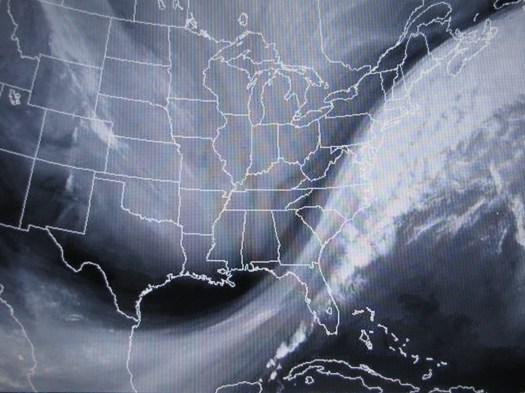
A storm battering the Midwest will impede our progress back north to Charleston and threatens to bring us the only foul weather of the cruise. Note the location of the cold front over the Florida Straits.

“Now the great winds shoreward blow;
Now the salt tides seaward flow;
Now the wild white horses play,
Champ and chafe and toss the spray.”
Matthew Arnold

As the sailors say: "The sheep are grazing." A gale is brewing and kicking up whitecaps as we sail north to Charleston.
As the sailors say: “The sheep are grazing.”
A gale is brewing and kicking up whitecaps as we sail north to Charleston.

Dave Grant: Terra Nova, February 13, 2012

NOAA Teacher at Sea
Dave Grant
Aboard NOAA Ship Ronald H. Brown
February 15 – March 5, 2012

Mission: Western Boundary Time Series
Geographical Area: Sub-Tropical Atlantic, off the Coast of the Bahamas
Date: February 13, 2012

Weather Data from the Bridge

Position: 26.30N Latitude – 71. 55W Longitude
Windspeed: 15 knots
Wind Direction: South (bearing 189 deg)
Air Temperature: 23.2 C / 74 F
Atm Pressure: 1013.9 mb
Water Depth: 17433 feet
Cloud Cover: 30%
Cloud Type: Cumulus

Personal Log

After an uneventful flight from New Jersey and an eventful trip from the airport at Charleston and through security at the naval base (Taxi drivers don’t like to have their vehicles inspected…), I am setting up my bunk on the Brown. There is a skeleton crew since I have arrived early and everyone else is expected to report tomorrow. Crates of equipment are still being loaded, so it is advisable to stay off the outside decks, and after a quick orientation by every  ship’s most important crew member (the chef),  I will have the evening free to find my way around the ship and explore the dock.
First order of business: Pick up bedding from the laundry down below.
Next: PB&J sandwich (Since the galley doesn’t open until tomorrow).
Finally: Grab the camera to catch the sunset and an amazing assortment of cloud types.

South Carolina’s estuaries are noted for their fine “muff” mud and oyster banks and the tideline at the docks is covered with a dense ring of oysters. Besides filtering great quantities of water and improving its quality, oyster “reefs” provide a secure habitat for a myriad of marinelife, and food for many creatures. (As a frustrated oyster farmer in South Jersey once remarked: “There ain’t much that lives in the ocean that doesn’t like to eat oysters!”)

Oyster Chain
Oyster Chain

Comorant
Comorant


Grebe
Grebe

The prettiest bird around is the red-breasted merganser, another diving fish eater. Hunters nicknamed mergansers “saw-bills” since their bills have tooth-like notches for snaring fishes. The word merganser comes via Latin mergere meaning “diver” and “to plunge.” Curiously, one of my favorite students always mixes up the word and somehow it comes out as Madagascar (!).

(Images on the Ron Brown by Dave Grant)

The most secretive and uncommon bird around the piers is the pied-billed grebe. It also dives for its dinner, but on the bottom. When frightened (or pestered by a photographer trying to get close in the fading light) it discreetly sinks straight down and disappears like a submarine. Locally, this trick earned the grebe the nickname water witch, and by Louisiana sportsmen Sac de plomb (bag-of-lead).

Grackle
Grackle

By far the noisiest birds around and the only ones onboard, are boat-tailed grackles. The iridescent, purple-black males are hard to ignore when gathering for the night on our upper rigging. A common bird of Southeastern marshes; since the 1960’s boat-tails have been expanding their range north along the Eastern seaboard beyond Delaware Bay, and now breed all along the New Jersey coast. (A normal extension of their population, or perhaps a response to warming climate? Time will tell.)

Just before dark a peregrine falcon surprised me as it glided past the ship – undeniably the most exciting sighting of the day and a great way to end it.

 “Oh end this day,
show
me the ocean.
When shall I see the sea.
May this day set me in emotion
I ought to be on my way”
(James Taylor)

Wes Struble: Arrival and Departure, February 19, 2012

NOAA Teacher at Sea
Wes Struble
Aboard NOAA Ship Ronald H. Brown
February 15 – March 5, 2012

Mission: Western Boundary Time Series
Geographical Area: Sub-Tropical Atlantic, off the Coast of the Bahamas
Date: February 19, 2012

Weather Data from the Bridge

Position: 26 deg 30 min MN Latitiude & 71 deg 55 min Longitude
Windspeed: 15 knots
Wind Direction: South (bearing 189 deg)
Air Temperature: 23.2 deg C / 74 deg F
Atm Pressure: 1013.9 mb
Water Depth: 17433 feet
Cloud Cover: 30%
Cloud Type: Cumulus

Personal Log

With some minor travel changes in Seattle and a redeye flight into Charleston, South Carolina I arrived at NOAA Ship Ronald H. Brown at about 10:30 am Tuesday morning – tired but grateful. We left port mid-morning the next day and headed south/southeast. On the way out of port we were treated to a dolphin escort – five or six dolphins surfed our bow wave for half an hour or more. I share a stateroom with another teacher, David Grant. My stateroom  is comfortable and I will be sleeping on the upper bunk – a somewhat tight fit and something I haven’t done since my brother and I were sharing a room while we were in junior high school.

The Ronald H. Brown docked at the pier before our departure

David Grant, my fellow teacher-at-sea, working in our stateroom
A Dolphin escort off the bow of the Ron Brown as we head out of Charleston

The Ron Brown is the largest ship in the NOAA fleet. She was commissioned in 1997 and is named in honor of Ronald H. Brown, Secretary of Commerce under the Clinton Administration who died in a plane crash on a trip to Bosnia. With a length of just under 280 feet the Ron Brown has ample deck space for hauling all the various amounts of materials and equipment needed for a research cruise.  The ship’s captain is Captain Mark Pickett, the Executive Officer is Lieutenant Commander Elizabeth Jones, the operations officer is Lieutenant James Brinkley, the medical officer is Lieutenant Christian Rathke, with Ensign Aaron Colohan, and Ensign Jesse Milton making up the remaining officers. The entire ship’s complement is divided up between the NOAA Corps crew members, the merchant marines, and the science staff. For this trip we have approximately 50 people on board including the crew and the scientists.  From the science group there are four of us that will be dividing up the CTD watch: David Grant, Shane Elipot, Aurélie Duchez, and myself. As I mentioned earlier, David Grant is my Teacher at Sea colleague for this cruise. He hails from Sandy Hook, New Jersey which is considered the most northern sandy beach in the state. David teaches a variety of science courses at a community college. Shane & Aurélie are from France (although they both currently work in the UK for the Natural Environment Research Council).

A Coast Guard Ship shared the pier with the Ron Brown
The Arthur Ravenel Jr. Bridge over the Cooper River, Charleston SC - a fine example of a graceful Cable Stay Bridge
A view of the Arthur Ravenel Jr. Bridge from below as the Ron Brown passes under the bridge
A view of Fort Sumter - one of the icons of the War between the States
A mass of sargassum (floating seaweed) - from which we derive the name of this part of the Atlantic Ocean - the Sargasso Sea

After the Brown got underway we had the first of many drills. All of the science crew met in the main lab where one of the NOAA Corps officers, ENS Jesse Milton, reviewed the proper use of the rescue breathing apparatus, the Gumby suit, and the PFD (personal flotation device). When the meeting was over we had three practice drills: Fire/Emergency, Abandon ship, and Man Overboard. Each of these emergency situations has their own alarm bell pattern and all those aboard have particular responsibilities and particular muster stations to which they are to report.

A Fire/Emergency is identified by a long (10 seconds or more) continuous alarm bell. When the bell sounds everyone is to move to their assigned stations. The science crew is to go to the main lab and await instructions. If the main lab is actually where the fire or emergency is located our second muster point is the mess.

A series of short blasts (at least 6) followed by a long continuous blast indicates Abandon ship. When this alarm sounds you are to drop whatever you are doing return to your stateroom and retrieve your PFD and Gumby suit and report to your muster station. In addition to the life saving articles, you should be wearing long pants, a long sleeve shirt, and a hat (to protect you from exposure while drifting at sea in the life boat). For this emergency situation I am to report to fire station 15 with a number of other members of the crew and be ready to load into a lifeboat.

Three long alarm bells announce a man overboard. During this emergency different groups of people are assigned different positions around the ship to look for and point to the person who has gone overboard. When the floating person is spotted, all those on deck are to indicate the overboard person’s position by pointing with their outstretched arm. A person floating in the water produces a very low profile and can be very difficult to see from a small boat bouncing in the waves. If the rescue team has trouble locating the floating person they can look up at the ship and see where all the spotters are pointing. This can direct them toward the overboard person’s location.

Elizabeth Bullock: Day 5, December 15, 2011

NOAA Teacher at Sea
Elizabeth Bullock
Aboard R/V Walton Smith
December 11-15, 2011

Mission: South Florida Bimonthly Regional Survey
Geographical Area: South Florida Coast and Gulf of Mexico
Date: December 15, 2011

Weather Data from the Bridge
Time: 3:15pm
Air Temperature: 23.6 degrees C
Wind Speed: 15.8 knots
Relative Humidity: 56%

Science and Technology Log

Liz takes a water sample
Here I am taking a water sample from the CTD.

Let’s talk about the flurometer!  The flurometer is  a piece of equipment attached to the CTD which is being used on this cruise to measure the amount of chlorophyll (specifically chlorophyll_a) in the water being sampled.  It works by emitting different wavelengths of light into a water sample.  The phytoplankton in the sample absorb some of this light and reemit some of it.  The flurometer measures the fluorescence (or light that is emitted by the phytoplankton) and the computer attached to the CTD records the voltage of the fluorescence.

The flurometer can be used to measure other characteristics of water, but for this research cruise, we are measuring chlorophyll.  As you know, chlorophyll is an indicator of how much phytoplankton is in the water.  Phytoplankton makes up the base of the marine food web and it is an important indicator of the health of the surrounding ecosystem.

At the same time that our cruise is collecting this information, satellites are also examining these components of water quality.  The measurements taken by the scientific party can be compared to the measurements being taken by the satellite.  By making this comparison, the scientists can check their work.  They can also calibrate the satellite, constantly improving the data they receive.

Combined with all the other research I’ve written about in previous blogs, the scientists can make a comprehensive picture of the ecosystem with the flurometer.  They can ask: Is the water quality improving?  Degrading?  Are the organisms that live in this area thriving?  Suffering?

Nelson records data from the CTD
Nelson records data from the CTD.

Collecting data can help us make decisions about how better to protect our environment.  For example, this particular scientific party, led by Nelson Melo, was able to inform the government of Florida to allow more freshwater to flow into Florida Bay.  Nelson and his team observed extremely high salinity in Florida Bay, and they used the data they collected to inform policy makers.

Personal Log

Today is my last full day on the Walton Smith.  The week went by so fast!  I had an amazing time and I want to say thank you to the crew and scientific party on board.  They welcomed me and taught me so much in such a short time!

Thank you also to everyone who read my blog.  I hope you enjoyed catching a glimpse of science in action!

Answers to Poll Questions:

1)      In order to apply to the Teacher at Sea program, you must be currently employed, full-time, and employed in the same or similar capacity next year as

a. a K-12 teacher or administrator

b. a community college, college, or university teacher

c. a museum or aquarium educator

d. an adult education teacher

2)      The R/V Walton Smith holds 10,000 gallons of fuel.  By the way, the ship also holds 3,000 gallons of water (although the ship desalinates an additional 20-40 gallons of water an hour).

Elizabeth Bullock: Day 3, December 13, 2011

NOAA Teacher at Sea
Elizabeth Bullock
Aboard R/V Walton Smith
December 11-15, 2011

Mission: South Florida Bimonthly Regional Survey
Geographical Area: South Florida Coast and Gulf of Mexico
Date: December 13, 2011

Weather Data from the Bridge
Time: 4:45pm
Air Temperature: 23.5 degrees C
Wind Speed: 15 kt
Relative Humidity: 68%

Science and Technology Log

Liz deploys a drifter
I'm deploying a drifter!

Last night, we deployed our first drifter.  There will be three deployed over the course of this cruise.  The frame of this drifter is built by the scientists at AOML (Atlantic Oceanographic and Meteorological Laboratory).  Afterwards, they attach a satellite transmitter so they can track where the drifter goes.  This helps them measure the surface currents.

What are some other types of research being conducted onboard?  I’m glad you asked!  Two NOAA researchers, Lindsey and Rachel, are studying water chemistry and chlorophyll.  They take samples of surface water from the CTD to study CO2 and the full carbonate profile.  They also use water collected at many different depths to study the chlorophyll content.  Chlorophyll is an indicator of the amount of phytoplankton in the water.

Collecting water from the CTD
Collecting water from the CTD.

Sharein, a PhD student at the University of Miami Rosenstiel School of Marine and Atmospheric Science, is studying a specific type of plankton called copepods.

The particular copepod that she is studying is food for the larval stages of some commercially important species of fish such as bill fish (which include blue marlin, sail fish, white tuna, and yellowfin tuna) and different species of reef fish.  If a species is commercially important, it means that many people depend on this particular fish for their livelihoods.

Female Copepod
Here is one of the species of copepods that Sharein is studying.

Do you think you would be interested in working at sea?  You would be a good candidate if you:

1)      Like meeting new people and working as part of a team

2)      Are interested in the ocean, weather, and/or atmosphere

3)      Don’t mind getting your feet wet

Personal Log

When we were on our way to the Tortugas, we didn’t have cell service and the TV in the galley had no signal.  It was nice to be disconnected for a while.  Although there are still 29 computers onboard which all have the internet, so we’re hardly off the grid!

It was hard at first to adjust to the night shift, but everyone onboard was really supportive.  Working the night shift means that you work from 7pm to 7am.

Species seen last night in the Neuston net:

Flying fish

Needle fish

Different kinds of sea grasses and sargassum

Moon jellies