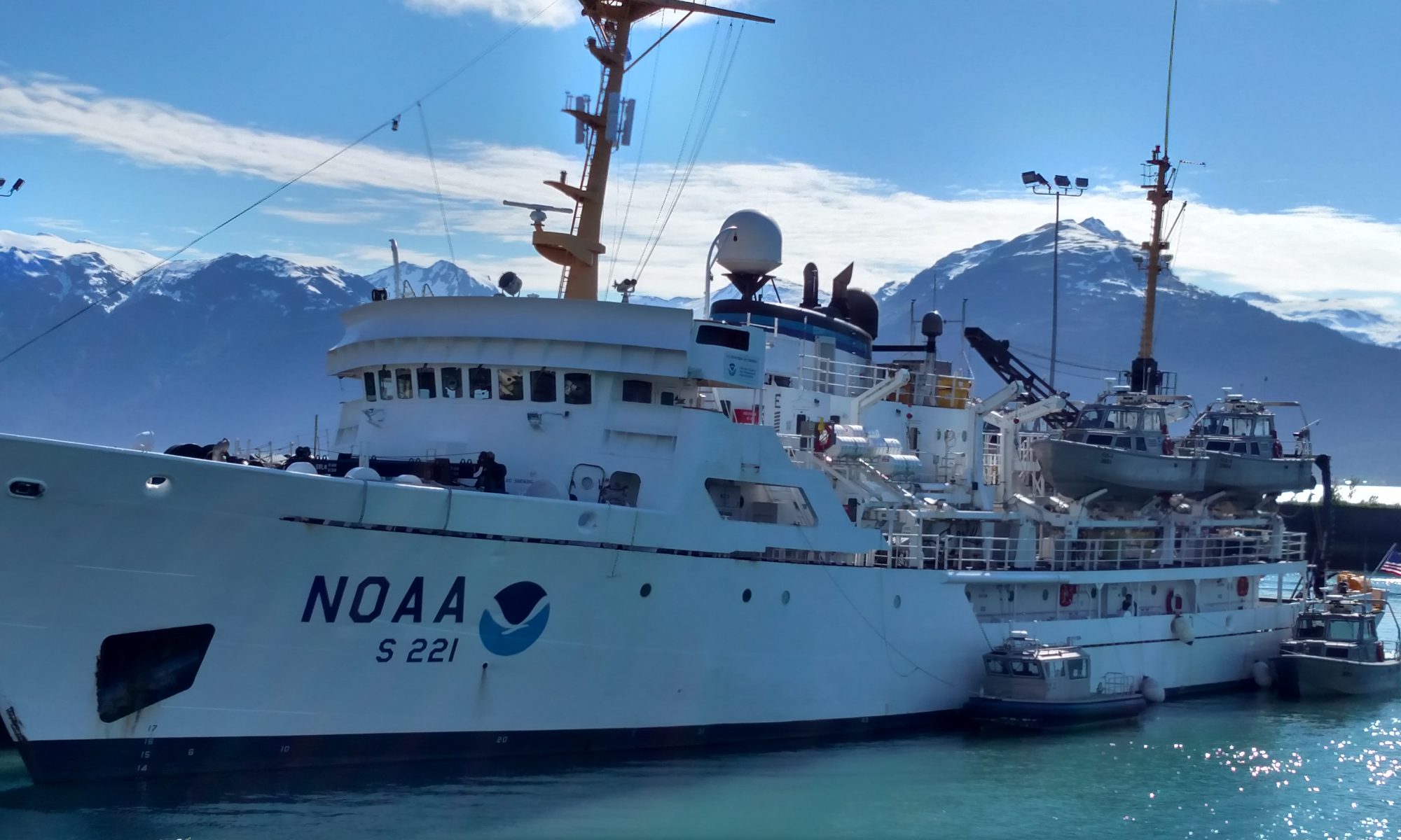
Eric Koser: Let the Science Begin! June 27, 2018

NOAA Teacher at Sea
Eric Koser
Aboard Ship Rainier
June 22-July 9
Mission: Lisianski Strait Survey, AK
June 27, 2018: 1500 HRS

Weather Data From the Bridge
Lat: 57°52.9’          Long: 133°33.8’
Skies: Overcast
Wind 15 kts at 011°
Visibility 10+ miles
Seas: Calm
Water temp: 3.9°C

Science and Technology Log

Rainier Hat
This insignia cap is worn by the NOAA Corps members on the ship.

Let the science begin! We departed from Sitka about 1300 on Monday enroute for Lisianski Inlet. Getting out to sea has been a wonderful experience. Ship Rainier is truly run by a dedicated team of people. I have been able to spend quite a bit of time on the bridge – first watching and then participating with the Junior Officers on the deck. It quickly became obvious to me that this is a teaching operation. The hands on the deck represent a variety of experience levels, quite by design. More experienced NOAA Corps Officers coach Junior Officers through each procedure that happens on the Bridge. It’s a great example of a team based ‘on the job’ teaching system!

On the bridge there is always an OOD (Officer On the Deck) that is in charge of operations. This person then helps to administrate the work of the CONN (responsible for the conduct of the vessel), the helm, the lee helm, the lookouts, and the navigator. The CONN gives commands to the others on the team, which are then repeated back to assure clarity.

Chart Table
This is the chart table where the Navigator works on the bridge of the ship.

The first task I learned was to plot our course on the charts. The CO (Commanding Officer—in charge of the entire ship) selects waypoints for an upcoming course in a digital mapping suite called Coastal.   Coastal sets a series of digital paths that each include a compass bearing (direction in degrees) and range (distance in nautical miles) between each waypoint. Then the navigator takes this same series of points and plots them by hand in pencil on the series of chart {the nautical term for maps]. Each point is a pair of latitude and longitude points plotted as a small square. Given the expected cruising speed, the navigator can also estimate future positions of the ship, which are referred to as “dead reckoning” and are plotted with a half circle.


Sheet Route
A route that I plotted on our charts.
Coastal
A view from the Coastal software of a route.

Periodically the navigator measures the location of the ship either digitally with GPS or by measuring distances to adjacent land features with radar. A pair of dividers is used to plot these distances on the sheet as small triangles and confirm the current location of the ship. By these methods, the navigator assures the ship is on the planned track and/or adjusts the track accordingly.

The person at the helm (the steering wheel) is directed by the CONN to point the ship at the necessary bearing. As changes are needed to the bearing, the person at the helm responds to the CONN’s commands to adjust.

In Lisianski Inlet the team of hydrographers started collecting data with the multibeam sonar system around midnight Tuesday morning. As we traveled along the entire length of the Inlet overnight, this initial data was collected. When we arrived at the small town of Pelican, AK (pop. 88) a crew on a launch (small boat deployed from Rainier) traveled in and set up a HORCON (Horizontal Control) reference station. This is a high precision satellite receiver. It provides a very accurate way to measure potential drift in satellite indicated GPS over time. After taking data from the ship, the latitude and longitude are corrected with data from the HORCON.

Launch RA
This is one of several small(er) boats called “Launches” that are used for surveying.
Ship Rainier
This is a view of our ship from the launch.

After this initial work was complete at Lisianski, we began transit to Tracy Arm Fjord. While the multibeam sonar work was completed here last week, three crews deployed in launches to ‘proof’ the shoreline information on the charts. This is essentially confirming and updating the existence and location of particular features (rocks, ledges, etc).

Tracy Arm
This was the view as we approached the glacier at the end of Tracy Arm.
Launch Team
NOAA Hydrographer Amanda Finn and I together on the launch.

At this point, the hydrographers are processing much of the data obtained in the past few days. Additional data will be collected tomorrow morning. Then in the evening we’ll transit back to Lisianski to begin further work there.

Ship among ice.
The ship parked here while the launches moved closer to the ice.
Glacial Ice
The glacial ice shows a beautiful blue color.
Ice Blue
Different pieces of ice appear slightly different colors.

Personal Log

Every member of the team on this vessel has a job to do. Every member matters. The success of the entire operations depends upon the teamwork of all. There is a positive sprit among the group to work together for the tasks at hand.

I’ve been welcomed to learn to chart our course. I had an opportunity today to operate the helm (steering). I went out on a launch today to visit waters that were yet uncharted as the glacier at the end of Tracy Arm Fjord is receding. It was incredible to see not only the beauty of the ice among the water, but to also witness from afar the calving of the glacier. A rumble like thunder accompanied the crashing of two small walls of ice into the ocean below as we watched from afar.

I enjoyed capturing many photos of the ice and the wildlife among it. Many harbor seals were relaxing upon chunks of glacial ice as we traveled through the Arm. The natural beauty of this area is best represented by a few photos.

An adult seal and pup
This adult seal was watching us closely with the pup.
Ice Dog?
What can you see in this ice? Might it resemble a dog?

Did You Know?

Junior Officers in the NOAA Corps learn in a 19 week program followed by 2 weeks at sea on a tall ship called Eagle.

There are approximately 320 commissioned officers in the NOAA Corps internationally.

NOAA Operates 16 Ships and 20 Aircraft!

Cindy Byers: On the Homefront, May 19, 2018

NOAA Teacher at Sea
Cindy Byers
Aboard NOAA Ship Fairweather
April 29 – May 13, 2018

Mission: Southeast Alaska Hydrographic Survey

Geographic Area of Cruise: Southeast Alaska

Date: May 19, 2018

Weather:  It is SPRING in Wisconsin!


Personal Log

I got home this week from an absolutely amazing experience on NOAA Ship Fairweather!  I arrived so excited to share what I have learned with students and other teachers alike!  I went to school 30 minutes before the end of the day bell when I arrived.  I felt like I was welcomed back like a hero!  My students and the staff were happy to see me, and I was very happy to see them!  I got lots of hugs and high fives.  It was especially exciting to hear that the students had enjoyed and learned from my blog.  They especially liked to learn what I had eaten!

I was able to share some pictures and stories this week as our year winds down. I have begun organizing my photos and have plans with the staff to give a presentations to all the 4-8 grade students in the fall.  Ideas are flowing through me about how I will incorporate my new knowledge and experiences into my different curriculums.  There is so much potential!

I have not stopped talking about my experience with people in and out of school.  I love having so many experiences to share.  The people of NOAA Ship Fairweather where so willing to teach me about hydrography and ship life.  I have strong memories of people asking if I wanted to try doing something, or calling me over to explain something they were doing.  I, of course, hopped in and tried everything I could!  I got to drive the ship on my first morning!  I also was able to drive the launches! (Thanks Colin!)  I learned so much about being a hydrographer thanks to all the surveyors!   What a wonderful group of people.  I could thank everyone really, the deck crew, the engineers, the stewards, the NOAA Corps officers, and the great leadership of the XO and CO.  I was able to learn from all of them.  Everyone always made me feel like they had time to teach me how to do things, and to answer questions.  It is exciting to be in a place with so many talented educators!

This is a trip that will influence how I approach my teaching and my everyday life.  I will never forget the kindness and caring of NOAA Ship Fairweather personnel, or the beauty and splendor of SE Alaska!

NOAA Corps mustaches
NOAA Corps Officers! Mustaches are required.
CTD Cast
Taking a CTD Cast
IMG_8844
Setting up a HorCon (Horizontal Control) Station
Dawes Glacier
Our NOAA Physical Scientist at Dawes Glacier
Bald eagle skull
A Bald Eagle skull being examined
Skiff ride
Skiff ride to a shore party
Settlers of Catan
A game of Settlers of Catan
Sam in galley
Sam, one of the stewards, in the galley
Hydrographer
Ali Johnson, Hydrographer, at work
Bekah with guide
Hydrographer Bekah Gossett looking up marine mammals
LTJG Douglas
NOAA Corps Officer LTJG Douglas on the bow
Life on the Bridge
Life on the Bridge
Kayaking
Kayaking
Glacial moraine
Me and the mountains from the glacial moraine

Cindy Byers: Working at Sea, May 9, 2018

NOAA Teacher at Sea
Cindy Byers
Aboard NOAA Ship Fairweather
April 29 – May 13

Mission: Southeast Alaska Hydrographic Survey

Geographic Area of Cruise: Southeast Alaska

Date: May 9, 2018

Weather from the Bridge

Latitude: 57° 43.2 N
Longitude:133° 35.6
Sea Wave Height: 0
Wind Speed: 3 knots
Wind Direction: Variable
Visibility:10 Nautical miles
Air Temperature: 15° C
Sky: 90% cloud cover

Me on boat in Endicott Fjord, Dawes Glacier
Dawes Glacier In Endicott Fjord

Science and Technology Log

When I reflect on the personalities of the people living and working on NOAA Ship Fairweather, two words come to mind: challenge and adventure.  They are also people that are self-confident, friendly, they see great purpose, and take great pride in their work.  Life is not always easy on board a ship. People are often very far from family and away from many of the comforts of home.  But for this group, it seems that they are willing to give up those hardships for being at sea. Below are some interviews I did with personnel on the ship.

Terry – Deck Crew

Terry is part of what is called the deck crew.  He reported to me that his duties include standing bridge watch, which means looking out from the bridge to warn the bridge crew of any obstacles or dangers ahead of them. On this trip those hazards have been fishing vessels, and gear, and whales.  He also will be at the helm, which means steering the ship as directed by a bridge officer. Other bridge duties include monitoring the radio and radar when the ship is anchored. He said that like everyone on the bridge, he needs to be aware of where the ship is at all times. He is part of the Deck Department so he does maintenance such as keeping things greased, painted and clean.  The deck department also keeps the ships interior clean, except for the galley and the mess

IMG_9071 Terry
Terry at the Helm

What got you interested in the sea?
When I was eight, I moved from Michigan to Florida and I fell in love with the sea.  I used to run up and down the beach.

I liked Jimmy Buffett, “A Pirate Turns Forty,” and I liked reading adventure books by Jack London.  When I was 13, I also read Moby Dick and The Odyssey.  I read The Odyssey every year, I love that book.  I really like the lore of the sea and the freedom of being at sea. I like the idea of going to exotic places.

When were you first in a boat in the ocean?
When I was 10 years old I went on a day cruise from Tampa, Florida. It was a dive boat that was used to take tourists out. I loved it, if I could get on a boat, I would go. I tried to build a skiff, but it took on water.

When did you first work on the ocean?
I went to sea when I was 24 years old.  In my first job I worked bringing supplies to oil rigs. I found an ad for the job and they said no experience was needed. I wanted to be a captain, I wanted to travel and see the world.  I watched a lot of Indiana Jones. I wanted to be an adventurer. When oil prices went down I was out of a job, but in 2000 I worked for another oil company.

What other jobs have you had?
After 9/11, I joined the Military Sealift Command, which is a civilian part of the Navy. They bring food, fuel, and supplies to Navy ships [he was in the Mediterranean Sea.] Military ships do not fuel in ports where they could get attacked.

In 2013 I had a wife and two kids and so I did different jobs, not at sea.

When did you first start to work for NOAA?  
In 2016 I was hired by NOAA on NOAA Ship Fairweather. This boat and NOAA Ship Rainier are where people start.  I started as an Ordinary Seaman. Now I am Able Seaman.  To move up I needed to take a course in survival training and fire training. I did this in Louisiana at a community college, it took two weeks.  I also needed six months of experience on a NOAA vessel.

IMG_9073
Terry at the helm

What is your favorite part of the job?
I like being at the helm and steering the ship. I like going to different places and seeing different things. I like that the ship has extra functions to keep up moral up. I even did a comedy show twice. It is like your own community. It is great being part of a team and accomplishing a goal.

What is the hardest part of the job?
The hardest thing is being away from home.  For every 9 months away, I am home for a few months, that is spread out over a year.  The season is 7-8 months.

What do you think it takes to be on a ship away from your family?
Everyone has to be a team player.  You need to really get along with others.  People need to be confident and you need to show respect to each other.  You live in very tight quarters. Nobody has a job that is small, everybody’s job needs to be done.


Jeff – NOAA Corps Junior Officer


I grew up in Juno, Alaska and went to college there.  I got a Bachelor’s degree in math, I never thought I would be interested in math.  I started out with an art major then went to geology, then biology, then math. I liked that I learned a new set of rules during the day and then got to apply them to problems that I could solve.  It took me six years to get my degree. I paid for it myself by working and I was living in a sailboat in the harbor.

Jeff
Jeff in the launch during bottom sampling

What brought you to a career in NOAA?
Previously I was a Sergeant in the Army for five years.  I was searching for tide information for a fishing trip and was on a NOAA website,  There I saw a recruiting video and decided to do that. It took a couple years to get into the NOAA Corps. I was first hired on a NOAA Ship Oscar Dyson as a General Vessel Assistant in the deck department. Then I found out I was accepted into the NOAA Corps.  After my Officer Training in New London, Connecticut I was assigned to NOAA Ship Fairweather.

What is your role on the ship?
I am a Junior Officer.  I am here to learn how to drive ships and learn the science of hydrography.  I am learning how to become a professional mariner.

What are the best parts of your job?
Ever since the Army I enjoyed being part of a team. On the ship there is a lot of social interaction.  It is a tight community of people that live and work together. We have all types of personalities.

I really like going out on a launch (the small boats used for surveying) and collecting data. We are in beautiful places and we get to eat our picnic lunches and listen to music and work together to figure out how to drive our lines and to collect the data we need.

I also like processing and organizing the data we get.  Our project areas are divided up into acquisition areas and I work as a Sheet Manager for an area. So, I am responsible for taking the data that is cleaned up from the night processors (who clean up the data when it first comes in) and getting a map ready for the launches with areas that need more data collection and safety hazards marked. I keep track of what needs to be done and report those needs to my superiors.

What do you like to do on the ship when you aren’t working?
I like the VersaClimber.  (This is in the gym. There is a ship contest going on to see who can climb highest!)  I used to do some fishing. I also spend time communicating with my family.

What do you miss when you are at sea?
Mostly I miss my family.  I also miss doing things like going for a walk to get coffee.  Since the field season is all summer, I really miss going camping with my family.

What will you be doing for your next assignment with NOAA?
Assignments are two years on a ship and three years on land.  Next, NOAA is sending me to graduate school for three years. So I will be working on a  Master’s Degree in Ocean Engineering with an emphasis in Ocean Mapping.


Niko – Chief Engineer

I had a conversation with Niko one day because I was really interested in how the water on the ship was acquired and disposed of.  I learned that and a little more!

I asked Niko what got him interested in being at sea.  He told me that this family had a cabin on an island in the state of Washington. He loved driving the families small boat whenever he could.  He would take it out for 8 hours a day. In Middle School and High School he did small engine repair. He took a lot of shop classes and was in a program called “First Robotics.” He thought he wanted to be a welder. His mom worked for the  BP oil company and through that he learned about maritime school. He went to school at Cal Maritime, (The California State University Maritime Academy.)  There he studied Marine Engineering Technology. He said it was hard.  Of the 75 students that started in his class, only 14 graduated on time.

IMG_8723
Niko in his office

He told me that NOAA Ship Fairweather has engines from 1968, and they are due for a rebuild,  They have 20,000 hours since the last rebuild in 2004, that is like running them 3 straight years..  

Niko is the Chief Engineer.  He has a department of nine engineers.

I asked him about the freshwater on the ship. He said the ship uses 600 gallons a day without the laundry and 2000 gallons a day if the laundry is in use.  It takes 17,000 gallons of water to go for 10 days. The ship has freshwater tanks that are filled when they are in port, but the ship can produce freshwater from salt water.  To do this the ship must be moving. It uses a method which evaporates the salt water so the freshwater is left behind. This costs one gallon of diesel to produce 9.7 gallons of freshwater.  This costs is $0.30 a gallon for water. The sinks, showers, dishwasher and laundry all use freshwater. The toilets use saltwater.

Personal Log

I have learned an amazing amount about ocean mapping from my time on NOAA Ship Fairweather.  I have also learned a lot about different NOAA careers and life on a ship. But like any good experience, it is always the people that make things great!

I have really enjoyed getting to meet all of the people of the ship.  They have been so kind to take me in and show me their jobs and let me try out new things, like driving a ship and a launch!

We have also had fun kayaking, watching wildlife, and taking a walk on shore.

eagle on ice
Eagle on Ice
IMG_8668
Life Jackets and Float Coats
IMG_8767
Kayaks on board
Bear
Here is a Brown Bear that was along the shoreline today
IMG_9047
Launches leaving for a day of surveying
Launch
A Launch

Lisa Battig: DRs, The Survey Team and A Goodbye in Kodiak, September 8, 2017

NOAA Teacher At Sea

Lisa Battig

Aboard NOAA Ship Fairweather

August 28 – September 8, 2017


Mission: Alaskan Hydrographic Survey

Geographic Location: Kodiak and Anchorage Airports and back home

Date: September 8, 2017


map of route to kodiak
A map of the long transit south from the through the Aleutians and then northeast to Kodiak (the dark green line was the Tuesday evening through Friday morning transit from the Yukon River delta)

The last three and a half days of the experience were the transit back to Kodiak. This gave me a lot of time up on the bridge and in the surveyors’ work areas.

So many things impressed me about the crew on this trip.  I think most of all, seeing that a group of young scientists between 22 and 38 (I believe) were ultimately responsible for all of the ship operations and were doing a phenomenal job! Fairweather has the largest number of junior officers on board and the atmosphere is of constant training. I kept thinking about the ages of most of the junior officers and how my own students could be in this position in a few years. The opportunity to grow as a member of a uniformed service and receive all of the training while still being able to pursue the sciences is incredible to me and I intend to make sure that my students know about the opportunity. I can’t tell you how many times I thought, “If I had just known this existed when I graduated college…”


On the long trip back, we were traveling through dense fog, narrow rocky passes in the middle of the night, and areas of high and sometimes unpredictable currents. We even managed a rendezvous with another NOAA vessel in order to pass of some medical supplies. Throughout all of it, I watched the NOAA Commissioned Corps officers handle everything with tremendous grace under pressure. But on Fairweather, I found out their work does not stop with the ship operations. Each of the officers are also directly involved with the hydrographic science, and have responsibility for a specific survey area.

The Survey team are also responsible for specific survey areas.

Drew & Bekah
Survey techs Bekah and Drew at their computers. If they’re not eating, sleeping, working out, or on a survey boat – this is probably what they’re doing!

For each area owner, this culminates in a final report (called a Division Report, or DR) giving details of the survey and talking through all anomalies. Survey work does not stop. These folks are working 7 days a week and often 14+ hour days when they are out at sea.

In some cases the owner of a survey area will have very intimate knowledge of a survey area because they had the opportunity to be out on the survey boats. But in many cases, this will not be true. Ultimately their responsibility is making absolutely certain that every piece of necessary information has been gathered and that the data is clean. I was told that in most cases, writing the final report will take a couple months.

These reports will eventually become mapped data that is accessible to anyone through the National Centers for Environmental Information (NCEI). But it will also be sent in various forms to be housed for shipping navigation and other industries.

Sleepy Surveyors
If you’re working long hours 7 days a week, you learn to take advantage of any opportunity you get to rest. A couple members of the survey team, catching a nap on the transit back from the Yukon Delta to Fairweather.

With all of the work they do at sea, ports can become very welcome places. The Fairweather crew had gone into port at Nome, Alaska several time through July and August and were excited to pull into Kodiak. Even on our transit south, I watched the crew get more excited as they left the desolation of the tundra and we began to see cliffs and trees again.

I am so glad that I saw the tundra finally, and that I will now be able to explain it more fully to my students, but I can also completely understand how the sheer vastness of the northern parts of Alaska could make you long for more varied terrain.

Kodiak harbor
Harbors in Southern California don’t look like this!! Coast Guard Base harbor in Kodiak, AK

I only got to spend one day in Kodiak, but it is a breathtaking place. I didn’t get to do any serious hiking, but I did see the salmon running and ended up on an old nature trail. And the best part was that I got to see a bunch of amazing people relax and enjoy their time away from work.

Would I do this again if I had the opportunity? Unequivocally YES!! I would jump at the chance!

Would I recommend this to other teachers? Absolutely! It is an amazing experience. Granted, I think I had the best ship with the best crew…


Jenny Hartigan: Organisms from the Deep! July 27, 2017

NOAA Teacher at Sea

Jenny Hartigan

Aboard NOAA Ship R/V Fulmar

July 27, 2017

Mission: Applied California Current Ecosystem Studies: Bird, mammal, plankton, and water column survey

Geographic Area: North-central California

Date: July 27, 2017

Weather Data from the Bridge:

Latitude: 38º 19.820’ N

Longitude: 123º 03.402’ W

Time: 0700 hours

Sky: overcast

Visibility: 8 nautical miles

Wind Direction: NW

Wind Speed: 15-25 knots

Sea Wave Height: 3-5’

NW Swell 5-7 feet at 8 seconds

Barometric pressure: 1028 hPA

Air temperature: 63º F

Wind Chill: 51º F

Rainfall: 0 mm


Scientific Log:

As I described in another blog, the ACCESS cruise records data about top-level predators, plankton, and environmental conditions as indicators of ecosystem health. Today I’ll explain sampling of plankton and environmental conditions.


IMG_7858
Krill from the Tucker Trawl Photo credit: J. Jahncke/ NOAA/Point Blue/ACCESS


IMG_8048
a single krill. Photo credit: J. Jahncke/NOAA/Point Blue/ACCESS


a small squid – Video credit: J. Jahncke/NOAA/Point Blue/ACCESS


There are two methods of collecting plankton. The Tucker Trawl, a large net with 3 levels is used to sample organisms that live in deep water (200 meters or more) just beyond the continental shelf. The collected krill and plankton are sent to a lab for identification and counting.

IMG_7993
Scientist Dani Lipski (left) and myself with the hoop net. Photo credit: C.Fish/NOAA/Point Blue/ACCESS


Another method of sampling producers and organisms is the hoop net, deployed to within 50 meters of the surface.


2017-07-27 09.15.22
Here I am with my daily job of cleaning the CTD. I also prepare labels for the samples, assist with the CTD, Niskin and hoop net, and Tucker Trawl if needed. Photo credit: C. Fish/NOAA/Point Blue/ACCESS


Deploying the CTD and hoop net – Video credit: J. Jahncke/NOAA/Point Blue/ACCESS

Environmental conditions are sampled using the Conductivity, Temperature and Depth (CTD) device. It measures conductivity (salinity) of the water, temperature and depth. The CTD is deployed multiple times along one transect line. Nutrients and phytoplankton are also sampled using a net at the surface of the water. I interviewed several scientists and crew who help make this happen.

An Interview with a Scientist:

Danielle Lipski, Research Coordinator, Cordell Bank National Marine Sanctuary

IMG_7985 2
Dani and myself deploying the CTD Photo credit: C. Fish/NOAA/Point Blue/ACCESS


Why is your work important?

The many aspects of the ocean we sample give a good picture of ecosystem health. It affects our management of National Marine Sanctuaries in events such as ship strikes, harmful algal blooms and ocean acidification.

What do you enjoy the most about your work?

I like the variety of the work. I get to collaborate with other scientists, and see the whole project from start to finish.

Where do you do most of your work?

I spend 4 – 5 weeks at sea each year. The rest of the time I’m in the Cordell Bank National Marine Sanctuary office.

When did you know you wanted to pursue a career in science or an ocean career?

In high school I was fascinated with understanding why biological things are the way they are in the world. There are some amazing life forms and adaptations.

How did you become interested in communicating about science?

I want to make a difference in the world by applying science.

What’s at the top of your recommended reading list for a young person exploring ocean or science career options?

Silent Spring by Rachel Carson


An Interview with a Scientist:

Jaime Jahncke, Ph.D., California Current Director, Point Blue Conservation Science

FullSizeRender
Jaime checks the echo sounder for the location of krill. Photo credit: NOAA/Point Blue/ACCESS


Why is your work important?

We protect wildlife and ecosystems through science and outreach partnerships.

What do you enjoy the most about your work?

-being outside in nature and working with people who appreciate what I do.

When did you know you wanted to pursue a career in science or an ocean Science? 

I always wanted a career in marine science.

What part of your job did you least expect to be doing?

I thought whale study would not be a possibility, and I love whale study. (I started my career studying dolphin carcasses!)

What’s at the top of your recommended reading list for a young person exploring ocean or science career options?

The Story of the Essex – the history behind Moby Dick

An Interview with a NOAA Corpsman:

Brian Yannutz, Ensign, NOAA Corps


2017-07-26 13.40.44
Brian on the bridge Photo credit: J. Hartigan/NOAA/Point Blue/ACCESS


2017-07-26 13.19.44 2
Brian retrieving party balloons from the ocean so they won’t harm wildlife. Photo credit: J. Hartigan/NOAA/Point Blue/ACCESS

The NOAA Commissioned Officer Corps (NOAA Corps) is a uniformed service of the United States which provides professionals trained in sciences and engineering. Brian has been working for the NOAA Corps for 3 years. He is responsible for the ship while on watch, and other duties such as safety officer.


Why is your work important?

Among other duties, I drive the ship and operate the winch to deploy the trawl and CTD.

What do you enjoy the most about your work?

I enjoy meeting new people.

Where do you do most of your work?

I’m based out of Monterey, and spend 60 – 90 days per year at sea. I spend 40 hours / week maintaining the boat.

What tool do you use in your work that you could not live without?

-the Vessel Inventory Management System, which is a maintenance program.

When did you know you wanted to pursue a career in science or an ocean career?

In the summer of eighth grade I went to visit relatives in Germany. It was my first time in the ocean. I also spent 15 days in the San Juan Islands.

What’s at the top of your recommended reading list for a young person exploring ocean or science career options?

-the movie “The Life Aquatic”


Let’s Talk about Safety:

Brian is responsible for safety aboard ship and it is a high priority. Before sailing I had to do an immersion suit drill where I put on a heavy neoprene suit in 3 minutes. When on deck everyone wears wear a Personal Flotation Device (PFD), which could be a “float coat” or a “work vest”. A “float coat” looks like a giant orange parka with flotation built in. A “work vest” is a life vest. If you are working on the back deck when the winch line is under tension, you must wear a hard hat. Most people wear waterproof pants and boots to stay dry when hosing down nets.


FullSizeRender 2 2
That’s me, wearing the “gumby” immersion suit! Photo credit: J. Jahncke/NOAA/Point Blue/ACCESS


Bird and Mammals Seen Today in the Bodega Bay Wetlands:

35 Egrets, 1 Great Blue Heron, 1 Snowy Egret, many Brandt’s Cormorants, many Western Gulls

Did you know?

A blue whale spout has the general shape of a fire hydrant, and a humpback whale spout looks more like a fan.

Personal Log:

I suppose you are wondering what I do in my free time. Between my tasks on board, eating, and blogging, I am pretty busy. Getting extra rest is a big deal, because it’s hard work just to keep your balance on a ship. Some evenings, I feel like I have been skiing all day long! I spend a lot of my time on the flying bridge watching wildlife through my binoculars, or chatting with the scientists and crew. It is fabulous to be out here on the ocean.

Highlight of Today:

Watching several Dall’s Porpoises surfing the wake in front of the bow!

Questions of the Day:

Why do porpoises swim in front of the boat?

Why do whales breach? (Breaching is a behavior that looks like jumping out of the ocean on their side.)


I love hearing from you. Keep those comments coming!