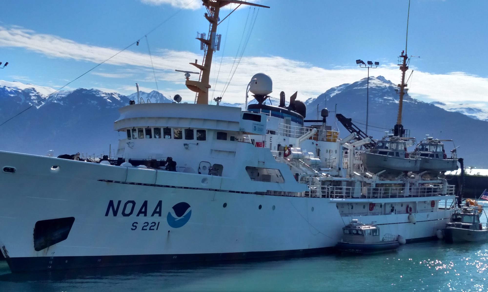
We cast off yesterday morning at 1000 hrs, RST—Rainier Ship Time. Although we are still in the Alaska Daylight Savings time zone, our time on the ship has been adjusted backwards 1 hour to give us more daylight during ‘working hours’. Since the ship is its own floating universe, time that is referenced to a specific time zone is not as important as time that is referenced to our day and the work that needs to be completed. Einstein would be pleased to see that time is, indeed, relative here aboard the Rainier!
There is science involved just to leave port and set forth on this cruise. There’s data to be collected, such as a weather forecast—and decisions to be made based on that data. Today’s weather report called for rain and high winds. That data input resulted in a travel plan including taking a more protected route north of Kodiak Island instead of heading out to more open water right away. We didn’t reach the wide-open spaces until evening, and I was lulled to sleep by the endless rocking and rolling of the boat.
We needed to take out the trash before we left.Heading into the Shelikof Strait
Science can also include the protocols needed to keep everyone on board safe and healthy during a cruise. With that in mind, I spent part of the day learning about the ship and the safety routines we need to follow. Ensign Wall gave me my survival suit, aka Gumby Suit and showed me how to don that lifesaving apparel. The suit is a foam-filled drysuit, providing insulation and floatation in one handy, non-form-fitting package. They are, apparently, one size fits none, but when it’s a matter of survival, I doubt that style counts for too many points!
Each person aboard is assigned stations to report to in case of fire or in case it becomes necessary to abandon ship. I found out that I go to the Boat Shop near the stern in case of fire, and that I head to Station 1 near the bridge. We had a fire drill in the afternoon, followed by an abandon ship drill. Much like fire drills at school, it’s a good time to practice and figure out the best way to get to where you need to go. Since I’m still learning my way around the ship, it was especially important to figure out where I needed to go and how to get there.
Where do I go?Trying on my Gumby suit
Then there’s the ‘real’ science—the science of hydrography and the point of this entire venture. The NOAA Ship Rainier has been tasked with charting (creating maps) of the Shumagin Islands and Cold Bay areas. It’s amazing to think that there are still some parts of our coastline that haven’t been charted. I spent much of this afternoon talking with the scientists who are making these maps and came away with the overwhelming sense that this is, indeed, a complicated and multi-faceted process. I’ll be writing separate journals on all the science that goes into creating these detailed maps of the ocean floor. If you just can’t wait and need to know more right now, check out the blogs from previous TAS teachers on the Ship Rainier.
Personal Log
Much of my first day at sea was spent getting used to being aboard a large floating object on a rather bumpy sea. Our day was spent in transit, from Kodiak to the Shumagin Islands, around 28 hours away.
My very first rainbow at sea!
There’s a lot to learn about life on board the Rainier. Most important has been orienting myself and figuring out where everything is located. Decks are labeled from ‘A’, the lowest, to ‘G’, the uppermost deck area. My quarters are on the ‘E’ deck. The Galley, where food is prepared and served, is on the ‘D’ deck below me, and the Bridge (steering and control of the ship) is above me on the ‘F’ deck.
I have my own room—kind of luxurious living! There’s a bunk, the head (bathroom), a couple of closets, drawers, and even a small fold-down desk area so that I can write my journals. Every drawer latches tightly to minimize the chance of unidentified flying objects if we hit some rough weather.
Home, sweet home.
I took a short tour of some of the more esoteric parts of the ship, including a visit to the cofferdam, whose access was through a hatch and down a ladder hidden in one of the heads (bathrooms). This is sort of like accessing the crawl space under your house through a small tunnel in your bathroom. While we speculated on just what purpose this area served (storage, poor planning in designing the hull and layout, a random skinny place to hang out?), it turns out that it is a watertight compartment that separates the contact between liquids that might be in the bow area and those in the stern area of the ship.
Starla Robinson leads us down the hatch into the cofferdamLt. Quintero in the cofferdam.
There was also an escape hatch that was incredibly heavy to lift—but I am sure you could lift it if your life depended on it! I don’t plan on having to test this thing out!!
NOAA Teacher at Sea Britta Culbertson Aboard NOAA Ship Oscar Dyson September 4-19, 2013
Mission: Juvenile Walley Pollock and Forage Fish Survey Geographical Area of Cruise: Gulf of Alaska Date: Tuesday, September 3rd, 2013
Weather Data from the Bridge (for Sept 4th at 8:57 PM UTC):
Wind Speed: 5.11 kts
Air Temperature: 12.6 degrees C
Relative Humidity: 70%
Barometric Pressure: 1003.2 mb
Latitude: 57.78 N Longitude: 152.43 W
Personal Log
Oscar Dyson in Port – Kodiak, AK
My trip to Kodiak from Washington, DC was a long one. I left DC early in the morning on September 2nd and I nearly missed my connection in Seattle after our flight left late from Reagan National Airport. I tried to dash off the plane, lugging my suitcase and backpack, with only 10 minutes to get to my connecting flight before it was supposed to take off. Fortunately, I know my way around SEA-TAC airport and with all of my escalator running experience from a year of DC living, I was able to get to my gate with 2 minutes to spare. On the plane, I was reunited with the scientists for my cruise and off we flew to Anchorage. Three and a half hours later, we arrived in Anchorage and from there it was just a one-hour flight to Kodiak Island where the NOAA ship the Oscar Dyson was in port.
While the ship was in port, we slept on board and I got used to the subtle rolls of the ship, which of course is nothing like when the ship is in motion. After a long day of travel on Monday, we ate dinner in town and went straight to bed afterwards. I spent the first day on the ship getting acquainted with the twists and turns of the hallways and the multiple staircases leading to different parts of the ship. Interestingly, you can’t walk from bow to aft on the same level on the Dyson, which makes it kind of difficult to get a nice deck side stroll.
There are 8 people, including myself, on the science team and a total of 33 people aboard the ship. I’m sharing a cabin with one of the scientists and we each have our own bunk with a small lamp and a curtain so we can close ourselves in and get some shut-eye. Each stateroom (cabin) has a shower and toilet, which is pretty luxurious! Once we get underway and get started working, I will work the noon to midnight shift and my roommate will work the midnight to noon shift. That way we will each have time alone in the cabin when the other is working.
My stateroom on the DysonOur private bathroom.Mess Hall (cafeteria) on the Dyson. Note the tennis balls and the tie downs on the chairs.
Science and Technology Log
Tuesday was our first full day in Kodiak and we started the day aboard the Dyson with a briefing about the scientific work that we would be doing during the cruise. It was a bit overwhelming at first, because every term is completely new to me. But because of the repetitive nature of the work we will be doing, everyone has assured me that once we get going, I will totally get the hang of it. In short, one of the things we will be looking at is the year 0 pollock (those fish which haven’t had a first birthday yet). The fish we collect during the survey will be analyzed back in Seattle to see how healthy they are. From there, projections can be made about how many pollock will make it through the winter and survive until their first birthday. Fish become vulnerable to the fishing when they reach year 3, so it’s important to understand the health of the young pollock now to set the numbers that can be caught by the fishing boats down the road.
Research boats are not like cruise ships. There are few comfortable places to sit outside of the lounge and people are working around the clock on various shifts, so you have to be really quiet when walking through the hallways. On board, there are automatically closing doors that slam shut during drills and emergencies, very steep staircases, and slippery floors. The Oscar Dysonhas several labs below deck. I will spend most of my time working in the wet lab processing the pollock that we collect. There are computers on board and we also have internet, though the ship has to be going the right direction for us to be able to use it because otherwise the incoming signal gets blocked by the exhaust stack when the ship is at certain headings.
On Tuesday morning, we also had a short briefing about by Operations Officer Mark Frydrych, one of the NOAA Corps officers aboard the Dyson. He described the general rules and regulations on board the ship. Tomorrow (Wednesday) we head out to sea in the afternoon after the ship gets fueled. We will have to travel for a few hours to get to our first station where the work begins. I’m really looking forward to getting out to sea and starting to work on the project!
Did You Know?
Oscar Dyson (Photo credit: NOAA)
“NOAA Ship Oscar Dyson R-224 supports NOAA’s mission to protect, restore and manage the use of living marine, coastal, and ocean resources through ecosystem-based management. Its primary objective is as a support platform to study and monitor Alaskan pollock and other fisheries, as well as oceanography in the Bering Sea and Gulf of Alaska. The ship also observes weather, sea state, and other environmental conditions, conducts habitat assessments, and surveys marine mammal and marine bird populations.
Oscar Dyson, was launched at VT Halter Marine, in Pascagoula, Mississippi on October 17, 2003, and was commissioned May 28, 2005 in Kodiak, Alaska. Oscar Dyson is the first of four new fisheries survey ships to be built by NOAA. The ship, one of the most technologically advanced fisheries survey vessels in the world, was christened Oscar Dyson by Mrs. Peggy Dyson-Malson, wife of the late Alaskan fisherman and fisheries industry leader, Oscar Dyson. The ship is homeported in Mr. Dyson’s home town of Kodiak, Alaska.”
NOAA Teacher at Sea Avery Marvin Aboard NOAA Ship Rainier July 8 — 30, 2013
Mission: Hydrographic Survey Geographical Area of Cruise: Shumagin Islands, Alaska Date: August 8, 2013
Current Location: 57° 47’ 35” N, 152° 23’ 39” W
Personal Log:
My Teacher at Sea experience ended on the island of Kodiak where the Rainier docked for a few days to stock up on supplies and give the crew a much-needed rest. They departed Kodiak 3 days later to begin the next 2-3 wk leg of their survey season. I had the good fortune of staying on the island for 4 days to explore its unique natural landscape and rich cultural history.
As I walked around downtown, perused the storefronts and enjoyed a latte at Harborside Coffee and Goods, one thing was very clear to me: this town is centered around fish, not tourists. Shelikolff drive is an entire street lined with fish processing plants. Trident Seafood, housed inside an old ship sprawls out on the other side of town. The harbor itself is home to over 1000 fishing vessels, ranging from huge 125 foot crab boats to 18 foot set net skiffs. Xtra Tuff fishing boots are the preferred footwear by all the locals and smelling of fish is a natural occurrence.
Kodiak fishing vesselsCrab pot parking spot!Trident seafoodsFish tackleAvery next to a recycled fishAvery at the Alaska/NOAA Fisheries Research Center in Kodiak where a lot of important shellfish research is conducted.Reindeer (Caribou) sausage sandwich–The MOST delicious sauauge I have ever tasted!
When I was in the coffee shop, I noticed a young women in her late twenties with a toddler next to her, writing a letter to her husband who presumably was out at sea fishing. The letter had pictures of her son taped onto it and lots of hearts and colorful doodles–a gentle reminder that living in Kodiak is not for the faint-hearted. The life of a fisherman is physically demanding and maintaining relationships can be trying.
Kodiak has always been an industrious port and its people have always had a strong connection to the ocean. The first people of Kodiak, the Aleut from Kamchatka, inhabited the island 10,000 years ago and lived off the nutrient-rich waters for 7,500 years. They were true “nature engineers” using resources around them for fishing, clothing, dwellings and other needs. Nothing was wasted. Fishing with nets made of nettle fiber and sinew (tendon). Catching bottom dwellers with seaweed line and bone hooks. Using whalebone for door frames and sod for walls. Lighting the way with whale and seal oil lamps. Dressing in mammal skin and intestines.
I had the chance to see many original Aleut artifacts at the Baranov Museum in Kodiak. The most interesting piece was the Kayak splashguard made of mammal skin, the predecessor of the modern nylon kayak skirt used today. The translucent thin waterproof jackets made of mammal intestines also fascinated me. They looked very delicate but were actually strong and flexible when wet. Suspended from the museum ceiling, was an actual seal skin kayak or Bairdarka used by the Aleuts. They wrapped seal skin around a wood frame, tied the seams with sinew and then added a layer of seal oil for waterproofing. Aleut craftsmanship at its finest!
Avery in front of the Baranov Museum (I am waving in the back right.)Baidarka splashguard made of mammal skinAleut waterproof jacket made of mammal intestineAleut kayak or Baidarka
The Aleuts clearly adapted well to their island home, making use of all that surrounded them but never exploiting these resources. Sadly in 1784, this peaceful existence was abruptly terminated by the Russians who, armed with muskets and cannons, took the island by force. Having already decimated both the sea otter and native Aleut population around the Aleutian islands, the Russians under the command of Grigory Ivanovich Shelikhov established a permanent settlement in Three Saints Bay on Kodiak to capitalize on the remaining otter population in North Pacific waters. Following the success of the fur trade industry on Kodiak, the Russians expanded their colonization on the Alaska mainland, establishing several subsequent fur trade centers.
Russian conquest was bittersweet. They brought with them diseases and modern necessities such as flour, tea, tobacco and sugar. They built several structures for their needs including fur warehouses, a school, a hospital, a stone quay, a saw mill and an ice making plant. They forced the Aleuts to be their skilled craftsmen and otter hunters. Between old world diseases, murder and abuse, many Aleuts lost their lives and those left standing witnessed the slow demise of their ancient seafarer culture.
The 126-year Russian occupation of Alaska finally came to an end when tired and poor from the Crimean war with France and England, they sold the territory to the U.S. for 7.2 million (2 cents per acre) in 1867. With high-powered firearms, the Americans continued to slaughter the otters at an unsustainable rate. Teetering on the brink of extinction, an international treaty banning the killing of otters was signed in 1911. Post otter years, Americans tried their hand at other industries including trapping, whaling, clamming, cattle ranching, fox farming and gold mining. Salmon fishing though proved to be the most reliable and profitable natural resource so the U.S. quickly established several salmon processing plants around Kodiak. Wooden dories replaced Baidarkas and by the end of the 19th century, Kodiak had transitioned from a fur-trading hub to a fishing mecca.
Things progressed unchanged until World War II, when Kodiak seen as a strategic waypoint between Asia and the North American west coast, was transformed into a military town. The population went from 400 to several thousand in a short time. A huge self-sufficient navel base was built along with new roads around the island. In preparation for a Japanese attack, several concrete bunkers and underground bomb shelters were constructed. With all of this new infrastructure came indoor plumbing and electricity to the island. When Pearl Harbor was bombed on December 7, 1941 followed by Dutch Harbor on June 3, a Japanese attack on Kodiak seemed imminent but surprisingly the emerald isle went untouched.
Avery in WWII bunker
Today Kodiak remains an important fishing port with a wide variety of crab and fish species (salmon, cod, halibut, Pollack) caught and processed. Modern fishing equipment and boats have replaced older, more natural gear but many of the fishing methods are still the same. Similarly, the factories along Sheikolf Drive have become more automated, with less human hands along each assembly line. Also, the fish industry as a whole on Kodiak has become much more regulated.
Kodiak is a fascinating place to explore because you can see several remnants of its past interspersed around the island: concrete WWII bunkers at Fort Abercrombie, Russian Orthodox church in downtown, old WWII ship anchors lying around, a 200 year old fur warehouse (now the Baranov Museum). Unfortunately, many historical landmarks were destroyed in the 1964 Alaska earthquake. The tsunami that followed the earthquake wreaked more havoc, killing 106 Alaskans and a family of 4 camping at Beverly Beach State Park near Newport, Oregon.
Besides a rich cultural history, Kodiak Island is full of natural beauty and an assortment of cool creatures. Rosalind and I got the chance to explore fossil beach on the south-eastern side of Kodiak where we collected many unique fossils. My top finds were a snail fossil and a shale rock with encased petrified wood.
Avery finds a cool fossil at Fossil beachRosalind at Fossil Beach
After Rosalind left, I was blessed by another Teacher at Sea, Katie Sard, who spent the day with me on a spontaneous adventure around the island. We did all sorts of fun things like tide pooling, checking out WWII bunkers at Fort Abercrombie and eating Greek food at sunset at Monashka bay.
TAS’s Avery and Katie Sard 🙂Fly fisherman in Kodiak Bay
One of the highlights of my entire Alaska trip, was the float plane trip I took to the Kenai Peninsula on the mainland to see Brown bears. These are the 2nd largest bears in the world (next to Polar Bears), living off a rich diet of berries and salmon. I had never been in a float plane before and was impressed by how soft the landing and take off were. The aerial views were also incredible. I spotted 2 Humpback whales on the way over to the peninsula from Kodiak and on the way back another passenger spotted a pod of about 45 Orca whales! The pilot was just as excited as we were, and circled around this giant pod for about 10 minutes giving us all good views of their movement and sheer numbers. Incredible!
Avery in the cockpit with the pilotBear tour seaplaneWading over to the beach
We landed about a football field away from the peninsula, and waded in hip deep water to the beach. The scenery was beautiful with snow-covered mountains as a backdrop and wild flowers and meandering streams in the foreground. This was perfect bear country! Within about 3 hours we saw the Brown bear Trifecta: Brown bear trying to catch salmon, Brown bear mother with 2 cubs and to cap it all off, Brown bears mating. All of these sightings were of different bears and within a stones throw away. I was surprised at how okay the bears were with our close presence. As I learned from my guide, human safety is ensured by the ability to read nonverbal bear clues which can be very subtle. For example, if a bear turns its back to you, it is saying “Please leave me alone.” You also never make eye contact with a bear or walk directly towards it. You want the bear to feel like he/she has plenty of surrounding space and an escape route if need be. Jo, our guide said that in the 20 years of leading bear tours, she has only had to get out her bear spray 3 times. And one of these times involved a naïve group of students eating Subway sandwiches in front of the bears!
Mama and cubs crossing the riverMama and cubsCub staring contestBrown bear in search of salmonBrown bears mating
The last day of my Kodiak stay was spent touring several fish factories where I got to experience the real backbones of this city. At all 3 factories, it was Pink salmon processing time which meant the machines were in full swing, with humans at various checkpoints along each assembly line. The machines did everything from decapitating each salmon to cleaning out its guts to skinning it. Each factory processed about 200,000 pounds of Pink salmon per day. In peak season with several different fish species being processed at once, the factories can see around ¾ million pounds of fish processed per day! At one factory, I learned that the big money comes from making surimi (ground fish) which is used as imitation crab all over the world. The most common fish used in surumi is the Alaska Pollock which is very plentiful in Kodiak waters. I am glad to hear that imitation crab is actually fish and not some other protein filler.
Check out these videos to see the factory process in action. It’s fascinating!!!
Avery gets her hands fishy!Avery at the fish factoryFrozen salmonFrozen aisle at fish factory
As you saw from the above videos, the most hands on section of the whole process is in the production of roe (salmon eggs). This is because the roe must be gently handled and graded (1-3 scale) in preparation to be sold to Japan. At $50 per pound, roe is a delicacy in Japan and often eaten raw over rice or in sushi. Also Pink and Chum salmon produce the most desirable roe called ikura or red caviar. This roe is about the size of a pea and is sold as individual pieces. In contrast, the smaller eggs of Coho and Sockeye salmon produce sujiko, which is roe still connected in the sac. Throughout each of my fish processing plant tours, I was curious to know HOW the roe was graded. To my surprise, none of the factory managers could tell me how and I unfortunately could not communicate with the highly skilled Japanese roe technicians.
So I looked it up and it turns out roe is graded using the following criteria: size (larger is better), salt content (lower is better), drip (zero is best), firmness (firm is better but not so firm the egg breaks), color (bright, red-orange outer color with a center the color and consistency of honey), luster (eggs should be shiny and slightly transparent).
It was fitting to end my Kodiak stay with some down and dirty fish factory tours as this is the lifeblood of the city (and Alaska) and a good representation of the Kodiak spirit. These factories operate 24/7 with workers on their feet for 12 hour shifts. From the Aleuts to now, the Kodiak people have always been a hardy bunch with an incredible work ethic, and the ability to adapt to one of the most challenging environments in the world. This is the ring of fire: weather and natural disasters are unpredictable. So why do people stay? It’s the sea. Beautiful. Vast. Mysterious. Full of life. She calls them back day after day, year after year. Welcome to Kodiak life.
Fun Factoid: The infamous Kodiak brown bear, the sole species of bear on the island of Kodiak, is a sub-species of the Alaskan mainland Brown bear population. Hunters come from all around the world to hunt this sub-species, paying thousands of dollars per expedition.
NOAA Teacher at Sea
Katie Sard
Aboard NOAA Ship Rainier July 29 – August 15, 2013
Mission: Hydrographic Survey Geographical Area of the Cruise: Shumagin Islands, Alaska Date: Wednesday, July 31, 2013
Weather Data from the Bridge: GPS location: 54°52.288’N, 159°55.055’W
Sky condition: Overcast (OVC) with Fog (FG)
Visibility: Less than 2 nautical miles (nm)
Wind: 120 degrees true, 13 knots (kt)
Sea level pressure: 1009.7 millibar (mb)
Sea wave height: 1 foot (ft)
Swell waves: 180 degrees true, 3 ft
Water temperature: 9.4°C
Air temperature: 12.2°C
Science and Technology Log
From the moment I stepped on to the NOAA Ship Rainier in port at the Coast Guard Base in Kodiak three days ago, it was apparent to me that this ship functions in order to acquire information. Hours upon hours of teamwork, dedication, money, and precise planning go in to making sure this ship gets to the right spot, functions properly, and has the correct instrumentation to collect the data. My goal for this post is to share with you all of the science that goes into making sure that this ship is able to perform the overall mission of doing hydrographic surveys.
A view of the bow of the ship from the flying bridge as we began to get underway.
First perhaps I should give a brief background of what a hydrographic survey is and why they are done. The NOAA Ship Rainier uses sonar in order to collect information about the ocean floor. Each time the ship, or any of the survey launches (smaller boats), use this sonar, they are surveying the area for hydrographic information.
Two of the launches had to get rearranged into their standard locations on the ship as we left port. They had been switched around while at port for maintenance.
This information is then processed and used to create nautical charts which NOAA produces for navigational purposes. These nautical charts contain information on ocean floor depth, but they also give detailed information on areas that may be hazardous to those navigating the waters in that area. I will stop there for now on the hydrographic surveys because the surveys have only just begun today on the ship. The ship has been in transit the past two days, meaning that we have been moving from port to our survey area. Little did I know how much science it takes to even get the ship to the survey area where the hydrographic surveys can begin.
If you are one of my students reading this blog, you may know how I say that science is everywhere. One of my students even asked me this past year, “Mrs. Sard, are you like ALWAYS thinking about science?” Well it turns out that science IS everywhere on this ship. I’ve had the pleasure of chatting with several different crew members in my first few days, and they’ve been eager to explain the many functions of the ship and the crew. What is important to understand is that there are several departments that all must work together in order to allow the ship to function properly. Here is a brief breakdown of each department and what their main tasks are:
Wardroom – These are mostly members of the NOAA Corps which is one of the seven uniformed services of the United States. Besides managing and operating the ship, these dedicated workers also function as scientists and engineers.
Survey – These are the scientists that are mostly in charge of the hydrographic data. They collect, process, and manage the information that is collected during the surveys.
Engineers – These people have the important task of keeping the ship in functioning order. They do things like maintain the engine room and respond to any mechanical type issues.
Electronics Technician (ET) – This crew is in charge of the technology on board the ship. They ensure that things like the computers, internet, and phones are all up in working condition.
Steward – This department is tasked with the job of feeding the crew members. (They do a great job, and I think I might actually gain weight while out a sea because I cannot say no to the delicious food they prepare!)
Part of the galley where the food is served and we eat three delicious meals each day!
Deck – The deck crew members are responsible for things like driving the small launches, maintaining the ship’s equipment, and so on.
Visitors – These would be people, like me, who are only on board the ship temporarily. They have a specific purpose that usually falls within one of the other departments.
Navigating the Ship
Now that you are aware of the overall goal of the ship, and you are familiar with the departments, let me discuss the science that is needed to get the ship where we need to go. It was an overwhelming and exciting feeling to be on the bridge of the ship while we were getting underway. The Officer On Deck (OOD) was giving orders to both the helmsman, who marked his orders down on a marker board, and the “lee helm” or engine controls operated by ENS Poremba. The third mate was acting as the navigator and had precisely mapped out the route for safely and efficiently departing the Coast Guard base.
You can see part of the route that the navigator has mapped out for the ship.
The Commanding Officer (CO) was overseeing all that was happening, along with several other officers. I was in awe of how smoothly everything came together, and how efficiently the people worked together as a team. LT Gonsalves eloquently said that the ship is like a “floating city” and that all of the pieces must come together in order for it to function.
As I awoke yesterday, after our first night out at sea, I could hear the fog horn coming from the bridge. I decided to go and observe again to see how things were functioning out at open sea. ENS Wall showed me how to do a GPS fix to make sure that we are following the plans laid out for navigation.
Ens Wall taking a GPS fix that he showed be how to do!
These are taken about every fifteen minutes. He used the current chart that was laid out as well as electronic GPS measurements and plotted them on the chart with a compass. He then marked the latitude and longitude with the time to show that we were on course at that moment.
The OOD, John Kidd, went on to explain a bit more about the navigation of the ship including the gyroscope. Simply put, a gyroscope is an instrument used for measuring and maintaining orientation while out at sea, but it’s not as simple as it looks. I noticed a sign that read “Gyro Error” and so I asked. John went on to tell me that the gyro error is the difference between true north and what the gyro thinks is north. The difference between true north and magnetic north is the combination of “variation” which is a function of local magnetic fields, and “deviation” which is the effect the magnetic fields aboard the boat have on the compass. The steel ship itself and all of the electricity on board have some crazy magnetic fields that interfere.
Finally, I went up to the bridge this morning to quickly get the weather data that I needed for my blog. What I thought would be a quick visit turned into a 30 minute conversation with the crew. It was remarkable to see all of the data that is collected each hour dealing with the weather. The conning officer is required to take the data once each hour and enter it into the computer. They don’t simply look out and take a rough estimate of the weather. It is a detailed process that takes a variety of instrumentation in order to get the quantified weather data that is needed. All of the weather data is then sent off to NOAA’s National Weather Service and is used to refine the local at-sea weather forecasts.
Weather data from the Bridge. Hey INMS students – check out this data table! Data tables can be good!
I couldn’t help but smile at all of the science and math that was taking place in order to have safe navigation through the sea. So much science goes in to making sure that the officers have accurate data in order to navigate the ship. This is one of my goals as a TAS: I want to show my students how many different opportunities they have, and the possible fields of science that NOAA has to offer.
Personal Log
When I arrived in Kodiak on Saturday, Avery Marvin, the previous Teacher at Sea (TAS) was still on board for one night. She took me on a tour of the ship, and gave me the low down on how everything functions. Avery and I decided that before departing on Monday, we would take the day on Sunday to explore the island of Kodiak. I couldn’t believe all of the wildlife I saw including the various creatures of the tide pools, bald eagles, sea otters, salmon, and so much more.
I have been so impressed by the functionality of the ship. Every inch of space is used, and the people on board truly understand what it means to work as a team. Yesterday we had our safety drills including Fire/Emergency and Abandon Ship. When the different alarms sounded, I was required to quickly get to my muster station where I was checked in and accounted for to the CO. I also was asked to try on my immersion suit. In all of the excitement, I wasn’t able to get a picture, but it was an experience to practice these drills.
The rack where I will be staying over the next three weeks.The head or the bathroom in my room that I share with my roommate Martha.
I believe my body is starting to get accustomed to the constant movement of the ship. While sleeping in my rack (bed) at night, I can feel it as the ship sways back and forth. At times the waves are large, but for the most part it feels as though I’m being rocked to sleep.
Please post comments, or email me at katie.sard@lincoln.k12.or.us if you have any questions or information that you would like me to blog about. I’m looking forward to sharing more information on my experience with you next time!
Best wishes,
TAS Sard
Did You Know…
Each ship has it’s own call sign. These signs are displayed on the ship by flags that each represent one letter in the alphabet, and they are international symbols that are used. The call sign for the NOAA Ship Rainier is WTEF.
The flags for the call sign of the Rainier. From top to bottom they read WTEF.
To ensure clearness when reading off these letters, the military alphabet is used. For example, if you were reading the call sign for the Rainier it would read Whiskey Tango Echo Foxtrot instead of just WTEF.
NOAA TEACHER AT SEA CATHRINE PRENOT FOX ONBOARD NOAA SHIP OSCAR DYSON JULY 24 – AUGUST 14, 2011
Mission: Walleye Pollock Survey
Location: Kodiak, Alaska
Date: October 25, 2011
Personal Log:
“It’s not a party without a lumpsucker?”
What is the best birthday party you ever had? Let me set the stage for you to picture mine. It was a theme celebration: the guests came as a superhero or supermodel. Everyone was in costume. Balloons covered the floor. People brought so many flowers that I started putting them in washed out mayonnaise and pickle jars. The cake was homemade: I can’t now remember if it was chocolate oblivion or an upside-down fruit. I just remember that it was made from scratch. There were prizes for the best costumes. People danced for hours. I didn’t think that it could have ever gotten better. Until recently. Recently, I discovered lumpsuckers. For all of these years, I had no idea that my 29th could have gotten any better. Until now. Now I know that It’s not a party without a lumpsucker (Cartoon citations 1, 2 and 3).Adventures in a Blue World, Issue 16
Smooth and spiny lumpsuckers.
I should explain why I chose a squishy dumpling with fins for the final cartoon of Adventures in a Blue World. It isn’t because my 29th birthday balloons should have been adorned by adorable fish (although admittedly they would have been grand). It is because, once again, I have found yet another inhabitant of our planet that I was ignorant of. As a biology teacher, I like to think that I have a fairly good handle on life, especially of our Animalia Kingdom. Who could have guessed, in their wildest dreams, that there were creatures like the lumpsucker that inhabit our oceans–our planet? With only 3% of the oceans explored, I can’t even fathom what else is out there. If we don’t explore, catalog and protect our oceans, we may never know.
I want to thank the Teacher at Sea Program of NOAA for an excellent and amazing adventure. In particular, the crew of the Oscar Dyson, the scientists of MACE, my fellow Teacher at Sea (rockstar) Staci DeSchryver and Elizabeth McMahon deserve special recognition. Thank you all so much.
Until our next adventure!
I wish you fair winds and following seas, a sailor’s farewell…
Cathrine Prenot Fox
Last evening: green flash watch.Leaving Kodiak, AK.Before I left I may have tagged some of the hard hats with cartoons…