
Diane Stanitski: Day 10, August 20, 2002

NOAA Teacher at Sea

Diane Stanitski

Aboard NOAA Ship Ka’imimoana

August 16-30, 2002

Day 10: August 20, 2002

Our location and the weather observations at 1500 today were:
Latitude:
 15°37.4’N
Longitude: 145°25.0’W
Visibility: 12 nautical miles (nm)
Wind direction: 030 (direction from which the wind is blowing)
Wind speed: 18 kts
Sea wave height: 4-5′
Swell wave height: 5-7′
Sea water temperature: 26.0°C
Sea level pressure: 1011.9 mb
Dry bulb temperature: 25.8°C
Wet bulb temperature: 24.2°C
Cloud cover: 7/8, Cumulus

Today’s quote: 

“A man is ethical only when life is sacred to him…and when he devotes himself helpfully to all life that is in need of help.”
– Albert Schweitzer


WELCOME to a new time zone! We are now 9 hours off Greenwich Mean Time (GMT), the current time in Greenwich, England along the 0° meridian. We just crossed into this new time zone overnight as we cruised southeast toward 8°N latitude, 125°W longitude. At 8°N, 125°W we’ll find the first buoy that needs to be replaced, which is typical after floating in the water for one year (see the web site http://www.pmel.noaa.gov/tao for a map and description of the Tropical Atmosphere Ocean (TAO) buoy array). During our travels southward along the 125°W longitude line, a few of the moorings (buoys) will simply need to be repaired instead of replaced. The sensors that will be replaced may have been vandalized by fishermen, damaged due to severe weather, or the sensors may need to be recalibrated. In any case, we’ll either replace sensors or fix them at each buoy.

I just walked (well, swayed) out on the buoy deck and discovered that the ship’s first replacement buoy is being constructed. This buoy will replace the one currently floating at our first stop. It’s amazing how the whole project comes together with many scientists working in harmony. See today’s photo log for pictures of the newest buoy at various stages of completion.

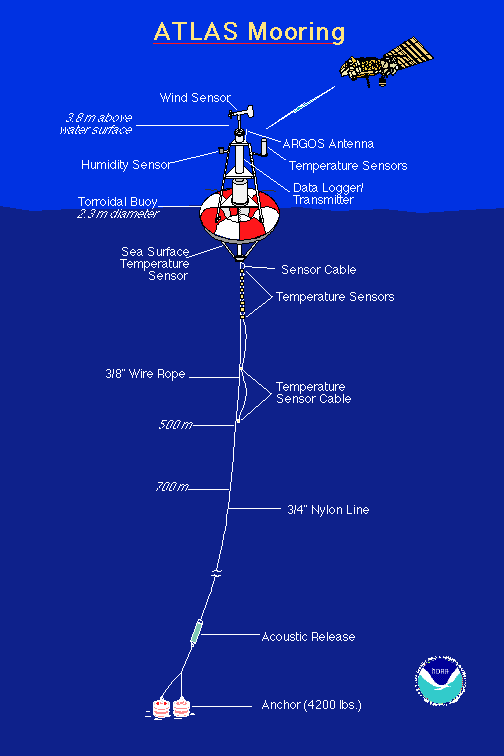
Dr. Paul Freitag, our Chief Scientist, provided some more information about the instruments on the buoys. First, the buoys are anchored to the ocean floor, which is still hard for me to believe. All of the buoys have sensors to measure temperature/relative humidity and an anemometer to measure wind speed along with wind direction. Some of the buoys have sensors measuring precipitation and solar radiation, but not all are equipped to with this expensive instrumentation. The buoy itself (the orange and white donut part) is composed of a foam core surrounded by fiberglass. Below this there is a rigid stainless steel bridle connected to a wire rope which is used for the first 500 meters of the mooring. On these 500 meters of wire rope there are nine subsurface temperature sensors (thermistors) followed by two pressure sensors accompanying two more thermistors. The pressure readings correspond well with measurements of ocean depth. Water temperatures are measured below the surface at 1 meter (m), 20 m, 40 m, 60 m, 80 m, 100 m, 120 m, 140 m, 180 m, 300 m, and 500 m. Below 500 m, eight-strand plaited nylon line is used down to the anchor, with some sites requiring nearly 3 miles of line (see the diagram at http://www.pmel.noaa.gov/images/atlas.gif). The amazing thing is that the subsurface temperature sensors transmit and receive data from the buoy with an inductive coupling technique, which means that they’re not wired directly to the main line, yet data are transmitted along the cable. The sensors simply clamp onto the wire rope that serves as one of the inductive elements. This makes it much easier to assemble and deploy the extremely long cable. One aspect of meteorology that I find fascinating is the instrumentation, so I spend much of my time looking at the wiring and instrument manufacturers and asking the scientists many questions about what and why and how…they haven’t seemed to mind so far.
Here is some more information about the people and activities on the ship. There are 31 people on board (seven of us are women) with bunk space available for only two more. There are 5 officers, 1 cadet, 10 scientists, and the remaining crew members who focus on making the ship and science work efficiently. We all greatly appreciate their help. Everyone eats breakfast from 7:00-8:00 AM (0700-0800), lunch from 11:00-12:00 (1100-1200), and dinner from 4:30-5:30 PM (1630-1730). There is a small store selling candy and snacks, soda, shirts and hats on the ship that is open each night from 1930-2000 hours. We can email from any computer on board (I’ve counted at least 14 computers) and all of our email messages are sent and received in a bundle two times a day around 0900 and 1600. There is a laundry room with three washers/dryers on the second deck forward on the starboard side of the ship. There are two lounges with library materials including books, magazines and board games. Movies are shown every night on two channels in the lounges at both 1730 and repeated at 2000. So, you can see that it’s easy to keep busy on the ship. Two extra treats on this cruise include guitar/music playing sessions for all those who brought their musical instruments on board, and French lessons every other night. Je m’appelle Diane. J

After seeing more flying fish today, I decided to do some research to find out exactly what these fish are all about. I learned that they’re often referred to as “bluebirds of the sea” and that they spread their pectoral fins, glide for a few seconds, and then splash back into the sea. When they swim, their long fins are folded against their body. Flight speeds of up to 35 miles per hour have been monitored and flights as long as 13 seconds covering up to 450 feet have been timed. Photography has proven that they are gliders and not true flyers (all information obtained in “Fishes of the Pacific Coast” by Gar Goodson, Stanford University Press, 1988). I’ll keep my eye on these beauties and attempt to take a photo so you can share this delight!

The first person to answer my question of the day posed in my August 17th log was Tom Taddeo (my incredibly smart uncle from Mechanicsburg, PA – thanks for responding!) who gave the correct answer regarding the definition of pitch, roll, and yaw of a ship. Yes, pitch is when the ship tips in a fore-and-aft direction (from front to back), roll means the ship tips from side to side due to the sea or swell, and yaw means that the ship swings involuntarily from side to side when advancing forward. I’d love to hear from more of you so I can acknowledge more people in my logs.

The afternoon was spent testing the computer and camera equipment that will enable us to connect with all of you via upcoming live webcasts. Fortunately, everything seems to be working very well! We even managed to get a wireless microphone to work. We’ll be testing again tomorrow and hope to have a general broadcast ready to go by the end of the week. Please contact Jennifer Hammond at jennifer.hammond@noaa.gov if you’d like to receive the live broadcast. We’ll be interviewing scientists and talking about life at sea!

We enjoyed a wonderful dinner again tonight and I’m nearly ready for bed. It was great to hear from Dana Tomlinson (our last Teacher at Sea!), Nancy from ASU, and as always, my husband, family members, and friends. I invite more of you to email with questions that you might have about the Ka’imimoana or what it’s like to live on a ship.

Until tomorrow when I discuss CTD’s (what are they, you ask?!? – more tomorrow!)…bon soir.

Question of the day: What is the difference between sea wave height and swell wave height?

More tomorrow…
Diane

P.S. I just walked outside and rain was falling on the buoy deck under bright pink clouds – beautiful!

Diane Stanitski: Day 8, August 18, 2002

NOAA Teacher at Sea

Diane Stanitski

Aboard NOAA Ship Ka’imimoana

August 16-30, 2002

Day 8: Sunday, August 18, 2002

The weather observations at 1700 today were:
Temperature:
 26.0°C
Sea Water Temperature: 26.7°C
Visibility: 12 nautical miles
Wind direction: 055 (on a 0-360° scale) – NE
Wind speed: 20 kts
Sea wave height: 5-7′
Swell wave height: 6-8′
Sea level pressure: 1013.2 mb
Cloud cover: 3/8, cumulus

Today’s quote: “Best be yourself, imperial, plain and true!” – Robert Browning

The crew was abuzz today due to the fact that we were about to deploy a test buoy after surveying a 3×3 mile stretch of the ocean to find an area with a flat surface for the buoy’s anchor to rest upon. The entire exercise took all morning and a part of the afternoon. I interviewed John Bumgardner, our mechanical engineer on the boat, about the buoy array and videotaped a short segment to be used in one of our upcoming webcasts.

A buoy deployment is serious business on the ship. One of two cranes is used to lift the extremely heavy buoy off the starboard side of the ship onto the water. Thousands of meters of durable nilspin and nylon are then spooled out into the ocean behind the buoy with a large anchor (a railroad wheel) weighing approximately 2 tons dropped as a final way to secure the buoy in its location and anchor it to the ocean floor (see photos in the photo log). The buoy drifts off into the sea for a few km as the ship slowly drifts in the opposite direction so that the rope doesn’t become tangled. An acoustic release device is then discharged into the water, which will allow the buoy to become detached from the anchor after it’s at the bottom of the ocean. This will be handy when the buoy is retrieved from the water at the end of September during the return of the KA to Honolulu.

The deployment was successful except for one rope that was caught over the sonic wind sensor. A group of us decided to ride the RHIB to the buoy in order to pull the rope off of the sensor. It was a rough ride through the 6-8′ swells, but boy was it fun! We all hung on and received a nice salty shower during our return to the ship.

While all of this was going on, Larry, our Electronics Technician, hooked me up to my email account so that I could keep in touch with all of you. He also downloaded software so that I could provide photos of my experience for you to view. Larry keeps the ship rolling with his expertise in so many areas. We’re definitely lucky to have him on board.

After turkey, stuffing and mashed potatoes for dinner, John videotaped me on the back deck in front of a beautiful sunset. I then came inside for a short French lesson. Takeshi, our foreign observer, is from France and is teaching us some basic French before our arrival in Nuku Hiva, the French Marquesas. It’s all coming back to me after 3 years of French in High School – definitely worthwhile classes to take in school.

I’m off to bed after a long day in the fresh air. Looking forward to tomorrow’s adventures.

Today’s question: What percent of the ocean’s water is saline?

All the best,
Diane

Dana Tomlinson: Day 9, March 9, 2002

NOAA Teacher at Sea

Dana Tomlinson

Aboard NOAA Ship Ka’imimoana

March 1 – 27, 2002

Date: Saturday, March 9, 2002

Lat: 5°N
Long: 110°W
Seas: E/NE 2-5 ft.
Visibility: unrestricted
Weather: partly, occasionally mostly cloudy
Sea Surface Temperature: 78-82°F
Air Temp: 87-76°F

Today, we did our first recovery/deployment of a buoy. What a fascinating 6 hour process. I was very impressed by the way the entire crew worked together as a team to make this complicated, and potentially dangerous, process happen.

At first light, two scientists (Brian and Nuria) motored out to the buoy (which was about 10 miles from where it should have been) from the Ka’imimoana in a small craft. They tied the buoy to a rope which was winched up back on deck. The buoy was then pulled to the ship and carefully hoisted aboard (in 6-8 ft swells with about 15 knot winds). It was placed over a hole in the deck so that Raye could scrape the barnacles off from below. (more barnacle talk tomorrow) It was missing its anemometer – lost at sea! Then the scientists started to winch in the wire which holds, at regular intervals, the thermometer pods, or Thermisters, which have been on this buoy for the past year collecting temperature data. After those are cut off, all of the 500 m (one spool) of wire is spooled. (We found a mass of fishing line that was snagged on the wire. This probably helps to account for why the buoy was 10 miles off. The fishing boat that was attached to the line probably pulled it.) Then comes 5-6 spools of white nylon rope to pull up. Then, there’s another 50 m of nylon rope, at the end of which is an acoustic coupler – a device that automatically releases the anchor line from the anchor by remote. Done with recovery!

To deploy the new buoy, it’s not exactly a reverse process because the buoy goes in first, followed by the line and then anchor last. The buoy (with anemometer!) gets hoisted over the side by crane and released with the wire on board attached to it. The wire starts getting released and the Thermisters are attached to the line at their intervals, then the rest of the wire is released and then the many spools of nylon rope. Then the acoustic coupler is attached and finally the anchors are carefully placed into the water. The ship then motors back to the buoy, which has floated over a mile away, to make sure it has ended up in the correct location and is floating properly upright. The scientists have purposefully deployed the anchor at a certain location knowing that the anchor will pull the buoy back some, but not all of the way. The barnacle talk will wait for tomorrow since the buoy explanation took so long! Stay tuned!!

Question of the Day: 

At the end of the url for this website and on every buoy we recover and deploy, it says “TAO.” What does TAO stand for?

Answer of the Day: 

Mr. Whitham’s class in San Diego was the first to respond with the correct answer. To change Celsius into Fahrenheit, one must take the Celsius number, multiply it by 9/5 and then add 32. C x 9/5 + 32 = F So, 27.6C is about 81F. (A hint that an Australian friend of mine told me is, if the Celsius number is in the 20’s or higher, just multiply the Celsius number by 3 and you’re close enough. In this case, pretty darn close!!).

Til tomorrow,
🙂 Dana

Dana Tomlinson: Day 5, March 5, 2002

NOAA Teacher at Sea

Dana Tomlinson

Aboard NOAA Ship Ka’imimoana

March 1 – 27, 2002

Date: Tuesday, March 5, 2002

Latitude: 15 N
Longitude: 111 W
Seas: N/NW 2-5 ft.
Visibility: Unrestricted
Weather: Partly Cloudy
Sea Surface Temp: 72-76F
Winds: NE 5-10
Air Temp: 78-65F

Hello again from the sunny Pacific! Today was another wonderful day in paradise. We were actually visited by some boobies doing some aerial maneuvers around the ship. We also saw numerous flying fish who I don’t think were visiting, but trying to get out of our way! It was my first sighting of flying fish. I always figured that they’d soar out of the water and fall back in, but, as often happens, boy was I wrong. These fish (very slender and smaller than I thought -looked like maybe 8-10 inches long) burst out of the water and then literally fly. They use their pectoral fins as wings and some easily flew for 50 yards. Amazing.

Since we are still in transit to the first buoy (arriving Wed 3/7), I spent today on camera in tests to get our technology all set for the live web feeds we will be doing for schools around the country (and in a few other countries, too). If you are a teacher who would like to set up a live webfeed for your classroom, please email me, and I’ll connect you with the people who will make it happen.

The scientists continue to prep for work they’ll be undertaking any day now. Since I don’t have anything very scientific to discuss today, I think I’ll take this opportunity to give you information on something I’ve been getting LOTS of questions about … the food!

JoseFelipe from San Diego was one of the first to ask! The mess (it’s actually very neat, but that’s what they call the cafeteria) is open to feed us three times a day: from 0700-0800, 1100-1200 and from 1630-1730. They are strict about the times. Clementine and Sandra are the cooks and they do a terrific job feeding the 30 of us on board a great deal of variety. For breakfast every day, they’ve had a choice of hot or cold cereals, waffles, pancakes, and some sort of egg dish. For lunch, there is always a salad bar, and usually sandwiches and a soup, and then a couple of main dishes. For dinner, you usually have at least 3 dishes to choose from. Dessert at lunch is usually ice cream or fruit, and for dinner it’s usually something VERY fattening. Tonight, it was the richest chocolate cake I’ve ever eaten. During any other hours of the day, the mess is open for the snacks they have available: bread, peanut butter, all of the drinks, salad, crackers, etc. So far, my favorites have been the Chinese soup, the chicken curry and the Caesar salad (at three different meals and all made from scratch). We are a lucky crew. Thanks, ladies!!

Question of the Day: 

When looking at a forecast, what does SST stand for?

Hint: you can find it in my daily log.

Answer of the Day:

Vanessa P. from San Diego was the first to ask me what the #2 and #3 most frequently asked questions of me were before I left on my voyage. Here are those questions and answers:

#2 Are there any other women on board with you?
Answer: Yes, there are a total of 8 women on board and 22 men.

#3 How did you get chosen for this?
Answer: I’m not really sure. My best guess is that the folks who decide these things at NOAA liked the fact that I wrote well when I filled out my application, they liked that I have done a lot of things in outdoor education, and perhaps they liked the fact that I used to be a flight attendant so they knew that I can travel and take care of myself. I really don’t know, but I’m sure glad they did!

Til tomorrow,
🙂 Dana

Dana Tomlinson: Day 3, March 3, 2002

NOAA Teacher at Sea

Dana Tomlinson

Aboard NOAA Ship Ka’imimoana

March 1 – 27, 2002

Date: Sunday, March 3, 2002

Latitude: 25.5 N
Longitude: 114.8 W
Temperature: 70 F

Science Log

Research has not yet started.

Travel Log

When we went to bed last night, the moon was a harvest color just hanging on the horizon and there were 30 knot winds crossing the bow of the ship. The seas had picked up considerably and this morning we had fairly high surf with waves breaking, forming white caps wherever we looked. It wasn’t scary, but it was rough. By the afternoon, however, we had the predicted 2 to 4 foot seas, partly cloudy weather with temperatures in the mid-70’s – just lovely.

The crew continues to prepare for the many experiments and tests they will perform. Today, Ben and Brian used one of the cranes on board to move a Doppler radar device into position for future deployment. My roommate is an employee with MBARI (the Monterey Bay Aquarium Research Institute). She is going to be studying the barnacles that collect on the bottoms of the buoys that are brought on board. She’s been busy preparing her collection bottles, sewing netting to hold the samples and teaching me the difference between the types of barnacles to be found!

I’m looking forward to helping her with some of her work. More tomorrow on the other activities I’ll be involved with. I’d love to hear from you. Please email with questions and I’ll be happy to get back to you and to use the answers to some of them in this daily log.

Til then, here’s to FAIR seas and following winds!
Dana