Victoria Cavanaugh: Newport, Oregon Bound!, April 12, 2018

NOAA Teacher at Sea
Victoria Cavanaugh
Aboard NOAA Ship Fairweather
April 16 – 27, 2018

MissionSoutheast Alaska Hydrographic Survey

Geographic Area of Cruise: Southeast Alaska

Date: April 12, 2018

Weather Data from My Classroom at School

Latitude: 42.3306° N
Longitude: 71.1220° W
Sea Wave Height: N/A
Wind Speed: 16 km/h
Wind Direction: SW
Visibility: 14.5km
Air Temperature: 5.6oC  
Sky:  Scattered Clouds

Personal Log

Greetings from Brookline, Massachusetts!  I am a 7th grade math teacher at the Edward Devotion School, where I have the wonderful opportunity to work with 80 creative and enthusiastic students each day.  I applied to the NOAA Teacher at Sea Program as I’m eager to bring real-world math to the classroom, or maybe to bring my classroom to the real-world math. 🙂 The 7th graders are currently in the midst of our data and analysis unit, and I can’t wait to learn more firsthand about how NOAA scientists gather, graph, and analyze data.  I look forward to sharing my learning with my class, and I’m excited about to what future class projects this opportunity may lead.

Math Class Fish
Our 7th Grade Math Class Fish, Swim Shady, & the Inspiration for Our Aquaponics Garden Design Project


Previous to teaching 7th grade math in Brookline, I taught for nearly a decade in El Salvador.  I’m happy to be able to share this adventure with students there as well.

El Salvador group photo
Visiting with Some Former Students & Family along the Ruta de Flores, El Salvador

In just a few days, I will fly from Boston, MA to Portland, OR, and from there I’ll board NOAA Ship Fairweather in Newport, OR.  It was a nice surprise to learn I’d begin my journey in Newport as I first visited Oregon when I was in seventh grade myself.  From there, we’ll sail towards Southeast Alaska.

Newport beach
My Brother and I (as a 7th Grader) Visiting the Beach in Newport, OR

While aboard NOAA Ship Fairweather, I’ll be participating in a hydrographic survey, which entails working with scientists to measure and describe oceanic features that can affect maritime navigation. According to NOAA,  “Alaska’s charts are in need of updating, especially in the Arctic region where some soundings date back to the work of Captain Cook in the 18th century.”  Conducting a hydrographic survey of the region is especially important because many towns and villages in Alaska are reachable only by boat or plan, so accurate and updated navigational charts will benefit all who live and travel through the area.

One aspect of the Alaska Hydrographic Survey Project, I’m eager to witness is the way in which scientists, technicians, and cartographers utilize some of  the same geometry and algebra concepts we’ve been studying in seventh grade math this year in their work aboard NOAA Ship Fairweather.


Did You Know?

NOAA Ship Fairweather’s home port is Ketchikan, Alaska, which will also be where I’ll disembark at the end of my trip.

Fairweather
NOAA ship Fairweather, in front of its namesake, Mt. Fairweather. Photo courtesy of NOAA.

Dana Kosztur: Unexpected Visitors, April 11, 2018

NOAA Teacher at Sea

Dana Kosztur

Aboard NOAA Ship Pisces

April 5-18, 2018

Mission: SEAMAP Reef Survey

Geographic Area of Cruise: Gulf of Mexico

Date: April 11, 2018

Weather Data from the Bridge

Lat: 29° 54.7331′ N Long: 087° 12.1562′ W
Air Temperature: 22.5°C (72.5°F)
Water Temperature: 21.29°C (70°F)
Wind speed: 5.8 knots (6.7mph)
Conditions: blue sky, flat seas

Science and Technology Log

This week I have learned a lot about the reef fish studied in this SEAMAP survey. I have learned how to weigh the fish and take various length measurements. I have also learned how to examine the gonads and distinguish a male from a female.  I can now properly remove the otolith bones from the otic capsule that is located at the base of the fish’s skull.


We have had some unusual catches that have provided great learning experiences as well.  The bandit reel caught a sharksucker on the line as it returned. This fish belongs to the Remora family.  It attaches to sharks and other marine animals. This was a really unusual creature to observe.

Dana and shark sucker
TAS Dana Kosztur displays a sharksucker captured on the bandit reel.

The camera arrays had fireworms hitch a ride to the deck from the bottom of the gulf. These guys look like large spikey caterpillars. They have venom in their bristles that can cause a painful sting.  

Fireworm
This fireworm hitched a ride on a camera array.

Personal Log

Today was a beautiful day.  The water is such a beautiful blue.  The sky was cloudless last night so I finally got to look at the stars.  The night sky seems much more vast and bright away from the light pollution on land.  The stars are amazingly bright. I am enjoying life on the ship but I do miss home. I have a greater respect for those that work away from home for long periods of time.  Teamwork and a positive attitude seem to be the lifeblood of this NOAA vessel and that makes it much easier to adjust.

Did You Know?

Many birds will often land on the vessel to rest during their migration route across the Gulf of Mexico.     

Barn swallows
Migrating barn swallows

Waves transmit energy, not water.

Cow at sea
Cow at sea

Questions from students:

Why do scientists need to know what types of fish are on the reef?  

It is important to manage and maintain the reef fish species because they are often over-fished.

Scamp grouper
Scamp grouper


Tom Jenkins: Introductory Post, April 6, 2018

NOAA Teacher at Sea

Tom Jenkins

Aboard NOAA Ship Henry B. Bigelow

April 10 – 27, 2018

Mission: Spring Bottom Trawl Survey

Geographic Area: Northeastern U.S. Coast

Date: April 6, 2018

Introduction

Now that word is out about my NOAA Teacher at Sea selection, I am being asked many questions about my upcoming research mission.  The truth of the matter is that I am unsure exactly what to expect. While the administrators of the program have done a great job of communicating information, NOAA has many different objectives.  Even the missions, which are annual events, appear to be unique experiences as there are so many variables involved when doing research at sea.

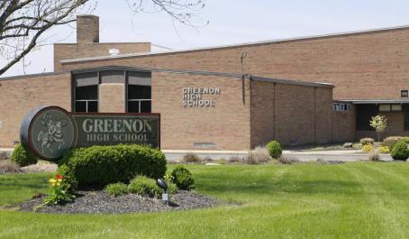
One thing I know for sure is that almost 3 weeks out at sea seems like a long time, especially for someone that has lived in Ohio for his entire life.  Clark County, Ohio (where I teach 8th Grade Science and STEM at Greenon Jr./Sr. High School) is probably what most people think of when they think of “Midwestern living.” A mixture of agriculture and fading industry, we are a close-knit community, which is something John Cougar Mellencamp would find familiar.  While we have plenty of creeks and lakes, many of my students have never seen the ocean. I have been fortunate enough to go on a handful of cruises, but have never been at sea for more than 10 consecutive days, and those included stops along the way.  I am fairly confident I will do fine, but I am also packing motion sickness medication to be on the safe side. Fingers crossed!

Greenon Jr/Sr High School

I will live aboard the NOAA research vessel Henry Bigelow (Follow this link for additional information).  This 209 feet long, state-of-the-art, research vessel is likely a giant step up from what you may have seen on “Deadliest Catch.”  While it is definitely built for collecting fish and other biomass, it conducts trawl sampling (think of a long, specialized net that is dragged behind the ship).  NOAA Ship Henry Bigelow is equipped with many advanced features including a modern wet lab which allows scientists (and me!) to sort, weigh, measure, and examine the catch.  This information is then added to NOAA’s extensive database which provides our country’s scientists with valuable information regarding the status of the organisms that reside within the ocean.

downloadfile
NOAA Ship Henry B. Bigelow

Another question that I am frequently asked is, “What about your students?”  The best part about this arrangement is, not only will I be immersed in authentic scientific research (which will add value to my educational practice), but the use of Google Classroom will allow my students to share my adventures from the field.  In addition to frequent online updates where I will answer questions and discuss ongoing research and associated phenomena, my students will use NOAA educational resources to learn more about our oceans and the life within them.

As I prepare to leave in a few days, I am full of emotion.  I am obviously very excited to be afforded this unique opportunity.  I love travel, adventure, and learning, so this research cruise will be a perfect fit.  I will work alongside 37 people (sailors, fisherman, scientists, and engineers to name a few) who are very good at what they do for a living.  I can’t wait to pick their brains to learn how I can incorporate their knowledge into my classroom. All of that being said, I will definitely miss both my family and my students.  I look forward to returning home and sharing my experiences with them.

Please check back over the next few weeks as I will write additional blogs regarding my NOAA Teacher at Sea adventure.  I would love to make this blog series interactive, so if you have any questions, please post them in the comments section below.

Dana Kosztur: Cruising with Camera Arrays, April 8, 2018

NOAA Teacher at Sea

Dana Kosztur

Aboard NOAA Ship Pisces

April 5-18, 2018

Mission: SEAMAP Reef Survey

Geographic Area of Cruise: Gulf of Mexico

Date: April 8, 2018

Weather Data from the Bridge

Lat: 29o 20.6309′ N      Long: 087o 46.1490′ W
Air Temperature: 18.1oC (64.5oF)
Water Temperature: 22.29oC (72oF)
Wind speed: 10.81 knots (12.4 mph)
Conditions: cloudy,  1 to 2 ft seas

Science and Technology Log

The most important equipment on this mission are the camera arrays. Most of the data collected are dependent on these cameras.  I mentioned in my last entry the two types of camera arrays used in this survey are the SatCam and the RIOT.  The video taken from these camera arrays is stitched together in a five-panel single view. The videos are reviewed and each species that appears is counted and recorded.  Images help the scientist determine the population of fish at a given site. The RIOT is a two-stacked spherical camera housing unit that contains 5 horizontal cameras and one upward facing camera.  The RIOT is the more expensive of the two arrays, but it gives the scientist a greater ability to measure fish when they are captured in the dual videos.  


IMG_0759
deploying the RIOT


Over the past few days, we have caught several species of fish on the bandit reels. We have caught red snapper, vermilion snapper, and red porgy. These lines have 10 baited hooks and they are dropped into the water on a randomly selected site.  In order to obtain a proper sample of the fish, very little human interaction is made with the reel or the line. This leaves out any fisherman bias and allows for natural sampling of species on the site.  The hook sizes are rotated with each drop. The hooks sizes are 8, 11, and 15. If reel 1 starts with size 8 hook, it will have size 11 on the next drop, and then 15 on the third. Each reel has a different rotating pattern.  This allows each hook size to be in the water over the same site. The data will help determine if a certain hook type is favored by a species of fish.


IMG_07742
recording red snapper data


IMG_0756
class mascot


Personal Log

My students will return to school tomorrow from spring break.  I am a little sad I am not there with them.  They wrote letters for me to read while I was away. I have read some of these already and they are pretty funny.  I want to reassure them that I will not fall overboard and that I am eating well.  I will answer student questions on the bottom of my blogs.

We are in the Gulf of Mexico about 70 to 80 miles offshore, on the Mississippi-Alabama Continental shelf.  I have not been this far out in the gulf before today. It is pretty humbling to look out and just see blue water. The sunrises and sunsets are spectacular. You can’t always see them though. The weather has been pretty gloomy the last two days, so I was unable to see last night’s sunset or this morning’s sunrise.   We had a storm yesterday followed by the much cooler weather today.  I hope this is the only cold snap we get.  I am not a fan of cold boat work.

Did You Know?

Turbidity is how cloudy the water is based on the suspended solids. The higher the turbidity the more sediment, algae and other solids are suspended in the water.  Clear water has low turbidity.

Questions from students:

What is hydrography? The science that measures and describes the physical features of bodies of water and land close to these bodies of water.  Multibeam echosounders are used to obtain hydrographic data.

New species that I have seen:  Red Porgy:  Pagrus pagrus

                           Vermilion Snapper:  Rhomboplites aurorubens


IMG_0773
Red Porgy teeth


Dana Kosztur: Sailing on the Gulf of Mexico, April 5 & 6, 2018

NOAA Teacher at Sea

Dana Kosztur

Aboard NOAA Ship Pisces

April 5-19, 2018

Mission: SEAMAP Reef Survey

Geographic Area of Cruise: Gulf of Mexico

Date: April 5 & 6, 2018

Weather Data from the Bridge

Lat: 29o 22.895′ N      Long: 087o 59.992′ W
Air Temperature: 22.9oC (73oF)
Water Temperature: 22.83oC (73oF)
Wind speed: 14.89 knots (17.13 mph)
Conditions: partly cloudy skies and the seas are pretty smooth

Science and Technology Log

I have been aboard Pisces for over 24 hours.  I have learned a lot about the technology used on the ship.  This vessel has a Simrad ME70 multibeam echo sounder. This device will create a bathymetric map of the survey areas that have been randomly selected for this mission.

The crew is on the third leg of a four leg reef fish survey.  This SEAMAP survey will use cameras as its primary instrument to study the population of fish in the survey area. There are two types of camera arrays the scientist use.   The SatCam has 7 cameras that allow a 360-degree view of the ocean floor.  The RIOT is a double-stacked version with 12 cameras. The RIOT allows the same visuals as the SatCam but can also be used for fish measurement.


IMG_0661_resized
RIOT (Reef Information Observation Tower) on deck


IMG_0633_resized
SatCam ready to deploy

The SatCam and RIOT are rotated, one is deployed each site. The boat is positioned over the sampling site and the cameras are released into the water. The cameras free fall to the bottom and are buoyed. They are left to soak for 30 minutes before they are picked back up.  The camera begins recording 5 minutes after it hits the bottom to allow the sediment to settle, it then records for the remaining 25 minutes.

After the camera is sent into the water, the ship moves away and a CTD is released into the water in much the same way.  The CTD is an electronic instrument package that sends back real-time data of water conditions such as salinity, temperature, density, and light filtration versus water depth.


IMG_0618_resized
CTD tests the water column for conductivity, temperature, and depth


Bandit reels are also used in this survey.  There are three of these reels mounted on the starboard side of the boat. The line on each has 10 baited hooks.  This leg of the trip we are only fishing every other stop. The first round of fishing with the bandit reels yielded no fish. The second time the stern bandit reel caught silky sharks.  Three sharks made it to the deck to be weighed, measured and then safely released. The next time we used the reels two large red snappers were caught. They were weighed and measured. The otoliths and gonads were removed from each specimen.  These will be used to determine age and reproductive abilities.


IMG_0640_resized
Bandit Reel 1


IMG_0687_resized
Red Snapper caught on Bandit Reels


I think I am getting adjusted to life aboard the ship. We are only working during daylight hours so I won’t have to change my sleeping schedule. I am working with a team of 4 scientists and they are doing a great job explaining everything and answering my questions. There is so much to learn about and I want to know it all.

I am taking medication to keep from getting seasick and it is working, but I was so exhausted yesterday that I went to bed after watching the sunset.  I hope that will get better in the coming days. I haven’t lost my excitement about being here.  Everything out here is interesting.

Did You Know?

A snapper otolith can tell the age of the fish.  The otolith is an ear bone. When removed from the fish and cut in half, the rings can be counted.

  • Animals Seen Today

Bottlenose Dolphin (Tursiops truncatus)

Silky Shark (Carcharhinus falciformis)

Red Snapper (Lutjanus campechanus)