A sign hanging in the airport when I landed in Dutch Harbor. If this is where I started and my most recent coordinates are below, which way have I been traveling?
Weather Data from the Bridge on June 7th, 2018
Latitude: N 55° 22.897
Longitude: W 164° 20.546
Sea Wave Height: 2-3 ft
Wind Speed: 13 knots
Wind Direction: 270 degrees
Visibility: 8 knots
Air Temperature: 7.5° C
Sky: Grey and Cloudy
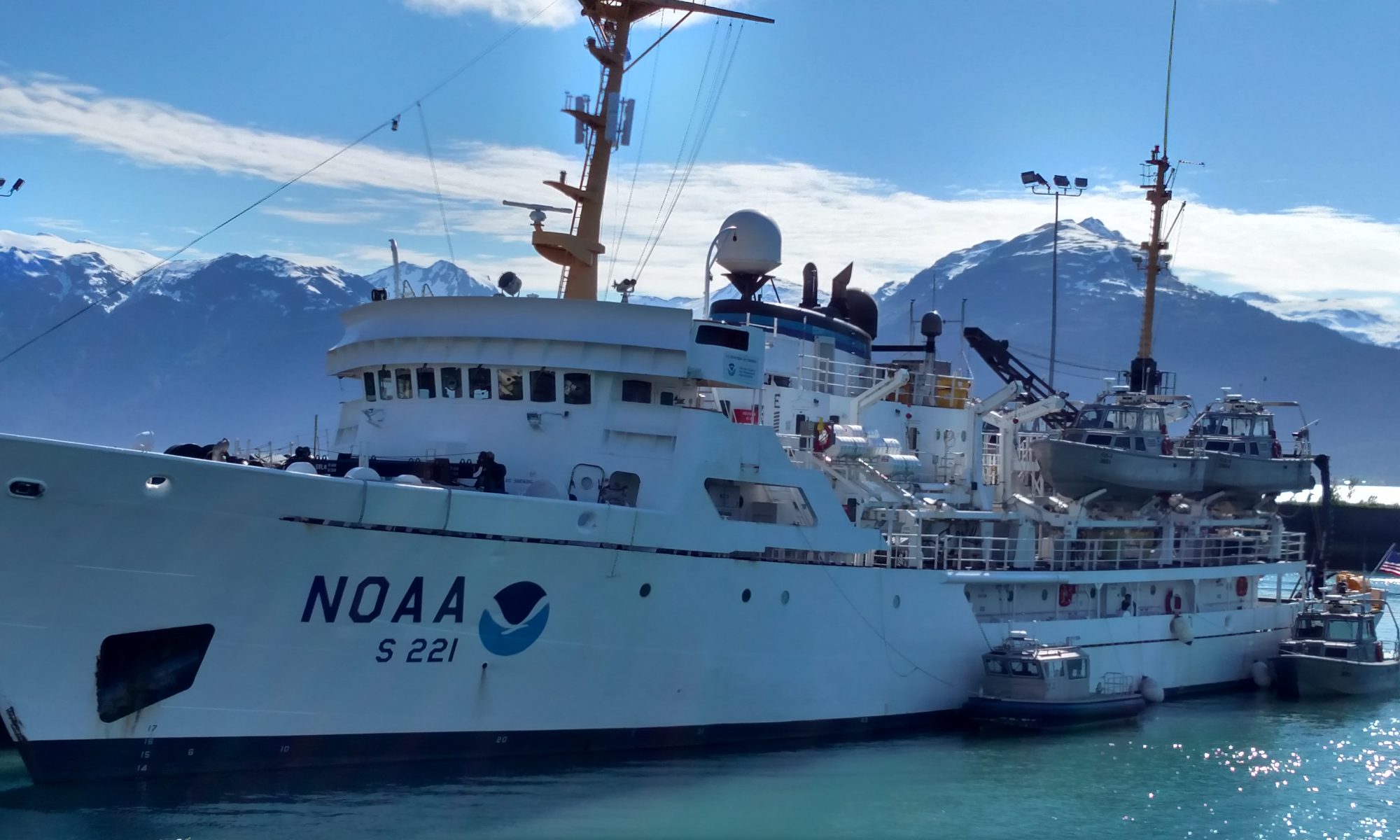
Photo of NOAA Ship Oscar Dyson at port in Dutch Harbor, AK.
Science and Technology Log
On this leg of the Research Cruise in the Eastern Bering Sea I will be helping a team of NOAA scientists collect data about a fish species called Pollock. The data that are collected will help to set the limits for how much pollock the fishing boats are allowed to catch. The data also allow scientists to track the populations of the pollock to look for patterns. For additional information on Pollock, visit the NOAA fisheries website here.
During the survey, acoustic (sound) signals will be sent into the water by transducers at different frequencies and these acoustic signals will bounce off of the objects in the ocean and bounce back to the ship where the echoes will be picked up by the transducers. The data collected from each echo is presented visually to the science team. When we reach a spot where a lot of the acoustic signals returning to the boat indicate the presence of fish, a trawl sample will be taken at that location. A trawl survey includes putting a large net into the water and scooping up a sample of all of the living things in that location. Once the trawl haul is brought onto the boat, it is taken to the fish lab where the fish are identified and measured.
Photo of the Fish Lab on NOAA Ship Oscar Dyson
The area being surveyed is the Eastern Bering Sea and for this study is divided up into 28 different transects have been mapped out and are spread 20 nautical miles apart. We will start at northern point of the first transect and travel south until we reach the bottom of it. Once we reach the bottom of the first transect we will travel 20 nautical miles west to the southern tip of the second transect. We will then travel north along this second transect until we reach the top and then travel the 20 nautical miles west until we reach transect 3. This will continue throughout my time on the ship, and on the 2 other legs of this journey. On this first leg of the research cruise, the aim is to survey and sample from 16.3 of the transects which will total a journey of 2627 nautical miles on the transect lines.
According to the NOAA National Ocean Service Website, “A nautical mile is based on the circumference of the earth, and is equal to one minute of latitude. It is slightly more than a statute (land measured) mile (1 nautical mile = 1.1508 statute miles). Nautical miles are used for charting and navigating.”
Map of transect lines for NOAA Ship Oscar Dyson over the 3 legs of the Eastern Bering Sea Pollock survey. Current location is shown by the yellow boat. Can you find it? Hint: It’s near the vertical lines on the right. First transect is the farthest on the Eastern (right in this photo) side.
Personal Log
Photo taken on the stern of NOAA Ship Oscar Dyson. Photo Credit: Sarah Stienessen
It was a long trip getting to Dutch Harbor, Alaska, but it has already been worth it! I am on the Island of Unalaska, which is a part of the Aleutian Islands of Alaska. The main port city is called Dutch Harbor, or commonly just “Dutch”. This is such a beautiful place that I probably never would have seen otherwise. There are mountains filled with grasses, berry bushes, and wild orchids as well as snow-topped peaks and natural waterfalls. There are bald eagles everywhere and foxes that are so fluffy they almost appear to be dogs from far away. Looking into the water you can see a few scattered otters floating on their backs and the occasional harbor seal.
This photo was taken from the bow of NOAA ship Oscar Dyson at port in Dutch Harbor, AK.
As soon as I landed in Dutch, I was greeted by two of the scientists that I will be working with, Matthew and Sarah. They took me to NOAA Ship Oscar Dyson to drop off my luggage before we all went out to dinner. I was pleasantly surprised to find out that I actually had my own stateroom. Due to the number of female scientists and us being on the same work shift, we were both able to have our own rooms. The rooms are so much nicer than I had anticipated them to be! The mattresses are comfortable, I have a desk space, there’s a television (that I will probably never watch) and I have my own bathroom as well.
Photo of my stateroom and bathroom on NOAA Ship Oscar Dyson.
Photo of my restroom on NOAA Ship Oscar Dyson
After we had dinner and returned to the ship, I went on a mini hike with one of the members of the science team and we went to view this amazing natural waterfall. You wouldn’t know it was there if you weren’t looking for it. There is so much more that you can do when the sun is up for most of the day. At 11:30pm (the latest i’ve stayed up so far) it is still light outside. There are so many clouds that the sky looks pretty grey, and there are a ton of clouds, often hiding the tops of the mountain peaks.
Photo of TAS Lacee Sherman in front of a waterfall in Dutch Harbor, Alaska.
The next morning I woke up and went for a nice long walk along Captain’s Bay and sat and had coffee on the rocks and just admired the incredible view. It is so much more beautiful here than I had imagined. Later a few of us went for a drive around the island and a few people surfed in the ocean, but I wasn’t brave enough to get in the cold water this time.
Photo taken on Unalaska
Since we will be on the ship for a while (23 days) we stopped at the grocery store to bring a few things onboard that we want to have in addition to our regular meals prepared on the ship by the stewards. I decided that I wanted to bring some fresh fruit, not realizing that I would be paying way more than I expected for them! Everything is expensive here!
$26 dollars worth of fruit in Dutch Harbor, AK.
Did You Know?
Even though we think of Bears and Moose being found all over Alaska, they are not found on the Island of Unalaska at all!
Animals Seen
6/4/18 – Bald Eagles, Fox, Otters
6/5/18 – Bald Eagles, 4 Foxes, Otters, Harbor seal, Jellyfish (3 different species)
6/6/18- Bald Eagles, Jellyfish (2 species), Humpback Whales!!
A fox spotted on 6/5/18 in Dutch Harbor
These are crab fishing “pots” that are used by Alaskan Fisherman to catch crab. How many bald eagles do you see in this photo?
Mission: Rockfish Recruitment and Ecosystem Assessment Survey
Geographic Area of Cruise: Pacific Ocean along the California Coast
Date: June 6, 2018
Data from the Bridge
Latitude: 36° 59.462 N
Longitude: 122° 31.056 W
Wind Speed: 12.77 knots
Wind Direction: Northwest winds
Wave height: 2 to 3 feet with 4-6 foot swells
Air temperature: 12.76° C
Science and Technology Log
Our first official night on the Job was Sunday, June 4th. My shift is technically 6:00 pm to 6:00 am, but we could not begin trawling until the evening when skies were dark. If fish can see the net, they can avoid it. The method we use to catch fish is a midwater trawl, also known as a pelagic trawl, because the net fishes in the water column. It’s called a modified Cobb midwater trawl net. It has a cod end, the narrow end of a tapered trawl net where the catch is collected during the trawl.
Diagram of a Trawl net used on NOAA Ships
Before we lower the net, the water around the ship must be clear of marine mammals. Thirty minutes prior to each trawl, someone stands the marine mammal watch on the bridge. Once the net is deployed, someone must be watching for marine mammals outside the entire time. If any marine mammals are spotted (this includes dolphins, porpoises, seals, and sea lions), we report it to the officer on the bridge. The rule is that if we spot a marine mammal, the net must be hauled back in and we sail a mile away from the sighting. Marine mammals are protected and we do not want any caught in the net.
When the net is in the water, we trawl for 15 minutes at 30 m deep. Optimal speed is about 2 knots, but that is weather dependent. During this time, our deck crew, and Survey Technician monitor each step of the haul, reporting back to the officer on the bridge. As they haul the net in, the deck hands and Survey Technician work together to make sure the catch goes into the bins for sorting.
The winch used to deploy and haul in the trawl net on the Reuben LaskerSurvey Technician Jaclyn Mazzella, Deck Hands Ethan Skelton and Raymond Castillo, and NOAA Fisheries Intern Thomas Adams dropping the cod end of the net into a bin to collect our catch.First catch of the first trawl. Some fish and squid are present, but this catch was dominated by salps and pyrosomes.
I didn’t know what to expect from our first catch. Maybe we would have some fish, crabs, squid…However the first catch brought something I never saw before. Lots of Thetys!
Thetys
Thetys are a type of salp. Salps are planktonic, colonial tunicates from the phylum Chordata. We also had pyrosomes, another type of colonial tunicate. They are efficient feeders, filtering particles of plankton from the water. It is expected that in areas where salps are prevalent, one can expect to find less of other species from the same trophic level. For this catch, that happened to be the case.
Pyrosomes, another type of planktonic, colonial tunicate.
As of today, I officially completed 3 shifts on the job, which included 12 trawls in total. It seems that each catch was dominated by 1 or 2 species. There were other species present, but we had to sort through the catch to find them.
We had a catch that was loaded with anchovies, another with krill, and one full of pelagic red crabs. I find this to be one of the most interesting parts of the work, anticipating what we will find. There are many variables that can impact the productivity of an ecosystem, and therefore can determine what we find. Things like salinity, sea surface temperatures, upwelling, proximity to land or open ocean, and human impact, can all influence an ecosystem.
This is me with Fisheries Intern Thomas Adams, stunned by the amount of anchovies we had in this catch. Photo by Keith SakumaThis catch consisted predominantly of krill species. Some catches will have 3 to 4 different species of krill
So, what do we do with our catches once we have them? We count them, and there is a method to the count. Depending on the size of the catch, we may measure out 1,000 ml, 2,000 ml, or 5,000 ml. We start with that first bucket and count every individual (species like krill or salps are measured by volume). The numbers are reported to Keith Sakuma, our chief scientist, and recorded in a handwritten data sheet, then transferred to an excel document. After the first bucket, we may focus on sorting for all other species except the predominant species. For example, for our large anchovy catch, we sorted through approximately 60 liters of fish. We didn’t count every single anchovy, but based on our primary count, we can use the total volume to estimate. However, we sort through looking for all other species and record the findings.
Here we are counting the first 5,000 ml bucket of anchovies. Here you can see we separated out the other species and count them as well.Here is the team starting clockwise from the left: Melissa Monk, Stephanie Oakes, Thomas Adams, Becky Miller, and Kimberly Godfrey. Photo taken by Keith Sakuma
We will record each species we find, and then we have a list of specified species that need to be measured. We take the first twenty specimens of each so we have a record of the average size fish caught in that specific location and time. We focus on measuring the species of fish that have the most ecological and economic importance. These are the prey and those that are consumed by us. Therefore, they are also likely to suffer from human impact. Learning about these species are important to the understanding of what makes them successful, and how to mitigate the things that negatively impact their productivity.
This is me, measuring species of focus for this survey. Afterward, we bag and freeze those needed for further analysis back on land, and the rest get washed back to sea.Electronic caliper used to measure the specimens. It has a USB cable that connects to the computer and immediately records data into a spreadsheet.This data sheet is a record of all the measured species from our catches.
So far this is our routine. Tonight, we had a break from trawling as we transit up to Davenport, just North of Santa Cruz. The current conditions are not favorable for trawling, so we will get back to work tomorrow evening. While we take it easy, our NOAA officers navigate the ship up the coast. I had the opportunity to speak to our Executive Officer (XO), Lieutenant Commander Emily Rose.
How did you come to work for NOAA?
I went to the University of Hawaii and got my degree in Meteorology. From there, my friend referred me to someone who currently worked in the NOAA Corps. The things she told me about the job piqued my interests, so I applied. I was selected in 2008. There was a 5-month training period, and then I was stationed in Hawaii on the Ka’imimoana, a ship that has since been decommissioned. I was sent to Santa Rosa, CA to work for National Marine Fisheries Service (NMFS) during my first land assignment, then I became the Operations Officer aboard the Okeanos Explorer. Before I joined the Reuben Lasker, I was stationed at the National Centers for Environmental Information (NCEI) in Boulder, CO for 2 years.
Since you have a degree in Meteorology, do you get to use what you’ve learned for your current position?
Every time I’ve been on a ship, I’ve been the defacto weather officer. On the Reuben Lasker, I haven’t had to do too much with weather so far, but on other assignments I’ve done weather presentations and helped others like the CO (commanding officer) interpret weather patterns, and just to provide information to those who are interested in learning. It’s is not a career in Meteorology, but having a degree in a science that relates to what NOAA is beneficial. You use critical thinking skills throughout the job. If there is a challenge, you can come up with a solution. You also have math and physics, and a basic understanding of how things work. All these things help make operations successful.
What is the most important part of your job now?
The most important part of my job is to manage the ship’s crew. I make sure they are put first. I manage their time and attendance, their pay, their leave time, any personnel issues, etc. Anything they need, I am there for them. They are the reason we (the ship) are successful.
What is your favorite part of your job?
All of it! The variety. My job changes from day to day; there are new challenges each day. The variety makes it interesting.
What tool is the most important for you to do your job?
For me I would not be able to do a good job if I did not have a positive attitude. Sometimes we are faced with challenges that are not easy to fix without support and understanding. Having a positive attitude helps me get through it and helps others around me.
I also think it is important to be open-minded and be willing to try new things. There is a lot that we deal with that some have never dealt with before. Having an inquisitive mind and ability to be ready for anything are important.
When you applied for NOAA, did you know this is what you wanted to do?
Yes. Once I applied, I thought it would be pretty cool. I was also thinking about being a math teacher, or to pursue weather in the air force. I’m glad I didn’t because I get to do a whole lot more here than I would if I were in an air force weather center. Once the application process got rolling, and then I got an interview, I thought “Yeah, this is what I want to do.”
Was there something you found surprising about your job when you started?
There were a lot of surprises! You always have an idea of what you expect, but once we all got together for training, we learned something new every day. Some of us had never been on a ship before, some have never driven a small boat, some have never done any charting. And I still feel like I learn something new each day. Everybody that I’m around has a different background and experience, so it’s fun to learn from them.
If you weren’t working for NOAA, what would you be doing now?
I don’t think I would be doing something else. I don’t feel like I’ve missed out on something. In fact, I tell people all the time about what they are missing! I’ve got to do more in this job than I ever thought I would. I’ve been all over the world, included places like Western Samoa, The French Marquesas, and the Marshall Islands.
If you were give advice to a young person considering a NOAA career, what would you recommend?
Anyone who is interested in going into NOAA as a scientist, crew member, or Corps Officer, one important piece would be to study hard and work hard, but keep in mind, grades are not the end-all be-all. Try hard and learn the material, and learn how to problem solve. Don’t be afraid of a challenge, and be ready to give 110% because that will help get you to the next level. For NOAA Corps specifically, having some experience working on a ship and understanding of nautical operations is beneficial. And don’t be afraid to reach out to someone from the NOAA Corps because they are willing to offer guidance.
What are your hobbies?
Sports! I play any sport that you ask me to, but I play on teams for soccer, softball, ice hockey, tennis, and a basketball league not too long ago. When I’m on land, I join as many teams as I can. I love riding my bike. On my last land assignment I went two years riding my bike to work and didn’t drive at all. My husband even bought me snow tires. You name it I’m game!
Did You Know…
Before you can set out, you must have multiple permits. Depending on where trawling occurs, one may need a permit for state waters and federal waters. Those conducting research may receive permits to trawl in both state and federal protected areas.
We keep some of the specimens for further analysis in the lab (back on land). There are various reasons scientists want to study further, including learning about their genetics, development, and reproduction. One group includes all the juvenile rockfish we find. Please stay tuned for the next blog to learn more about this part of the research.
Geographic Area of Cruise: Seattle, Washington to Southeast Alaska
Date: June 6, 2018
Weather Data from the Bridge
Seattle weather is sunny, with a high near 75 with South Southwest wind 5 to 7 miles per hour and becoming calm.
Science and Technology Log
There are five different ways to steer NOAA Ship Rainier using the rudders, or vertical blades submerged in the water. All methods rely on a steering pump to activate hydraulic fluid to move the rudders.Three different methods can be done with electricity from the Bridge, or the front windowed area of the ship. The first electrical method is autopilot which simply sets the course of the ship. The second method is hand and helm which uses a wheel to steer the ship. The third method from the bridge is called non follow up and uses a dial to mark the course. The other two methods utilized occur from back of the ship, or the aft, and include the electrical powered trick wheel and manually operated hand pump steering.
Junior Officer Airlie Pickett steering the ship using hand and helm
Steering allows you to follow a course and can efficiently be done by using the two rudders which are located behind the fifteen foot propellers on either side of ship Rainier. The left-hand, or port side, rudder and starboard, or right side, rudder steer the ship using water pressure. When the rudders are straight the water moving from the propeller to the rudder will keep the boat moving directly forward. When the rudder moves to the right, the back of the boat moves to the left which moves the bow of the boat to move towards the right. The rudder moves in the direction of less pressure, causing the stern and boat to move in that direction.
Trick wheel steering uses electricity to power the steering pump when steering cannot be done from the Bridge. It uses hydraulics which creates power from oil pressure to move the rudders. Rainier is a 50 year old ship that still functions on hydraulics, while most modern ships use low initial cost, simple design pneumatic which uses a compressed gas to create the fluid pressure. In order to activate trick wheel steering at the aft, a toggle pin must be removed to disconnect steering from the bridge and a gear must be put onto its thread. A sound powered phone that doesn’t require electricity operates by using the sound pressure from a person’s voice to create an electrical current which is then converted back to sound by the receiver. This allows for communication of the course to steer between the bridge and the steering aft. The instructions include a degree and a left or right rudder command.
The steering system on the ship is run on hydraulics, whether the steering originates from the bridge or the aft. There are three solenoids at the controller which change electrical power to hydraulic signals in the aft. Solenoids are also in the transmissions of cars and are coils of metal in a helix shape that act as electromagnets. The energy generated from the solenoid moves a shaft with gears that is connected to two pumps. The fulcrum connected to the navigation bar moves from the power generated by the change in pressure from the liquid. The one pump activated pushes hydraulic fluid to the rudder pumps which then move the rudders and steer the ship. Each pump has cylinders and pistons inside of it with the hydraulic fluid, or oil, that creates the change in pressure for the closed system to work.
Hydraulic steering system in the aft of the boat
Personal Log
Amanda Flinn, hydrographic survey technician, has a smile and laugh that makes you feel readily welcomed. When I first met her on Saturday in the mess room watching Game of Thrones, her friendly demeanor immediately put me at ease. I thoroughly enjoyed getting to know her on our walk to Pike’s Marketplace which was filled with moments of genuine laughter. Amanda is a sincere individual with a vast understanding of hydrography.
Amanda’s knowledge about surveying has been accumulated over the past eight months that she has worked on Rainier. Her passion for data processing and map generation became apparent after chatting with her in the Holodeck, the annex survey space behind the plot room on the F deck of Rainier. She shared several maps that were generated from the Channel Islands’ project that was conducted over a six to eight week time period. A highlight of her first survey in the Southern islands of California, included observing the island of basalt rock columns at Castle Rock.
Amanda in front of a launch boat on ship Rainier
Amanda’s passion for rocks led her to study Geoscience with a minor in Oceanography at University of Connecticut. Her college experience in the state where she grew up prepared her for her current surveying position. Her responsibilities during surveys include collecting data in launches and processing data in the evenings. Amanda’s recent promotion from assistant survey technician to an H.S.T, or hydrographic survey technician, proves her competency.
Amanda learned about a job opening with NOAA after her first harp performance last June while living in New Hampshire. She serendipitously met a woman married to a survey technician on the Thomas Jefferson, another NOAA vessel that had a position opening. Since Amanda was looking for hydrographic work, she took a bus into Boston to explore the survey vessel and liked what she saw. She eagerly applied to NOAA and soon had a phone interview and was asked her ship preference. Since Amanda wanted to explore the West coast and travel to Alaska, she chose S-221, survey ship Rainier.
Amanda was hired in October and has loved her experience of sailing on a ship and being on the ocean. One of her favorite parts about surveying includes getting up close to rocks on the launches, or small boats when surveying. While some people find it challenging to be away from family, Amanda appreciates the sea exploration that takes her to natural scenery along the West coast with beautiful sunsets daily. Since she loves it so much, she can see herself continuing to call Rainier home for several more years before returning to live on land someday.
Amanda became qualified in data acquisition last October and began her first round of surveying at the Channel Island Marine Sanctuary in November. A typical day out at sea when surveying includes waking up, eating breakfast, meeting on the fantail, surveying on launches all day with a break for a soup and sandwich lunch. This is followed by eating dinner and beginning evening processing. The sheet manager assigns different sections and prepares all data for the next day.
While being out in the launches and collecting data is her favorite part, Amanda also enjoys processing data. She utilizes Caris and Pydro-Explorer, software Pacific Hydrographic branch has developed for NOAA ships to remove noise from the pixelated images of the two and three dimensional maps generated from the surveys. For quality control, she completes cross lines tests and junction analysis to ensure that new and old surveys match up. Amanda worked on data processing in Newport, Oregon while the ship was dry docked in Portland for the winter season and hopes to complete the report for the Channel Island survey soon.
Geographic Area of Cruise: Seattle, Washington to North Coast of Kodiak Island, Alaska
Date: June 4, 2018
Weather Data from the Bridge
This evening as I write the blog in port in Seattle, Washington, it is partly cloudy with a low of 53 degrees Fahrenheit. There are west southwest winds at 10-14 miles per hour.
Science and Technology Log
NOAA Ship Rainier surveyed parts of Possession Sound last month and survey technicians created two and three dimensional maps with the depths of the sea floor around Everett, Washington. The 31 square nautical mile maps were developed after processing data utilizing single-beam and multi-beam sonar over a three week period. A colored depth range map was generated and superimposed onto a previous nautical map. The fact that the contour lines matched proved the accuracy of the survey. An exciting part of the Puget Sound survey proved to be a shipwreck from an Alaskan fishing boat that burned when anchored in 1982.
Color map generated on top of previous nautical map
Before completing the survey, a computer-generated polygon plan was drawn to section out the areas that each boat would cover. While Rainier has the ability to survey large areas, it was out of the water being repaired due to damage to the rudder. The four launch boats and one small shoreline ship covered the entire area. The launch boats utilized an efficient multi-beam sonar to generate the map in conjunction with a single beam sonar on a shoreline ship. The single beam sonar is located on a jet boat, rather than a boat with a propeller, which has less draft, making it a better platform for surveying in shallow water.
Multi-beam sonar has the ability to quickly and accurately collect data on the depth of the sea floor. NOAA Ship Rainier and the four launches each have a multi-beam sonar where the transmitter sends out a sound pulse and the receiver creates a 512 beam from the returning echo of the sea floor. The 512 beam swath, or fan shaped area of sound beams, generated from the receiver creates an image on the computer of the depth of the sea floor. The sound travels to the ocean floor and then back to the receiver in the boat, located perpendicular to the transmitter in a Mills Cross orientation. The time return, or time it takes to send out a signal and return to the receiver is then applied to an algorithm that determines the depth of the ocean floor. Things to consider in the speed of sound include the source level of the sound, the transmission loss from the sound traveling, and the noise level from other materials. Further factors that affect sound travel in the ocean include the type of sediment. Soft sediment like mud and silt absorb sound while hard materials like rock, granite and metal reflect sound energy. The tides must also be recorded and utilized to determine the actual depth of the water. All of these factors are put into the formula used for calculating sea depth.
A multi-beam sonar in the Mills Cross orientation on the underside of a launch boat
Collecting data in deeper water is easier than surveying shore-line data. The near-shore data uses single resolution for more detail and the outer depth information utilizes a much higher resolution, or coarse resolution. The combined variable resolution allows for the multiple resolution image to be put on one surface, generating specific maps. Shoreline surveys have a narrow swath meaning there are closer runs that must go back and forth in order to cover the same range as a deep water survey. The multi-beam swath may only reach 8 meters when close to shore, but may be as wide as 60 meters when it can travel further into the ocean. So shallow water takes longer to survey and deeper water can be surveyed faster.
Once all of the data is collected, the points from the beam become pixels on a two dimensional or three dimensional computer generated map. The time return charts are put into the Caris software, which is like the arc GIS of nautical maps. The software produces a map with varying depths of the ocean floor represented by different colors. Hydrographic Survey technician Amanda generated this accurate 3-D image of the shipwreck around Everett after processing the data.
Pings from multi-beam sonar become pixels in this 3-D image of the boat wreck in Possession Sound
Survey technician Amanda also shared her knowledge on removing the noise from images before generating maps. Often times, the sonar waves create some interference that doesn’t match up with the rest of the map and must be removed. Different ships survey the data using different colors so that when the maps are combined, the differences are apparent. The role of processing data is completed by survey technicians during the off season or when the ship is not actively surveying, such as when it is in port. Technicians have a one hundred and twenty day time period to complete data processing to the established specifications post survey. Data is then sent to the Pacific Hydrographic Branch for quality control and eventual submission to the Marine Chart Division for eventual application to nautical charts.
Personal Log
I arrived early morning on Saturday, June 2nd and after taking a taxi to the Seattle Coast Guard base, a patrolling officer brought me to Ship Rainier. I called the bridge and informed the officer on watch that I had arrived. Charlene, the A.B., or able bodied seaman, was on watch and gave me a basic tour, although I only assimilated a small portion with my sleep-deprived, jet-lagged brain. Luckily, I had haphazardly met my roommate. She showed me the tight sleeping quarters with locking drawers and cabinets to keep all things stationery, along with a small sink in the corner. The bunk consisted of two metal beds stacked on top of each other with only enough room to lay down. Since there are only two of us staying in the room for four, it is reasonably comfortable. There are two bathrooms, or heads, along with two showers located in the hall outside of bunk C-09.
After resting for quite some time, I joined Audrey and Mike, two hydrographic survey technicians, on an adventure to Pike’s Marketplace on this atypically warm Seattle afternoon. Open faced crab and wild salmon sandwiches were enjoyed overlooking the Puget Sound and the bustling market. Exploring downtown Seattle on foot proved to be a graceful way to transition to this new way of life at the port.
Pike’s Marketplace in Seattle
On Sunday, I went for lunch with Dan and Johnny from the engineering department. These two were working hard to cut a metal plate on the stack so that they could access inside for repairs. Preparing to embark on a ship for a week in transit requires tremendous work. I have thoroughly enjoyed observing the process for this journey and look forward to leaving the port when the time comes.
Not only do I enjoy living on a ship at port, but I love learning about the different lifestyle of the Rainier crew. Some long term ship employees have Ship Rainier as their address and reside in Newport, Oregon on this ship during the off season during the winter. Oftentimes, they are out to sea for three weeks at a time during the field season, then they port for several weeks.
Today was the first day a meal was served on the ship and I came across several familiar and new faces at breakfast. After breakfast I went to the prop room and the holodeck where the officers and technicians were analyzing data. At 1300 there was an all hands meeting with an update from the Captain and Chief Officer or CO. Next, I received damage control, or D.C., from Michelle Levano who also grew up on Long Island, New York. The training included two other new junior officers, Stephanie and Harper, who studied Environmental Conservation and Aeronautical Engineering, respectively. Christopher, a new A.B. and Ray from engineering also joined us on the walk around the ship where we learned the different signals for various emergencies that might take place on the ship. I also learned where the lifeboats are located and the protocol for a man overboard, M.O.B.,or what to do if and when you have to abandon the ship.
So, all in all my time on the ship and in Seattle has had a balance between the new structure of life on a ship with the freedom to explore a city. I’m excited to experience how Rainier functions once we leave the port life on Thursday at 1300 hours. I’m also curious what it will be like to be stationed to a 231 foot vessel when I’m used to the freedom of exploring.
Sunset from the Seattle Coast Guard Base
Did you know?
There are two types of NOAA employees on ship Rainier. There are NOAA employees and also NOAA Commissioned Officer Corps employees who wear uniforms and operate like U.S. military officers. They share the uniform of Coast Guard members and are one of the two unarmed branches of the military.
Geographic Area of Cruise: Northeastern Coast of U.S.
Date: June 3, 2018
Weather From Bridge
Latitude: 43°47.1′
Longitude: 068°40.41′
Sea Wave Height: 4-6 ft
Wind Speed: 20 knots
Wind Direction: NE
Visibility: 10
Air Temperature: 10°C
Sky: few clouds
Science and Technology Log
Sea Birds
As the Henry B. Bigelow traverses the Gulf of Maine sampling the microorganisms at stations, another pair of scientists are observing bird and marine mammal populations. Much of my time between sampling stations, I head up to the flying bridge and join Nicholas Metheny and John Loch, Seabird Observers, on the lookout for the seabird and marine mammals. The seabirds most commonly observed in the Gulf of Maine are the Wilson Storm Petrel and the Sooty Shearwater. These two species account for 60% of the birds seen. These pelagic seabirds live offshore and only return to land to breed, often on remote islands.
Seabird Observers on Observation Deck
South Polar Skua (photo by Nicolas Methany)
All the samplings taken with bongo nets are samplings of the producers and primary consumers, the small organisms in the food chain. On the observation deck, the fish and marine mammals that rely on a healthy bottom food chain are observed. Spotting marine mammals adds much to the excitement of the day. The bridge will announce a sighting and if possible, one gets to the flying bridge to see the wildlife. One of the first sightings was of humpback whales in the distance, followed by sperm whale and pilot whale sightings.
Sperm Whale (Photo by Nicholas Methany)
Short beaked Common Dolphins (Photo by Nicholas Methany)
The most fascinating sightings were of Mola Mola- Ocean Sunfish. They were spotted often and very close to the ship.
Mola Mola – Ocean Sunfish (Photo by Nicolas Methany)
Blue Shark (Photo by Nicholas Methany)
Personal Log
The science crew is kept busy sampling at each station. There is some down time steaming from station to station at 12 knots but it is enjoyable. I spend the down time talking to crew and scientists. Chief Scientist Jerry Prezioso has been an awesome mentor and photographer! I am learning so much and am so excited to bring it back into my classroom next year. The seas have been relatively calm but the forecast for the end of the cruise is not favorable for sampling due to high winds. If winds are over 30 knots, the crew has difficulty deploying the nets so sampling is suspended. The science crew has taken samples from 114 stations. These samples will be sent off to be analyzed at different labs.
Samples collected, boxed and ready to be shipped to analyzeScience Lab Work DeckAndrew and AJ helping deploy instruments
The deck crew and scientist party have been a pleasure to work with. I have learned so much from each of them
Science Party Day Crew: Jerry P, Mark, and Chris TFinal Day of Cruise Route map shows path of cruise
The cruise was cut short by two days due to high winds. The last sampling station was in Cape Cod Bay. Tomorrow the ship will head back to port through the Cape Cod Canal, ending a fantastic cruise. I am so excited to see the data from all these samples. Thanks Teacher at Sea program for a great adventure!