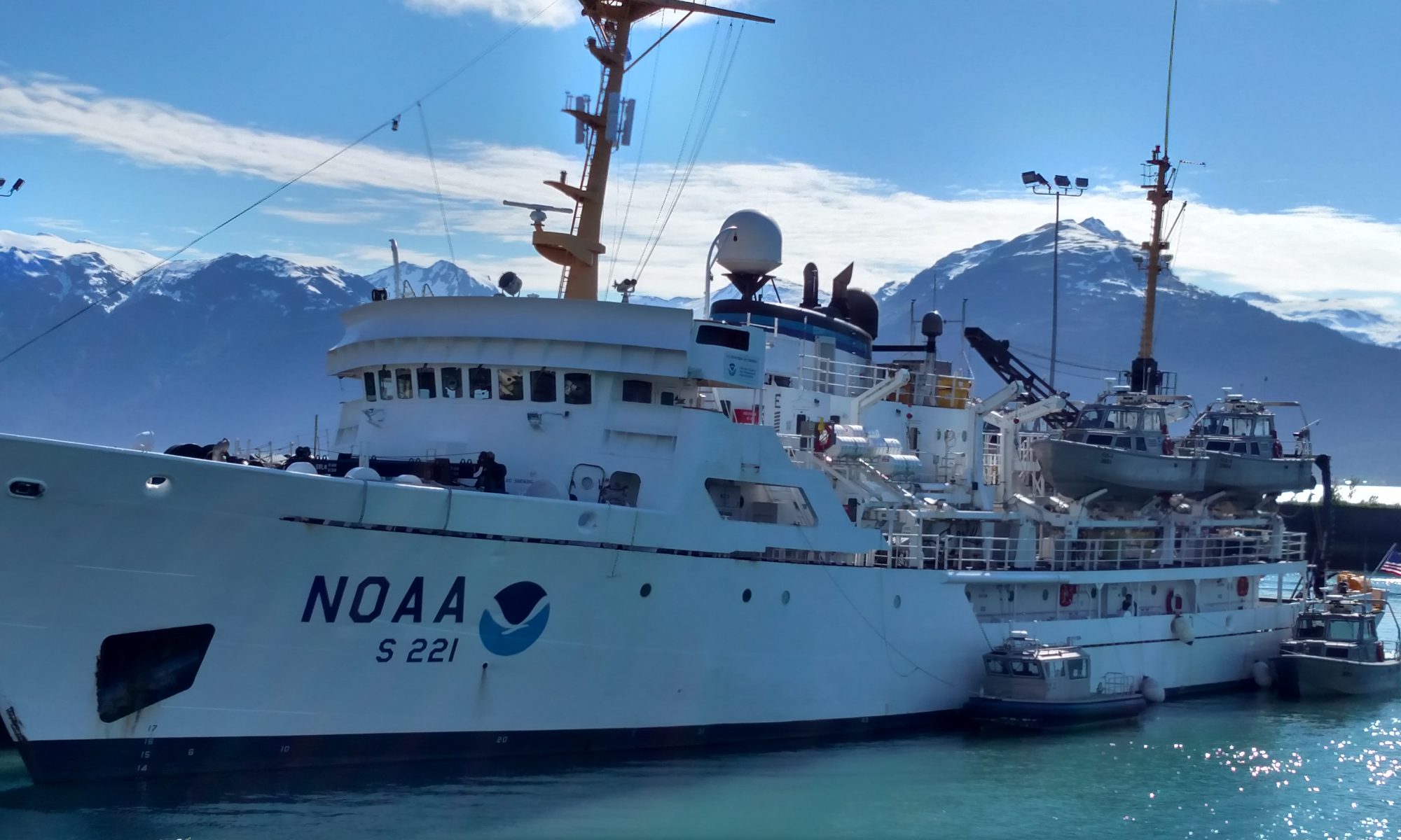
Jeff Lawrence, June 1, 2006

NOAA Teacher at Sea
Jeff Lawrence
Onboard Research Vessel Rainier
May 22 – June 2, 2006

Mission: Hydrography survey
Geographical area of cruise: Alaska
Date: June 1, 2006

Alaskan beauty, Humpback Whale in the distance

Weather data from bridge
Visibility: 8.0 miles
Wind direction: 0 deg. (N)
Wind Speed:  calm winds
Sea level pressure: 1019 mb
Present weather: light sprinkles, partly sunny, calm seas
Temperature:  51 deg. wet/dry 52 deg.

Science and Technology Log 

Alaska has to be one of the most beautiful places on the Earth.  Add to this working aboard a beautiful ship like the RAINIER with a wonderful crew and it equals a really good time.  I saw a variety of wildlife I never thought I would see up close and personal.  I also learned so much about hydrography.  Before this trip I didn’t know the term even existed.

Beautiful sunsets aboard RAINIER!

NOAA provides a wealth of data and information for the general public, private industries, and scientists all over the world.  The trip aboard the RAINIER is a lifetime experience that I will cherish and remember.  Any teachers reading this log who have thought about applying for the Teacher at Sea Program ,but for some reason haven’t done so yet, need to apply NOW!  If you like to learn new things, meet interesting people, see fascinating wildlife, and see extraordinarily beautiful scenery, than a trip aboard the RAINIER is your ticket. The staff at NOAA, take care of all the travel arrangements— all you have to do is be at the airport on time. I have had the best time of my life.  I have been to teacher camps, workshops, and conventions all around the country, but none compare to my time aboard the RAINIER.

XO of the RAINIER: Julia Neander

Captain Guy Noll and XO Julia Neander have gone out of their way to ensure that I was involved in the activities aboard the ship and a part of the crew.  The crew on board the RAINIER, are very helpful and all of them have made my stay at sea a pleasurable experience. I hope I have the opportunity to partake in this program again.  Thanks again to the crew of the RAINIER and the staff at NOAA for taking care of everything.  In the 19 years I have been teaching this has been one of the most rewarding and exciting opportunities of my career.  If you are a teacher thinking about the Teacher at Sea Program, wait no longer, apply today! 

Personal Log 

Captain of the RAINIER: Guy Noll

Terrific, outstanding, excellent, a perfect 10 on the rating scale of what an exciting teacher learning experience should be.  I can’t wait for school to start to share this trip with my students.  Developing lessons that correlate with my experience should be quite easy due to the wealth of information I attained from the crew of the NOAA ship RAINIER. Today I helped them take bottom samples from around the area.

Question of the Day 

FOR TEACHERS:  How do I apply for the Teacher at Sea Program? ANSWER: go here.

Erin Campbell-Survey Tech
Carl Verplank-Seaman Surveyor
This could be you working aboard a NOAA science research vessel.

Jeff Lawrence, May 31, 2006

NOAA Teacher at Sea
Jeff Lawrence
Onboard NOAA Ship Rainier
May 22 – June 2, 2006

Mission: Hydrography survey
Geographical area of cruise: Alaska
Date: May 31, 2006

Weather Data from Bridge as of 0730 Hours
Visibility: 10.0 miles
Wind direction: 340 deg. (NNW)
Wind Speed:  1 knot, light winds
Sea level pressure: 1014
Present weather: mostly cloudy, cool outside, calm seas
Temperature:  49 deg. wet/dry 50.0 deg.

One of the RAINIER’s boat launches going off  on a beautiful day in SE Alaska.
One of the RAINIER’s boat launches going off on a beautiful day in SE Alaska.

Science and Technology Log 

Today I was invited to ride along to Sitka to pick up four crew members and the mail.  The day was beautiful and the boat ride was terrific.  Sitka has been a part of Alaskan history for a long time. The Russians were the 1st Europeans to settle at Sitka.  It was also where Russia turned over Alaska to the U.S. after the purchase by Secretary of State Seward. It was an early capital of Alaska before moving to Juneau. The harbor and city were spectacular, off in the distant background was Mt. Edgecumbe.

Three of the crew we picked up will be returning to the RAINIER after leave. The other passenger has just finished NOAA Corps officer basic training and will be boarding the RAINIER for the first time.  ENS Tim Smith will begin his career with NOAA aboard the RAINIER. Tim is a native of Rhode Island.

Russian Orthodox Church in Sitka

Personal Log 

Today was a spectacular day in SE Alaska full of warm sunshine, calm winds, and calm water. Later in the day it began to cloud up but the winds remained calm.  On the way to Sitka I was able to observe dozens of sea otter, a sea lion, and a porpoise.  Sitka looks like a picturesque town and popular tourist location for large cruise ships.  There was a large cruise ship in the bay when we arrived.  The surrounding mountains and the backdrop of Mt. Edgecumbe makes for beautiful landscape photos.

Questions of the Day 

How many ships are in the NOAA fleet? What is the name of the 2 ships that do hydrography in Alaska? Approximately how many glaciers does Alaska have? What is the capital of Alaska? What is the capital’s latitude and longitude? When did Alaska become a state?

Ceremonial Tlingit Canoe
After a dip at the Hot Springs, back to the  RAINIER paddling a kayak in calm waters.
After a dip at the Hot Springs, back to the RAINIER paddling a kayak in calm waters.

Jeff Lawrence, May 30, 2006

NOAA Teacher at Sea
Jeff Lawrence
Onboard NOAA Ship Rainier
May 22 – June 2, 2006

Mission: Hydrography survey
Geographical area of cruise: Alaska
Date: May 30, 2006

AB Leslie Abramson & Chief Steve Foye  piloting the ship
AB Leslie Abramson & Chief Steve Foye piloting the ship

Weather Data from Bridge as of 0730 Hours: 
Visibility: 10.0m miles
Wind direction: 350 deg. (N)
Wind Speed:  2 knots
Sea level pressure: 1018
Present weather: Scattered cirrocumulus clouds, sun shining brilliantly – It’s a beautiful morning in SE Alaska.
Temperature:  49 deg. wet/dry 50 deg.

Science and Technology Log 

Earlier this week I went out on launch RA 6 to run some lines off Biorka Island.  The weather was a little dreary and cold but made much warmer by the crew, which consisted of Chief Boatswain Steve Foye, AB (Able Body Seaman) Leslie Abramson, and LTJG (Lieutenant Junior Grade) Nicola Samuelson.

LTJG Nicola Samuelson collecting sonar data aboard RA 6

Seas were a little rough running between 4 and 6-foot swells, but the crew did an excellent job staying on their lines and completing the task assigned. Conditions are not always ideal, yet the job must still be done.  If seas are too rough the crew will head to a bay or protected area that still needs to be worked.  Steering a boat in rough sea conditions isn’t easy.  Chief Foye was on board to assist AB Abramson if needed.  Leslie did an excellent job controlling the boat while down below LTJG Samuelson was collecting the data from the sonar.  LTJG Samuelson has finished her 2-year assignment with the RAINIER and will be heading to Rhode Island for her next duty station when we reach our next port stop of Juneau.

Personal Log 

This day was an interesting one. I learned when you feel nausea or seasickness it is better to eat something even though you don’t fell like doing so at the time.  I really enjoyed learning so much about the day-to-day data collection techniques used by the crew of the RAINIER. The equipment is quite sophisticated and the people using it are very well trained. LTJG Samuelson was very helpful in explaining how the data is collected, stored, retrieved, and used to make the nautical navigation charts that NOAA publishes.  The boatswain crews are well trained and do a good job piloting the launch boats through strong tide currents, rocky coastlines, and even rough seas.

Questions of the Day 

How deep is a fathom?

When a ship anchors there are red, white, and blue chain links to show how deep the anchor is. What is the length between these colors called?

How long is this length of chain?

How much does one anchor on the RAINIER weigh?

How much does one marked length of chain weigh on the RAINIER?

What is the keel of a ship?

What is meant when people are talking about a ship or boats draft?

What does it mean when a ships bell rings continuously for 5-6 seconds every minute when it is anchored in open water?

Thanks to Ordinary Seaman Megan Guberski for helping me to pose and answer some of these questions.

Jeff Lawrence, May 29, 2006

NOAA Teacher at Sea
Jeff Lawrence
Onboard NOAA Ship Rainier
May 22 – June 2, 2006

Mission: Hydrography survey
Geographical area of cruise: Alaska
Date: May 29, 2006

Laurel Jennings & Tonya Watson Nick Gianoutsos
Laurel Jennings & Tonya Watson

Weather Data from Bridge
Visibility: 10.0 miles
Wind direction: 290 deg. (WNW)
Wind Speed:  calm
Sea level pressure: 1016
Present weather: scattered to mostly cloudy skies, calm winds
Temperature: 48 de. wet/dry 50 deg.

Science and Technology Log 

Today I visited the plot room.  It is always a busy place.  After the data has come in from the launch boats which have run the lines they were assigned for that day, the data is then downloaded to computers for processing so that accurate navigation charts can be made.  Nick Gianoutsos and Shawn Gonzales both showed me how they clean up the data so it can be processed to make charts of the bottom of the channels, narrows, and waterways used by navigators throughout Alaska. The final product must both be accurate and reliable so that ships can trust the charts they are reading and using to plot navigation points and travel safely through hazardous coastal areas.

 Nick Gianoutsos
Nick Gianoutsos

Wrangell Narrows is where the data has been being collected from for the past couple of weeks. Wrangell Narrows extends almost 21 miles from the Sumner Strait to the south up to Frederick Sound to the north, near Petersburg, Alaska.  The channel is very narrow in places, with dangerous ledges and strong tidal currents, and can be a treacherous waterway for larger boats if not marked and navigated properly.  Cruise ships, Alaska State Ferries, tugs and barges, freight boats, pleasure boats, and commercial fishing boats navigate the channel. Some of the cargo that travels through the Narrows includes: lumber products, fish products, petroleum products, provisions, and general cargo.  There are no roads to Petersburg, so everything has to come by boat or plane. The narrows can be a busy place for traffic in this area of Alaska.  All known dangers in the Narrows are charted and most are marked.  The mean range of the tide is 13.4 feet and diurnal range is 15.7 feet at Petersburg.

Shawn Gonzales & Nick Gianoutsos

Members of the crew aboard the NOAA ship RAINIER are entering and analyzing data from the survey lines run from the launch boats during the day.  This data will give an accurate indication of what lies below the water and also what lies above it.  The crew aboard RAINIER keeps working, long after regular work hours are over. Crunching the numbers from a launch into useable data for charts for navigation.  

Personal Log 

Today I was privileged to see a part of Alaska, Biorka Island, which is northwest of where we were near Petersburg in the Wrangell Narrows.  The change of scenery was exciting and nearby are hot springs which are very warm and relaxing according to some of the crew who spent time there after hours.

Question of the Day 

Using the information from log #4, which was Thursday’s log, how long will it take a ship that travels at 15 knots per hour to transit 231 miles?

Chief Survey Technician: Jim Jacobson

Jeff Lawrence, May 28, 2006

NOAA Teacher at Sea
Jeff Lawrence
Onboard NOAA Ship Rainier
May 22 – June 2, 2006

Mission: Hydrography survey
Geographical area of cruise: Alaska
Date: May 28, 2006

Weather Data from Bridge
Visibility: 7.0 miles
Wind direction: 210 deg.  SSW
Wind Speed:  8 knots
Sea level pressure: 1006 mb
Present weather: overcast with light rain
Temperature:  48 deg. wet/dry 48 deg.

Mt. Edgecumbe Volcano near Biorka Island

Science and Technology Log 

Today is the first full day at Biorka Island, the ship anchored here yesterday afternoon.  In the background is Mt. Edgecumbe a volcano on Kruzof Island.  On the journey from the Wrangell Narrows we encountered some small swells but overall a smooth trip. It takes many parts to make a whole when it comes to keeping a ship the size of RAINIER running.  Engineers and Stewards are the people aboard RAINIER who keep the ship moving.  The engineers work about the ship fixing any problems that arise, do general maintenance, and keep the RAINIER in ship shape condition.  There are 4 stewards aboard the RAINIER and have the most important job, which is feeding the crew of the RAINIER. To keep up moral on a ship it is important to feed the crew quality meals that satisfy their appetites after a busy day at sea.  The stewards aboard the Rainier are:

  • Chief Steward: Sergio Taguba
  • Chief Cook: Doretha Mackey
  • 2nd Cook: Floyd Pounds
  • 2nd Cook: Raul Quiros

The same day I flew into Petersburg and boarded RAINIER Milton Ellison from Michigan arrived to begin his new job as a general vessel assistant (GVA).  He has spent 8 years in the Navy and several more years in the civilian workforce. Milton has signed on to finish up retirement with NOAA.  There are ten crews members aboard the RAINIER that make up Electronics and Engineering departments.  NOAA provides many opportunities for those eager to experience new adventures.

The stewards always have a good variety of delicious food.

Personal Log 

Crew member GVA Milton Ellison doing  ship maintenance on the RAINIER.
GVA Milton Ellison doing ship maintenance

We are anchored in Hot Springs Bay, another beautiful view of the Alaskan coastline. Mt. Edgecumbe is in the distant background giving spectacular panoramic views of the area. The crew was able to visit the hot springs in the area last night.  Today we will run lines around Biorka Island in the launch boats.

Questions of the Day 

What is the name of the large volcano on an Island just to the northwest of Biorka Island near Sitka? Is the volcano active or dormant? How high is the volcano in elevation (ft.)? What is the latitude and longitude of this volcano? What is the highest peak volcano in Washington State? How high is it? What ship in the NOAA fleet is named after it?