Kate Schafer: So Many Snappers… September 24, 2017

NOAA Teacher at Sea

Kate Schafer

Aboard NOAA Ship Oregon II

September 17 – 30, 2017


Mission: Shark/Red Snapper Longline Survey

Geographic Area of Cruise: Gulf of Mexico

Date: September 24, 2017

Weather Data from the Bridge:

Latitude: 28o 25.1’ N
Longitude: 94o 50.3’ W

Broken sky

Visibility 10 nautical miles

Wind speed 13 knots

Sea wave height 2-3 feet

Temperature Seawater 28.8 o Celsius

Science and Technology Log:

This is a shark and red snapper longline survey, and the sharks tend to steal the stage.  They are bigger (for the most part), more diverse and definitely have more of a reputation.  I have been surprised, however, by how much I’ve been drawn to the snappers.  They are a beautiful color, and tend to come up in groups that are pretty similar in size.

RedSnapper
Red snapper (Lutjanus campechanus) ready to be measured

The Northern Red Snapper (Lutjanus campechanus) is commonly fished in the Gulf of Mexico, both recreationally and commercially.  It turns out that the commercial fishers get 51% of the catch quota and the recreational fishers get 49%.  The methods for dividing up those two basically equal pieces of the pie is different between the commercial and recreational fishers. In addition, the commercial fishing catch is monitored very closely, while the recreational fishing catch numbers are largely unknown.  Plus, the states have their own waters that extend out to different distances, depending on the state, and the federal waters extend from the state water boundary to 200 nautical miles offshore.  So, in other words, managing the fishery is quite complicated.

So, how do all these fishing rules and regulations get established and modified over time?  A law was passed in 1976, called the Magnuson-Stevens Fishery Conservation and Management Act, and one of the key parts of the act established eight regional management councils for regulating fishing in federal waters (more information on the act here: http://www.nmfs.noaa.gov/sfa/laws_policies/msa/).  It also established the 200 nautical mile extension of federal waters from land.  The Gulf of Mexico Fishery Management Council (GMFMC) is responsible for creating Fisheries Management Plans (FMPs) for fisheries within the U.S. federal waters of the Gulf of Mexico, from southern Texas, along Louisiana, Mississippi, and Alabama, and down the west coast of Florida.  This graphic shows the catch limits for red snapper and other species for 2017 set by the GMFMC.  For red snapper, the catch limit is close to 14 million pounds.

2017ACLBLOGGraphic_07-17-1024x663
Annual Catch Limits as set by the Gulf of Mexico Fishery Management Council (http://gulfcouncil.org/fishing-regulations/federal/)

The data that we are collecting helps scientists and policy makers to determine what the annual catch limit for a particular season should be.  For each fish that we bring on board, we measure the fish length and weight, as well as the weight of the gonads.  In addition, we collect their otoliths (ear bones) and samples of the ovaries of females.  These both help managers to estimate the age and size of the population, and future populations as well.

Otoliths are calcium carbonate hardened structures and are present in the part of the inner ear that is responsible for balance.  Humans and other vertebrates have them too, and they can be used to tell the age of the fish.  The otoliths of Lutjanus campechanus are quite large.  There seems to be an overall relationship between the habitat of the fish species and the size of the otolith.  Species like Lutjanus campechanus that live along reefs and rocky structures have much larger otoliths than species like tuna that swim up in the water column.  Flying fish, which we’ve seen a lot of, also have large otoliths, given their body size, probably aiding them in knowing where they are as they glide through the air.

Otoliths
Otoliths taken from one of the red snappers we collected

Well, we have been collecting a lot of data over the past couple of days to help inform these policies in the future!  Each line we’ve pulled in lately has had a dozen or more snappers on it,  and they are a lot of extra work as compared with the sharks, due to all the samples we have to collect once we’re done.  A couple times, we’ve barely finished before it was time to start baiting lines again.

Personal Log:

As I mentioned earlier, I’ve really come to love the red snappers.  Their eyes are the same color as their skin and I’m just awed by their size.  I am used to snappers that I’ve watched on coral reefs, and even the largest species I’ve seen on reefs are nothing compared with these guys.

SnapperEye
Red snapper (Lutjanus campechanus) eyes

I’ve also adjusted to the shift in my day, as evidenced by the fact that I’m finishing this up at 1 a.m.  It has been a long time since I’ve been on this kind of late night schedule.  I’m enjoying it, especially because I know when I return to California, I’ll be getting up at 5:30 a.m. again.


Did You Know?

That snappers eat a wide variety of different foods, including fish and various types of crustaceans? Here are a couple of items we’ve found in the ones we’ve caught.  Can anyone identify them?  I studied the second group for my Ph.D. dissertation!

MoleCrab
Mystery snapper food
Stomatopod
More snapper food


And We’re Fishing…

NOAA Teacher at Sea

Kate Schafer

Aboard NOAA Ship Oregon II

September 17 – 30, 2017


Mission: Shark/Red Snapper Longline Survey

Geographic Area of Cruise: Gulf of Mexico

Date: September 21, 2017


Weather Data from the Bridge:

Latitude: 27o 15.5’ N

Longitude: 97o 01.3’ W

Haze

Visibility 6 nautical miles

Wind SE 15 knots

Sea wave height 3-4 feet

Sea Temperature: 29.6o Celsius

Note: Just a month ago Hurricane Harvey was bringing 20 foot seas to this area, but today we’re enjoying the 3-4 foot swell.

Science and Technology Log:

Well, we’ve gotten to the fishing grounds, and we’ve gone from waiting to very busy!  We put out the first lines starting at around 8 pm on Tuesday evening.  The process involves first baiting 100 hooks with Atlantic mackerel.  When it’s time for the line to be deployed, first there is a tall buoy with a light and radar beacon (called a high flyer) on it that gets set into the water, attached to the monofilament fishing line.  Then there’s a weight, so the line sinks to the bottom, a series of 50 baited hooks then get clipped onto the line as the monofilament is being fed out.

Those 50 hooks are referred to as a “skate”.  This confused me last night when I was logging our progress on the computer.  I kept thinking that there was going to be some kind of flat, triangular shaped object clipped on to help the line move through the water…not really sure what I was imagining.  Anyway, Lisa Jones, the field party chief and fisheries biologist extraordinaire, has so kindly humored all my questions and explained that skate is just a term for some set unit of baited hooks.  In this case, the unit is 50, and we’ll be deploying two skates each time.

After the first skate comes another weight, the second skate, another weight and then the last high flyer.  Then the line is set loose and we wait.  It’s easy to locate the line again, even at night, because of the radar beacons on the high flyers.

Why are we collecting this data?

As mentioned in my previous post, one of the tasks of NOAA, especially the National Marine Fisheries Service Line Office, is to collect data that will help with effective fisheries management and assist with setting things like catch quotas and so forth.  A catch quota refers to the amount of a particular species that can be harvested in a particular year.  Fisheries management is incredibly complicated, but the basic idea is that you don’t want to use up the resource faster than it is replenishing itself.  In order to know if you are succeeding in this regard, you must go out and take a look at how things are going.  Therefore, the Oregon II goes out each year in the fall and samples roughly 200 sites over about eight weeks.  The precise locations of the sampling sites change each year but are spread out along the SE Atlantic Coast and throughout the U.S. waters in the Gulf of Mexico.

We’ve put out three long lines so far.  Last night, we caught a single fish, but it was a really cool one.  It’s called the Golden Tilefish but has an even better species name: Lopholatilus chamealeonticeps.  As Lisa was explaining that they dig burrows in the sea floor, I realized that I had seen their cousins while snorkeling around coral reefs but would never have made the connection that they were related. This guy was big!


Tilefishp3
Golden tilefish (Lopholatilus chamealeonticeps) caught in first longline of the trip

This afternoon, things got really hectic.  Of our 100 hooks, 67 had a fish on it, and 60 of those were sharks.  As we were pulling in the last bit of line, we pull on a shark that was missing its back half!  Another had a bite taken out of it.  And then on hook number 100, was a bull shark.  This shark had been snacking along the line and got caught in the process.

OLYMPUS DIGITAL CAMERA
Bull shark caught on the last hook of a very productive bout of fishing (Photo courtesy of Lisa Jones, NOAA)

And I haven’t even mentioned the red snappers.  I will save them for another post, but they are absolutely beautiful creatures.

MeasuringSnapperp3
Red snapper being measured


Personal Log:

I definitely continue to feel out of my element at times, especially as we were pulling in all these hooks with sharks on them, and I could barely keep up with my little job of tracking when a fish came on the boat.  All the sharks started running together in my mind, and it was definitely a bit stressful.  Overall, I feel like I’ve adjusted to the cadence of the boat rocking and have been sleeping a lot more soundly.  I continue to marvel at how amazing it is that we’re relatively close to shore but, except for a few songbirds desperate for a rest, there is no evidence of land that my untrained eyes can detect.  Lastly, I’ve realized that a 12-hour sampling shift is long.  I have a lot of respect for the scientists and crew that do this for months on end each year with just a few days break every now and then. Well, it time to pull in another line.  Next time, we’ll talk snapper.


Kate Schafer: Setting off for Brownsville, TX, September 18, 2017

NOAA Teacher at Sea

Kate Schafer

Aboard NOAA Ship Oregon II

September 17 – 30, 2017


Mission: Shark/Red Snapper Longline Survey

Geographic Area of Cruise: Gulf of Mexico

Date: September 18, 2017


Weather Data from the Bridge:

Latitude: 27o 02.5’ N
Longitude: 94o 32.6’ W

Scattered clouds

Visibility 14 nautical miles

Wind speed 10 knots

Sea wave height 1 foot

Temperature Seawater 29.9 o Celsius


Personal log

Sunday afternoon, September 17

I arrived in Pascagoula, Mississippi in the late afternoon on Saturday after a long day of travel.  Things were so quiet on the ship that evening as most of the crew had gone home during the break between legs of the survey.  It was great to be met and shown around by a friendly face, the Officer on Duty (OOD) David Reymore.  I definitely was feeling a bit like a fish out of water, even though we hadn’t even left the dock yet. As people start to arrive back on the ship, they all know their role and are busy getting ready for our departure later on today. It’s a good experience to feel like you’re out of your element every now and again and I guess a small part of why I decided to apply for a Teacher at Sea position in the first place.

NOAA

As I was preparing to depart on this adventure and was explaining that I was going to be a NOAA Teacher at Sea, I had a number of people ask me what NOAA stood for, so I thought I’d provide a bit of information about what they are and what they do.  First, NOAA stands for the National Oceanic and Atmospheric Administration, and the name definitely suggests the broad mission that the agency has.  Their mission involves striving to understand the oceans, atmosphere, climate, coastlines and weather and making predictions about how the interactions between these different entities might change over time.

That is a tall order, and the agency is divided up into different offices that focus on different aspects of their mission.  The National Weather Service, for example, is focused on forecasting the weather and makes predictions about things like where hurricanes will travel and how intense they will be when they get there.  The National Marine Fisheries Service is tasked with studying the ocean resources and habitats in U.S. waters and to use that understanding to create sustainable fisheries.

So far, I’ve met many people that I’ll be sharing the boat with over the next two weeks.  They have all taken time to introduce themselves and talk for a bit, even though I know that they’ve got tons to do before we sail.

Sunday evening

Well, we’re underway towards our first sampling sites off the coast of Brownsville, Texas.  The seas are really calm, and I’m sitting up on the deck enjoying the light breeze and digesting the delicious dinner of jambalaya, vegetables and blackberry cobbler.  On our way out from Pascagoula, we saw a few dolphins, beautiful white sand barrier islands and mile after mile of moon jellies, but now we’re no longer in sight of land.

P1030600
Barrier island off the coast of Mississippi

We’ve passed an occasional oil rig off in the distance but haven’t seen much else.  The sun just set behind just enough clouds to make the colors spectacular and then as I was climbing down the stairs, I saw a handful of dolphins playing in the boat’s wake.

IMG_3919
Sunset over the Gulf of Mexico

Monday, September 18

Today will be a full day of travel to reach our fishing grounds.  Assuming we continue to make steady progress, we should arrive in the late afternoon or early evening on Tuesday to begin fishing.  We will be baiting 100 hooks that, once deployed, will remain in the water for an hour before we pull them back in.  We’ll be fishing in a variety of depths while working our way back towards Pascagoula.  We practiced some drills this afternoon, including a “man overboard” simulation, using a couple of orange buoys.  They deployed a rescue boat and had retrieved the buoys in a matter of minutes.  I have to admit that watching them get out there with such speed and skill put me at ease.

IMG_3927
Rescue boat deployed during the “man overboard” drill


Kate Schafer: Off to the Gulf, September 16, 2017

NOAA Teacher at Sea

Kate Schafer

Aboard NOAA Ship Oregon II

September 17 – 30, 2017

Mission: Shark/Red Snapper Longline Survey

Geographic Area of Cruise: Gulf of Mexico

Date: September 16, 2017

Introduction

Welcome to my Teacher at Sea blog!  My name is Kate Schafer, and I am a teacher at the Upper School at the Harker School in San Jose, California, right in the middle of Silicon Valley.  I teach biology, marine biology and food science to mostly juniors and seniors.  This may seem like an odd mix of courses, but I am so fortunate to be able to teach students about all my favorite topics.  I have heard that the food is delicious on the Oregon II, and I’m interested in learning more about the challenges of keeping a crew fed when you can’t pop down to the corner grocery store when you realize that you forgot to order that crucial ingredient.  I have spent many hours on the ocean, and spent six years studying coral reefs in Belize, Central America, but I’ve never been to sea on a research vessel.  I’m thrilled to have that opportunity and to share it with my students.

My husband, daughter and I ready to tour the Atlantis in Woods Hole, MA this summer

Weather Data

The weather has been a big topic of conversation of late here in San Jose.  Two weekends ago set all-time record high temperatures throughout the Bay Area, even along the coast.  Living in close proximity to the ocean, we expect relief from that rare hot day to come rather quickly, but the heat lingered for days.  We’re back to normal fall weather as I head off, though.  This morning is cool and seasonable.  I know from growing up in Atlanta, Georgia, that I’m heading to warm and humid conditions on the other end of my travels.

Science and Technology Log

On this research cruise, we will be conducting long line surveys, looking at shark and red snapper populations in the Gulf of Mexico.  I will report more on where we are going and what we’re studying once the leg of the survey begins. There are multiple legs to the survey, and I’ll be joining in for the fourth and final leg.  It has been a tumultuous time in the Gulf over the past few weeks, and it will be interesting to learn about how this has impacted the coastal waters in the area we will be surveying.

Personal Log

I am sitting in the airport in San Jose, ready to board my flight to Dallas, en route to Gulfport and my final destination of Pascagoula, Mississippi.  Wow! It’s been a frantic week of getting all sorts of last minute pieces put together to allow things to, hopefully, run smoothly in my absence.  It’s early morning, so I’m still in a bit of a groggy cloud, making the fact that I’m actually heading off on this adventure all the more unreal.

Even the grogginess cannot stifle my excitement, though, as I head off for two weeks of working with scientists and collecting data.  As I was packing last night, I couldn’t help but be reminded of all the previous trips I packed for more than 15 years ago to conduct field research on coral reefs in Belize.  I was studying a type of crustacean called the stomatopod and learning about the role that they play in coral reef ecosystems, how they interact with other species like pygmy octopus and crabs, their main source of prey.

I am thrilled to be heading out on this research trip and feel so fortunate for the opportunity.  I look forward to questions from you about what we are doing and learning on our voyage.  Check in frequently for updated blog posts once the trip commences.

Did You Know?

That the Oregon II has been part of the NOAA fleet since 1977?

Susan Brown: Who Needs Sharks Anyway? September 13, 2017


NOAA Teacher at Sea

Susan Brown

Aboard NOAA Ship Oregon II

September 3 – 15, 2017


Mission: Snapper/Longline Shark Survey

Geographic Area of Cruise: Gulf of Mexico

Date: September 13, 2017

IMG_6406
sunset through jaws of a blacktip shark


Science and Technology Log

We have been sampling along the coast of Florida, Alabama, Mississippi, Louisiana, and Texas at varying depths – “A” stations ( 5- 30 fathoms), “B” stations (30 -100 fathoms) and “C” stations (100 – 200 fathoms). A fathom is six feet or approximately 2 meters. The longlines are baited the same – mackerel on 100 hooks spread out across one nautical mile and then set on the bottom of the ocean. As we reel in the long line, the click and whine of the line as it’s being spooled, we wait in anticipation of what it may bring. Each station yields something different and you never know what you are going to get. Below is a list of some of the animals we have encountered.


IMG_6286
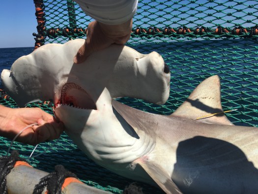
baby hammerhead

Shark species: blacktip, sharpnose, blacknose, scalloped hammerhead, great hammerhead, bull, tiger, spinner and bonnet head (to learn more about each of these species, select it for a NOAA fact sheet).

IMG_6273.jpg
Scallop Hammerhead in cradle

Other animals: southern ray, cownose ray, roughtail stingray, red snapper, black drum, sharksuckers, catfish, red drum, yellowedge grouper, king snake eels and even some blue crabs.

So why survey sharks? Did you know that people are one of only a few species that prey on sharks — killer whales and other sharks are the others– killing over a hundred million per year?* Sharks are apex or top predators in an ocean food web and play a vital role in keeping this food web in balance. With the hunting of sharks as well as over fishing the prey that sharks eat we are disturbing the natural balance. This survey is used determine the number of sharks and other species that are present in the Atlantic Ocean including the Caribbean Sea and the Gulf of Mexico. With these numbers, the National Marine Fisheries Service (NOAA Fisheries) regulate how many sharks, swordfish and tuna can be harvested without impacting the total population. In the Pacific Ocean, NOAA fisheries work with fisheries in developing how to best manage sharks.

IMG_6731
red snapper

Apex predators in any ecosystem are vital to the health of that ecosystem. These top predators keep numbers down on the more abundant prey species and keep their numbers in check. Here is a simplified illustration of what happens when we lose apex (top) predators in an ocean ecosystem.

If the number of sharks goes down then the food the sharks eat goes up (forage fish) because they are not being eaten by the sharks. With more of those forage fish around their need for food – the zooplankton – increase. With more forage fish eating the zooplankton there are less zooplankton and their numbers begin to decrease. If there are less zooplankton then the phytoplankton numbers increase because the zooplankton aren’t around the eat them. Removing top predators from any ecosystem can have an impact on the entire food web and this phenomena is called a trophic cascade.

IMG_6489
Removing Hook

Personal Log

When people think of sharks, they think of the movie Jaws. Unfortunately this has given sharks a bad reputation and has vilified these animals that are essential to the ocean food webs. Sure, there have been shark attacks, but did you know that more people are killed each year by electrocution by Christmas tree lights than by shark attacks? When people imagine sharks, they think of enormous sharks that eat everything in sight. The reality is that sharks come in all sizes and shapes. A mature Atlantic sharpnose shark will only get to be 3.5 feet long with the world’s smallest shark being the dwarf lantern shark that can fit in the palm of your hand. The largest shark is the harmless-to-human whale sharks that feeds primarily on plankton and can grow up to 60 feet!

IMG_6084
Smooth-hound (Mustelus Sinusmexicalis)

Did You Know?

Scientists can tell the age of a shark by counting the rings on its vertebrae (similar to how they can tell how old a tree is by counting its rings!)

Question of the day:

What is an example of a terrestrial (land) apex predator that has been over hunted impacting the entire ecosystem?

hint: watch this video clip: https://www.youtube.com/watch?v=ysa5OBhXz-Q