Vincent Colombo, What makes the Oscar Dyson tick?, June 29, 2015

NOAA Teacher at Sea
Vincent Colombo
Aboard NOAA Ship Oscar Dyson
June 11 – 30, 2015

Mission: Annual Walleye Pollock Survey
Geographical area of the cruise: The Gulf of Alaska
Date: June 29, 2015

Weather Data from the Bridge:

  • Wind Speed: 10.7 knots
  • Sea Temperature: 9.6 degrees Celsius
  • Air Temperature: 10.5 degrees Celsius
  • Air Pressure: 1008.8 mb
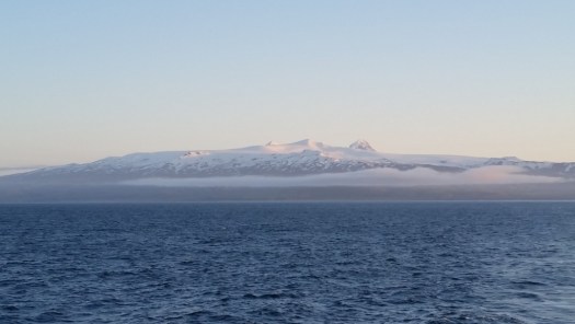
Sunrise in Alaska
Sunrise in Alaska
When the fog lifts, hidden beauties and dangers are revealed
Another picture of Shishaldin Volcano – taken by scientist on board the Oscar Dyson, Robert Levine
A view of the Gulf of Alaska
In front of Kuiukta Bay
Mitrofania Bay
Mitrofania Bay
Sandy Point, Alaska
Sandy Point, Alaska

The NOAA Vessel Oscar Dyson is named after the late Oscar E. Dyson. His placard reads the following:

Oscar Dyson

A Friend of Fisheries

Oscar promoted research and effective management

to sustain Alaska’s fisheries for future generations.

Oscar Dyson Plaque
Oscar Dyson Plaque
http://www.noaanews.noaa.gov/stories2003/s2102.htm
Learn more about the Oscar Dyson here
The small vessel on the Oscar Dyson is named after his wife

Science and Technology Log:

If you read the link under my page: http://teacheratsea.noaa.gov/#/2015/Vincent*Colombo/ship , it will tell you all about the ship, Oscar Dyson. This ship is nothing less than a modern marvel of technology. Luckily my fellow teacher at sea, Nikki Durkan and I got to experience the science of this ship first hand. Our Chief engineer, Mr. Alan Bennett took us for a tour of the inner workings of this ship.

Chief Engineer Alan Bennett

Our tour started with a look at the Ship’s control panel. From this set of computers and controls, everything, and I mean everything on the ship can be controlled.

The Control Panel below deck
"We can control the entire ship from right here."
“We can control the entire ship from right here.”

From there, we went into the main engine room. One may recognize the Rime of the Ancient Mariner by Samuel Taylor Coleridge, which in part of the poem says:

“Water, water, everywhere,

And all the boards did shrink;

Water, water, everywhere,

Nor any drop to drink.”

Not the case on the Oscar Dyson, because the heat from the engines is used to distill up to 1,000 gallons of freshwater each day!

Where the Oscar Dyson makes fresh water

The ship also uses an Ultra Violet filter to kill all the undesirables in the water just in case.

Ultraviolet Filter
Ultraviolet Filter
Warning for the filter

From there, we got to travel through water tight doors into the rear of the ship. These doors are intimidating, and as our Chief Engineer said, in case there is a loss of power, the door can be bypassed so no one is trapped under the ship.

Alan in front of the door showing us the manual bypass
Water tight door. You DO NOT want to be in the way when this closes.

Here you can see one of the massive winches used for the trawl net the ship uses to catch fish. One winch is over 6 foot in diameter and has a thousand meters of steel cable. I wonder if it will fit on the front of a Jeep…

Those winches are no joke. The ship also has a bunch of hydraulic pumps ready and able to bring those trawl nets in fast if need be. Each of these hydraulic pumps has 1,000 gallons of fluid ready to retrieve a net in a hurry if the need exists.

The hydraulic pumps
The hydraulic pumps

One really cool thing I learned was that in case the ship had a major issue and could not be steered from the bridge, there is a way to use the ship’s heading underneath for someone to manually operate the rudder.

Yes you can drive the ship blind
The manual rudder control

From there we got a tour of the remainder of the ship.

One of the ship's massive generators
One of the ship’s massive generators
A water pump for a fire station
A transformer to convert all that electrical energy

The Oscar Dyson creates ALOT of energy. Here is a read out for one of the many generators on board. Take a look at the Amps produced.
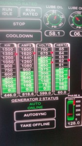
818.6 Amps!
818.6 Amps!

A ship this big also has multiple fuel tanks. Here the engineers can choose which tank they want to draw from. Interesting also is the engineers have ballast tanks to fill with water to compensate for the fuel the ship uses. Alan also showed us the log book for this, as ships taking on ballast water can be an environmental issue. The crew of the Oscar Dyson follows this protocol as set forth by the United States Coast Guard. You can learn more about that protocol by clicking here

Fuel tank selection
Fuel tank selection

Our last stop was seeing the bow thruster. It was a tight space, but the bow thruster can actually power the ship if the main engine loses power.

In the bow thruster room

Here are some other pictures from the tour:

Nikki, Alan, and I in the engine room
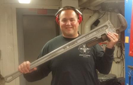
A serious pipe wrench
This surface is squishy and covers the entire engine room. It makes the boat super quiet!


After our tour, it was back to business as usual, the Walleye Pollock Survey. Our Chief Scientist spends countless hours analyzing the acoustics data then sampling the fish.

Our Chief Scientist, Dr. Patrick Ressler analyzing the acoustic data from the survey

The Walleye Pollock which we are studying is a very integral part of the Alaskan ecosystem, as well as a highly monetary yielding fishery. One thing I noticed almost immediately is the color change between juveniles and adults. It is theorized that as the fish get older, they move lower in the water column towards the bottom, thus needing camouflage. Take a look at this picture that shows a mature Walleye Pollock and it’s juvenile counterparts.

The adult Walleye Pollock gets "brassy" spots on it's body.
The adult Walleye Pollock gets “brassy” spots on it’s body.

You can learn more about the life cycle of Pollock by clicking here.

Here is another site with some useful information on Pollock, click here.


Personal Log: 

Working on the deck of the Oscar Dyson is no laughing matter. What is required to step on deck? A hard hat, float coat, and life jacket. Watching the deck crew, controlled by the lead fisherman, is like watching an episode of Deadliest Catch… just without the crabs. Giant swells that make the boat go up and down while maintaining a solid footing on a soaking wet deck is no joke. My hat is off to our hard working deck crew and fisherman.


The deck crew and fisherman deploying an Aleutian Wing Trawl
Fisherman Brad Kutyna retrieving an Aleutian Wing Trawl

The best part about fishing, is it is just that, fishing. NOAA sets the standard when reducing by-catch (fish you do not want to catch), but sometimes a fish’s appetite gets the best of him/her.

This Pacific Cod ended up in our Aleutian Wing Trawl, it wanted Pollock for lunch
These Pacific Cod were 8 pounds each.
These Pacific Cod were 10 pounds each.

Fishing has always been apart of my life. My Grandfather always said, “If the birds are working, you will find the fish.” A good piece of advice… Look for circling gulls and chances are a group of bigger fish has some bait fish balled up under the surface.

Here the birds are working off the stern of the boat


Meet the Scientist: 

On board the Oscar Dyson this part of the Walleye Pollock survey is scientist Tom Weber. Tom lives in Durham, New Hampshire and is here to test new custom acoustic equipment. Tom is married to his wife Brinda and has two sons, Kavi and Sachin.

Tom has a Bachelor’s and Master’s degree in Ocean Engineering from the University of Rhode Island. He attained his PhD in Acoustics from Penn State in State College, PA.  Currently Tom is an Assistant Professor of Mechanical Engineering at the University of New Hampshire. He also is a faculty member of the Center for Coastal and Ocean Mapping (CCOM for short). Both places of employment are located in his hometown of Durham, New Hampshire.

Tom explaining the brand new acoustic technology

Tom has been affiliated with NOAA and their projects since 2006 and is here to test a custom Acoustic Transducer (a piece of technology that sends out a signal to the ocean floor) and sonar transceiver. As he explained to me, this technology sends out a multi-band frequency and the echo which returns could potentially identify a species of fish hundreds of meters below the boat. He is also here to study Methane gas seeps found along the convergent boundary in the Aleutian Islands.  Methane gas seeps are of particular curiosity on this trip because of their unique properties.

Tom busy at work in the Acoustic Lab on board the Oscar Dyson

On a side note, Tom saw the first grizzly bear of our trip just hanging out on one of the many coastlines we have passed. He said being on the Oscar Dyson is “Not like being in Beaver Stadium, but the ship moves as much as your seats do during a game.”  When I asked Tom for any words of advice, he said: “Never name your boat after a bottom fish.” Apparently that is bad luck.

A methane gas seep on the ocean floor makes quite a disturbance. Here Chris Bassett is observing what it looks like.

Tom loves working side by side with the scientists on this study and is ecstatic to see this new technology being used on this survey.


Meet the NOAA Corps Officer: 

Meet Lieutenant Carl Rhodes, the Oscar Dyson’s Operations Officer, and acting Executive Officer for this part of the Walleye Pollock Survey. LT Rhodes is from Bayfield, Colorado and joined the NOAA Corps to use his degree in science. LT Rhodes has a Bachelors degree in Marine Science with an Associates Degree in Small Vessel Operations from Maine Maritime Academy in Castine, Maine. LT Rhodes also has a Masters of Science in Facilities Management from Massachusetts Maritime Academy.

His job as Operations Officer on board the Oscar Dyson includes:

  • Ensuring all scientific operations are conducted safely and efficiently.
  • Act as a liaison between all members of the ship’s crew and scientific parties.
  • Record and observe all scientific missions during the day.

His extra duties as acting executive officer include:

  • Managing the ship’s personnel and human resources
  • Taking care of payroll and travel requests
  • Supervising junior officers and crew members
Lieutenant Carl Rhodes on the bridge of the Oscar Dyson

Hands down, the best job of all not mentioned above is driving the boat! All officers stand watch (aka drive the boat) for two, four hour shifts a day. Not to mention all the other work they are required to do. Being a NOAA Corps officer is no easy job. LT Rhodes has the goal to one day be the Captain of a NOAA research vessel.

In his free time, LT Rhodes enjoys scuba diving, climbing mountains, hiking, camping, biking, photography, and flying drones. LT Rhodes shared with me how he has overcome many obstacles in his life. His words of advice to any student are: “Anyone can get anywhere if they try hard and really fight for it.”

LT Rhodes and all the rest of the crew of the Oscar Dyson have not had a day off yet on this research cruise, and work 12 hour shifts around the clock. Seeing this first hand has given me much respect for the type of work NOAA does!


Did You Know? 

Seafood is a billion dollar industry in Alaska, with more than half of U.S. commercially captured fish caught in the state nicknamed “The Last Frontier.” According to Alaska’s Department of Labor and Workforce, around 32,200 people fished commercially in Alaska in 2011, averaging 8,064 people per month. Salmon harvesting represents half of all fishing jobs in Alaska, with ground fish and halibut following in second and third place, respectively, according to the state’s labor bureau. Read more here.


 Thanks for reading my blogs! I am hooked on Alaska and would love to come back! I will see you all soon in Delaware!

Vincent Colombo, Into the Fog, June 21, 2015

NOAA Teacher at Sea
Vincent Colombo
Aboard NOAA Ship Oscar Dyson
June 11 – 30, 2015

Mission: Annual Walleye Pollock Survey
Geographical area of the cruise: The Gulf of Alaska
Date: June 21, 2015

Weather Data from the Bridge:

  • Wind Speed: 6.02 knots
  • Sea Temperature: 9.99 degrees Celsius
  • Air Temperature: 9.06 degrees Celsius
  • Air Pressure: 1016.59 mb
Unimak Island at sunrise
Unimak Bight
Unimak Bight
Shishaldin Volcano - One of Alaska's many active volcanoes
Shishaldin Volcano – One of Alaska’s many active volcanoes

Science and Technology Log:

You are sleeping soundly in your bed. Awakening you is your phone ringing… it’s 5:30 am… that could only mean one thing, it’s the school calling to say school is delayed 2 hours… FOG. No, it’s not the kind of fog depicted in John Carpenter’s thriller; it’s the kind that the local weatherman says is a localized phenomenon that reduces visibility to less than a quarter mile. If you live on Delmarva, you have experienced this sort of fog and know that it can turn a normal commute into a complicated one.

Here in the Alaskan summer, especially the Aleutian Chain, Gulf of Alaska, and the Bering Sea, fog is a normal, and potentially ALL day event. The only constant on this research cruise so far has been waking up every day and watching our NOAA Corps Officers navigate through a very dense fog.

A view from the bridge of the fog. You can barely see past the bow

But what causes fog, and why is it so prevalent here?

Fog is most simply described as a cloud on the ground. It is made up of condensed water droplets that have encircled some sort of condensation nuclei (something water can attach to). On the open sea, that condensation nuclei is salt, which has upwelled (brought to the surface) from turbulent seas or breaking waves. That translates to the rougher the seas, the more chance there is for condensation nuclei, and thus fog.

Fog is able to be formed when the air temperature is cooler than the dew point. The dew point refers to the specific temperature which water can condense. Dew point varies with humidity and temperature, you can calculate dew point here.

Because the sun exposure is so long here in the Alaskan summer day, there is ample time for the sun’s radiant energy to heat up the upper layer of the ocean causing evaporation. The now warmer air, filled with water vapor, meets the cool waters of the Northern Pacific or Bering Sea, and bam, here comes a fog bank. The most common name for this type of fog is Sea Fog, scientifically called Advection fog. The combination of salt is especially important because salt is a unique condensation nuclei in that it will allow fog to form when the humidity is as low as 70%. It can also turn from a gentle fog to a dense fog in little to no time. Air movement, or wind can actually cause more fog, rather than the contrary belief it will just blow away.

As the day goes on, the fog lowers
As the day goes on, the fog lowers. Notice the sea is calm, and the dew point is raising.
The sky is crystal clear, however the surface is still covered in dense fog

So what have I learned? NOAA Ship Oscar Dyson has a very loud fog horn which the NOAA Corps Officers sound on a regular basis during these conditions.

Here is what you need to know if you are ever on the ocean in a fog bank!

  • One prolonged sounding of the horn – this means “Hey! I am here and moving, don’t hit me!”
  • Two prolonged soundings of the horn – this means “Hey! I am a big boat, but not moving, don’t hit me!”
  • One prolonged sounding of the horn followed by two short blasts – “Hey! I am a big boat and am either towing something (like a fishing net) or lowered in my ability to maneuver. Stay away and make room!”
  • One prolonged sounding of the horn followed by three short blasts – “Hey! I am a big boat that is being towed. Stay away from me because I have no power!”
  • One short blast of the horn, followed by a prolonged sounding, then one short blast; or rapidly ringing of a bell for five seconds every minute –  “Hey I am anchored over here, you can’t see me, stay away.”
Here the land is still covered. Under that blanket is another mountain.
Here the land is still covered. This is what is called radiant fog. The conditions on land are still perfect for fog to exist. Radiation fog typically disappears as the sun warms up the land.  Under that fog blanket is another mountain.
The sun is able to eliminate and produce fog


You have to trust the Radar


Personal Log:

The life at sea is quite interesting. Luckily we have every luxury of home on board the Oscar Dyson, to include internet (sometimes), hot showers, and a nice bed. I have also been introduced to the game of Cribbage, an apparent maritime tradition. I cannot say that I fully understand it, but there are bunches of ways the number 15 can be made.

?
Busy on the ship’s fantail

Fishing is life up here, and every day I can expect at least one or two trawls (pulling of a net behind the ship). I was introduced to what is called a Methot net, which is used for catching smaller organisms. I was able to look at Krill for the first time in my life the other day, a keystone organism for a lot of the Alaskan food web.

Krill!
Krill!

Also very cool was seeing the MACE scientists use a cool underwater camera. Ever wonder what is under 300 meters of water? With this camera that can be deployed in less than 5 minutes, scientists can get a picture of the sea floor on a live feed.

colombo3
Looking at the live feed of the sea floor

Meet the Crew:

Richardo Guevara. Richardo has been with NOAA for 7 years and is the Ship’s Electronics Technician. What does this mean? Richardo works on various systems on the ship that involve communications, such as radios, acoustics, data sensors, radar, telephones, televisions, navigation, and computer systems. Richardo is the IT guru and knows everything about the ship’s day to day mission with technology. Richardo works for NOAA because he enjoys the life at sea, its benefits, and the satisfaction of working side by side with scientists.

Richardo Guevara, Electronics Technician

Richardo is a 23 year veteran of the United States Air Force. During his service he gained a plethora of knowledge suited towards his current position on board the Oscar Dyson. Richardo was born and raised in Pensacola, Florida, but now resides on the Oregon coast. Richardo says that this job requires a lot of flexibility, and his time in the military gave him this valuable life skill. According to Richardo: “A lot of times people seem to get the notion that you must have college to succeed, but I do not have a college degree. I cannot understate how important it is to get your high school diploma and to value that. Then it is up to you to go your own way and have success.”

Meet the crew:

Kirk Perry. Kirk is the lead fisherman aboard the Oscar Dyson and is acting Chief Boatswain for our research cruise. Kirk has been with NOAA since 2004, and is in charge of any activity which takes place on deck. His job includes, but is not limited to, using fishing equipment, deploying science equipment, anchoring, net maintenance, standing lookout on the bridge, being a helmsman, managing a deck crew of 6, and operating a crane. Kirk joined NOAA for the adventure of a lifetime, to fish in Alaska. He never intended to stay this long but absolutely loves his job and he says working with scientists is very rewarding.

?
Kirk Perry, Lead Fisherman

Out of curiosity in the neighborhood, Kirk discovered the world of fishing and hunting from a Czechoslovakian neighbor in San Jose, California. Kirk started commercially fishing at age 10 in Monterey Bay, California and has not looked back since. He graduated from Cal Poly SLO with a degree in Natural Resources Management while on scholarship for college baseball. Kirk loves baseball and football and is a diehard San Francisco Giants and 49ers fan. He also isn’t too bad on the guitar either.

Kirk was my unofficial, but official Alaskan fishing guide. It was his handy work that set me up with rigs and a tackle for my Halibut at the beginning of my trip. Kirk and I have a lot in common and have had countless discussions about the outdoors. A fun fact about Kirk, he can identify any bird that flies by the ship, whether it’s out of necessity or because he has been hunting so long.

Vincent Colombo, A Brief Look at Alaskan Geography, June 17, 2015

NOAA Teacher at Sea
Vincent Colombo
Aboard NOAA Ship Oscar Dyson
June 11 – 30, 2015

Mission: Annual Walleye Pollock Survey
Geographical area of the cruise: The Gulf of Alaska
Date: June 17, 2015

Weather Data from the Bridge:

  • Wind Speed: 19.3 knots
  • Sea Temperature: 7.1 degrees C
  • Air Temperature: 6.4 degrees C
  • Air Pressure: 1020.9 mb
Unalaska Island
Unalaska Island – the location of Dutch Harbor (Where they film the Deadliest Catch)
Unalaska Island
Unalaska Island
Unalaska Island
Unalaska Island

Science and Technology Log:

Everywhere we have gone on this cruise has had landscapes that pictures do no justice. Nothing, and I mean nothing compares to what you can see as you step out onto deck, feel the cool air hitting you in the face, and look out at a fog bathed landscape ahead. But how did these structures get here, and more importantly, how are they changing?

The answer has to do with a topic in science called plate tectonics. Imagine the earth was the size of an egg. The outermost layer, which we call the crust, would be about the thickness of an eggshell. This shell is broken into a number of pieces called tectonic plates. A tectonic plate may contain oceans, continents, or both. The plates move slowly relative to each other at rates of one to four inches per year. Where two plates meet is called a boundary (also fault), and this is the cause for many of the geologic events found on our planet.

There are three types of boundaries which can form.

  • Divergent: where two tectonic plates separate
  • Convergent: where two tectonic plates collide (the one of most importance in the Aleutian Islands)
  • Transform: where two tectonic plates slide past one another

In Integrated Science at Sussex Technical High School, students learn how plate tectonics cause phenomena such as earthquakes and volcanoes. During our research cruise, we are exploring the areas around the Aleutian Islands, Islands whose origin can be credited to plate tectonics.

Approaching the Island of the Four Mountains

In the picture above, you can see the Island of Four Mountains. Not surprising is the fact they are not mountains at all. In fact, they are massive Stratovolcanoes, or volcanoes that have built up massively over time in layers. The most active one, Mount Cleveland is the perfectly conical one to the right. Ash from eruptions in the Aleutian islands, Mount Cleveland in particular, delay plane flights on a regular basis.

But how do these massive volcanoes just shoot out from under the water? The answer is a convergent plate boundary and something called subduction. What we cannot see is the Pacific Plate colliding with the North American plate under the ocean. The Pacific Plate is being forced under the North American Plate in an area called a subduction zone. That plate being forced under causes a tremendous amount of pressure to form and magma (molten rock) is forced to the surface. The end result is the stunning, but dangerous landscape you see in the Aleutian Islands.

Not far away is the Aleutian trench, who’s depth is the flipside of the volcanoes and landscapes we are able to see. At one point in our trip we were floating in over 4,000 meters (about 12,000 feet) of water. In its deepest point, the Aleutian trench reaches a maximum depth of 8,109 meters, or (26,604 feet) at about 51° N, 178° W . Trenches are common along convergent boundaries and are one of their identifiying features. Here is a great link to a website which will let you learn more about the formation of Mount Cleveland, one of the MOST active volcanoes in the Aleutian Islands. Click here to learn more about Mt. Cleveland!

A view of Mount Cleveland

One very important thing to remember is the ocean is able to hide the various hazards which make the landscape so beautiful. The areas around some islands are referred to as widowmakers, because if a boat were to trawl a net behind them, the end result would not be positive.

A topographical map of the area
The depth finder shows the hazards which the water can hide.

Thought for the day: The Aleutian Trench said Mount Cleveland wasn’t my fault.

Personal Log:

Yesterday we got to go fishing for the first time with the trawl net. This makes my recreational gill net in Delaware look like child’s play. We caught over 300 Walleye Pollock, the fish we came to study. NOAA’s trawl net is much smaller than commercial nets, due to the fact they want to sample the fish, not catch the school of fish.  Now that the ball has started rolling, the fishing has just begun.

The trawl net being set out on deck.
The net being set
The net being set
Could you ask for a more beautiful view while fishing?
What we are here to catch

Meet the Crew: Brad Kutyna. Brad is a Fisherman onboard the NOAA ship Oscar Dyson. Brad has been a commercial fisherman out of Kodiak, Alaska ever since high school. Brad’s family owns and operates two commercial fishing boats out of Kodiak, Alaska named the F/V Victory and F/V Alitak. Being on the water is no strange feeling for Brad, he joined NOAA to assist in the preserving the fisheries which have been the life blood of his family. Brad is also an avid outdoorsmen who loves hiking, camping, and hunting.

Brad is also a former United States Marine. He graduated from Marine Corps Recruit Depot San Diego, then proceeded to serve for four years with multiple deployments to Iraq,  and one stationing in Okinawa, Japan. Brad now happily resides in Kodiak, Alaska with his wife and two children. Brad’s wife has ties to Delaware, and it was very cool to talk about Sussex County with a man who lives half way around the world. Make no mistake, according to Brad, his adventure is not over, it has only just begun.

Brad Kutyna
Brad Kutyna
Brad wasting no time getting this by-catch salmon shark back in the water


Did you know that?: Alaska contains over 130 active volcanoes and volcanic fields. Learn more by clicking here: Alaska Volcanoes


Vincent Colombo, Dynamic Positioning, June 15, 2015

NOAA Teacher at Sea
Vincent Colombo
Aboard NOAA Ship Oscar Dyson
June 11 – 30, 2015

Mission: Annual Pollock Survey
Geographical Area of Cruise: The Gulf of Alaska
Date: June 15, 2015

Weather Data from the Bridge:

  • Wind Speed: 4.52 knots
  • Sea Temperature: 8.5 degrees C
  • Air Temperature: 6.4 degrees C
  • Air Pressure: 1034.33 mb
A United States Coast Guard Sikorsky MH-60 Jayhawk flying over the Oscar Dyson
A United States Coast Guard Sikorsky MH-60 Jayhawk flying over the deck of the Oscar Dyson

Science and Technology Log:

Are you a morning person? How about a night owl? Well if you said yes to the first question, then Alaska during the summer is your place to be. Currently where we are right now, the sun officially rises at 5:08 and sets at 23:12 (that’s 11:12 pm for those of you not used to 24 hour format). But, do not think that it means it turns dark by any means. Sunrise and Sunset are when the sun is officially seen, or disappears on the horizon respectively. So far in my time spent here in Alaska, I have only seen it dark for about one hour.

The 23.5 degree tilt of the Earth exaggerates the effect of the sun during the time around a solstice

The reason why is easily explained, seasons. Students in Delaware learn about seasons in 8th grade, and again if they take Physics or Astronomy in high school. The tilt of the earth causes the northern hemisphere to be more exposed to the sun for longer periods of time. Thus the concept of day and night is greatly changed.

In order to fully grasp this concept, you must also understand why it never gets dark either. The term we use is twilight, or the time between darkness and sunrise in the morning,  and sunset and complete darkness in the evening. Twilight is also defined as when there is light outside, but the sun is below the horizon.

There are 3 types of twilight: civil, nautical, and astronomical.

  • Civil twilight occurs when the Sun is between 0 degrees and 6 degrees below the horizon. In the morning, civil twilight begins when the Sun is 6 degrees below the horizon and ends at sunrise. In the evening, it begins at sunset and ends when the Sun reaches 6 degrees below the horizon. Typically civil twilight begins and ends one half hour before or after sunrise or sunset. Most outdoorsmen know this as the 1/2 hour before and after rule. If you’re a deer hunter, civil twilight signifies legal shooting time has begun or ended.
  • Nautical twilight occurs when the geometrical center of the Sun is between 6 degrees and 12 degrees below the horizon. Nautical twilight is usually an hour before and after sunset. This twilight period is less bright than civil twilight and artificial light is generally required for activities.The term, nautical twilight, dates back to the time when sailors used the stars to navigate the seas. During this time, observers on Earth can easily see most stars. Although not completely dark outside, one could safely get around.
  • Last is Astronomical twilight, and this occurs when the Sun is between 12 degrees and 18 degrees below the horizon. In the morning, the sky is completely dark before the onset of the astronomical twilight, and in the evening, the sky becomes completely dark at the end of astronomical twilight. This is typically an hour and a half before or after sunrise or sunset respectively.
  • During the summer months, especially around the Summer Solstice, the North and South Poles experience several days with no complete darkness at all. Currently our civil, nautical, and astronomical twilights are exaggerated, only leaving about an hour of actual darkness.

My next scientific topic I would like to discuss is the system the vessel Oscar Dyson uses called Dynamic Positioning. When we were calibrating the acoustic equipment in my last post, the ship did not move more than 0.3 meters in any direction.

Dynamic positioning diagram

The ship uses GPS systems to hold it in one single place for a period of time. Using a minimum of three satellites and triangulation, the ship’s position is able to be maintained. The ship uses its main engines as well as bow thrusters to keep it steady in one position.  I was also introduced to some new vocabulary:

  • surge: moving the ship forward or back (astern)
  • sway: moving the ship starboard (right) or left (port)
  • heave: moving the ship up or down
  • roll: the rotation about surge axis
  • pitch: the rotation about sway axis
  • yaw: the rotation about heave axis
How a ship is able to maintain it's position
How a ship is able to maintain its position

Not only can the ship stay in one position, I also learned that it can stay in one position over a column of water, which is vital for a research ship like the Oscar Dyson when conducting research one specific area of the ocean.

A view of the dynamic positioning monitor from the bridge
A view of the current state of the rudder of the ship. It changes as the dynamic positioning controls the ship
The bow thruster control on the bridge of the ship

Personal Log:

It took us almost three days to reach where the scientific study was to begin. For those of you who know me, it is hard for me to stay in one place for an extended period of time. Luckily the ship has an abundance of DVDs to watch, Direct TV and a fantastic galley (aka kitchen) to make it feel more like home. I can honestly say the food is some of the best I have ever eaten.

Luckily (knocking on wood), our ship has not hit any rough seas. It has taken a day or so to get used to the rocking, just make sure you have a free hand to grab hold of something when moving about.

Underway, I got to deploy the first An Expendable Bathy Thermograph or XBT for short. You can find out more by going to this NOAA website: XBT uses

Getting briefed on use of the sensor
Getting briefed on use of the sensor. Notice I am harnessed in.
Deploying the sensor

According to our Executive Officer, LT Carl Rhodes, we will be seeing some AMAZING Alaskan geography including volcanoes. Check back for some awesome photos.

Did You Know?

Most modern oil rigs are not fixed to the sea floor! They also use dynamic positioning. Learn more about dynamic positioning here.


Vincent Colombo, Traveling to Alaska? Better bring your patience hat, because the end result is worth the wait. June 12, 2015

NOAA Teacher at Sea
Vincent Colombo
Aboard NOAA Ship Oscar Dyson
June 11 – 30, 2015

Mission: Annual Pollock Survey
Geographical Area of Cruise: The Gulf of Alaska
Date: June 12, 2015

Weather Data from the Bridge:

  • Wind Speed: 0.38 knots
  • Sea Temperature: 9.4 degrees C
  • Air Temperature: 11.07 degrees C
  • Air Pressure: 1029.15 mb


Kodiak Alaska
Kodiak Alaska


The NOAA Corps Officers departing the port of Kodiak
The NOAA Corps Officers preparing for departure

Science and Technology Log:

We set sail on our cruise yesterday, June 11, 2015. So far, the scientists who work with MACE (Midwater Assessment and Conservation Engineering) have been non-stop getting all of their gear ready for their study. No matter what the hour, you can expect to see them working on something. Currently they have been calibrating their acoustic equipment, a very daunting task. I will post more about this equipment as I become more familiar with it, but I have to give the scientists a lot of credit because getting this highly coveted equipment up and running looks very stressful.

Acoustic Calibration

My first couple days in port allowed me to see the logistics of sailing on a ship for 3 weeks. There are 32 people on board this vessel and getting them fed is science in itself. I was there for the delivery of “stores,” or what us land dwellers would just call supplies. Feeding 32 people for 3 weeks is no easy task, not to mention going with the NOAA crew members to the local grocery store for some last-minute necessities.

The loading of stores on to the ships hero deck


Grocery Store Items
Grocery Store Items

The last part of my Science and Technology log involves the setup that involves how the ship gets fuel. To the untrained eye, when the ship docked at North Pacific Fuel, one may just see a docking station.

North Pacific Fuel in Kodiak Alaska

But look closely. There are no pumps. Their entire system is powered by gravity. The ship fueled for several hours. If you look at the system you see the supply tanks tucked up on the hillside. Gravitational Potential Energy is transformed into kinetic energy (and pressure) as the fuel moves down, thus eliminating the need for a massive pump to increase pressure. At Sussex Tech high school we teach a class called integrated science, and one of the topics covered is the transformation of energy. There are mechanical advantages everywhere, only if you know where to look.

Personal Log:

Thinking about traveling to Alaska? You better bring your patience hat. Living in Delaware, there are countless airports all in a reasonable distance to get you away: BWI, Dulles, Philadelphia, even Salisbury. I even personally know a professional pilot who lives in Rehoboth and flies out of New York. Growing up on the east coast, when they say a flight is delayed, we bicker and babble, but sooner or later you hook a flight where ever you are going. (It once took me 9 hours in Philadelphia International to get to Charlotte NC). Either way, my trip started off with a flight from Philly to Denver, then Denver to Anchorage. When I reached Anchorage, the official Welcome to Alaska came. High winds, dense fog, low visibility… all part of the game here. Maybe that’s one of the reasons low flying float planes are king. Unfortunately my fellow Teacher at Sea and I were benched before reaching Kodiak. Fourteen hours to be exact. This gives you plenty of time to explore the airport which is filled with fun facts, mounted animals, and a reminder that this is a fishing community.

This Alaskan Fisherman epitomizes "Sleep when and where you can"
This Alaskan Fisherman epitomizes “Sleep when and where you can”
I didn't realize these still existed
I didn’t realize these still existed

Luckily the next day we hopped our handy 2 prop plane and were headed for Kodiak. Not exactly the quietest or most comfortable ride, but they make up for it with free cookies and a friendly flight crew.

Flight Attendant Lana Karlberg, Captain Stevens.
Free Cookies
Free Cookies
I don't know what the pilot sees coming into Kodiak. This is one of those times you have to trust the pilot.
I don’t know what the pilot sees coming into Kodiak. This is one of those times you have to trust the pilot.

We were met in Kodiak airport  by a NOAA Corps officer who then proceeded to take us to our home for the next couple of weeks.

My Stateroom
My Stateroom
The Oscar Dyson
The Oscar Dyson

While in Kodiak, I went on a flight that covered the entire island with Island Air, a local plane service. We went from the Trident Basin, to a cannery in Alitak (Ocean Beauty), to the village of Akhiok, the cannery in Port Bailey, and finally back to the Trident Basin. My pilot was Ben Haug, a true bush pilot. My flight coordinator, Deven Natoli told me that her father, Bob Stanford was actually featured on the show “Ultimate Bush Pilots.” Ben gave me an experience of a lifetime as we took off and landed many times. I even got to see coveted Kodiak Mountain goats sunning themselves on the peaks of Kodiak Island’s interior.

DeHavilland DHC-2 Beaver - My ride for the day
DeHavilland DHC-2 Beaver – My ride for the day
My bush pilot - Ben Haug
My bush pilot – Ben Haug
Alitak Cannery
Alitak Cannery
Kodiak by Air. This picture does no justice as to what you witness with your eyes.

After my flight, the ship was ready to depart. When we left port we stopped in Chiniak Bay to calibrate the acoustic equipment. After a short 10 minutes online getting an Alaskan fishing license, one of the lead fisherman hooked me up with some fishing tackle, and I was ready to fish.

#fishinginkodiak
#fishinginkodiak
My first Alaskan Catch, a Pacific Cod
My 50 pound Halibut
My 50 pound Halibut

Did you know?

Alaska has more than three million lakes and more coastline than the rest of the United States combined.

Vincent Colombo, Getting Ready to Leave, June 4, 2015

NOAA Teacher At Sea
Vincent Colombo
Aboard NOAA Ship Oscar Dyson
June 11 – 30, 2015

Mission: Annual Walleye Pollock Survey
Geographical Area of Cruise: Bering Sea
Date: June 4, 2015

Introduction

Greetings from Delaware! This is my introductory post for my Teacher at Sea experience. I am set to arrive in Kodiak, Alaska on Monday June 8th. My name is Vinny Colombo, teacher at Sussex Technical High School in Georgetown, Delaware. I live near Bethany Beach, DE, and an experience on the water is less than a 5 minutes drive away. As you can see below, Delaware is part of the Delmarva Peninsula. A peninsula is an area surrounded on three sides by water. Accordingly, the Atlantic Ocean and tidal bays are part of our every day lives.

The Delmarva Peninsula

My next post will be from NOAA Ship Oscar Dyson. I am anxiously awaiting being a part of the annual walleye pollock survey. Some of the reasons I have decided to study fisheries is because I absolutely love the water. Below are some pictures of things I will be missing out on until I return in July.

Sunrise on Indian River Bay
A beautiful day on the Indian River Bay
Blue Crabs
Blue Crabs
Flounder Fishing in the Bay
Another Picture of Indian River Bay

While on the Bering sea, my research study will be to assess the population of Walleye Pollock, an integral part of the Alaskan ecosystem, economy and global commerce. Pollock are a key fish in the food web of the waters surrounding Alaska. The best comparison I have to the pollock is the Atlantic Menhaden found in the waters surrounding Delmarva. Menhaden have different names depending on where you live, such as Bunker, Elwys, Moss Bunker, and Pogy. The way we know exactly the species is by its scientific name: Brevoortia tyrannus.  Many other species of fish and invertebrates rely on this very special species of fish.

A juvenile menhaden
A juvenile menhaden
A catch of over 300 Menhaden

Sustaining fisheries is vitally important to all of the environment. I look forward to learning more and sharing my experiences with you right here. Please check back soon for more information.