Sue Oltman: In Puerto Ayora, Galapagos Islands, June 6, 2012

NOAA Teacher at Sea
Sue Oltman
Aboard R/V Melville
May 22 – June 6, 2012

Location: Puerto Ayora, Galapagos Islands
Date: June 6, 2012

Weather Data from the Enchanted Isles (Santa Cruz Island, Ecuador)
Air temperature: 82 F (feels hotter!)
Relative humidity: 73%
Precipitation: 0.0 mm

Personal log

The NOAA research cruise is over and we are now on land, but the elements of science are simply different.

Farewell, Melville!
The view from the back deck of the Red Mangrove, where the Melville remained for a day before sailing out on its next scientific journey. I’ll miss you, Melville and crew!

The Galapagos Islands are part of Ecuador, on the equator and at about 90 degrees longitude west. The time is the same as Mountain Time zone in the United States. There are 12 hours between sunrise and sunset here – while my hometown is approaching the longest period of daylight of the year.

At the water taxi
We are at the water taxi area waiting for a bus to take us to our hotel.

As we sailed into the islands, we could not be all the way into the harbor as the coastline is not only too shallow for the Melville, but rocky and ecologically fragile. Ecuador carefully inspects all boats – inside and out – that enter its waters. There are so many endemic species (found only here) and some are endangered, that they are vigilant to protect against the introduction of any foreign organisms, no matter how small. The Galapagos Islands are in a fracture zone and were formed by a hot spot – an opening in the slowly moving crust which allows molten rock to rise from the mantle.  The hot spot – which changed directions at some point – has formed over 100 islands (some of them very tiny!) which comprise what is called the Galapagos Islands.

While the abundant animal life is really diverse and captivating (I’ll get to that next), the geology is beautiful as well.  There is dark volcanic rock everywhere you look!  It is even used in the walls of the buildings and sidewalks. It is mostly extrusive and mafic igneous rock, and one little island is a national preserve called Las Tintoreras, made completely out of  Aa!

Aa and mangroves at lagoon
With volcanoes in the background, the green mangroves, blue waters, black aa and white lichen makes for a very picturesque lagoon at Las Tintoreras..

Even though there is black rock everywhere, there are still beaches with the finest white sand.  Some places in the islands have red or green sand, depending on the minerals. Visiting a green sand beach is something I’d like to do, as I love rocks that have olivine.  By the way, no rocks or any other natural material can be taken out of the islands. What I was able to take away were wonderful pictures and happily, some beach glass (litter, really) to add to my collection.

pronounced pa-hoy-hoy
Among all of the aa, you can see some pahoehoe, where the mafic lava flowed and cooled differently.

The Aa is covered in a lot of white material, and since there are various birds all around, I thought it was bird droppings at first!

However, it is actually a lichen, which was able to establish itself on the nutrient-poor rock. With the process of succession, some small, low plants began to grow as have mangrove trees. Some areas look like there are lots of white pebbles, but it is actually small bits of coral or sea urchin spines – calcium carbonate. The two animals common in this particular area off of Isabella Island are white-tipped sharks (tiburones or tintoreras) and marine iguanas.  There are some lava tunnels and channels which are great places for these sharks to hang out.

white tipped shark
A white tipped shark (tiburone) is at the bottom of this clear channel (grieta.)
a grieta where the sharks can be found
The narrow channel where sharks can be seen off of Isla Isabella.

Marine iguanas are very different from terrestrial iguanas. As their name implies, they swim and they are also herbivores, eating only plants, algae in particular.  They were everywhere in all sizes, but sometimes quite hard to see until you were right on top of them, as they blended in with the black rock.

Iguana pile
There are so many of the black marine iguanas, and they blend right into the rock!

It was mating and nesting season and the males sometimes change colors, to a reddish hue, at this time.

During mating season, sometimes males change to a reddish or brown color.

If a marine iguana looks like it is wearing a white hat, this is due to their bodies excreting salt – they do live in salt water, after all! Other animals seen in this area are two species of sea lions, one a small variety that makes you think they are all babies!  Also, there is an endemic species of Galapagos penguins, much smaller than the Antarctic penguins we commonly think of.

Galapagos penguins
The only species of equatorial penguins, these little Galapagos penguins are warming up on the rocks, with their soon-to-be lunch swimming nearby.
Blue feet and a blue beak
Blue feet and a blue beak are the colorful characteristics of a blue footed booby, another of the endemic species on the Galapagos Islands.

Other birds included pelicans, frigate birds, and the Blue Footed Booby.  From the boat, you could see the animals, birds and crabs on the rocks and the larger animals (sea lions, sea turtles, sharks, manta rays) swim near the boat.  Since I was snorkeling, I was able to see all these cool creatures underwater swimming with me!  Not only that, but there were a wide variety of colorful tropical fish and some eels. Animals that didn’t move were sea cucumbers, sea urchins and some that I will have to research to identify.  Not too long ago, the sea cucumber was almost over-harvested to extinction here!  It had become an edible delicacy for a while.  However, one look at the reefs here will prove to you that this primitive and sometimes disgusting organism is back in force.

Scuba divers have a great opportunity to see hammerhead sharks which are in abundance in certain areas.  Although I was not able to dive this time, therefore did not see them this time, but one of the scientists in the group, Sean, captured some amazing footage from his dives at Gordon Rocks and North Seymour.

On land, there are also a number of endemic species, the most famous being the species of giant tortoises that can live much longer than humans.  The Charles Darwin Research Center is here on Santa Cruz and many tortoises are in natural habitats (albeit in fenced in areas). Surprisingly, they can be VERY active, sometimes a bit ornery towards each other, and even make noises!

Giant tortoises
These giant tortoises seem to have something important to communicate to each other!

The tortoises are herbivores and are fed a few times a week. The oldest and most well-known is a Pinta tortoise named Lonesome George.  He is about 200 years old and is the very last of his species, so when he dies, the Pinta tortoise will be extinct.  The research center tried several times to mate him to save the species, but it was never successful.

If you take a tour to the Highlands of Santa Cruz, up in the forests you can see many even larger giant tortoises than the ones at the Darwin Center, roaming freely about. Sometime in the future, I hope to do this. A neighboring and very “young”  island, Isla Isabella, a 2 ½ hour boat ride away, has a terrific turtle research center, too.  In my opinion, this was an even better place to learn about the developmental stages of the turtle from egg to the twilight years.

Birds are numerous and I mentioned several earlier, but Darwin was known for researching finches of which we saw many. My favorite was a little yellow finch and boy oh boy, are they hard to photograph!  It was possible to get very close to the birds, perhaps even a couple of feet away.

A yellow finch – one of the finches Darwin studies – is still long enough for me to capture a photo!

Another recurrent daily scene was the fish market at a bay in Santa Cruz. Fresh catches were brought in, sold, and the fish often cleaned right there at special tables for this purpose.  The pelicans were certainly omnipresent pests, but there also was always a sea lion there, begging for fish, and sticking his nose towards the table, just like a family dog would do!

This slideshow requires JavaScript.

There are many volcanoes here, some of which are still considered active, as is the case on Isabella.  Scientists study the volcanoes here as well as the animal life. All around you, there is talk about respect for and conservation of the animal life, as well as preservation of the geological formations.

Although we did not have a lot of time here, it seemed like an appropriate place to terminate a scientific research cruise, with all of the geologic and biologic connections here.  Many times throughout my stay, I couldn’t help thinking that this place would be the ultimate school field trip!  Perhaps that will be a scientific adventure in the future.

Sue Oltman: June 4, 2012

NOAA Teacher at Sea
Sue Oltman
Aboard R/V Melville
May 22 – June 6, 2012

Weather Data from the Bridge (Baltra Harbor, Ecuador)
Air temperature: 27.3 C / 81.1 F
Barometric pressure: 1010.22 mb
Relative humidity: 71.3
Precipitation: 0.3 mm
Wind speed: 12.7 knots, SE
Sea temperature: 25.01 C

Personal log

Everything was decluttered, packed, cleaned and mopped in the lab. We cleaned our staterooms and bathrooms to get ready for inspections by the captain.

Now that the work is done, a few of us have discovered the foosball table in the upper lab. It was great fun!  Playing foosball on a moving ship that is heaving, pitching and rolling puts a new dimension to the game.

Science ships are not the only ones that names cold storage areas for science needs, as my students can attest!
Science ships are not the only ones that names cold storage areas for science needs, as my students can attest to!

For our last dinner on the ship, wild game from South Africa was grilled. Not only was there kudu again (yum!) but we had ostrich and springbok.  Some type of squash was also grilled. All were tasty; the ostrich kind of sweet and surprisingly looked like steak, too.  I couldn’t decide which was more delicious, the springbok or the kudu.  It was fun to try some new foods, and I don’t know when I will get the opportunity to do so again. There was also some ice cream made from cheramoya, a Chilean fruit.

After dinner, which is served at 5, a group of us also were shown the crow’s nest above the bridge. We had to climb up a vertical ladder – no stairs – and pop out of a manhole to go into it and look out the windows, and only two people could fit at a time.  Part of the radar is housed here.  If you climbed up yet another ladder, there was the highest platform you could stand on, and the view was great!

From the platform above the crow’s nest:  me, Pamela, Magda, Eric, Jamie, Ursula, and Elsie
From the platform above the crow’s nest: me, Pamela, Magda, Eric, Jamie, Ursula, and Elsie

The sunset from here, and the full moon rising, was quite a sight. Still, there was no land on the horizon. Later in the evening, I went to one of the upper decks to just look at the stars. Even with the brilliant light from the moon, the clear view of the stars and the southern hemisphere constellations was breathtaking. In the morning, we would be in the Galapagos Islands.

Science and Technology Log

It’s a wrap!

The science team is ready to disembark and relax from working continuously for 14 days on the R/V Melville, not to mention the days working on the ground while the ship was in port. The data will be analyzed and soon the WHOI team will get ready for the next deployment and recovery in Hawaii. I will be back home, ready to begin my summer vacation from school!  I have really learned a lot from each member of this team.  It has been a privilege to work with them and know that they will go with me to my next students.

 The WHOI UOP group – Jamie, Jeff,Nan, Bob, me, Sean and Sebastien
The WHOI UOP group – Jamie, Jeff,Nan, Bob, me, Sean and Sebastien

If you hold fast to the stereotype that scientists are nerdy, introverted individuals with poor social skills and no outside interests, working with the WHOI group will quickly dispel this myth. While experts in their field, each person brings some personality to their work which adds up to a positive dynamic that anyone would enjoy being around. We have worked together for two weeks in the “main lab”- one big room on the main deck with ease, and had some laughs along the way.  In talking to everyone, each WHOI scientist has a unique story and set of skills that I wish I had the time and space to share in this blog.  I took the time to interview the Chief Scientist, Dr. Robert (Bob) Weller about his career in oceanography, and here is some of that conversation. (Italics are mine)

SO: When did you first become interested in oceanography?

RW: At first in college. I was a biochemistry major, but it seemed to be more memorization and not enough thinking skills. Also at the time, I was working for an Oceanography professor at Harvard, making deep sea pressure gauges, learning how to machine parts, very hands-on, and really liked that, so I changed to Engineering and Applied Physics to go into Oceanography.

SO: It’s such a broad field, how did you narrow your focus down to moorings?

RW: For graduate school, I went to Scripps Institute of Oceanography (part of University of California, San Diego) and my advisor was working in upper ocean physics. No one had had success observing the wind-driven or Ekman currents, and that became a goal. As part of work toward a thesis, I designed a new current meter capable of observing near-surface currents in the presence of wave motion.  This current meter was particularly needed for use on surface moorings, and is still in use. There was a lot of progress to be made in surface moorings – as of the mid 1970s the longest experiment using one was about 30 days, as one that was in the Gulf of Alaska did.  Meanwhile, at WHOI, after WWII, there were lots of resources and they were getting pretty good at sub-surface moorings (no surface float, the buoyancy is below the surface, away from wave motion). After grad school in the late 1970’s, I came to WHOI, and began to work on improving surface moorings and using them for studying the upper ocean. By the 1980’s, we were up to a surface mooring lasting 6 months.

SO: Have you been to all of the worlds’ oceans with buoys and moorings?

RW:  I have not been to the Arctic or the Southern Ocean, if defined as 45 beginning at South, but soon!

SO: Mistakes are something we like to avoid, but has there been some trial and error that has turned out helpful in the long run?

RW: We have made progress on changing the materials of buoy from aluminum to the materials we use now. There was a surface mooring near Iceland that did not last and the reason turned out to be a low-tech piece of forged metal hardware that failed from cyclical fatigue (flexing and bending, responding to tension changes) so we had to improve our mooring designs and the hardware we used.

Also, after that failure in 1989 the Navy funded work to improve how we design surface moorings for challenging locations.  This work continued as we prepared to deploy a surface mooring in the Arabian Sea in the mid-1990s.  That surface mooring survived the monsoon season so we knew we had improved our design.

With the Stratus project, we started out thinking that the cold water from upwelling was making its way out to the eastern tropical Pacific causing the cooler ocean temperatures. After studying this, we have found it was not the case, so we continue to look for the cause.

This year, we deployed the mechanical current meters deeper into the ocean to try to avoid the fouling by barnacles as well as the fishing line which causes them to stop working (gets into propellers) and also to get ocean currents over more of the water column.  What we found was that the battery life was shorter where the temperatures were colder at these depths, so we did not recover a year of data from them. We also tried some new current meters which worked really well.

SO: You are working on a small part of climate research, a very long-term issue and a big picture, what is the reward of your part of the research?

RW: Getting to go on cruises like this one, working in the field with great people like we have is very rewarding. Recovering one buoy and deploying another is a big accomplishment and it is great to be involved in this. (note: There are 3 such deployments each year.)

SO: WHOI maintains 2 other buoys; can you talk about the importance of these locations?

RW: The 3 buoys together occupy the trade winds areas. One is north of Hawaii, and there is a rising level of carbon dioxide there. We are seeing the ocean’s absorption of CO2 has been rising faster than the rate of increase of CO2 in the atmosphere. Also, over a decade, weather patterns have been changing near Hawaii and the ocean is becoming more salty due to less precipitation; the hydrologic cycle is changing which has practical implications, too. The trade wind regions are where tropical storms transit, strengthening with energy out of the ocean; we should know more about this.  The other location, near Barbados in the Atlantic, is where Atlantic hurricanes often transit.

SO: Can you tell me some more about the drifters we have launched?

RW: The drifters are an international program that NOAA is invested with, and first of all, they take sea surface temperature (SST) measurements. SST is measured worldwide by satellites, but this is through clouds and aerosols (atmospheric impurities) and is hard to get SST precise to a tenth of a degree. The satellites are calibrated using the SST provided by the surface drifters. The goal is to have 2 drifters per 5 degree (latitude and longitude) square which is a challenge.  In the southern ocean, they add barometers to the surface drifters to help predict storms.

The ARGO floats are also an international effort; the goal is to try to have one in every 3 degree square of ocean, to surface every 10 days to calibrate ocean models. This helps us understand rising sea levels, which happen as the ocean warms and expands as well as when polar ice melts. They go to 1,500 to 2,000 m to find the heat content of the ocean. They last about 4 years and there are about 3,000 of them worldwide.

SO: If you were to go into another area of ocean research, what would it be?

RW: We have seen that there is a warm salty layer and a fresher cooler layer below. It would be interesting to study what is causing the mixing between these layers and how the wind plays in.

SO: In what areas of Oceanography do you foresee a lot of career paths and job opportunities?

RW: In terms of locations, The National Science Foundation in international collaboration is looking to have a 25-year study including the Gulf of Alaska, Greenland, and off the Southern tip of Chile and Argentina. There is a lack in information about these important high latitude areas.

There is a growing demand for AUVs (Autonomous unmanned vehicles) which have many applications. Designing and applying AUVs as well as surveying the ocean floor.

Ocean acoustics is another field of growth.

Bathymetry and physics of the ocean as well as marine policy/ social science are other areas.  There are lots of applications of technology.

SO: What about in biology of the oceans?

RW: In studying fisheries, you quickly learn that you can’t study a species in isolation and that other factors such as the physical structure and variability of the ocean and local human activities that affect the habitat are important.

The other members of the science team bring varied backgrounds that have transferred well into oceanographic research. Their college degrees were not all oceanography, but their skills and knowledge are helpful in their jobs. Some of their former experience includes computer programming, biology, finance, data analysis, and mechanical design. Two attended the Scripps Institution of Oceanography, and one Florida State, before coming to Woods Hole. There are yet more WHOI folks behind the scenes, back in Cape Cod, supporting this research cruise in other ways. Not everyone is needed (or cares to participate) in a hands on, 24/7 research cruise.  The team collaborates with other nations and with the global science community of oceans and climate research not only by sharing data, but by lending their expertise in a hands-on way. Jeff will be traveling straight to Australia to support a project there before he even goes home to Cape Cod. Some of our others include a biology graduate student, who works on the biological changes at the Mt. St. Helen’s volcano with Washington State University; international participants in the cruise are studying topics such as oceanography of the fjords in southern Chile and phytoplankton in the Pacific Ocean.  By working with these folks, I have seen that the Scripps Institution of Oceanography (at University of California San Diego) and WHOI are two of the USA’s preeminent institutions in preparing for ocean science careers.  Both have excellent outreach to schools, not only by supporting the Teacher at Sea program, but by providing web based educational resources and student activities.

Enjoying one of our last sunsets: Keith (Scripps), Bob Weller (WHOI), me, Jamie Holte (WHOI), Ursula Cifuentes (Concepcion), Sebastien Bigorre (WHOI), and front, Pamela Labbe also fromChile
This is my UCTD watch – Sebastien, Ursula and I held down to 8 watches and launched hourly UCTDs to gather salinity, temperature, and salinity data.

WHOI’s mission statement reads – “The Woods Hole Oceanographic Institution mission is to promote research and education to advance understanding of the ocean and its interaction with the Earth system and to communicating this understanding for the benefit of society.”  I have been enriched and am very grateful to have had a part in carrying out this mission.  Thank you, NOAA, WHOI and Scripps!


Sue Oltman: Approaching Latitude Zero, June 1, 2012

NOAA Teacher at Sea
Sue Oltman
Aboard R/V Melville
May 22 – June 6, 2012

Mission: STRATUS Mooring Maintenance
Geographical Area: Southeastern Pacific Ocean, off the coast of Chile and Ecuador
Date: June 1, 2012

Weather Data from the Bridge:
Air temperature: 23.7. C / 74.6 F
Humidity: 73.1%
Precipitation: 0.3 mm
Barometric pressure: 1013.15 mB
Wind speed: 4.7 kt SE
Sea temperature: 24.77 C

We are almost at the equator!  The coordinates of the Galapagos Islands, where Puerto Ayora is, are 0, 90W.  The weather has been warm but a nice pleasant breeze is going all the time – the trade winds, a constant wind out of the southeast. It’s helpful as the ship is heading in the same direction as the wind!  When out on deck, it feels like perfect weather, it’s easy to forget how direct the sun is so close to the equator. Sunscreen is a necessity!  We are approaching the place where every day is an equinox.

It’s neat to think I will be staying at a hotel on the equator (equalizer of day and night.) Students, when I get to my hotel I will check and see whether water goes down the drain clockwise or counterclockwise, as we discussed in science class!

Most of the crew will take the ship to its home port in San Diego after dropping the science team off in the Galapagos. A new team of scientists will be waiting to board. The Stratus Team is crunching away at data gathering and wrapping up our reports.  Thoughts are starting to drift towards scenery of volcanic islands, beaches, giant tortoises and exotic birds which we look forward to seeing very soon!  So the science continues, no matter where you go…but we have a few more days left as sailors!

The crew tries to arrange some fun on occasional nights as we have to make our own entertainment…there is no TV and very limited internet (quite slow when it works!) and of course, no leisurely phone calls or text conversations from out here in the deep blue.  Sometimes it’s a movie – North by Northwest (a theme – our direction of travel), City of God, and a North Korean movie none of us had ever seen, as well as a poker game.  Most of us have books we are reading, but it was a big surprise that there is a fantastic library here! It has a few dozen shelves of books, mostly fiction, something for everyone’s taste. I’ve already read two books and have started a third.

Melville's library
There are about twice as many books than are shown in this picture! The library also has a TV and DVD player for watching a movie.

There are few books on the Galapagos Islands floating around and we have all been skimming them to decide how we will spend our time when we arrive in port. Many of us like to listen to our iPods and I have mentioned before, spend some time exercising.  Photography is a shared hobby, too, and now that our cruise is nearing an end, there is a lot of photo sharing going on. A few crew members find some spare time to fish from the side as we move forward. The ones that have been caught were shared at mealtimes. I especially enjoyed the yellowtail!

Being on a ship for a couple of weeks has also given me a look behind the scenes for every shipment of imports that comes across the seas to ports in theUnited States, such as Brunswick, Georgia. Each cargo ship has a crew of people bringing the goods over safely, loading and unloading, and doing it again. We have traversed over 2,000 miles and done it in excellent weather. The shipping industry and the goods my family and I use is something I had not given a second thought to before.  I have a new appreciation for the maritime industry.

Science and Technology Log

Since deploying the moored buoy, we have put quite a few drifters in the water including the one I personalized for our school!

Launching a drifter
Elsie and Jamie launch a drifter, one of many data gathering instruments that will drift with the current and report ocean temperature, and its location is tracked online.

Since we are getting closer to land, there is a higher likelihood of finding fishing gear in the water, so we have to be on alert for that at all times. We don’t want our instruments to get tangled up in the long lines fishermen leave in the water hoping for a catch to come along.  One day, the ship did run into some long lines and had to stop and make sure it wasn’t in the propellers. Another very cool instrument we’ve been deploying are ARGO drifter floats http://argo.whoi.edu/argo.whoi_about.html – Think of a scientific instrument that will measure temperature, conductivity (salinity)  and depth and that can be programmed to move around at different depths, GPS keeping track of its location for several months or even years.  They have computer processors in them and a little motor that “drives” it deeper or shallower as the need for data at certain coordinates dictates. Here is a diagram of the ARGO drifters we have been launching. http://argo.whoi.edu/argo.whoi_components.html

As the data from last year’s Stratus 11 deployment is analyzed, plus the hourly data from our UCTD profiles, several trends have become evident. I have also been able to get a look inside some of the instruments. Can you imagine sending a tablet computer hundreds of meters into the ocean? That is exactly what has been done. In the photo, you can see an example of an instrument that measured ocean currents for a year at great depth and pressure.

Gathering data from the mooring
Sean Whelan downloads the data from instruments and then prepares the instruments to be shipped back to Woods Hole.
Seaguard Current meter picture
Collecting data from a current meter using the touch screen and stylus, this instrument has withstood a year of underwater conditions on a card like you keep in a digital camera.

There is also redundancy of instruments (more than one) in case one fails or the battery dies, which sometimes does happen. Regarding the trends – the science team has anticipated this, having seen it similarly each year, these are their hypotheses as the Stratus experiment continues.  As we near the equator, the salinity is rising – there is more evaporation when the sun is more direct. As some of the ocean water becomes humidity in the atmosphere, the salt is left behind in the ocean, as salt does not change to a vapor in our atmosphere – it is left dissolved in the ocean and thus increases the ocean’s salinity. A “big” increase in salinity would be 1 part per thousand in a small area, for example, so we are tracking the trend of small changes. In the hourly UCDT deployments we have been conducting, we have measured between 34.08 and 37.7 parts per thousand.

Checking data in the main lab
Bob Weller and Sebastien Bigorre check the monitors for the status of the multi beam sonar display.

Oxygen content is important for all life as well as for many practical applications.  The absence of oxygen (or lower amounts) allows other chemical reactions to take place in the water.  The formation of certain acids becomes possible, which is deadly for some organisms, and favorable for others. An example we saw of this was a piece of hardware that was on the mooring cable had a very low oxygen levels, had sulfuric corrosion on it.

Another measure important to scientists is fluorescence which detects the amount of phytoplankton in the ocean – small organisms at the base of the ocean food web which use the CO2 to reproduce.

Society has great dependence on the ocean to absorb the right amount of carbon dioxide in the atmosphere, but at a certain point, the ocean chemistry will change and affect this balance of life. Climate prediction allows us to keep the pulse of the stability of this balance and all of this data we have gathered is part of the scientific puzzle of climate prediction.


Sue Oltman: A Successful but Slimy Recovery, May 30, 2012

NOAA Teacher at Sea
Sue Oltman
Aboard R/V Melville
May 22 – June 6, 2012

Mission: STRATUS Mooring Maintenance
Geographical Area: Southeastern Pacific Ocean, off the coast of Chile and Ecuador
Date: May 30, 2012

Weather Data from the Bridge:
Air temperature: 21.4 C / 65 F
Humidity: 77.6%
Precipitation: 0
Barometric pressure: 1015.1 mB
Wind speed: 15.8 kt SE
Sea temperature: 22.42 C

Location: 19.55 S, 85.2 W

The Trade Winds are now constant, helping us along to our destination!

Personal Log

An interview with the Captain, Dave Murline

SO: How long have you been a ship captain?

DM: Since 1994. Since then there has been an increase in  paperwork, regulations and inspections due to a world-wide push to make going to sea safer.

SO: What kinds of skills are necessary?

DM: You need a well rounded background in Seamanship, good people skills and the habit of treating everyone with respect.

SO: Does being on a science research ship bring any specific/different expectations than being on another type of merchant ship?

DM: Yes, on a research vessel, you are dealing with scientists and their instruments as opposed to general cargo. Every voyage is different and brings on its own set of new challenges. Scientists tend to work outside of the norm so there are always new ways to figure out how to use the ship in the best way that we support the mission. This is a job that always keeps me thinking and using my imagination!

SO: We are in the middle of a huge ocean, and our destination – a buoy – is like a pinpoint on a map. What has to be considered to make sure you get to the exact location?

DM: We need to consider weather, currents and also vessel traffic around the area. Some hazards to navigation are reefs (shallow), islands, clearances to foreign countries EEZ (Exclusive Economic Zone within 200 Miles of any country), and pirates. Once I encountered pirates on the Arabian sea, but on a ship like this, were able to out maneuver them. We have not gone back there!

Melville Captain
I’m on deck with Captain Dave Murline who is cooking up some freshly caught yellowtail. If you like to fish, a side benefit is when you get to enjoy your hobby!

SO: Have you ever gotten lost?

DM: I’ve never been lost at sea, but get lost sometimes driving around in my hometown!

SO: Can you name a really interesting research cruise you have been on?

DM: Every voyage is unique and interesting. I’m always looking forward to the next mission and challenge. Our work varies from studying the atmosphere sea interaction to marine mammals. There is so much to learn about our oceans, it is all very fascinating.

SO: What is something most people don’t know about your job?

DM: There is tons of paperwork with my job! That is what I consider the “work” part. Also, along with many other responsibilities, I am the ship’s medic which can be a “scary” part of the job as we are often working far away from any medical facilities. That is why “Safety” is our number one priority on any cruise.

SO:  Thanks for letting us get the inside scoop on being the Captain of the R/V Melville!

****************************************************************************

There are so many interesting people on the ship with a variety of skills. We eat all meals together and many of the crew support the science team in different ways. They are from many areas of the country and it has been great to get to know them!

My work out routine has become more varied – Unfortunately, the noise with mineral spirits/paint odors are a package deal along with the stairmaster in the machine shop, so I found another way to get some exercise in after noticing what some of the crew did. I spent about an hour doing many laps around the ship, up and down all the stairs of the outdoor decks, with the beautiful ocean all around me. For entertainment, I not only had my iPod, but for added visual interest, all kinds of valves, winches, life preservers, hoses, and the occasional engineer fixing something. A good line from my music today – I sing my heart out to the infinite sea! (The Who)

There is a little store on the ship that has been locked up tight. All of the guests on the ship are anticipating the sale in the ship store tomorrow!  There are t-shirts, hats, and other items as Melville souvenirs.

 Science and Technology Log

A successful but slimy recovery!

The Stratus 11 Buoy was successfully recovered in a process that began before breakfast and lasted into the evening. Remember the thousands of meters of cable?

First, a computer command triggered the acoustic release of the anchor.  There is not a way to safely recover this anchor, so it is left on the ocean floor. Once released, the bottom of the cable, with all 80 plus of the glass balls for flotation, gradually make their way to the surface.  So when we came out after breakfast, the yellow encased glass balls were all bobbing on the ocean’s surface.  A few folks had to go out in the life boat so the chain could be attached to the ship’s crane, then we started reeling them in. A beautiful rainbow was in the sky like a special treat for us!

Life boat and yellow glass balls
Sean, Eugene and Rob hold onto the deepest part of the cable which has surfaced, thanks to the glass balls encased in yellow cases.

Sometimes one or more will implode due to the massive pressure, and this time, only two did. Little by little, as the cable was wound onto the winch, the instruments started coming in. The deepest ones come in first and the shallowest ones last, opposite from deployment. They were cataloged and cleaned and if all is well, will be used next year on Stratus 13. It is amazing how all of these sensitive tools can last for a year under such conditions!  The battery left with the buoy is good for up to 14 months.  Sometimes, there would be fishing line entangled with the tools, as there is some good fishing in this area. As we started to get to the more shallow instruments – and by this I mean 150 meters or so – we started seeing that organisms had started taking up residence on them!  This is called a fouling community.  There are slimy growth algae and these little shells with a neck called gooseneck barnacles, sometimes with a crab in the shell. The closer to the surface we got, the population of these barnacles just kept increasing and increasing! There were quite a few instruments that were so covered in the barnacles; you could not even identify it!

Nan Galbraith
Nan’s organizational skills help the team know which instrument provided what data to maintain the integrity of the research.
Stratus 11 and its detritus and barnacles
Wearing a coating of fouling organisms, the Stratus 11 buoy looks nothing like the one we deployed 2 days ago! This is typical after a year in the ocean.
Sean and Stratus 11
Sean snags the Stratus 11 buoy to bring it in to the Melville. Photo: Rob Ball
Stratus 11 has been successfully recovered, barnacles and all! The crane carefully hoists it onto the aft deck. Photo: Rob Ball

As we recovered more instruments, we were drawn closer to the old buoy, which had acted as an artificial reef for the past year. Whales sometimes like this, so once again, we spotted our cetacean friends! Once the last instrument was on deck, it was time to recover the actual buoy. Like earlier in the day, we needed a few folks out in the boat to help make sure the buoy stayed with the ship and did not float away, as we had released it from the crane. It took longer than expected, but it was finally on board and it, too, had its own fouling community.

All hands were needed to help clean the instruments.  At first, it was a novelty to see a cute little crab crawl out of a colorful barnacle shell, but then all of us became quite ruthless, ripping and scraping them off of the tools with no regard for the destruction of their little ecosystem. We had quite a pile to get through and had no time for this – what was at first cute was not only annoying, but downright nasty!

Cleaning the shallow instruments was the messiest of all! Jamie from NOAA and I tackle a couple of more instruments, with a plethora of barnacles at our feet.

Some folks’ clothes were so disgusting, so caked with grime and detritus of the sea that it was decided to sacrifice them to the great Pacific instead of potentially fouling the ship’s washing machine. With all of the great attitudes and camaraderie, it wasn’t too bad to be doing this clean up together as a team.  All felt a great satisfaction at seeing two facets of the mooring project – the deployment a couple of days earlier and now a successful recovery with no injuries or loss of instruments.  A good nights rest was in order!

Getting ready to clean some instruments
Sebastien, Pamela, Elsie, me, Eric and Jamie have a moment of fun on a long day of hard work. A terrific group to cruise with! Photo: Ursula Cifuentes

You saw it here first… The EM122 Multi Beam sonar mapped out some brand new ocean floor for future research and deployment. The newly mapped area is seen on the screen – and in a year or so, will be added to the mapping database on Google Earth. So, before this part of the ocean floor makes its mapping debut to the world, you get an insider’s sneak preview here!

Mowing the lawn to determine topography
Sneak peek! A brand new map of a section of ocean floor, using the EM 122 Sonar and the “mowing the lawn” technique

Sue Oltman: Reaching Our Destination and KMS Goes Swimming, May 27, 2012

NOAA Teacher at Sea
Sue Oltman
Aboard R/V Melville
May 22 – June 6, 2012

Mission: STRATUS Mooring Maintenance
Geographical Area: Southeastern Pacific Ocean, off the coast of Chile and Ecuador
Date: May 27, 2012

Weather Data from the Bridge:
Air temperature: 21 C / 64.9 F
Humidity: 84.1%
Precipitation: 0
Barometric pressure: 1014.5 mB
Wind speed: 11 kt SE
Sea temperature: 21.75 C

Science and technology Log

I’m seeing for real that being a research scientist can be really exciting and hands-on when working out in the field. In our routine of launching UCTDs every hour while steaming towards our target, more acquisition of ocean data takes place in other ways. At certain coordinates, WHOI deploys drifter buoys that monitor ocean characteristics as they drift with the current.  The data can be followed on line not only by the scientists, but by the public!  Two were launched this morning on our watch at coordinates 21º S,  84º W.  And one of them is Kittredge’s adopted buoy!  It is serial number 101878. As you can see in the video clip and photo below, I’ve made sure a little bit of Kittredge Magnet school is left here in the Peru Basin of the Pacific Ocean, where it is about 4,400 m in depth.

Sue with the buoy
It’s time to launch the drifters! All the fish that see this will know about our school!

KMS went swimming in another way, too – my KMS hat flew off my head while working on the aft deck. (Sorry, Mrs. Lange!) Science Rocks in the South Pacific!

The team did a second CTD deployment – this one to the bottom, about 4,500 m.  This is precise work, to analyze maps and bathymetric data to be accurate to find the depth at which it is desired to anchor the Stratus 12 buoy. Keith, Jamie and I were “spotters” with the rosette as the crane lowered it down. Pamela, who is studying phytoplankton, retrieved samples of water with organisms from this deployment.  However, due to customs in Ecuador, it is tricky for her to get her samples back to Chile. Ecuador does not allow anything into the islands that may potentially contain anything living thing, even a sealed sample of water containing plankton. So the samples will continue with the ship to San Diego and then be shipped to her in Chile.

We made it to the old buoy! It was exciting to see Stratus 11 come into view. The bottom area was surveyed in great detail within a few miles of the Stratus 11 to confirm Seb’s chosen spot for Stratus 12.

Dr. Weller and crew
Dr. Bob Weller and Jeff Lord have a pre-deployment meeting with the captain and some key crew members who will be assisting.

The next day, the deployment of the new mooring, Stratus 12, is a full day of coordinated teamwork – about 4,500 m of cable with 2,000 m of instruments. The first 50 meters at the surface has 20 instruments!  It took over 8 hours to put the buoy and all attached instruments in the water, and that is after hours of assembly on the aft deck.  One new instrument added was at the deepest part of the ocean in this area and will provide data on deep ocean temperatures and salinity, something currently missing from climate models.

Stratus 12 is in the water!
We enjoyed perfect ocean and weather conditions on the day of the launch! The Stratus 12 buoy is in the background behind me.
Anchor splash
After the last instrument is placed on the mooring line, its anchor is sent down. At 10,000 lbs., the anchor drop makes a really big splash!
The glass balls go on the mooring line
All hands are on deck to contribute to the mooring assembly and launch.

The all night watches are not over, though – we must continue to collect bathymetric data to map the ocean floor around here. Only about 5% of the ocean floor is actually mapped, and when the team returns next year, they may not be on the same ship. Not all ships have the same sophisticated multi beam sonar as the Melville. Those on watch are actually watching the sonar monitor display as the ship engages in the “mowing the lawn” technique to create a detailed map. The Melville will “hang around” in this area for a couple of days before we remove Stratus 11 from the water. This allows time for data to be transitioned from one buoy to the new one. I am told recovering the buoy is going to be some dirty, grimy work!

Why here, anyway?

The area off the coast of Pacific off Northern Chile and Peru has been historically difficult for climatologists /meteorologists to model.  To predict climate, varying parameters of atmospheric conditions are fed into a computer to simulate what the outcome will be.  The predictions made are then compared to actual conditions to determine the reliability of the computer model. Meteorologists have not been able to accurately predict this region: the actual ocean conditions are much cooler than the computer predicts.

Another finding showing the importance of this area is that when the type, thickness, and altitude of clouds in the Northern Chile /Peru basin are changed for simulations, almost the whole Pacific Ocean’s heat distribution is in turn affected! Satellites gather data remotely, but the constant stratus clouds block satellite data transmission, so it is just not reliable. Data must be collected right here. Given that oceans cover 71% of the planet, and the Pacific is the largest, fully understanding this region is critical to building accurate climate models. Therefore, the Stratus research brings us to 20º S 85º W.

Personal Log 

Animal life has been spotted! On two days, we saw whales! One – perhaps a Blue Whale – was far away and just its fluke was seen.  The next day we had two whales swimming close to the ship, and we were able to watch them and hear them breathe for a while.  According to the crew, seeing whales in this area is rare. It’s odd to be in a body of water teeming with life and see so little of it. We also encountered only one boat, a Spanish fishing vessel.

Bob and Mark continue to feed us well.  The food storage area is below the main deck and they use a dumbwaiter to bring the food up to the kitchen where it is prepared and served. There is food from all over the world; the ship was in South Africa before reaching South America. All of the meat is from South Africa and also some of the coffee. One night, we had some kudu meat – like steak, but from antelope. It was very good, and tasted like bison. Every country’s Customs sends agents to inspect the food service area while in port. The U.S. Customs is very strict and will not allow foreign food into port, so maybe that is why they are feeding us so much!

The cooks work at least 10 hour days. Bob has been a cook for 21 years and his favorite part of his job is getting to travel.  Mark, our other cook, has been in this job for 10 years. Both of them work for Scripps, as it operates the boat.

Here’s how much we have been eating daily – 7 dozen eggs, 5 heads of lettuce, 5 gallons of milk, and there are NEVER any leftovers! The kitchen always keeps some of the meals for the “midnight rations” so those who sleep in the daytime and work on the night shift from midnight to 8a.m. do not miss out on any of the good fixins.

Finally, I am used to the noise and can sleep pretty well. It’s like I am in a room with power tools being used, even with ear plugs, you can hear the engines.  Everyone here is in the same boat, though (pun intended!). Our next exciting task is ahead, recovering and cleaning up the Stratus 11 buoy.

Sue Oltman: Salinity and Seamount Sleuths, May 24, 2012

NOAA Teacher at Sea
Sue Oltman
Aboard R/V Melville
May 22 – June 6, 2012

Mission: STRATUS Mooring Maintenance
Geographical Area: Southeastern Pacific Ocean, off the coast of Chile and Ecuador
Date: May 24, 2012

Weather Data from the Bridge:
Air temperature: 18.3 C / 64.9 F
Humidity: 70.3%
Precipitation: 0
Barometric pressure: 1011 mB
Wind speed: 2.3 NNW
Sea temperature: 19.16 C

Personal Log

The weather has been terrific – clear, in the 60’s with a little wind, nice sailing with the current helping us along. We are in the trade winds region. The view from the bridge (Captain’s pilot house) is excellent.  Everyone is terrific and very patient in showing us the ropes. There’s plenty of time to get to know people.  I’m getting to practice my Spanish a bit with our 2 students from the University of Concepcion (Chile) and two more Spanish speakers, from Chile and Ecuador. The two others on watch with me are Seb Bigorre (WHOI) and Ursula Cifuentes, a grad student from Chile, so we speak some Spanish during the watches. Life on a ship is different, but some of the comforts of home are here, too. Thank goodness there is a laundry, otherwise I would have had to bring 3 weeks worth of clothes! The food has really been fantastic!

Mark serving up some great food
Mark is one of our friendly cooks who keeps everyone on the ship happy!
Mess deck
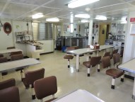
The mess deck is where we eat our meals, grab a snack, or sit to read or chat at off times.

The dinner tonight is carne asada (fajitas) and you can smell it cooking. Bob and Mark, our cooks, have also served us white bean chili, salads, cheeseburger sliders, roasted chicken, fish, pork roast and vegetables, seasoned hash browns, bacon and eggs, all kinds of fresh fruit, not to mention the desserts like blueberry cobbler and cinnamon rolls. 

With all this great food, I was thankful to find that the crew makes places on the ship to work out! Some do “laps” by walking the ship a few dozen times around. There is an exercise room with weights and bikes and more equipment can be found in other places around the ship.

Science and Technology Log

The Woods Hole UOP (Upper Ocean Processes group) and rest of the team is now in a rhythm of deploying probes and gathering data. Like super sleuths, we are tracking a cold, relatively fresh water mass which originates inValparaiso and moves northwest. This water mass lies under the warm, salty surface layer.  At 50 meters depth, there is a clear distinction in the water masses since we began deploying the UCTDs. Just like a detective matches fingerprints, we have a “fingerprint” of the cold, fresh water.  A seasonal thermocline has been identified! Nan Galbraith, a programmer from WHOI, is processing all of the numerical data into useful images.  The surface water layer (graph) has a temperature about 20º C and salinity > 35 ppt (parts per thousand). At 50 meters depth, the temperature abruptly drops to 17º C and falls to 7.5º C at 400 m which is the bottom depth we are testing; similarly the salinity drops to 34.1 ppt. Although we are traveling through water about 4,000 m deep, we are interested in tracking this water mass. I’m still having trouble remembering approximate Celsius to Fahrenheit conversions: here’s a link to help.

http://www.wbuf.noaa.gov/tempfc.htm

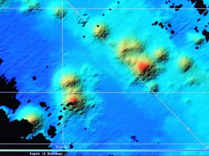
However, another factor has come into play which we must consider. We are nearing a tectonically active area – the Nazca Ridge, a fracture zone. There are many seamounts, some of which have not been previously mapped. Whoever is on watch must look at the ever-changing multi-beam sonar display to look for seamounts – we don’t want the instrument to slam into an underwater volcanic mountain! The closer we get to the Nazca Ridge, the higher the likelihood of seamounts.

Seamounts
We constantly monitor the multi beam sonar display for bathymetry and sea floor features. The red or yellow circular areas are seamounts.

All in all, we will cover about 2,268 miles until we reach the Galapagos, so the multibeam sonar is a critical piece of navigation equipment.

On the watches, as we deploy the UCTD probe, which looks like a 2 foot long bullet, weighing about 10 lbs., and good teamwork is the hallmark of a successful launch and recovery. Sometimes we are working in the dark with only the ship’s lights and a flashlight. I have learned how to make a splice in the line – the cord is only about 1 mm in diameter! This line and any splice must be strong enough to hold onto a 10 pound instrument being dragged though 400 m of water at 12 knots. Picture 3 people at 4 a.m. on a moving ship, using tiny instruments to sew a splice in a 1mm line, all while the line is attached to the winch. Like a surgical team, we are all focused and know what tool the splicer needs next. Sometimes quick thinking and a problem solving mindset is needed. There was a foam “bumper” that we had been attaching to the line to cover the probe when it got close to the boat. The probe is expensive and this was protection from it slamming into the steel fantail. When it was lost in the water, the team on watch used a nearby mop to protect the probe while reeling it in. On the next watch, Seb figured out a different solution.

Why does it smell like diapers in here?

Back in the lab a different bit of problem solving with the scientific method is going on! Often when buoys are recovered, they are fouled — covered with barnacles and all kinds of organisms, fishing line, etc. that get caught in them. Jeff Lord – mechanical whiz – has hypothesized that applying a better “anti-fouling” substance can keep these from affixing themselves to the equipment. He has liberally applied Desitin, a zinc oxide ointment, to the instruments. This is the same treatment for diaper rash on babies’ bottoms!  So therefore, the odor in the lab reminds us of diapers. It will be a year before we know if Jeff’s hypothesis is correct, because after the STRATUS 12 buoy is moored, it will be a year before it is recovered.  What do you think will happen?

Some of the science party was given a tour of the ships technical equipment behind the scenes. Bud Hale explained not only all of the monitors and ship terminology, but took us down into the equipment rooms where we encountered a gravimeter (measures gravity variations), modern gyros with optics and GPS (measures pitch, roll and heave).

Bud Hale
Bud is an expert on all things technical on the ship. He is more than happy to tell you how any of it works!

Tomorrow, we hope to see the desalination plant on the ship which gives us our fresh drinking water.

UCTD files
After each deployment of a UCTD, data is uploaded into the computer. I’m starting to get the hang of it!

Sue Oltman: Getting My Sea Legs, May 22, 2012

NOAA Teacher at Sea
Sue Oltman
Aboard R/V Melville
May 22 – June 6, 2012

Mission: STRATUS Mooring Maintenance
Geographical Area: Southeastern Pacific Ocean, off the coast of Chile and Ecuador
Date: May 22, 2012

Science and Technology Log

It’s finally the day we will leave port!  I’m awakened by the feeling of my bed shaking and a crash of something falling, this could have been an earthquake.  The science party boards the boat after breakfast and spends a lot of time fastening all equipment down and securing it to shelving; even my laptop needs to be affixed to my desk with Velcro.

My stateroom is on the 02 deck, which is one floor below the main deck. I’m in 02-50-2 with a private “head.” Everything is made of steel (even the toilet and shower) and is bolted down, too.

Stateroom
Here’s where I will sleep for the next two weeks…and take naps so I can do my 4 a.m. watch shift.

As we move out towards open  ocean, the R/V Melville – all 278 feet of it –  is moving northwest at about 11-12 knots and all seasoned hands comment on how calm the seas are. However, there are factors such as pitch, roll and heave which I am not accustomed to!  Ocean conditions affect the ship with  roll of about 3° to 5°  – swaying back and forth to the left (port) and right (starboard.)  Pitch is the hull tilting forwards or backwards and is about 1 ° or less.  Heave is vertical displacement of the ship and is a meter or less. The roll starts getting to me after dinner, despite the sea-sick medicine! Fortunately, after lying down for a while, the sickness passes.

Next, I went up to the lab where all the monitors are to see what I can learn about our course. Watching the multi-beam sonar display (from the Bathymetry XTD) as the ocean floor drops out from below us is fascinating. An array of 191 SONAR beams maps it out. The colors appear like the depth color key on classroom maps we use of the ocean floor – dark blue where deepest and yellow or even red where it is shallower.

The monitors showed the ocean floor depth as it dropped from 2500 m to about 4700 m in an hour or so. The ship was beginning to sail over the trench!

This monitor shows the bathymetry or depth of the ocean in real time as we sail.

Two safety drills were conducted – a fire drill and an abandon ship drill. There was also training on the scientific equipment we will deploy, the UCTDs  (underway conductivity, temperature and depth probes), and ARGO drifter buoys. Sean Whelan led the class on UCTD training and Jeff Lord prepped us on the drifters. These smaller buoys will be released and will float freely, carried by the currents.

The UCTDs will be deployed hourly around the clock on the aft deck (back of the ship.) Salinity and density are derived from these values. The probe is dropped into the water, will sample for about 2 minutes to 400 m or so and then be retrieved. The casting line is then rewound onto the spool to be ready for the next deployment like a sewing machine bobbin being wound.  The data is transmitted to the computer via Bluetooth when a magnetic key is inserted to activate it.

UCTD
A UCTD is taken back to the surface after gathering data. Sean Whalen, an Engineering technician, taught the class on UCTDs.

Everyone was trained how to use the winch as they will need to use it on watch. Each watch has 3 people and is 4 hours long, and then you have 8 hours off. My assigned watches are 0400 – 0800 hours and 1600-2000 hours (4 to 8) so I will need to alter my sleeping schedule! Those on watch must stay in the downstairs lab and conduct UCTD releases during those hours. The instruments inside the UCTD are very sensitive and costly and must be handled very deliberately.

There is one more session. Keith – the ship’s “res tech” or resident technician – conducts a CTD handling class. The “rosette: is the circular frame in which water sampling devices called CTDs are placed to take water sampled in international waters. These are different from the UCTDs because deep zone water is sampled for salinity and temperature. This will be done about 7 times on this cruise. It is large and the instruments are housed in a sturdier casing so it is heavier and the winch operator must lower this into the ocean with a crane.

We are looking forward to be seeing some great sunrises and sunsets from our research vessel during watches!

Sunset
Enjoying the spectacular sunset with me are Elsie Denton, volunteer translator, and Jamie Shambaugh of NOAA.

Sue Oltman: Greetings from the Ring of Fire! May 20, 2012

NOAA Teacher at Sea
Sue Oltman
Aboard R/V Melville
May 22 – June 6, 2012

Mission: STRATUS Mooring Maintenance
Geographical Area: Vina del Mar, Chile
Date: May 20, 2012

Personal Log

I’m staying in the town of Vina del Mar, about 90 minutes from Santiago and close to the busy port city of Valparaiso.  Learning a bit more about the culture of this country. Once again, I’m reminded how useful it is to know other languages. The science team from WHOI (affectionately called by its acronym, pronounced hooey) is led by Dr. Robert Weller, the chief scientist, a renowned oceanographer whose expertise is moorings. The mooring for STRATUS 11 will be recovered and STRATUS 12 will be deployed. Another significant science contribution of WHOI is the Alvin submersible. Alvin has explored the mid-ocean ridge in the Atlantic Ocean extensively.

Valparaiso
From the R/V Melville, in port, looking towards shore, there are many smaller touring and fishing boats in addition to cargo vessels.

Last time, I shared that earthquakes are almost expected here, so there is a common concern about tsunami preparedness.  In 2010, many Chileans lost their lives due to a tsunami they did not know how to react to. The country’s leaders are trying to implement better evacuation plans, so there is a large public drill planned in about a week here. There are banners in the street announcing the upcoming drill!  Think of the school fire drills we have…a whole country will practice in a coordinated earthquake and tsunami drill to ensure that lives will be spared in the future.

Valparaiso colorful street
Many of the steep hills of Valparaiso were colorful – the homes and artistic graffiti.

The port of Valparaiso is very colorful and busy, with a lot of commerce taking place. New cars enter South America here, as does steel for construction and other goods. The U.S. oceanographic research  ship R/V Melville arrived and the team has been getting equipment ready for the mission ahead.  The new buoy and instruments have been shipped here separately, and the technician, Val Cannon, has been checking them out before they are deployed.It’s not an everyday event that a US Navy ship enters Chile, so local government will take the opportunity to somehow enrich their citizens.  A school group visited for a tour of the ship as well as an overview of the scientific research happening aboard the vessel. The Melville science crew prepared to give a presentation to the group of high school students on Saturday morning.  The research vessel  Melville had come into port on the heels of 2 weeks of  earthquake research by Oregon State University scientists. This scientist gave a presentation about her work first.

Scientists present to Chilean students
Dr. Sebastian Bigorre, WHOI, and Elsie Denton, translator, and I speaking to the students.

Next, Dr. Sebastien Bigorre (Seb) gave a talk about the atmospheric research in the Stratus project which I will elaborate more about in upcoming blogs.  He showed them the location of the stratus mooring and why that location is chosen – it is in the area of persistent stratus cloud cover in the lower atmosphere.  Did you know that some ocean water masses have a specific “fingerprint? ” This allows scientists to determine where that water mass travels to, and this reveals more information about winds and currents in the region.I gave the students an overview of the Teacher at Sea program and how NOAA  provides resources for science instruction, and invites teachers to experience cutting edge science in the oceans.  Teachers at Sea create new lessons and curriculum related to their cruises which are then shared on the NOAA website. The Chilean science teachers asked if these materials were available to them as well, and were happy to find out that they were.

Today was also a busy day of shipboard work inValparaiso, heavy work and long hours of getting the project’s equipment aboard. Crates and crates of equipment and gear was unloaded, involving cranes and heavy lifting by all.  Even the top scientists are not exempt from the gritty hard labor! In the video clip, you will see Dr. Weller and other hardworking, versatile scientists assembling the mooring on deck. The ocean is all around us, but no one is swimming in it.

The water is pretty cool here, due to the Peru current which bring Antarctic water masses northward. There is continuous upwelling from about 1,000 meters where the thermocline is.

The coastline is on the edge of the Peru-Chile trench, part of the network of tectonic plate boundaries surrounding the Pacific. While on land, we are on the South American plate, and when we put out to sea, we will be above the Nazca plate.  This is a subduction zone where the trench descends to as deep as 6,000 meters in places! The Nazca plate is subducting under the continent. The R/V Melville will mostly be sailing in water in the 4,000-4,500 meter range.  This teacher is ready to set sail! Comment below to let me know your questions about the ship.

Answers to previous polls:

The KMS hat won! Upwelling is the movement of deep,cold, nutrient rich water to the surface. The cables can be over 4000 meters long.

Sue Oltman: Moorings and More, May 10, 2012

NOAA Teacher at Sea
Sue Oltman
Aboard R/V Melville
May 22 – June 6, 2012

Personal Log:

In a few days, I will be en route to Santiago, Chile and meet up with the Stratus  research team that I will spend about 3 weeks with.  The scientists are from the Woods Hole Oceanographic Institute in Massachusetts.  After some preparation, the Melville will depart from the port of Valparaiso.

Moorings will be referenced many times, I expect – and that’s not something we  often encounter in landlocked Atlanta, GA.  When something is “moored” it is fastened or secured in place by a cable, rope or anchor. So a boat can be moored as an alternative to being tied to a dock in a marina. Obviously, there will not be any docks and marinas in the middle of the eastern tropical Pacific!

Stratus surface mooring
One of the moorings we will recover during this mission (photo courtesy of WHOI)

The scientific instruments involved in the Stratus project are integrated into buoys and into the cable that secures them to the ocean floor. These surface data buoys are moored and are sometimes just called moorings. There are buoys in the ocean that collect all kinds of data way beyond just temperature – wind direction and speed, salinity, conductivity, dissolved oxygen, and more. Some provide early detection of potential tsunamis, a concern in this area – last month,Valparaiso experienced a 6.8 magnitude earthquake, and in Chile, earthquakes are no surprise.

Location map of Stratus project
The Stratus project focuses on a specific area in the open ocean. (image courtesy of WHOI)

Speaking of earthquakes, the largest earthquake ever recorded occurred in Chile in 1960. Technology and our ability to predict and warn has come a long way in the last 50 years! Stratus is using data to predict climate change – this cruise will be the 11th mission of the team to collect more data for this project. It is exciting to think of the potential this holds for us!
[polldaddy poll=6211066]

Personal log:

NOAA survival suit
Here I am with the NOAA survival suit – in a San Diego museum!

Ship life is going to be different for me! I’ve learned that there are some similarities in rules to the Rock Eagle and Jekyll Island field trips I’ve taken with students! First of all, I will sleep in a bunk bed; next, I am only allowed to wear flip flops in my cabin – no open toed shoes on the deck of the ship. I’ll be expected to clean my room and my own bathroom before I leave the ship. Absolutely no swimming is permitted! One thing that will be different is that there will always be someone working around the clock – and that means someone will always be sleeping. Safety is of the utmost importance – one of the first things we will do is conduct a safety drill. Instead of a PFD, NOAA uses survival suits in case of emergency.
What do you want to know about the ship? Send me your question by leaving a comment.

Sue Oltman: Mrs. Oltman Prepares to Set Sail!

NOAA Teacher at Sea
Sue Oltman
Aboard R/V Melville
May 22 – June 6, 2012

Hi everyone! I’m a 6th grade science teacher in Georgia getting ready for an exciting time of learning and exploration – in a hemisphere I’ve never visited! I hope you’ll visit and comment on this blog often.

Originally, I’m from New York, but I have been in Atlanta since attending college at Georgia Tech. Before I was a teacher, I was an engineer, but I’ve always wanted to be a scientist!

A self portrait when I was 6 years old!

For 5 years, I’ve been thinking about applying to the NOAA Teacher at Sea program and am so honored to have been selected.  The ocean has always been a fascinating place to me – the waves, the sand, the shells, the life, the vastness. I’m a scuba diver and love boating. Many vacations have brought me to the ocean, but this time, my visit is not for leisure but joining in important research.

The research is about predicting climate change by observing ocean and lower atmosphere interactions. There is a lot I have to learn about this topic, and I hope to share as much as possible in future blogs. One new fact I learned when reading up on NOAA’s climate program, is that there are ocean floor features which can increase upwelling, which in turn decreases surface temperatures. On our cruise, the Melville will sail near some tectonically active areas – and that means the ocean floor may be changing, even as I sail above it!

I’ve memotioned I will visit the southern hemisphere: the Melville  sets sail from the port of Valparaiso, Chile and my next post will likely be from there! I need to pack for potentially cold weather, even as my students get ready for summer vacation. Can you help me decide what hat to wear?